APPENDIX C
MEMORANDUM
Landscape Architecture
Planning
Urban Design
Strategic Services
120 East Main Street Aspen, Colorado 81611
970.925.8354
To: Byron Head, WFRC; Tayler Jensen, West Jordan; Adam Olsen, Midvale City
From: Design Workshop
Date: February 14, 2023
Project Name: West Jordan & Midvale Station Area
Plan
Project #: 7024
Subject: Existing Plan Review
The following memo includes a review of existing plans and documents created by and for West Jordan that are relevant to the Station Area Plan.
Contents
West Jordan City Center Station Area Plan 2
Previous City Center Plans 6
Redwood Road Corridor Master Plan Report 9
General Plan DRAFT 13
Briarwood Redevelopment Project Area Plan 17
Midvale City General Plan 2016 19
Midvale Main Street Small Area Plan 20
Midvale Redevelopment Agency: Main Street Project Area (Budget and Impact Report) 22
Midvale Downtown Arts District - Market Study 24
Image | 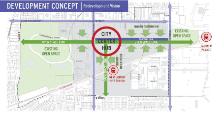 |
Document Name | |
Written By |
Unknown Consultant |
Publication Year |
2019 |
Summary (50 –100 words) |
The 2019 City Center Station Area Plan outlines a 30-year redevelopment plan for 2,200 dwelling units (30-60 gross DU/acre) and envisions the neighborhood as West Jordan’s main street. The plan utilizes UTA’s TOD principles, prioritizing walkabilityand bicycle access, connectivity, and mixed-use development with access to green/public spaces. |
Pull Quote |
“Existing auto-oriented light industrial uses don’t support a walkable mixed-use city center area.”
“Properties owned by the Jordan School District and UTA have strong potential for redevelopment and these agencies are willing partners in the process.” |
Key takeaways |
Overall Concept
- The overall concept includes a center city hub a quarter-mile north of the TRAX platform with open space links (bike and ped trails) connecting to regional destinations. The east-west open space link connects the Veterans Memorial Park and West Jordan Parks and Recreation, Gardner Village TRAX station and the Jordan River Trail. The north-south open space link connects the city center hub to the station and the neighborhood south of the TRAX line.
- Development along the open space links should be oriented inward to support planned retail and commercial development with strong ped and bike facilities.
- Parcels would be redeveloped on a fine-grained grid (based on UTA’s TOD guidelines), that creates a pattern of walkable blocks.
Transportation
- Redwood Road provides significant drive-by exposure for the city center area (40k ADT) and is a potential future BRT route. The Jordan River Trail is a regional recreational walking and biking amenity. Planned future recreational amenities include the 1300 South bike lane and Rail Trails. |
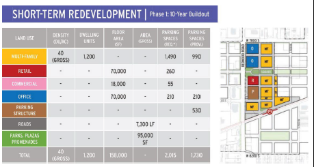
Existing TRAX Red Line and bus service provide transit options. UTA’s TOD guidelines include short- to-medium block lengths (no longer than 350 ft.) and a grid-like street network. - A proposed extension of 7900 South, connecting Redwood Road to 1300 West, will increase trips along this roadway, supporting planned retail and commercial uses while alleviating congestion on parallel routes. - New public ROW are 60 ft wide and include: two 12 ft. sidewalks, two 8 ft. parking lanes, two 10 ft travel lanes. - A north-south station promenade would strengthen the ped and bike connection and include: one 12 ft sidewalk, one 20 ft promenade, two 8 ft parking lanes, two 10 ft travel lanes. - A neighborhood park is proposed south of the transit station to create a focal point and sense of place for residents. The park is connected to the station platform by the station promenade. Long-term Redevelopment (30-year buildout) - Multi-family housing around the TRAX station area, in the center of the long- term redevelopment area in a variety of housing typologies. - Office located near the corner of Redwood Road and 7800 South - Research office park located near the intersection of 7900 South and 1300 West - Retail anchor and street-oriented shops off Redwood Road to provide high drive-by visibility and convenient access to encourage development of a retail main street. - Commercial uses located along the promenade street within ground floor of multi-family buildings and parking structure. Ground floor commercial should have transparent windows, canopies and include entrances off the promenade street. Commercial should also be located near the intersection of 7800 South and 1300 West to capture drive by visibility. - Parking structure at the intersection of Redwood Road and 8020 South 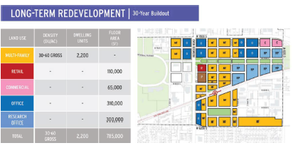 Short-term Redevelopment (Phase 1b: 10-year buildout) - Phase 1b illustrates a 5-10 year city center vision and includes a range of uses. Eight property owners will be impacted in the short-term (full list on page 27). It includes additional Multi-family Housing north of the Phase 1 housing and Office at the corner of Redwood and 7800. |
 Short-term Redevelopment (Phase 1a: 5-year buildout) - Phase 1a prioritizes the following projects: Center City Square, Station Promenade, Station Square, Multi-family housing (located on the UTA property immediately adjacent to the station), Parking Garage and Ground Floor Commercial (located on Sundborn property), Retail Anchor and Shops (located on school district property, adjacent to City Center Square). 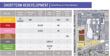 | |
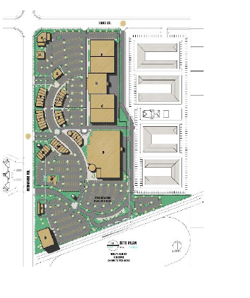
Key images | 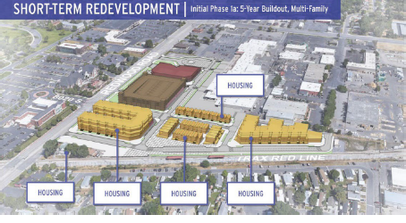 |
Other Plans Referenced & Data Sources | Redwood Road Corridor Master Plan UTA TOD Guidelines • |
Previous City Center Plans
Several plans have been created for City Center over the decades. They are summarized below.
 | BABCOCK – City Center Concept, 2014 Pros: skybridge creates a sense of place, not sure how feasible it is; some believe a bridge will be necessary to cross Redwood Cons: UDOT is not interested in traffic calming at the expense of efficiency; separation of uses, horizontal, heavy retail
|
 | Summary: ∙ Horizontal mixed-use (it was more about construction economics at the time the plans were developed than anything else; city council is in favor of height) ∙ Strip mall type retail ∙ Large box retail ∙ Focuses on redevelopment of School District parcel and UTA parking lot ∙ Inward focused: green spine from TRAX station to new core ∙ Proposed phasing: large retail first, then housing |
 |
BEECHER – The Jordan Town Center, Year Unknown
Pros: phasing, differentiates what’s market-driven vs. gov’t funded;
Cons: not walkable, big box stores Summary: ∙ Redevelopment on both sides of TRAX lines ∙ Horizontal mixed-use ∙ Inward focused ∙ Large box retail as anchors ∙ Series of central spaces/ nodes connected through boulevard style streets ∙ No clear connection to existing civic uses or Veterans Park, 4 phases |
∙ Perspective shows large amounts of surface parking lots/ not walkable or pedestrian friendly/ car- oriented development | |
 |
J STATION – Master Plan, Year Unknown
Pros: N/A
Cons: giant parking lots, not walkable
Summary: ∙ 24 units x acre ∙ Horizontal mixed-use ∙ Focuses on redevelopment of School District parcel and UTA parking lot ∙ Large box retail ad strip mall type commercial ∙ Large amounts of surface parking lots/ not walkable or pedestrian friendly (north side design is a huge parking lot with some retail around it) ∙ Car oriented development ∙ Lack of community or gathering spaces ∙ Lack of connections across Redwood Road or other areas ∙ Residential redevelopment focuses on south side of TRAX lines |
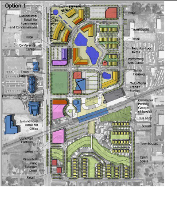 |
LMN – West Jordan Downtown Revitalization Plan
Pros: land use element and urban use element document Cons: internal focused, don’t connect beyond the site
Summary: ∙ Mostly horizontal mixed-use, some vertical mixed-use ∙ Establishes some connections to west side of Redwood Rd. proposes defined pedestrian crossings at two points ∙ Incorporates Bigham Creek ∙ Importance of green areas and central spaces (Town square, green space/ core, linear green area along creek) ∙ Recycle some ideas |
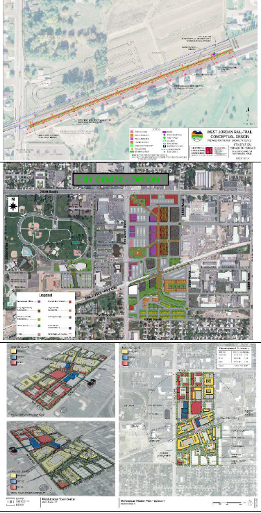 |
RAIL TRAIL – West Jordan Rail Trail Conceptual Design, 2009
Summary: Creates connectivity between stations and Jordan River Trail, Incorporate into SAP concepts (bring into Cad) |
UNKNOWN – Similar to LMN layout
Pros: pedestrian connectivity north-south and east-west off main corridors
Cons: frontages, lots of parking | |
IBI –
Pros: office and residential-wrapped parking structures Cons: not tall enough (9-13 stories could get support) |
Cover Page | 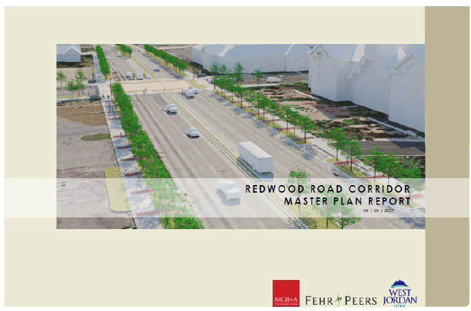 |
Document Name | |
Department Issuing |
West Jordan City (written by MGB+A and Fehr & Peers) |
Publication Year |
2017 |
Summary (50 – 100 words) |
The Redwood Road Corridor Plan provides recommendations and strategies for improving the aesthetics, safety, and functionality of the street to attract businesses and residents and to set the West Jordan City apart from other cities along the corridor. Redwood Road is a regionally significant state highway (SR- 68), owned and maintained by UDOT. Due to varying land uses along the 4-mile corridor, a single design concept is not appropriate along the entire corridor. The plan notes that as plans are developed for City Center TOD, it will be important to coordinate design
themes with what is being planned for Redwood Road. |
Pull Quote | “The design amenity guidelines use principles of urban design to improve the aesthetics and walkability of the corridor with the overarching goal of creating a sense of place and arrival when traveling to West Jordan City or within the city to visit one of the many commercial centers.” “Pedestrian accessibility at West Jordan City Center Station ranks 45th out of 50 TRAX stations.” |
Key takeaways | Summary
- The plan includes two key features: intersection treatments to enhance ped crosswalks and general aesthetics; maintains 3 travel lanes in each direction. The addition of medians adds beautification and slows traffic.
- Ped enhancements are concentrated in commercial centers and bike routes are encouraged in residential neighborhoods adjacent to the corridor for safety and comfort of cyclists |
- The plan includes design guidelines to improve the overall aesthetics and walkability of the corridor with the goal of creating a sense of place and arrival. Recommendations include wider sidewalks with accent paving, wider planting strips, planted medians, artistic elements at key intersections, and coordinated site furnishings
- Pedestrian accessibility in the study area is emphasized, as well as connection across the corridor from the public buildings to the future TOD. Specific recommendations or guidelines are not provided.
- Note: The market and economic analysis was completed before Covid-19. Key Metrics
- Walkability index = 30%
- Ranked 45th out of 50 TRAX stations in walkability
- Approximately 217 driveway access points (average spacing of 54 feet)
- Average 245 collisions/year (2013-2017) Right-of-Way
- The current ROW is 106’ including park strips and sidewalks. Curb-to- curb paving is about 86’.
- Per the proposed concepts, for 3 travel lanes in each direction and a turn lane, the curb-to-curb paving requires roughly 100’. With additional space for sidewalk and park strip features, the minimum ROW is 120- 130’. The plan suggests full property takes to acquire the land as opposed to acquiring small parcels close to the roadway. Crash Data
- Safety concerns along the corridor are attribute to several factors including but not limited to; vehicle speed, multiple driveway access points, relatively high vehicular volume, inadequate bike/ped facilities/crossings.
- Over a period of 2 years (January 2012 – December 2013), there were 735 collisions, for an average 245 per year. Most collisions reported were due to failure to yield right-of-way (34%), following too closely (26%), and improper turning (11%).
- 14% of collisions were associated with commercial or residential driveways, 20% were associated with T-intersections (which are not signalized), 22% were reported to occur at 4-leg intersections (signalized), while 41% were not associated with a roadway junction or feature Proposed Concept
- The proposed concept for the study area section of the corridor includes: |
- Streetscape enhancements: special paving, lighting, bus shelters, gateway elements to create a sense of place and arrival - Intermediate center medians create opportunities for landscaping and visually reduce the corridor’s expansiveness - Minimal impediment to traffic flow or turning movements - Reduction of driveway curb cuts where feasible, especially near intersections - Emphasis on improvements of ped/bike facilities (shared multi-use path, separate from roadway) with wide landscaped buffer between path and road - Signalized mid-block crossings - Improved transit pullouts and circulation 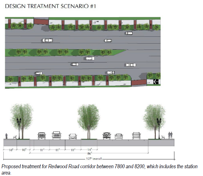 Proposed treatment for Redwood Road corridor between 7800 and 8200, which includes the station area. |
Key images | 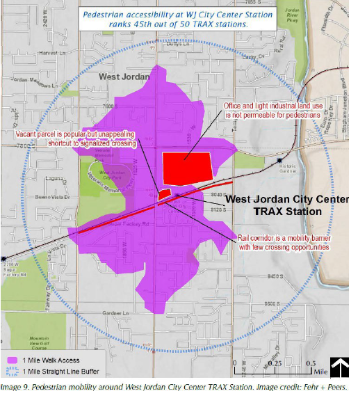 |
Other Plans Referenced & Data Sources | N/A |
Cover Page |  |
Document Name | |
Department Issuing | Planning Department |
Publication Year | 2022 |
Summary (50 – 100 words) | The General Plan update provides a long-term vision for the West Jordan City. Chapters focusing on City Center and TOD provide general guidelines for planning and design of the City Center TOD, which should exemplify a high level of urban design. Emphasis in the TSOD overlay is on bike and pedestrian accessibility, comfort, convenience, and visual interest. Plans for this overlay should prioritize the public realm, including public art, gateways to emphasize arrival and departure, and mixed use development. |
Pull Quote | “Provide facilities for people, i.e., public restrooms, places to relax, and protection from the elements.” |
Key takeaways | Social Health and Opportunity statement: Social health and opportunity means that residents have equal access to jobs, transportation, education, housing, government, and recreation. [It] also means protection from nuisances and hazards. Investing in social health and opportunity supports the other sustainability components of environmental protection and economic vitality. Strategies relevant to this plan include locating high-density residential and mixed-use development near public transit facilities, encouraging the development of senior and affordable housing, and equally distributing recreational amenities throughout the City. Growth Management: The current population is around 117,000 people and available land is about 75% developed. A growth management challenge is planning infrastructure for expansion west while providing capacity for infill and redevelopment on the eastern half of the city. Some key takeaways: (1) Future sales tax generation will require providing retail opportunities close tor residential and employment areas; (2) reducing commute times, congestion, and air pollution are major concerns that can be addressed by encouraging employment closer to residential growth areas and employment centers that offer work-from-home options; (3) quantity, character, and mix of housing have a significant impact on the location of future employment centers. Housing must meet the needs of workers. The City recognizes that it needs to accommodate increasing demand for a wide range of housing choices. TOD is one of the 11 growth management strategies outlined in the General Plan. |
Urban Design: High quality urban design is important to maintain the quality of development and character of neighborhoods in West Jordan. Gateways are of particular importance and the study area includes 3 listed gateways zones: 7800 South, Redwood Road, TRAX Stations. Creating a sense of place and arrival will be important factors in the final concept plan. The General Plan also highlights Crime Prevention through Environmental Design (CPTED) principles, including natural surveillance (“eyes on the street”), natural access control, territoriality, maintenance, activity support, and order maintenance - all of which are naturally aligned with TOD design guidelines. City Center is a top priority and should exemplify a high level of urban design through appropriately scaled buildings, visual coherence, and a sense of place. Land Use: TOD is highlighted as a land use typology with significant benefit to the community, including incentivizing public transit, increasing affordable housing, providing opportunity for mixed use, and increasing tax base for property and sales tax. Cons of TOD include the necessity of willing property owners, and that they place burden on existing water and sewer facilities (if a zoning change with higher density is implemented without careful planning). City Center and Neighborhood Transit Station Overlay District (TSOD) Center Land Use: The purpose of this designation is to create pedestrian- oriented areas with a densely integrated and synergetic mix of residential, commercial, professional office and civic development in a traditional main street or downtown character. Relevant goals in this section include: 1. Provide well-designed, aesthetically pleasing, and efficient City Center and Neighborhood Center areas. 2. Provide well-designed, aesthetically pleasing, and efficient commercial areas within the city of West Jordan. 3. Evaluate and update sections of the zoning ordinance and zoning map to incorporate more mixed-use development in the City. 4. Encourage the location and redevelopment of public facilities and associated services to best serve the needs of the community. 5. Encourage the imaginative, creative, and efficient use of land in master planned communities. Transportation: Relevant to this plan are the existing standards for street typologies listed on page 86 of the General Plan. The transportation goals outline in the plan that are relevant to this site are: 1. Establish a multi-modal transportation system 2. Provide safe and efficient movement of traffic within the City 3. Develop a transportation management program 4. Ensure the use of bicycle and pedestrian transportation systems |
5. Support residential traffic calming 6. Improve the aesthetic quality of the City’s streets Housing: Like many communities along the Wasatch Front, West Jordan is negatively affected by a shortage of available housing. More units are required to accommodate growth. Housing guiding principles and goals include: 1. Preserve the identity of West Jordan as a family-oriented community through providing a range of housing types, styles, and sizes to fit the various needs of the family lifecycle. 2. Provide housing that serves residents who require specialized facilities or locations (i.e. seniors/group homes) Environment, Water: Relevant goals include: (1) Support all economically justifiable options for environmental sustainability; (2) Support the development of neighborhood gardens; (3) Implement and encourage principles of sustainable water use and water-conserving landscaping for new development. Parks and Recreation: Relevant goals include 1. Maintain Parkland service levels 2. Provide a diversity of parklands and associate activities 3. Provide and maintain recreation facilities that meet the needs of residents and that are financially stable 4. Support implementation and extension of the citywide trails network 5. Promote use of trails as an alternative transportation mode | |
Key images |  |
Other Plans Referenced & Data Sources | ∙ |
Image | 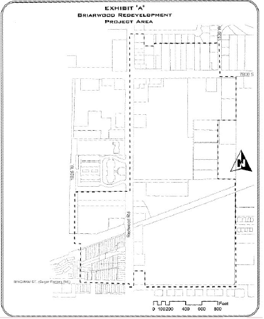 |
Document Name | |
Department Issuing | Redevelopment Agency of West Jordan City |
Publication Year | 2003 |
Summary (50 –100 words) | The Briarwood RDA Project Area Plan addresses an area (“Exhibit A”) in transition from industrial and single-family residential and underutilized commercial to and active commercial, office, high density residential and mixed use, central business district and transit-oriented use area. |
Pull Quote | |
Key takeaways | Overall Redevelopment Objectives 1. Remove structurally substandard buildings and replace them with new construction, rehabilitation of appropriate buildings, eliminate deficiencies such as irregular lot subdivision, improper drainage and weeds 2. High level of architecture, landscape, and urban design principles 3. Strengthen tax base and economic health of the region 4. Support improvement of public transportation systems and multi-modal users 5. Improve pedestrian infrastructure and public spaces including plazas 6. Eliminate blighting factors and influences 7. Promote the implementation of community-developed goals and General Design Objectives Developers are expected to obtain the highest quality design and development and each proposal will be considered subject to approvals by various City departments and agencies. The overall redevelopment will: |
1. Provide an attractive urban environment 2. Blend harmoniously with surrounding areas 3. Provide for well-landscaped areas in relation to new buildings 4. Provide parking areas appropriately screened and/or landscaped to blend harmoniously with the area 5. Provide open space and pedestrian areas which are oriented to maximum use and optimum separation and protection from vehicular traffic 6. Maintain off-street parking to the maximum degree 7. Enhance the built environment and sense of place of West Jordan downtown area 8. Establish a higher density and mixed-use center and central business district Plan Limitations 1. A time limit of no more than 5 years after the effective date of this plan for the Agency to commence acquisition of land through eminent domain 2. A time limit of no more than 25 years after adoption of this plan for tax increment from the RDA to be paid to the Agency unless the taxing entity committee consents to a longer period The plan states, “The increase in property values will help transition land from its current residential use to commercial, office, and high-density residential uses.” The 2023 DW plan should include recommendations to prevent or avoid displacement. | |
Key images | |
Other Plans Referenced & Data Sources | The plan is consistent with and conforms to the city’s General Plan, Downtown Action Plan (DAT), Downtown Overlay Zone, and Brownfield Economic Redevelopment Plan |
Cover Page |  |
Document Name | |
Department Issuing |
City of Midvale |
Publication Year |
2016 |
Summary (50 – 100 words) |
The General Plan establishes a vision for the future of the city and serves as a policy document for decision making for the development of Midvale over the next 8-10 years. |
Key takeaways |
- There are opportunities for better east-west connectivity by ensuring that new developments have good connections to existing developed areas. o As space for transportation is limited, planning must not only identify opportunities for merging compatible transportation modes, but also ensure complementary uses of different streets and transportation routes. (Vehicular Network maps pg. 27-28)
- The City of Midvale has the potential to be a much more walkable city. The area's TRAX stations provide an important non-vehicular access route to the region. The area of Midvale east of I-15 contains many pedestrian destinations barricaded by high-volume, fast-moving traffic. Redevelopment of these areas will provide opportunities to improve walkability, especially near TRAX stations. A more direct connection could be made from the Main Street area to the Bingham Junction TRAX station. (Existing and Planned Pedestrian Network map pg. 37)
- Creating attractions that can be developed at Bingham Junction can increase the amount of tourism in Midvale
- Number of opportunities within Midvale for improved connectivity including the extension of Bingham Junction Blvd. through Jordan Bluffs
- There are opportunity areas surrounding Bingham to broaden transportation networks by incorporating pedestrian, bicycling and transit alternatives
- Opportunity to develop art through the Bingham Junction public art program |
- Goals: o Improve roadway connectivity to the east and west in Bingham Junction o Improve pedestrian and bicycle path connectivity to the Main Street and Jordan Bluffs areas o Support redevelopment of the adjacent area to the east to blend and enhance any redevelopment if the Jordan Bluffs Area - Maximize the walk shed around the three TRAX stations. Only 53% of the Fort Union and 35% of the Bingham Junction half mile walk sheds are achieved |
Cover Page |  |
Document Name | |
Department Issuing | VODA Landscape + Planning |
Publication Year | 2018 |
Summary (50 – 100 words) | The purpose of the Small Area Plan is to take advantage of existing opportunities to strengthen the City’s economic base through the revitalization of the Main Street area. The goals of this planning document are built on City goals from the Midvale General Plan, the Redevelopment Agency, and the Economic Development Department. |
Key takeaways | Area Recommendations - Transportation and multi-modal connectivity issues are largely due to the surrounding infrastructure that encloses the neighborhood. Need to address pedestrian and bicycle network gaps - Historic preservation and facade improvement - Current urban design and public realm diminish the quality and experience of Main Street - improve the experience by creating a sense of place and improving neighborhood experience |
- Growing interest in more walkable, urban residential development Transportation and Connectivity - Transportation assets include close proximity to a TRAX rail station, arterial roadways, and nearby access to I-15. A central location in the valley is also a significant asset that should be amplified for business expansion. - Main Street needs to improve connection to TRAX station and Jordan River Parkway - Existing pathways connecting Main Street and parking areas are subpar Street Improvements - With narrower car lanes and other features introduced, neighborhood streets of Midvale could become more friendly to pedestrian and bicycle use Urban Design & the Public Realm - New projects should design more active and public facing uses for key frontages along public streets in the area. - The streetscape elements along Main Street should be consistently implemented along the corridor. The south end of Main Street has the highest concentration of complete street elements. - Future streetscape improvements include: Street trees, planters, paving, striping, bump outs (new ones should match existing bump outs), street furniture, lighting, signage. - Most existing parking lots in the commercial area would benefit from an upgrade. Trees and landscape improvements in the parking areas will further communicate support of a high-quality urban environment. - There is a lack of public space in the Main Street area. The only existing public space is a paved area for basketball and tennis. Providing additional public space will meet the needs of local businesses, residents, and consumers. It will also be useful for increasing visitor numbers and visit time. - Midblock connections are an effective way to increase pedestrian connectivity within a neighborhood. There is currently one midblock connection on Main Street located halfway between Center Street and 1st Avenue. Increasing visibility will help pedestrians locate the connection. It can be made more pedestrian friendly with new amenities such as upgraded landscaping and benches. |
Cover Page |  |
Document Name | |
Department Issuing | Redevelopment Agency of Midvale City |
Publication Year | 2020 |
Summary (50 – 100 words) | Midvale City has a unique and historic Main Street. Because very few cities in Utah still have a historic Main Street corridor, Midvale City is seeking to improve and leverage this asset. One goal, as stated in the Midvale Main Street Small Area Plan, is to redevelop Main Street in such a way as to create a sense of place for the City. The Midvale Redevelopment Agency believes that it can support the City to develop a stronger and more defined sense of place through redeveloping the historic Main Street. |
Key takeaways | Section I: Executive Summary: The Agency will actively pursue and promote initiatives that will support increasing the density within the Midvale Area. Based on historic growth rates, it is safe to assume that the Main Street CDA is unlikely to redevelop in any significant way without some intervention. The Agency’s primary motivation for redeveloping the Main Street Area is to support placemaking efforts within the City. This means preserving, enhancing, and celebrating the historic nature of Midvale’s Main Street. It means creating an environment that attracts people to gather, recreate, shop, dine, and build lasting memories. To create a more vibrant, attractive, and welcoming environment along Main Street, the Agency will actively support the development and enhancement of local artists and art. Actions/Initiatives: |
∙ Supporting parking garages adjacent to Main Street, between the 4th Depot Street and Center Street. The Agency anticipates a 25 percent increase in commercial space within the Area. ∙ Increase density and add additional business space in the Area involves the Agency actively supporting businesses’ efforts to renovate their buildings and add additional square footage. ∙ Repurpose the Midvale Museum site to serve as an arts center. ∙ Promote and support façade improvements ∙ Sponsor and support events and improve connectivity to and throughout the Area Benefits of supporting the redevelopment of the Main Street Area: ∙ Tax: Net fiscal benefit to the taxing entities, including the School District, County, and City. ∙ Jobs: The Project Area budgeting model projects an additional 25 percent commercial space created through redevelopment. Jobs are anticipated to be in the commercial retail sales and service sectors, including food and beverage sales and services, clothing and other consumer goods sales, and providers of personal services. The additional commercial space is further projected to induce the creation of an additional 203 jobs. ∙ Affordable Housing: The Agency has and will continue to generate significant tax increment revenues earmarked for affordable housing. The Agency plans to use housing funds from the Main Street CDA and the other two redevelopment areas to directly incentivize the development of mixed-use space along Main Street. Section II: Introduction: The Agency and City believe that with the support of the local taxing entities, the Main Street area can be redeveloped to increase the assessed value of the area, provide more spaces for businesses, create more jobs, increase the stock of affordable housing, and enhance the arts. Section III: Main Street Community Development Area Revised Budget: The Agency will budget 77% of the tax increment revenues it receives toward redevelopment activities. Assuming 20 years of participation, the Agency will collect $15,242,750 and allocate $11,736,917 toward redevelopment activities. Section VI: Community Impact Study: ∙ Supporting and enhancing the arts is a key and critical component to the Agency’s strategy for redeveloping the Area and establishing a sense of place. ∙ Nearly $1.9 million will be allocated to public art. The agency will look for and seize opportunities to promote and preserve public art within the area: covering utility boxes with artistic coverings and commission murals within the area. Successfully developing a sense of place will be the Agency’s crowning achievement in the area. |
Exhibit B: Main Street Redevelopment Case Studies (pg.30-37) o Park City, Utah o Provo, Utah o Casper, Wyoming o Campbell, CA |
Cover Page |  |
Document Name | |
Department Issuing | Webb Mgmt |
Publication Year | 2021 |
Summary (50 – 100 words) | Study done by Webb Mgmt, a management consulting practice for the development and operation of cultural affairs. This study determines whether there is a market opportunity to create a new downtown arts district in and for the community. |
Key takeaways | The City of Midvale can and should consider the development of the Arts District along the southern portion of Main Street in downtown Midvale, for the following reasons: - Arts districts represent a proven model for the redevelopment of Main Street areas towards the pursuit of goals that have been established by the City of Midvale. - There is a dearth of arts facilities in the city and thus the opportunity to recruit programs and facilities to the community within the context of district development. - Midvale residents are active arts participants likely to respond positively to programs and events offered in their downtown area. |
- There are already a number of arts facilities and programs at the south end of Main Street, and these groups and facilities are enthusiastic about the possibility of being included within a more active area that is branded as a district. - The experience of other communities that have developed arts districts confirms that the city of Midvale could achieve significant returns on only moderate investments in preparing Main Street for the district concept. - Market area was defined as a local (36,000 people in 2025) and 15-mile radii regional (1.4 million 2025). Market segments are described as younger and diverse in income (though relatively low) and ethnicity (Hispanic). - In this market area, people are more likely to be active arts participants rather than passive ones. That is to say, they are more likely to take a class or go out for karaoke as opposed to attending a classical music concert or a theatre production. - Midvale is home to a half-dozen tattoo studios, with a concentration on Main Street. They are the most prevalent type of arts business in the downtown and showcase artists in a multitude of ways. Dance Studios are the second most prevalent. - Arts facilities can and should work within existing historic buildings given the importance of that character and authentic feel for creative activities. Galleries, studios, and other types of arts facilities do not overly burden historic structures with heavy loads and traffic. - Comparable Arts Districts: Casper-Wyoming, Tieton- Washington, Boise-Idaho, Culver City- California, Rino and Santa Fe Districts Denver- Colorado, Santa Fe- New Mexico, Recommendations - Examples: Some cities have been successful by being very intentional about the development of an arts district, while other districts have been developed in a much more organic fashion, with limited investments and influence on the part of public sector planners. - The question for City of Midvale leadership is how and to what degree should they drive the development of an arts district along Main Street. |