Chapter One
INTRODUCTION
INTRODUCTION
A General Plan gives the City the chance to establish long-range goals and policies that set the direction for how the City should maintain existing development, plan for future growth, provide public services, and enhance existing qualities that are unique to the City of West Jordan.
Each chapter within this General Plan analyzes current conditions within the City, identifies assets, challenges and opportunities, and recommends ways to capitalize on current strengths and resolve deficiencies through intentional guiding principles and goal setting.
A guiding principle sets a value that guides City decisions, whereas a goal is a desired measurable condition that supports the policy. All of the guiding principles contained within this General Plan can be found within the various chapters and at the end of this document. City goals may be found in various City master plans.
There may be occasions when strict adherence to a guiding principle or goal is not always practical. Utah State Code also provides guidance for application of the General Plan. Any inconsistencies that may exist between the text of the General Plan and the Future Land Use Map should be resolved in favor of the text.
The General Plan is used as the primary reference in developing amendments to the City Code as the General Plan is the framework for land use decisions. It should be referenced by developers, administrative and political bodies of the City of West Jordan, and by other governmental entities. The General Plan should be flexible enough to adapt to changing conditions. It is not a static document but should evolve with the City.
The General Plan also includes a Future Land Use Map and other maps illustrating the recommendations of the General Plan. The guiding principles, goals, and implementation strategies tie the plan together, and the maps convey their findings.
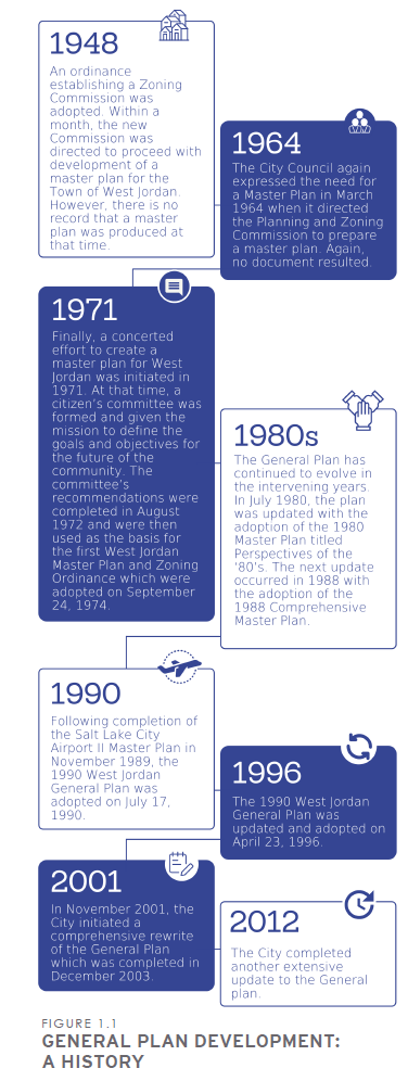
The recommendations of the General Plan are implemented through specific plans or programs.
In fact, the City of West Jordan has adopted several other plans to manage day-to-day and long-term operational needs of the City. Some examples include the following:
• Moderate Income Housing Plan (which is included in this General Plan per Utah State Code)
These plans, although separate documents, are part of and are interconnected with the General Plan. As a result, these documents should also be consulted when making infrastructure and other management and operational decisions for the City.
These master plans are routinely updated to keep pace with current conditions within the City. The General Plan, Future Land Use Map and individual master plans should be consistent with each other. The General Plan and Future Land Use Map should be consulted when individual master plans are updated.
The goals and policies in the General Plan are intended to have broad City-wide application, while the individual plans are more specific as to how the guiding principles of the General Plan are to be implemented. For this reason, the more detailed goals, policies, and implementation strategies should be in the individual master plans rather than in the General Plan where possible.
When conflicts exist between the following types of documents, the following hierarchy of documents shall be implemented:
1. The approved West Jordan City Code and Public Works and Engineering Standards (highest level);
2. The approved West Jordan City Master Plans, i.e. Water Master Plan, Storm Drain Master Plan, etc. (next highest level); and
3. The approved West Jordan City General Plan, including all the elements (chapters) and the Future Land Use Map (lowest level).
The General Plan should be updated every five years, or as determined by the City Council to keep it current and relevant to changing conditions within the City. The General Plan is a guide to decision-making, and while this format implies that the guiding principles represent a preferred course of action, their use is not mandatory and no one guiding principle is binding on the City. The City Council may amend the General Plan with a majority vote.
Community Engagement in General Plan Creation
General Plan Committee
The General Plan Committee is a 15-member Council-appointed ad-hoc committee responsible for assisting the Planning Commission in updating the General Plan. The General Plan Committee, which acted as a steering committee, provided valuable insight regarding planning issues affecting the City.
Survey
A survey was conducted in March through May of 2021 to seek public input on issues and challenges facing the City.
A variety of questions were asked, with many of them relating to redevelopment, job growth, housing and housing mix, parks and open space, traffic, and neighborhood revitalization.

Notice to participate in the survey was posted on the City and City Council social media accounts. Postcards were mailed to 7,500 residents (2,500 per zip code) and an invitation to participate in the survey was included with every utility bill. This effort generated 427 responses from City residents.
The responses from this sample of residents were analyzed and incorporated into the various chapters of the General Plan where applicable.
It should be noted that the responses received were not uniformly distributed across geographic regions of the City, as shown in Figure 1.2, and therefore may not be fully representative of all resident interests.
Public Open House Meetings
Public open house meetings were held on August 23, 2022 and August 31, 2022 to gather public comment on the General Plan.
Loading...