APPENDIX B
Memorandum
Date: February 14, 20223
To: West Jordan City, Midvale City Design Workshop, Inc.
From: Fehr & Peers
Subject: Midvale and West Jordan Station Area Plans - Existing Transportation Conditions
UT23-2411
___________________________________________________________________________________________________________________________________________________
___________________________________________________________________________________________________________________________________________________
This memorandum documents existing transportation conditions around three Utah Transit Authority (UTA) light rail stations, part of a broader system known as TRAX The three stations in question are:
∙ Bingham Junction Station, Midvale
∙ Historic Gardner Station, West Jordan
∙ West Jordan City Center, West Jordan
The purpose of evaluating the existing transportation conditions around these three stations is to inform Station Area Plans for each station, intended to enable land use changes adjacent to each station and improve multimodal access to each station through targeted infrastructure improvements. These changes should lead to an increase in transit ridership by making transit more convenient through improved access and travel time competitiveness.
This memorandum usually treats the three stations independently, however, some portions of this document (such as the review of existing plans) does not.
Study Areas
Given their proximity to each other along the UTA Red Line, the three station areas are immediately adjacent to one another (if not explicitly overlapping), with some key roadways and multimodal paths serving two of the three stations.
2180 South 1300 East | Suite 220 | Salt Lake City, UT 84106 | (801) 463-7600 | Fax (801) 486-4638 www.fehrandpeers.com
Bingham Junction Station
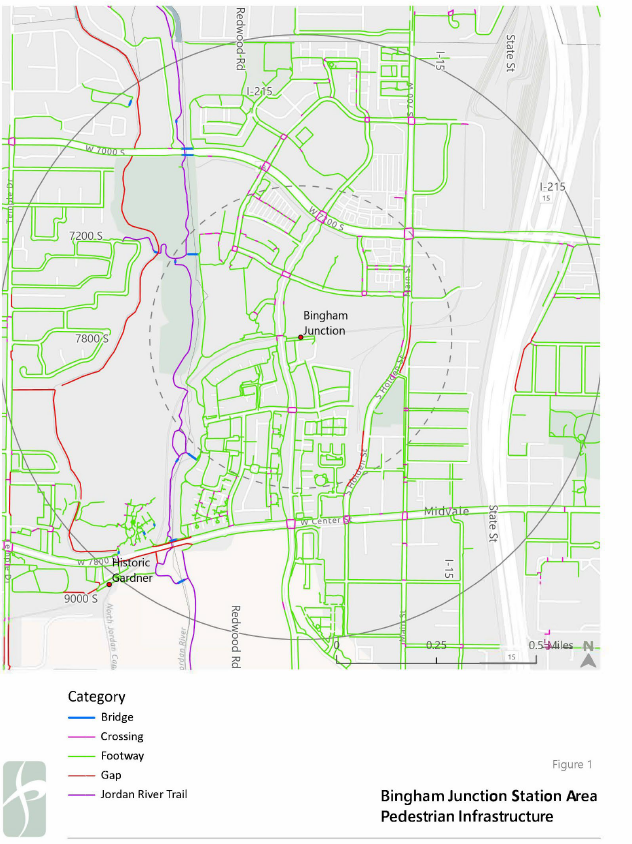
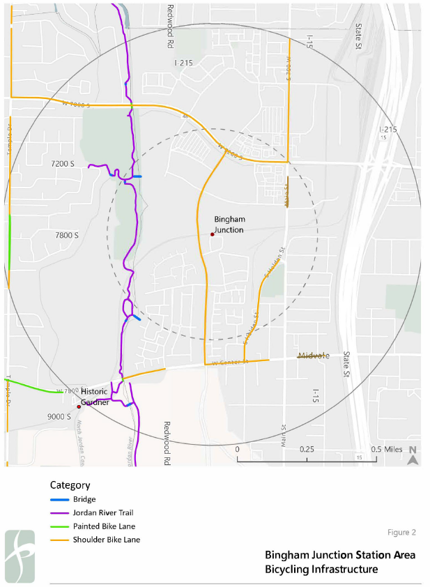
Bingham Junction Station, which is served by the UTA Red Line and F570 and F202 bus lines, is immediately accessed via Bingham Junction Boulevard, and is situated between 7200 South to the north, I-15 to the east, Center Street to the south, and the Jordan River to the west. Adjacent land uses include new residential development to the south and west, and there are a handful of large commercial office buildings to the north, including Overstock.com's headquarters. Downtown Midvale is less than one-half mile from Bingham Junction Station, however transportation connections are convoluted due to the nature of recent residential developments to the south and topography.
Historic Gardner Station
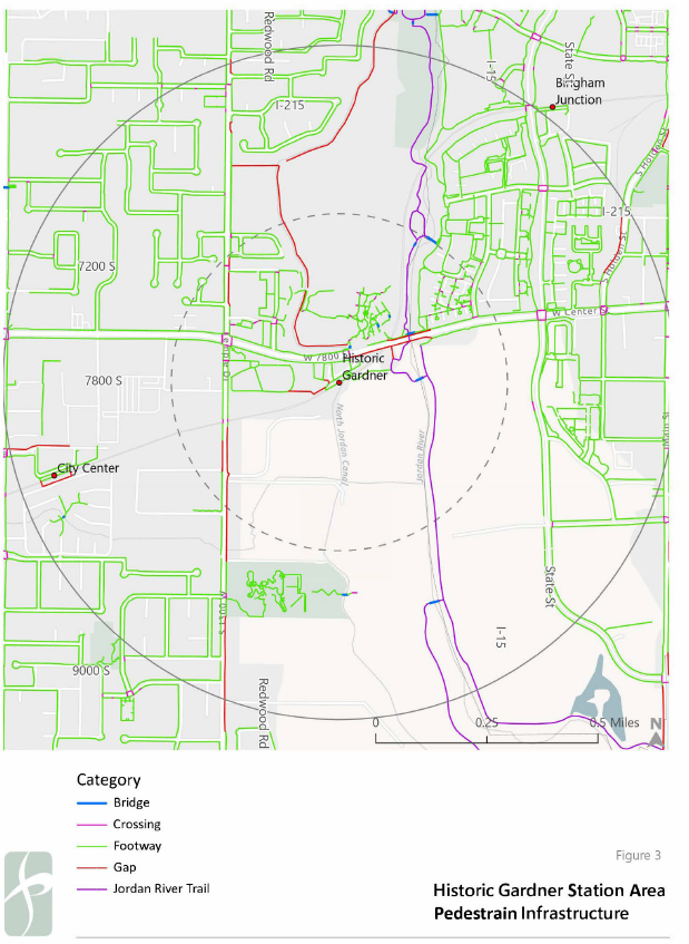
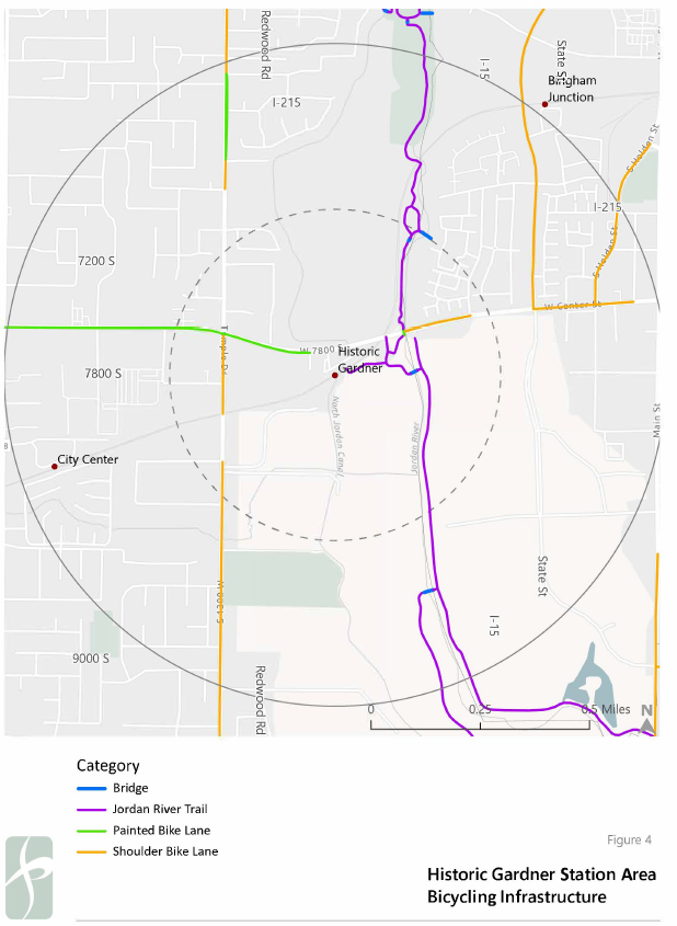
Historic Gardner Station is served by the UTA Red Line and the F578 bus. Historic Gardner Station is accessed by 7800 South (the continuation of Center Street in West Jordan), and is immediately south of Gardner Village, a popular shopping and dining destination. Immediately to the west of the station is Pioneer Hall, an historic structure initially used as a meeting house of early pioneers of the Latter Day Saints community and is now available to rent for events. Land south of the station is divided into larger parcels that are primarily used for agricultural and commercial uses, with the parcel immediately south of the station home to an asphalt recycling plant and general landscaping supplies. These larger parcels to the south are largely impermeable from a transportation perspective, limiting connectivity to the station. The Jordan River lies less than one thousand feet to the east of the station, which also constitutes the West Jordan-Midvale municipal border. The Jordan River Trail, a regional, multimodal connection, runs parallel to the Jordan River and is easily accessible from the station.
West Jordan City Center
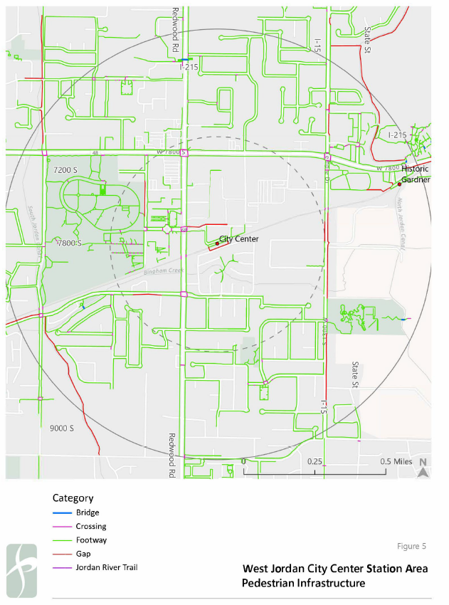
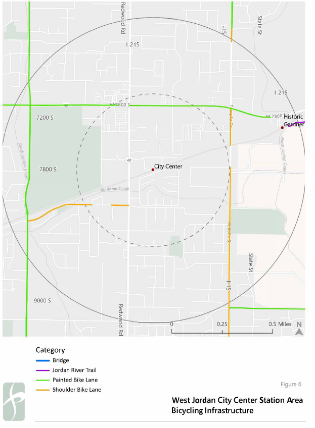
The West Jordan City Center station is served by the UTA Red Line and the 217 and 218 bus lines. The station is accessed via W. 8020 South, a small spur connecting the station and its dedicated parking to Redwood Road, a critical north-south connection that functions as West Jordan's Main Street. In the immediate vicinity of the station, the TRAX line acts as a barrier between primarily residential uses to the south and commercial and institutional uses to the north and west. North of the TRAX line, the area is dominated by surface parking surrounding municipal buildings and some commercial uses along Redwood Road and 7800 South. South of the TRAX line, single- family homes are the predominant land use.
Existing Transportation Networks
A handful of key roads and multimodal connections are shared among the three station areas and will appear throughout this section as a result.
Bingham Junction Station
Key roadways in the station area include:
Bingham Junction Boulevard
Running north-south, Bingham Junction Boulevard is the only route for vehicular access to the station. Bingham Junction Boulevard is a four-lane road with a center turn lane and a posted speed limit of 35 mph. Sidewalks are provided on both sides of the street. Bingham Junction Boulevard primarily provides a vehicular connection to 7200 South to the north of the station and to 9000 South to the south of the station, both of which provide access to I-15.
7200 South
Running east-west, 7200 South is a six-lane roadway with two left-turn lanes and dedicated right- turn lanes at signalized intersections. Sidewalks are provided along both sides of the street, and a narrow, concrete median separating directions of travel. Pedestrian crossing distances are long and there are no on-street bicycle facilities or parking in the study area. The posted speed limit in the study area is 40 mph.
Center Street
Running east-west, Center Street is a four-lane roadway with a center turn lane that functions as a left-turn lane at signalized intersections. Right-turn pockets are provided at some signalized intersections. In the study area, a striped parking lane is provided and is wide enough in some areas to function as a bicycle lane, however it often stops short of intersections. Center Street does not provide access to I-15. The posted speed limit is 35 mph.
Main Street / Holden Street / 700 West
Going by three different names in the study area, the roadway running roughly north-south parallel to Bingham Junction Boulevard and I-15 is a four-lane roadway with left- and right-turn pockets at most intersections. There is a striped shoulder, acting as a de-facto bicycle lane throughout the study area, and inconsistent sidewalks are provided along both curbs. Along some portions of the road a raised, concrete median is provided. The posted speed limit in the study area is 35 mph.
Active Transportation Connections
Active transportation infrastructure in the station area includes consistent sidewalks along most area roads, striped shoulders along major roads that act as de-facto bicycle lanes, and the Jordan River Trail (JRT), a regional cycling and walking connection. The connection between Bingham Junction Station and the JRT is somewhat circuitous, owing to development patterns and bridge connections to the west side of the Jordan River, where the primary north-south connection is located.
Historic Gardner Station
Key Roadways in the station area include:
7800 South
Running east-west as a continuation of Center Street to the east, 7800 South is a four-lane roadway with a center turn lane. West of Historic Gardner Station, on-street bike lanes are provided in both directions of travel, with on-street parking provided along both curbs. Sidewalks are provided along both sides of the street. The posted speed limit is 40 mph.
1300 West
Running north-south, 1300 West is a two-lane roadway with a center turn lane in the study area. Sidewalks are inconsistently provided on each side of the street, with striped shoulders acting as de-facto bicycle lanes. The posted speed limit is 35 mph.
Active Transportation Connections
Active transportation infrastructure in the study area include recently improved connections to the JRT, on-street bicycle lanes along portions of 7800 South, and sidewalks on most area roadways. The station area, owing to its proximity to the JRT and the want for connections to the trail, is home to several walking and bicycling bridges, an undercrossing at 7800 South, and several spurs and connectors to local destinations including the Zions Bank Technology Center.
West Jordan City Center
Key Roadways in the station area include:
Redwood Road
Running north-south, Redwood Road is a six-lane roadway that extends as far north as North Salt Lake and as far south as the Point of the Mountain. Redwood Road is a Utah Department of Transportation (UDOT) facility, and acts as West Jordan's Main Street. In the study area, there are sidewalks provided on both sides of the street, though pedestrians are mostly traveling immediately adjacent to vehicular traffic with frequent driveways interrupting both sidewalks.
There is on-street parking provided in the area, and there are no on-street or parallel bicycle facilities. The posted speed limit is 45 mph.
7800 South
Running east-west, 7800 South is a four-lane roadway with a center turn lane which converts to dedicated left-turn lanes at signalized intersections. Sidewalks are provided on both sides of the street with frequent driveways or other curb cuts between 1300 West and Redwood Road.
Standard, painted bicycle lanes are provided along 7800 South in the study area, as well as curbside parking lanes. The posted speed limit is 40 mph.
Active Transportation Infrastructure
Active transportation connections include on-street bicycle lanes along 7800 South and 2200 West at the western edge of the sturdy area. Within Veterans Memorial Park, various off-street paths are provided for recreational uses, though none explicitly designed for cyclists.
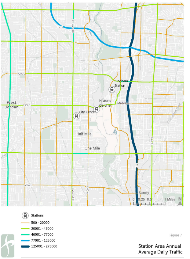
Existing transportation networks, as well as UDOT-calculated Annual Average Daily Traffic (AADT) in the station areas are presented in Figures 1-7.
Existing Plans
Several existing plans were reviewed as part of this existing conditions assessment. Only one of these plans, the UTA Five-Year Service Plan, covers all three station areas.
Midvale General Plan (2016)
The Midvale General Plan was adopted in 2016 and includes ambitions for Midvale in the realms of land use planning, open space development, and transportation. While many transportation- focused elements of the plan focus on portions of Midvale outside of the Bingham Junction Station Area, the Transportation and Mobility Vision Statement resonates with the goals of this station area planning effort:
"MIDVALE FACILITATES A LIVABLE COMMUNITY BY ENSURING A SAFE, INTER- CONNECTED, MULTIMODAL INTERNAL TRANSPORTATION SYSTEM, AND BY FACILITATING MULTIMODAL CONNECTIONS TO NEIGHBORING COMMUNITIES AND THE REGION."
Other relevant elements of the Transportation and Mobility section of the 2016 General Plan include improving multimodal access to all TRAX stations in Midvale, thereby increasing the utility of and accessibility to transit. This includes establishing a connection between Bingham Junction Station and Main Street. The General Plan supports the implementation of structured parking in the area of Bingham Junction Station to reduce the prevalence of surface parking lots.
Mid-Valley Active Transportation Plan (2021)
The Mid-Valley Active Transportation Plan was developed to address multimodal connectivity challenges in Salt Lake County at a regional level. The cities of Taylorsville, Murray, Millcreek, Holladay, Cottonwood Heights, and Midvale worked together to develop "recommendations for a backbone network that will enhance bicycle and pedestrian connectivity within the region."
In the study area surrounding Bingham Junction Station, the Plan recommends implementing standard, on-street bicycle lanes along Bingham Junction Boulevard, 700 West / Holden Street, and Center Street. The plan also includes recommendations for similar facilities on Main Street between Center Street and 700 West / Holden Street, though that recommendation appears untenable due to geometric constraints. Lastly, the Plan recommends converting Tuscany View Road into a neighborhood byway (similar to the concept of a Bicycle Boulevard) west of Bingham Junction Boulevard, providing another connection the Jordan River Trail.
West Jordan General Plan (2012)
Adopted in 2012, the West Jordan General Plan includes a host of goals for affecting the transportation and mobility landscape in West Jordan, including substantial streetscape improvements to critical roadways including Redwood Road and 7800 South. At the time of adoption, TRAX service at both West Jordan stations was very new (having commenced in August 2011), and there is relatively little emphasis on elevating transit use in West Jordan, instead focusing on Citywide opportunities and needs.
West Jordan Transportation Master Plan (Undated)
The West Jordan Transportation Master Plan, possibly produced in 2015, focuses exclusively on transportation and traffic in West Jordan. In considering both regional and local needs, this Plan identifies recommended improvements on area roadways with an eye towards increasing vehicular capacity on area roads and at key intersections. This Plan suggests that West Jordan will pursue widening the portion of 7800 South east of Redwood Road to seven lanes, and widening 1300 West to an unknown number of lanes.
The West Jordan Transportation Master Plan includes recommended trail alignments and crossings within West Jordan, including an east-west trail just south of City Center Station and a north-south trail roughly aligned with the North Jordan Canal. The Plan also indicates the need for an elevated trail crossing at Redwood Road at Bingham Creek if the potential east-west trail is constructed.
West Jordan Active Transportation Plan (2019)
Adopted in 2019, the West Jordan Active Transportation Plan includes a list of prioritized active transportation improvements in West Jordan. Separated into three tiers, only one project in the station areas rising to the level of Tier 1, that being implementing buffered or separated bicycle lanes on 1300 West within City limits.
The Plan suggests that an off-street, multimodal path along Redwood Road as a Tier 3 improvement. Such an improvement (or other streetscape improvements) along Redwood Road are included in various plans for West Jordan.
UTA Five Year Service Plan (2023)
While the latest draft of the UTA Five Year Service Plan does not include changes to fixed route transit service in the study area, it does include the expansion of on-demand service throughout West Jordan and Midvale. UTA On Demand is a service similar to Uber or Lyft (transportation network companies) that has proven popular in areas served by its initial rollout in Draper, Riverton, Herriman, Bluffdale, and South Jordan.
Station Area Parking
Existing surface parking lots at the three Stations being evaluated as part of this plan represent opportunities for space reallocation. To identify potential opportunities based on parking utilization, multiple data sources were reviewed as no central repository of TRAX park-and-ride utilization is currently maintained. A summary of parking supplies at each station is presented below in Table 1.
Table 1: Parking Supply by Station
Station | Standard Parking Stalls | ADA Parking Stalls | Total Parking Supply |
Bingham Junction Station | 193 | 6 | 199 |
Historic Gardner Station | 125 | 5 | 130 |
West Jordan City Center | 325 | 11 | 336 |
Source: Fehr & Peers, 2023.
Aerial Imagery
One source for parking utilization is aerial imagery from Google Earth. Google Earth does not provide detail on day of week or time of day at which aerial images are captured, instead only providing month and year for each capture. Average parking occupancy, as well as maximum parking occupancy as determined by Google Earth-provided aerial images from July 2019 through June 2022 (seven total captures) is presented below in Table 2.
Table 2: Parking Utilization by Station Measured by Satellite Imagery
Station | Average Parking Utilization | Maximum Parking Utilization | ||
Bingham Junction Station | 18 | 9% | 381 | 19% |
Historic Gardner Station | 11 | 8% | 242 | 18% |
West Jordan City Center | 18 | 5% | 611 | 18% |
Notes: 1.) Captured July 2019. 2.) Captured October 2021. | ||||
Source: Fehr & Peers, Google Earth; 2023.
Direct Ridership Model (2017)
In 2017, Fehr & Peers worked with UTA to develop a regression-based model to estimate parking demand at UTA TRAX and Frontrunner stations. Underpinning this model development was a data collection effort at all UTA-maintained park-and-ride facilities in their service area. This effort included evaluating parking demand during different periods throughout the day. The average and maximum utilization at each station is presented below in Table 3.
Table 3: Parking Utilization by Station Measured by Manual Counts
Station | Average Parking Utilization | Maximum Parking Utilization | ||
Bingham Junction Station | 70 | 36% | 1011 | 51% |
Historic Gardner Station | 40 | 32% | 54 | 43% |
West Jordan City Center | 123 | 38% | 152 | 47% |
Notes: 1.) Recorded during the hour of 11:00 AM - 12:00 PM | ||||
Source: Fehr & Peers, UTA; 2017.
Park-and-Ride Master Plan (2014)
UTA developed a Park-and-Ride Master Plan in 2014 to identify park-and-ride locations at which additional parking capacity was warranted and where excess capacity existed. Additionally, UTA used this mater plan to develop recommendations on which locations should be pursued for future transit-oriented development and which should be prioritized for parking. None of the lots at stations evaluated as part of this study were identified as being priorities for either new development or additional parking supply. Average parking demand at each station as of 2014 is presented below in Table 4.
Table 4: Parking Demand by Station According to UTA Park-and-Ride Master Plan
Station | Average Parking Utilization | |
Bingham Junction Station | 35 | 21% |
Historic Gardner Station | 51 | 39% |
West Jordan City Center | 104 | 31% |
Source: UTA, 2014.
While there is no clear consensus among these three sources on parking demand at these three stations, all available information suggests that there is excess parking supply based on recent and historical demand.
Multimodal Access
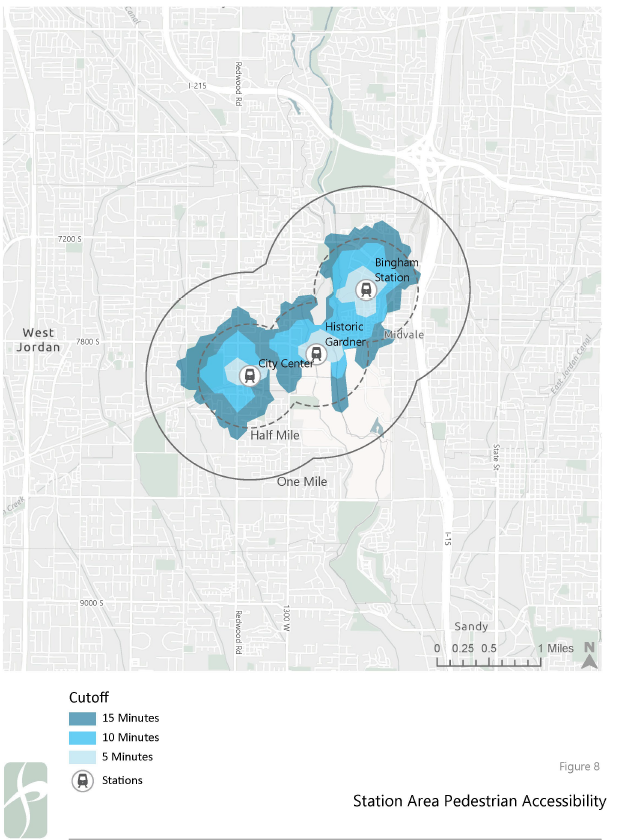
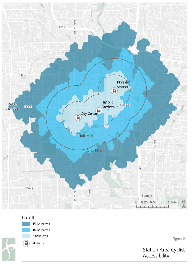
Understanding walking and bicycling access to the three stations in question is essential to identifying potential infrastructure improvements that might increase the convenience of transit.
Accounting for typical travel time of each mode, accessibility analyses reveal that a 15-minute bicycle ride on existing roads extends well beyond one mile measured in a straight line from each station. Given the general level of roadway connectivity in each station area, and the speed at which a typical casual cyclist can travel, access within a reasonable travel time is uniform.
However, a lack of safe and comfortable cycling infrastructure likely acts as a deterrent to accessing each station by bicycle.
Conducting a similar analysis for accessibility analysis for a 15-minute walk at typical speeds reveals several key barriers in each station area:
∙ The lack of straightforward connection to the southeast of Bingham Junction Station towards Maini Street means that most of downtown Midvale is more than a 15-minute walk from the station
∙ The asphalt recycling plant south of Historic Gardner Station and lack of north-south crossings means that points south of the station are largely inaccessible within a 15- minute walk
∙ The lack of north-south crossing over the TRAX line adjacent to the City Center station limits access to areas south of the station
Results of these accessibility analyses and their associate walksheds and bikesheds are presented in Figures 8 and 9.
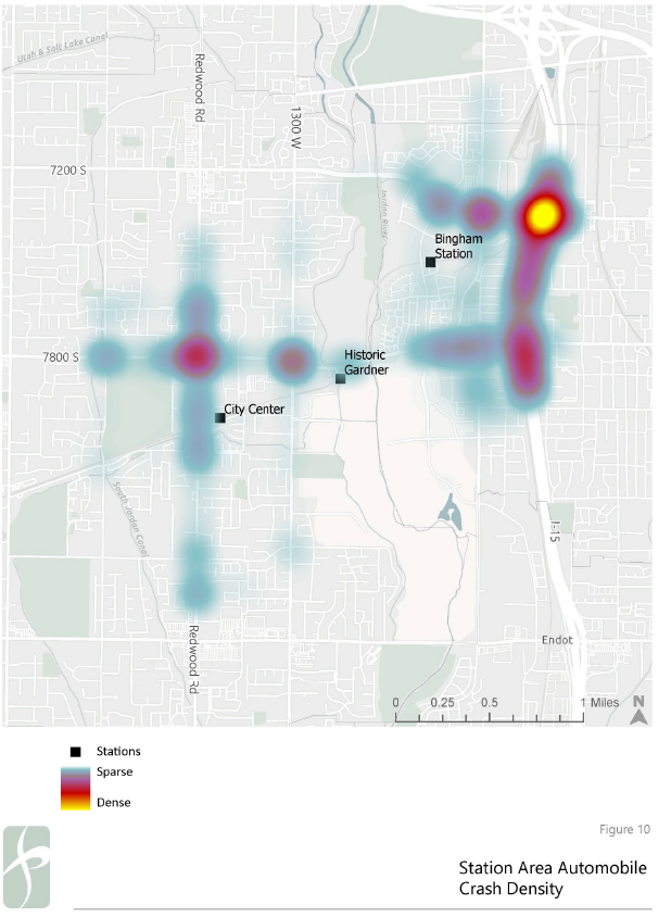
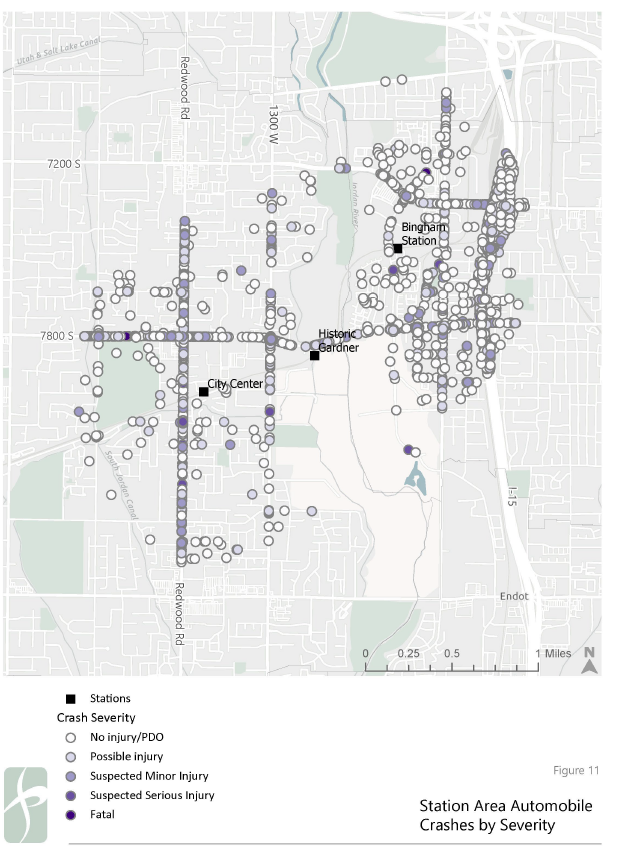
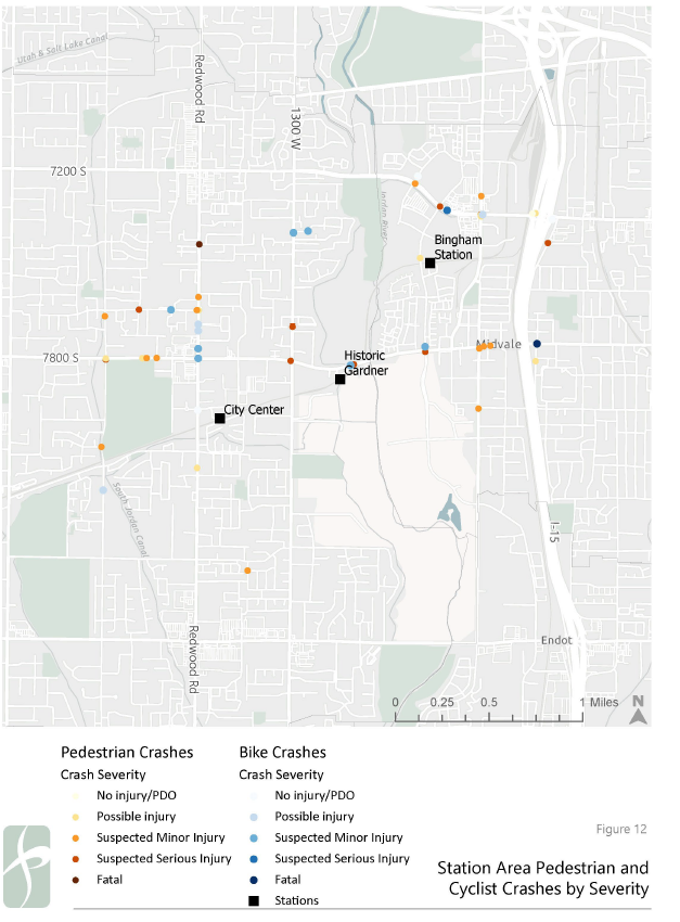
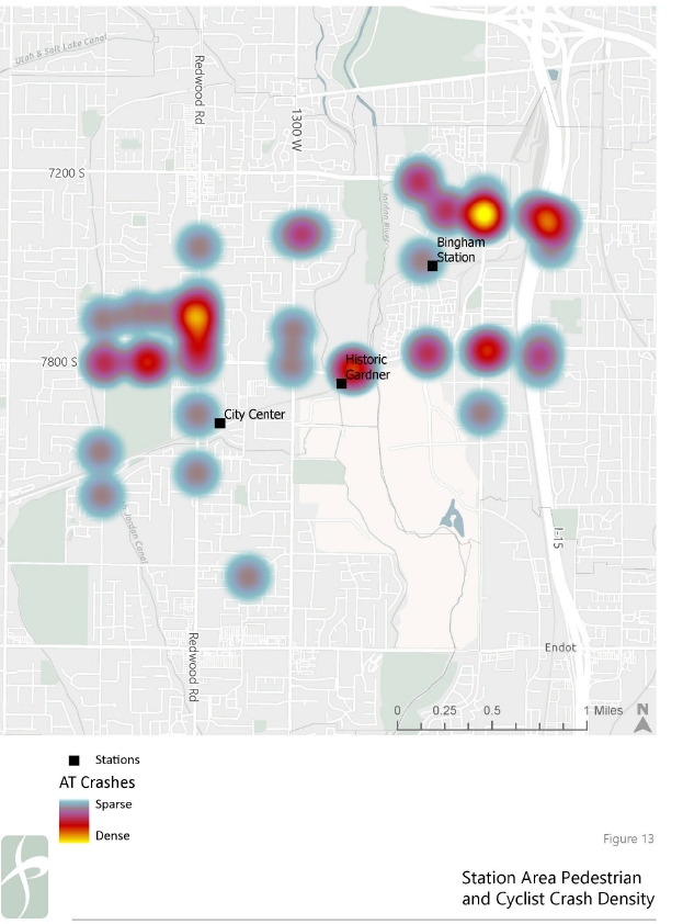
Safety
UDOT maintains a database of recorded traffic crashes on all roadways in Utah. To assess traffic safety conditions in the station areas examined as part of this study, traffic crashes recorded from January 1, 2018 to December 31, 2022 were analyzed within a one-mile radius of each station area. Given that these one-mile radii overlap, crashes summarized below are attached to their nearest station based on crash locations as recorded by UDOT.
Within the station areas, two the five reported fatal crashes in the past five years involved a pedestrian (one fatal crash) or a cyclist (one fatal crash). Given that they represent a small portion of the total number of crashes, improving conditions for those walking or bicycling to each station should be a high priority for both Midvale and West Jordan.
Bingham Junction
Within the study period there were 600 injury crashes reported on area roadways in the vicinity of Bingham Junction Station. Of those 600 crashes, two were fatal crashes and an additional 23 were serious injury crashes. Of those 25 fatal or severe injury crashes, two involved cyclists and four involved pedestrians, with one of the cyclist-involved crashes being a fatal crash.
Of the reported fatal or severe injury crashes in the station area, four were reported as occurring in dark, unlighted conditions and neither of the fatal crashes occurred in dark, unlighted conditions. The intersection of 7200 South / Main Street is a location that experiences a significant number of crashes for all modes.
Historic Gardner Station
Given the overlap between station areas and the lack of roadway network to the north and south of the station, a comparatively low number of crashes has been reported in the Historic Gardner Station area. Of the 121 reported injury crashes in the station area, zero were fatal crashes and 11 were serious injury crashes. Of those 11 serious injury crashes, three involved pedestrians, and zero involved cyclists.
While other locations along 7800 South are the site of automobile crashes, the crossing between Historic Gardner Station and Gardner Village is the site of a higher number of pedestrian- or cyclist-involved crashes when compared to other station areas examined in this safety review.
West Jordan City Center
Within the study period, there have been 366 injury crashes report in the area surrounding West Jordan City Center station. Of those, three have been fatal crashes and an additional 34 have been serious injury crashes. Of those 37 fatal or serious injury crashes, none involved cyclist and three involved pedestrians, with one of the pedestrian-involved crashes being a fatal crash.
The intersection of Redwood Road / 7800 South sees a substantial number of crashes for all modes when compared to other locations in the station areas, with Redwood Road being the site of many crashes throughout the station area.
Automobile crashes in the station areas are presented in Figures 10 and 11. Crashes involving pedestrians and cyclists are presented in Figures 12 and 13.
Station-Area Constraints
Challenges to be overcome in the transportation networks surrounding each station are not insignificant, and each station presents unique variables to consider. However, with a concerted effort and longer-term planning, none are insurmountable.
Bingham Junction
Adjacent development patterns come with limited permeability for travel by all modes, negatively affecting access to the station for anyone not arriving by car, particularly limiting east-west connectivity in the station area.
Historic Gardner Station
The agricultural (and agricultural-adjacent) uses to the south of the station are an impermeable barrier to accessing the station, with 7800 South presenting a substantial barrier to multimodal access immediately to the north. While Gardner Village is extremely close to the station, multimodal access is limited by challenging changes in grade and a long crossing of 7800 South.
West Jordan City Center
Redwood Road, which is controlled by UDOT, functions both as West Jordan's Main Street and a critical north-south transportation connection. Given UDOT's control of this crucial corridor, substantive changes will require sustained, focused planning efforts in collaboration with UDOT to pursue positive changes along the Redwood Road as West Jordan aims to strengthen its downtown.
Station-Area Opportunities
Opportunities for improvements in the transportation settings in each station area are numerous, though more straightforward opportunities for obvious improvements are summarized below.
Based on available parking utilization data, all three stations have excess parking supply, and the area devoted to that underused parking should be repurposed for other, more productive uses.
Many area roadways could support improved cycling and walking facilities, as rights of way and existing lane widths suggest that space is available. However, given the size of area roads and resulting intersections, specific attention should be devoted to how those intersections are treated.
Bingham Junction
Improving or simplifying multimodal connections to Downtown Midvale and the Jordan River Trail from Bingham Junction Station will both support regional travel to and from key destinations in the station area, and promote transit as a more viable option in Midvale.
Historic Gardner Station
Improving connections between the station and Gardner Village, either via surface streets or the Jordan River Trail, will increase visitation to a popular destination and ensure that transit is an increasingly viable means by which to access Gardner Village.
West Jordan City Center
The significant amount of potential redevelopment immediately north of City Center station suggests that a genuinely walkable neighborhood could be developed within the boundaries of 7800 South, Redwood Road, and the TRAX alignment. Such an environment will be supportive of both transit use and increase the livability of West Jordan at large.