Planned Projects

The enumerated list of recommended projects is based on the completed planning efforts discussed in the prior chapters. These projects include trails, bike lanes, sidewalks and neighborhood byways. Projects that have been completed while the team was gathering information, determining measurement for prioritization, soliciting public feedback, etc. were removed from the potential project list. This current project list was screened and vetted throughout the planning process as more information was gathered. This preliminary screening effort reduced the number of potential projects to a list comprised of approximately 50 projects in West Jordan and South Jordan. These projects were then further evaluated and cost estimates were prepared.
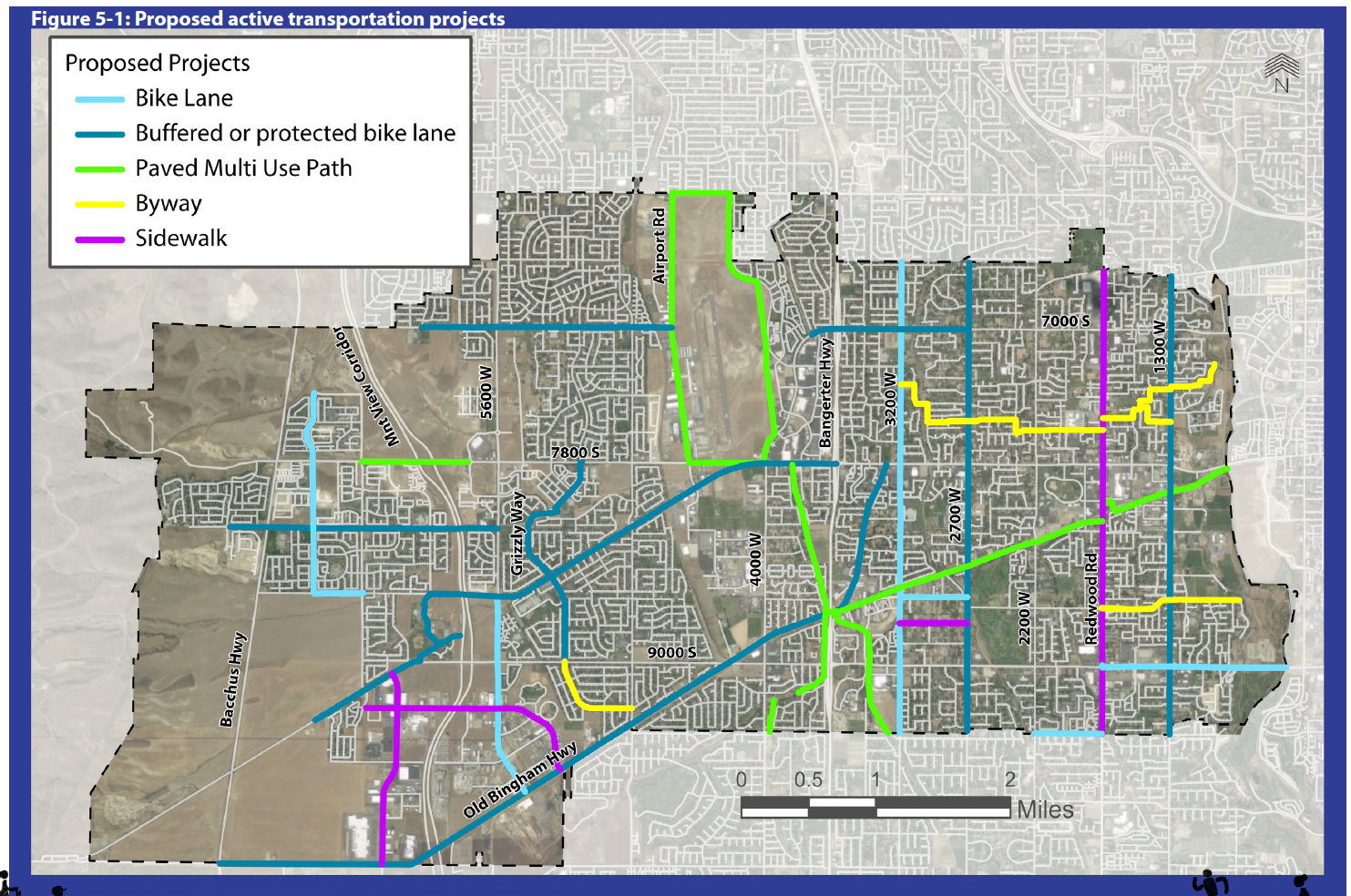
All new projects that were identified during public outreach efforts, such as the multi-use trail around the airport, were carried forward for future evaluation and ranking. Projects were developed and ranked jointly between West Jordan and South Jordan. Each individual city ranking maintains the same numbering that was assigned to the joint city list to ensure that the collective planning efforts do not become fragmented.
Active Transportation Cross-sections
The following graphics are from Salt Lake County's Bikeway Design guid- ance manual and show the types of bicycle infrastructure recommended in this document. The full Bikeway design guidance manual can be found at https://slco.org/globalassets/1-site-files/planning--transportation/files/slcobikewaydesign.pdf.

Bike lanes use signs and pavement markings to delineate street space that is exclusive for bicycling. Bike lanes can encourage predictable traffic flow from both cyclists and motorists.

Buffered bike lanes use painted buffers which improve bicyclist level of comfort by increasing the distance between traffic and cyclists. As with bike lanes, signs and pavement markings are to designate on-street space exclusive to bicycling.

Protected bike lanes, also known as separated bike lanes, are on-street or street-adjacent bikeways. They can be one-way or bidirectional facilities that are separated from traffic and walk- ways with vertical separation or physical elements such as parking, planters, or curbing. They are intended to provide the same level of comfort as shared-use paths and are similar to side paths but are exclusively for bicycle travel.

Multi-use paths, also known as shared-use paths, paved trails or greenways, are off street, paved facilities for bicyclists and pedestrians that are physically separated from motor vehicle traffic. These facilities are preferred by less experienced cyclists, but more experienced cyclists may avoid them due to out of direction travel and slower users.

Neighborhood byways also known as bicycle boulevards or greenways, are shared streets optimized for bicycle travel. Signs and pavement markings are used to create a high comfort environment while traffic calming features manage motor vehicle speeds and volumes.
While these designs are shown independently, they can, and should be integrated together along roadway(s) when it is necessary to do so. The choice of design treatment is dependent on both the comfort level and context of a specific area. For example, on a hilly road a striped bike lane may be needed alongside the lane that traffic ascends the hill due to the slower speed of the cyclist while they are climbing the hill. However, a shared use facility design, where cars and bikes are not physically separated, may be sufficient for the opposite, descending travel lane because the speed of the cyclist will be greater on the descent.
Prioritization Goals
Once projects were identified based on public and stakeholder outreach, prior plans, safety issues, and an analysis of gaps in the current network, the next step in the planning process was to determine which potential projects best meet the plan's goals. The end result of this prioritization process was a ranked list of projects, with the highest-ranked projects best meeting a set of criteria that reflect the values of West Jordan residents and stakeholders expressed they value in active transportation facilities.
Evaluation Criteria
Evaluation criteria were prepared based on collaborative discussion with the project team and stakeholder committee. Six major "themes" were identified. An overview of each theme, its measurable criteria, and the metrics that determine how each criterion was valued and integrated into the project's overall score is provided in Table 5-1.
∙ Feasibility reflects the ease with which a project can be implemented, and is weighted to favor projects that are lower in cost and overlap with planned roadway projects that may provide cost savings and reduced construction impacts.
∙ Connectivity reflects the degree to which projects provide a strong and complete network throughout West Jordan and South Jordan, including connecting to existing facilities and key destinations.
∙ Equity reflects a concern for providing access to all neighborhoods in the communities of West Jordan and South Jordan, especially areas that have not been well-served to date by active transportation facilities.
∙ Community Demand accounts for projects that address needs, desires, and safety issues raised by members of the public through outreach events and online surveys.
∙ Comfort prioritizes those projects that provide more protected and separated facilities, such as shared-use paths and protected bike lanes. This reflects a greater emphasis on providing facilities that are attractive to "interested but concerned" users who may be more sensitive to their proximity to motor vehicles.
∙ "Wow" Factor provides additional weight to projects that the Steering Committee has indicated will provide exceptional value to active transportation users in West Jordan and South Jordan. This factor is intended to provide greater prioritization to projects that can serve as a showcase for great infrastructure, provide an excellent experience for users, and help distinguish the communities as leaders in encouraging active transportation along the Wasatch Front.

Loading...