Loading...
Radioactive Material
Any material (solid, liquid, or gas) that emits radiation spontaneously. For the purpose of this definition, radiation means ionizing radiation, i.e., gamma rays and X-rays, alpha and beta particles, high-speed electrons, neutrons, protons, and other nuclear particles.
Recreational Vehicle (R.V.)
A unit designed to provide travelers’ accommodations built into, as an integral part of, or attached to a self-propelled motor vehicle chassis or drawn by a motor vehicle. The unit contains permanently installed independent support systems that provide at least four of the following facilities: cooking, refrigerator or ice box, self-contained toilet, heating, air conditioning, a portable water supply system including a faucet and sink, a separate 110-125 volt electrical power supply, or an LP gas supply.
Recreational Vehicle (R.V.) Space
An area within an R.V. park for the placement of an R.V. unit, in addition to any exclusive use area
to the unit set aside for the occupants of the R.V., such as a patio or vehicular space.
Regional Park System
Park land and associated recreational facilities and
to
-owned land used for active and passive recreational purposes for public use.
Regional Park (System) Improvements
Capital
that result in a net expansion of the park land or recreational facilities in regional parks that are available to the public. Remodeling, replacement or maintenance of existing equipment or facilities shall not constitute a regional park system improvement.
Rental Unit
One or more rooms in a Travelers’ Accommodation, Lodging, facility designed for occupancy by one or more
for compensation.
Repair (7A)
To mend, renovate, or restore a sign structure to its original existing condition.
Resource Corridor
An area running approximately parallel to the sides and banks of designated washes defined and characterized by the location of
associated with the wash, plus an area of 150 feet from the edge of the
on each side of the wash.
Revegetation
Establishment of plants at a
similar to what exists under similar topographic and soil conditions.
Rezone
To change the zoning classification of land.
Rhythm
The ordered recurrent alternation of solids to voids in the facade and streetscape.
Ridge
When used in relation to natural terrain, a relatively narrow elevation that is prominent on account of the steep angle at which it rises; an elongated crest or series of crests, with or without
, significantly higher than the
ground.
Ridge Line
A ground line located at the highest elevation of the
running parallel to the long axis of the
.
Right-of-Way
An area reserved for a public or private use, such as, but not limited to,
or
and utility easements.
Riparian
Land
to or within washes and drainageways that is occupied by biotic communities differing in species composition and/or
from surrounding upland due to an increase in moisture and different soil conditions.
Roadway
The paved portion of a
, excluding curbs. On an unpaved
, the
is the area set aside for motor vehicle traffic.
Roof Signs (7A)
Signs that are erected upon, against, or directly above a roof, or on top of or directly above the parapet of a building.
(Am. Ord. 11508, 12/5/2017)
Salvageable/Transplantable Plant
A plant rated as viable that also has a good likelihood of surviving and adapting to a new location if dug up and replanted.
Scenic Route
Any route designated as a Scenic Route in the
.
Screen
An
barrier designed and constructed to
areas used for storage, refuse, mechanical equipment, parking, or delivery service loading
from
and public view or to buffer
.
Search Area
As applied to wireless communication standards, the limited area within a
where an
can be placed that will provide satisfactory communications service within that
.
Seriously Mentally Ill
One as defined in A.R.S. § 36-550. The determination is to be made by an individual qualified in the State of Arizona to make such evaluation.
Service Area
As applied to wireless communication standards, the geographical area where satisfactory communications service can be provided by the placement of a specific
.
Service Bay
A specific location on a
reserved for servicing a motor vehicle. Such location can be within an
or can be a designated area located outside a
.
Service Radius Distance
Service radius distance is a measurable distance that is measured from a public facility (such as a park, fire station, police station, school, and related facilities) outward toward
that fall within the facility’s
.
Service Units
Vehicle-miles of travel and equivalent
.
Setback
The distance from a set point and is frequently used interchangeably with the term “
.” Setbacks may also pertain to drainage-related or other setbacks.
Short-Term Bicycle Parking Facility
A facility which provides a stationary object to which the operator can lock the frame and both wheels with a user provided U-shaped lock or a cable and lock.
Sidewalk
A constructed
meeting, at a minimum, the specifications for construction listed in this code or the Technical Manual.
Sidewalk Area
That portion of a
between the curb line or the lateral line of a
and the
, whether identified on the ground as a pedestrian walkway or not.
Sign (7A)
Every advertising message, announcement, declaration, display, illustration, insignia, surface or space erected or maintained in a location outside any building and visible to the public for identification, advertising or promotion of the interest of any person, entity, product or service.
Sign Copy (7A)
Any words, letters, numbers, figures, designs, or other symbolic representations incorporated onto the face of a sign.
Site
The land area consisting of a portion of a
, an entire
, or
, not including
public property, designated for
as a single entity.
Site Area
The land area of a
.
Site Coverage
The area of an overall
, inclusive of individual
, covered by such
as
, storage areas, and
. See Section 6.4.3,
and
Coverage, for the types of included and not included in the coverage calculation.
coverage, instead of , is used when calculating coverage limits for Flexible Lot Developments.
Site Plan
A drawing of a
that provides detailed information that shows how a proposed
will be developed in compliance with
regulations and other applicable regulations as required by outside review agencies involved in
review.
Site Utilization
The spacing between the sides of
.
Slope
An inclined ground surface the inclination of which is expressed as a ratio of horizontal distance to vertical distance.
Slope Plan
A plan that demonstrates the feasibility of complying with the
standards and
and
standards, and further depicts the location, extent, and treatment of all
and
.
Solar Access
Access to sunlight to protect active or passive
from shadows blocking exposure to the sun during hours of high insolation, from 9:20 a.m. to 3:20 p.m. local time.
Solar Energy System
Either or some combination of (1) a design using natural and architectural features to cool or heat a or (2) a mechanical assembly that may include a solar collector, storage facility, and any other components needed to cool or heat a .
Specific Plan
A detailed policy plan or regulation that implements the
or any of the elements of that Plan.
include subregional, area, and neighborhood plans; the
; the
; and any other similar plan.
Specified Anatomical Areas
Either the less than completely and opaquely covered human genitals, pubic region, buttock, anus, or female breasts below a point immediately above the top of the areola; or human male genitals in a discernibly turgid state, even if completely and opaquely covered.
Specified Sexual Activities
Include the following:
• Human genitals in a state of sexual stimulation or arousal;
• Acts of human masturbation, sexual intercourse, or sodomy; or,
• Fondling or other erotic touching of human genitals, pubic region, buttocks, anus, or female breasts.
Square Foot
The area of a square with sides of one foot in length.
Stacking Space
An area designed to accommodate vehicles waiting in line to receive a service.
Standards
Design principles, criteria, and specifications that describe the manner in which
and related
are accomplished in order to obtain
approval.
State
Same as the State of Arizona.
Status Offender
A youth of juvenile court age who is under the jurisdiction of a court for offenses that are unlawful for children but not unlawful for adults. It is the status of childhood that allows children to be status offenders.
Street
Any permanent public or private
, other than an
,
, or
, set aside to accommodate vehicular ,
, bike lanes, pedestrian facilities, utility areas, and other such design features, whether designated as a
, drive, highway, thoroughfare, road, boulevard, avenue, lane, or place.
Street Landscape Border
An area along the
of a
containing
, screening, and
, the purpose of which is to enhance the visual appearance of the streetscape.
Street Lot Line
The
bounding a
.
Street Perimeter Line
Same as
.
Street Yard
The yard between a
and a
.
Strip Easement
A utility easement running parallel with, and
, a
.
Structure
A physical element constructed or erected with a fixed location on the ground or attached to another physical element having a fixed location at, below, or above grade. Structures include such elements as, but are not limited to,
, paved areas, walls, fences, posts, and patios.
Structure Height
The vertical dimension of a measured from a specified point on the ground. For information on applying a height standards, refer to Section 6.4.4, Height.
Stub Streets
Dead-end
that are planned to be continued along the same alignment in a future
.
Subdivider
A
or other legal entity that files an application and initiates proceedings for the
of land in accordance with the provisions of this Article or any other local applicable ordinance or
statute, except that an individual serving as agent for such a
or other legal entity is not a subdivider. When applicable, the developer may be required to assume responsibility of the subdivider.
Subdivision
Any division of land, improved or unimproved, for the purpose of financing, sales, or lease, whether immediate or future, in one of four ways:
A. Any property whose boundaries are not fixed by a recorded which is divided into four or more
, , or
of land;
B. Any property that requires the
of a new
, which is divided into two or more
, , or
of land;
C. Any property whose boundaries are fixed by a recorded , which is divided into more than two parts; or
D. Any
, cooperative, community apartment, townhouse, or similar
containing four or more
, in which an undivided interest in the land is coupled with the right of exclusive occupancy of any unit located thereon, but
of such
need not show the
or the manner in which the
or airspace above the property shown on the
are to be divided.
Subdivision Improvements
include all
for the specific
, common areas, and
and other
needed for the individual
created by the .
also include the recording of full legal entitlements necessary for the functioning of the
such as easements, dedications or other binding legal documents.
on newly platted
are generally not considered part of the assurable
, unless determined by special conditions of the
.
(Am. Ord. 11200, 9/23/2014; Am. Ord. 11508, 12/5/2017; Am. Ord. 11803, 12/8/2020)
Tagging
The tagging of plants on-
to denote their identification number and their disposition, such as whether they will be preserved in place, salvaged and transplanted on-
, and/or salvaged and transplanted off-
.
Tandem Parking
Two
placed one behind the other with direct access from a
,
,
, or other to only one of the spaces. (See Illustration.)
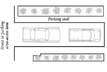
Tandem Parking
Temporary Sign (7A)
Any sign constructed of cloth, canvas, light fabric, cardboard, wallboard, plastic or other light material and not rigidly and permanently installed in the ground or attached to a building. Political election signs are not included in this definition.
Tenant (7A)
The occupant of a portion of a site or structure with exclusive control over that portion, regardless of whether it is by individual ownership or lease.
Terrace
A relatively level step constructed in the face of a graded
surface for drainage and maintenance purposes.
Tower
A mast, pole, monopole, guyed or freestanding framework, or other vertical element that acts as an
or to which an
is affixed or attached.
Tract
The same as “
.”
Travel Lane
The area within a paved
reserved for moving vehicular traffic.
Tucson General Plan
Same as
.
Turf
An area of grass ground cover grown together in a thick mat.
(Am. Ord. 11508, 12/5/2017)
Undisturbed Natural Desert
An area of land maintained in its original condition with natural desert cover, native topography, and
intact.
Unified Development Code (UDC)
Chapter 23 of the Tucson Code as adopted by the Mayor and Council establishing zoning regulations governing the use, placement, spacing, and size of land and
within the corporate limits of the
. Such regulations are applied on individual properties through the use of
. The boundaries of these districts are depicted on the adopted
. For the purposes of convenience and ease of use, the
is also published as a separate book from the Tucson Code.
Unoccupied (7A)
A premises or structure:
A. That is not occupied, or
B. That is not being put to those uses authorized by the last business privilege license issued by the City of Tucson for that address and business, or
C. Where the public utilities are not in service.
Upland Vegetation
Refers to vegetation that grows outside of the floodplain, typically on low desert
. Upland vegetation on south-facing
typically includes the Foothill Palo Verde, Saguaro, and Ocotillo; on north facing
, it typically includes the Foothill Palo Verde and Whitethorn Acacia. Some plants, such as Mesquites, are able to grow as upland and
vegetation.
Urban Agriculture
The practice of producing food locally through the cultivating, processing, distributing, selling, or
of agricultural products and other related activities in the
and may involve horticulture, aquaculture, and
husbandry.
Utilities
Services such as gas, electric, water, telephone, and cable television.
(Am. Ord. 11328, 12/8/2015; Am. Ord. 11508, 12/5/2017)
Loading...