Loading...
A. Purpose. The -L overlay zone is intended to identify landmarks and historic sites in compliance with the General Plan, so that development and new land uses are designed and operated in a manner compatible with the preservation of these resources.
B. Applicability. The -L overlay zone may be combined with any primary zoning district established by Section 19.40.010.
C. Allowed Land Uses and Regulations. Any land use normally allowed in the primary zoning district by this division may be allowed within the -L overlay zone, provided that the use complies with Chapter 19.37 of this code.
D. Permit Requirements - Certificate of Appropriateness and Certificate of Demolition. A certificate of appropriateness and certificate of demolition shall be required pursuant to Chapter 19.37.
E. Development Standards. Proposed development and new land uses within the -L overlay zone shall comply with the development standards of the primary zoning district, all other applicable provisions of these Regulations, and any conditions of approval providing measures to preserve and protect existing resources. Any deviations from the development standards necessary to ensure retention of the historical attributes of a structure or building may be made pursuant to section 19.37.140 of this code.
(Ord. 2185; Ord. 2410 §17, Ord. 2427 §39)
A. Purpose. The purpose of the -PD overlay zone shall be as set forth in Section 19.28.010 of this Code.
B. Applicability. The -PD overlay zone may be combined with any residential, commercial, or manufacturing/industrial zoning district established by Section 19.40.010.
C. Allowed Land Uses. Any land use normally allowed in the primary zoning district may be allowed within the -PD overlay zone, except when the ordinance rezoning a site to the -PD overlay zone includes specific limitations on allowable land uses, or a planned development permit issued in compliance with Chapter 19.28 and Subsection D below includes specific limitations on allowable land uses.
D. Permit Requirements. The first development of a vacant site in the PD overlay zone or any new construction on a developed site in the PD overlay zone shall require planned development permit approval for any allowed use. Thereafter, changes in the use of existing structures shall require land use entitlement approval in compliance with the primary zoning district, except where an approved planned development permit establishes different permit requirements for changes in land use.
E. Development Standards. Standards for development of properties in the -PD overlay zone shall be as set forth in Section 19.28.040 of this Code.
(Ord. 2185; 2382 §8. Ord. 2427 §40)
A. Purpose. The -RC overlay zone is intended to identify areas with significant environmental resources that result in development constraints. The -RC overlay zone requires subsequent studies and coordination with resource agencies to determine the exact location of sensitive environmental features or species, and the scope of development that can take place in light of these environmental constraints. The -RC overlay zone is also intended to maintain a sustainable environment consistent with existing biotic resources, soils, geology, topography, and drainage patterns, and avoid development that would result in adverse or unmitigated environmental impacts.
B. Applicability. The -RC overlay zone may be combined with any primary zoning district and applies to areas designated by the General Plan as Resource Constraint Overlay (RCO).
C. Allowed Land Uses. Any land use normally allowed in the primary zoning district may be allowed within the -RC overlay zone.
D. Permit Requirements. Planned development permit approval shall be required in compliance with Chapter 19.28 for all new or expanded uses if no other discretionary approval is required.
E. Development Standards. Proposed development and new land uses within the -RC overlay zone shall comply with the development standards of the primary zoning district, all other applicable provisions of these regulations, any conditions of approval providing measures to preserve and protect existing resources, and the following.
1. Subdivisions. Subdivision of land shall not be permitted except in compliance with required environmental mitigation measures for resource preservation and protection. Proposed lots or parcels shall be clustered where necessary to preserve and protect identified resources.
2. Minimum Lot Area, Maximum Number of Housing Units. The commission may approve a subdivision including parcels smaller than those required by the primary zoning district through the planned development permit process.
3. Limitations on Grading. No grading permit shall be issued and no grading shall occur on a site within the -RC overlay zone until a land use entitlement or subdivision approval for a project has been granted.
4. Modification of Standards. The commission may waive or modify the development standards of the primary zoning district through the planned development permit process in compliance with Chapter 19.28 where necessary for resource preservation and protection.
(Ord. 2185, Ord. 2427 §41)
A. Purpose. The -SD overlay zone is intended for areas of the City where the General Plan has highlighted existing neighborhood characteristics, environmental features, or other concerns that require special attention in project design.
B. Applicability. The -SD overlay zone may be applied to specific, defined areas where special-purpose limitations on land use, permit requirements, or development standards are needed. The -SD overlay zone includes the specific subcategories identified in Subsection D, following.
C. Allowed Land Uses. Any land use normally allowed in the primary zoning district by this article may be allowed within the -SD overlay zone, except where otherwise limited by this section.
D. Specific Area Permit Requirements and Development Standards. Development and new land uses within the -SD overlay zone shall obtain the land use entitlements as required by the primary zoning district, except as otherwise provided in this subsection, and shall comply with all applicable development standards of the primary zoning district, and the following requirements.
1. SD-1 (South Chico - South of Entler Avenue).
a. Permit Requirement. Planned development permit approval (Chapter 19.28) is required for all uses.
b. Clustering Required. Manufacturing/industrial development in the area west and east of State Highway Route 99 south of Entler Avenue shall be clustered to preserve existing riparian habitats and to reduce impacts to Butte Creek.
c. Tree Preservation Required. The existing cottonwood and native oak stands located west of State Highway Route 99 and along the south edge of this area shall be preserved to the extent feasible.
2. SD-2 (Humboldt Road-Foothill).
a. Permit Requirement. Planned development permit approval (Chapter 19.28) is required for all uses.
b. Development Standards. Proposed projects shall:
(1) Minimize the visual impact of foothill development through the following measures:
(a) Transfer and cluster development to lower elevations of the site and cluster development at higher elevations to the least visible areas;
(b) Reduce the scale and mass of structures through split level and low profile design. Limit building heights in foothill areas to 25 feet, unless visual simulations or other graphic representations can verify that greater building height will not negatively impact the viewshed;
(c) Use low-level pedestrian-scale street lighting;
(d) Avoid the use of high illumination yard lighting or shield sources to prevent off-site glare;
(e) Blend development into the natural setting through attention to topography and orientation, color, materials;
(f) Incorporate street standards that minimize cut and fill and result in the lowest visual impact;
(2) Provide a minimum 50-foot setback from State Highway Route 32 and prepare and implement a landscape enhancement plan for the setback area and the adjacent Caltrans right-of-way. The plan shall use vegetation native to the area and an irrigation system designed to temporarily provide water through the plant establishment period;
(3) Preserve and improve multi-use access and trails along Humboldt Road and provide connection to other paths and trails within projects north and south of Humboldt Road;
(4) Preserve the existing historic rock wall;
(5) Reduce wildland fire potential through the following:
(a) Construct buildings and roofs from fire-resistant materials;
(b) Landscape with native fire-resistant plant materials;
(c) Provide multi-use access and trails, streets, and open space areas as opportunities for emergency access and fire breaks;
(d) Ensure that street grades and other facilities designed for emergency access do not exceed City maximums;
(e) Locate buildings for maximum clearance from areas of dense native vegetation; and
(6) Incorporate best management practices for storm water run-off and first flush treatment of storm water. Proposed projects in areas tributary to Little Chico and Comanche Creeks shall be designed to provide no net increase in peak storm water run-off.
3. SD-3 (Foothill Park East, South of Eaton Road)
a. Permit Requirement. Architectural Review and Historic Preservation Board approval (Chapter 19.18) is required for multi-family residential development.
b. Development Standards.
(1) Density shall not be less than 10 units per gross acre.
(2) Design shall be consistent with the Master Design Manual for Foothill Park East.
(3) The project shall incorporate low profile lighting for reduced glare on adjacent properties.
(4) For the parcel east of Marigold Avenue and identified as APN 016-200- 102, the Architectural Review and Historic Preservation Board shall require a pedestrian/equestrian path within or adjacent to the public utility easement along the southern property boundary with access to the south. Alternatively, the ARHPB shall waive this requirement if a path is already provided at that proximate location, or if the improvement is determined to be infeasible.
4. SD-4 (West Avenue Neighborhood Area). Any declaration of restrictions regarding owner occupancy recorded prior to January 1, 2020 in conjunction with the development of an accessory dwelling unit shall remain valid and binding.
5. SD-5 (Westside Place & Vrisimo; Three Parcels on the North side of State Highway Route 32/Nord Avenue between W. 8th Avenue and W. Lindo Avenue)
a. Permit Requirement. Planned development permit (PDP) approval (Chapter 19.28) is required for all developments.
b. Development Standards. To ensure appropriate safety, environmental, and aesthetic requirements of the local community given the site’s location between a public highway and the railroad tracks, future developments shall include the following design concepts:
(1) Overall minimum residential density on each of the three parcels shall be 9 units per gross acre.
(2) A mix of housing types and appropriately designed commercial and/or live-work buildings along the railroad tracks to provide an adequate noise buffer for adjacent residential uses.
(3) Multi-family units shall be limited to buildings of modest scale with architectural details similar to neighboring detached houses.
(4) Street and pedestrian connections shall be provided between adjacent developments.
(5) A side drive with a landscaped parkway strip shall be incorporated between the development and Nord Avenue/State Highway Route 32.
(6) Off-street parking shall primarily be provided off an alley or common driveway. Parking off a front yard shall be designed so that the building creates the dominant visual appearance along the street.
6. SD-6 (Chapman/Mulberry Neighborhood)
a. Development shall be consistent with the Chapman/Mulberry Neighborhood Plan adopted by the city council.
b. The following land uses are not permitted within the CN zone: retail liquor stores, gas stations, automobile sales and vehicle repair and maintenance.
c. The following design standards shall apply to the development of single- family residences:
(1) Front yard setbacks shall be consistent with the average of the existing front yard setback of adjoining parcels, but in no case less than fifteen (15) feet or greater than thirty (30) feet.
(2) Front entries for all single-family residences shall be oriented toward the street. This requirement shall not apply to accessory dwelling units located on the rear of a parcel which have primary access from an alley.
(3) Garages shall be set back at least ten (10) feet from the front edge of the dwelling. Garages located in rear yards are encouraged. Detached, single- story garages shall be set back at least five (5) feet from the rear property line.
(4) All single-family dwellings shall include a front porch with minimum dimensions of four feet by eight feet.
(5) Front yard fences are permitted only when they are of an open, not solid, design. Front yard landscaping shall not obscure views of the street or adjoining neighbors.
(6) One new tree, 15 gallons or greater in size, shall be planted in the front yard of each new single-family residence, as a condition of the building permit for such residence. The species of tree planted shall be selected from the list “Recommended Street Trees for Chico” maintained by the City.
d. The following design standards shall apply to the development of multi-family dwellings:
(1) Parking lots shall primarily be located in the rear or side area of the parcel or in the interior of a building cluster and shall be screened from view from the street by vegetation or fencing that is no more than four feet in height. No parking lots shall be located within the required front or side set back area.
(2) All multi-family buildings located within 40 feet of a front lot line shall be oriented to the street frontage. The main entrance of ground floor units located within 40 feet of a street must face the front lot line. Main entrances may be to either individual units, clusters of units or common lobbies or courtyards. Main entrances for multi-family residences on corner lots may be oriented toward either street frontage, or toward the corner.
(3) Pedestrian walkways shall be provided from street sidewalks to the front entrance of each multi-family dwelling unit.
e. It shall be a condition of the development of any new commercial or industrial use located on property which abuts residentially zoned property, that an 8 foot masonry wall be constructed between the new commercial or industrial use and the residentially zoned property. Such wall shall be constructed on the property on which the new commercial or industrial use is located and shall include landscaping along the side of the wall facing the residentially zoned property. Earthen landscape berms with a wall may be utilized to meet this requirement.
f. A nonconforming commercial or industrial use shall not be expanded, enlarged, or extended. If a structure used for a nonconforming commercial or industrial use is destroyed or demolished, regardless of cause, or the nonconforming use thereof is abandoned for six months or more, or is converted to or replaced by a conforming use, the right to continue the nonconforming use therein shall cease.
g. Nonconforming uses shall be amortized as follows:
(1) Nonconforming commercial and industrial uses which were located in the City prior to the date of the City’s adoption of the Chapman/Mulberry Neighborhood Plan on October 5, 2004, shall be amortized and terminated no later than December 31, 2014.
(2) Nonconforming commercial and industrial uses which are annexed into the City after adoption of the Chapman/Mulberry Neighborhood Plan on October 5, 2004, and which were nonconforming prior to annexation pursuant to the land use regulations of Butte County, shall be amortized and terminated no later than three years after the date the property on which the use is located is annexed into the City. Requests to extend the time period by which such a nonconforming use must terminate may be made to the planning commission and may be granted only for good cause upon consideration of the following factors.
a. The total cost of the property and lawfully installed or constructed improvements.
b. The depreciated value of the property.
c. The remaining useful life of the improvements.
d. The original length and remaining term of the lease, if any, under which the premises is occupied.
e. The percentage of the business conducted on the premises compared to the percentage conducted elsewhere.
f. The cost of moving and reestablishing the business elsewhere.
g. The nature and extent of efforts made by the owner or operator of the nonconforming use to relocate and/or reestablish the use in a properly zoned location.
h. The nature of the nonconforming use, as compared to the character of the surrounding neighborhood.
i. The harm to the public if the use remains beyond the amortization period.
j. The feasibility of converting the use of the premises to an allowed use or a use allowed with a use permit.
k. Other related factors.
Extension requests must be submitted no later than two years before the date the nonconforming use is required to be terminated. Such applications shall be on a form approved by the director and must include the information pertaining to all of the above factors which the applicant believes are applicable to the request. The Planning Commission shall act on all requests for an extension after holding a public hearing and may condition any extension granted as it deems necessary to reduce impacts from the nonconforming use on the surrounding neighborhood. The public hearing shall be noticed and held in the same manner as public hearings for use permits.
For properties on which a nonconforming commercial or industrial use exists at the time they annexed into the City, extension requests must be submitted no later than one year after the date that the property is annexed into the City. Such applications shall be on a form approved by the director and must include the information pertaining to all of the above factors which the applicant believes are applicable to the request. The Planning Commission shall act on all requests for an extension after holding a public hearing and may condition any extension granted as it deems necessary to reduce impacts from the nonconforming use on the surrounding neighborhood. The public hearing shall be noticed and held in the same manner as public hearings for use permits.
(3) Nothing in this paragraph g. shall preclude the conversion of a nonconforming use to a lawful use if: 1) the nonconforming use could be permitted with a use permit; 2) a use permit is obtained; and 3) the use is thereafter conducted in conformance with the terms and conditions of the use permit and all applicable provisions of this code.
7. SD-7 (Cactus Avenue)
a. The following design standards shall apply to all new development:
(1) Street connectivity shall be provided between developments consistent with Community Design Element policies of the General Plan, including provisions for connections to Cactus Avenue and Arch Way. Vehicular access onto Cactus Avenue shall only be allowed at such time that Cactus Avenue is improved between the access point to Cactus Avenue and East Avenue.
(2) Lots fronting Cactus Avenue shall have a minimum lot size of 10,000 square feet.
(3) Homes fronting Cactus Avenue shall be oriented to face Cactus Avenue and may have driveways onto Cactus Avenue.
(4) Buildings on parcels fronting Eaton Road shall face Eaton Road, unless otherwise provided by Planned Development Permit, and shall address potential noise concerns with measures that avoid the use of sound walls.
(5) Low-level street lighting shall be utilized to maintain the rural atmosphere of the area.
(6) All future subdivision applications shall require a Planned Development Permit.
8. SD-8 (Southwest Chico Neighborhood)
a. The following design standards shall apply to the construction of new single-family residences and/or accessory structures:
(1) Front yard setbacks shall be consistent with the average of the existing front yard setback of adjoining parcels, but in no case less than fifteen (15) feet or greater than thirty (30) feet.
(2) Front entries for all new single-family residences shall be oriented toward the street.
(3) Garages shall be set back at least ten (10) feet from the front edge of the dwelling. Garages located in rear yards are encouraged. Detached, single-story garages shall be set back at least five (5) feet from the rear property line.
(4) All new single-family dwellings shall include a covered front porch with a minimum area of forty (40) square feet.
(5) Front yard fences are permitted only when they are of an open, not solid, design. Front yard landscaping shall not obscure the views of the street or adjoining neighbors.
(6) One new tree, fifteen (15) gallons or greater in size, shall be planted in an existing parkway strip of each new single-family residence as a condition of the building permit for such residence, if no tree already exists. The species of tree planted shall be selected from the list "Recommended Street Trees for Chico" maintained by the City Urban Forest Manager, and installed in accordance with Standard Plan LS-1 in Title 18R.
(Ord. 2185; Ord. 2222; Ord. 2263; Ord. 2301 §4; Ord. 2306; Ord. 2328, Ord. 2346, Ord. 2427 §42, Ord. 2429 Ord. 2435 §30, Ord. 2439 §179, Ord. 2440 §34, Ord. 2511, §11, Ord. 2530, §3, Ord. 2549, §7)
A. Purpose. The -COS overlay zone is intended to encourage mixed use development of medium- and high-density residential and commercial land uses and to promote increased residential density, and transportation patterns that do not rely solely on the automobile. The development standards of the -COS overlay zone are designed to encourage a safe and pleasant pedestrian environment with an attractive streetscape, and limited conflicts between vehicles and pedestrians.
B. Applicability. The -COS overlay zone is applied to land designated by the General Plan as either a corridor opportunity site or a downtown opportunity site.
C. Allowed Land Uses. Allowed land uses are determined by the primary zoning districts. Residential projects within the -COS must be developed at or above the midpoint of the allowable density range of the primary zoning district designation unless one or more of the following findings are made:
1. The proposed project does not include residential development;
2. Residences are integrated vertically in a mixed-use project;
3. Site considerations such as parcel size, configuration, environmental resources, or other features make achieving the midpoint infeasible or undesirable; or
4. Infrastructure constraints make achieving the midpoint impractical.
D. Development Standards. In addition to the standards of the primary zoning district and all other applicable provisions of these regulations, the following criteria apply:
1. Density. When associated with a residential base zoning district: 15 units/acre minimum, 70 units/acre maximum. When associated with an office or commercial base zoning district: Up to 60 units/acre.
2. Maximum Height Limit: 65 feet and unless the underlying zoning district permits a greater maximum height.
3. Off-Street Parking Reduction. Proposed development may provide off-street parking at a lower rate as provided by Chapter 19.70.
(Ord. 2185, 2427 §43, Ord. 2494 §31, Ord. 2600)
A. Purpose. The purpose of the -FS overlay zone is to encourage fraternity and sorority houses, as defined by Section 19.04.020, to be located in proximity to the California State University, Chico, campus and to preserve the neighborhood characteristics of the area.
B. Applicability. The -FS overlay zone may be combined with the R3, R4, and RMU residential zoning districts.
C. Allowable Land Uses. Any land use normally allowed in the primary zoning district may be allowed within the -FS overlay zone, subject to the land use permit requirements of the primary zoning district, except that fraternity and sorority houses shall be a permitted use upon the issuance of a fraternity/sorority house permit by the Director in compliance with Chapter 19.21 (Fraternity and Sorority House Permits).
(Ord. 2427 §43)(Ord. 2435 §31, Ord. 2494 §32)
A. Purpose. The purpose of the -FD overlay zone is to prevent environmental degradation, slope failure, increased erosion, sedimentation, and stormwater run-off; to preserve natural conditions in areas visible from public spaces; to retain topographic features and vegetation; to require site specific design solutions for unique topographic, landscape, and geotechnical settings; and to implement General Plan policies that apply to foothill development.
B. Applicability. The -FD overlay zone may be combined with any primary zoning district established by Section 19.40.010. The -FD overlay zone shall be applied and as shown on the Zoning Map for those properties at an elevation of 270 feet or greater.
C. Allowable Land Uses. Any land use normally allowed in the primary zoning district may be allowed within the -FD overlay zone.
D. Permit Requirements. Foothill development permit approval shall be required as set forth in Section 19.27.010. The requirements in Subdivisions (G) and (H) of this Section shall apply to projects for which a foothill development permit is required. They do not apply when a foothill development permit is not required.
E. Basis for Slope Determinations. For the purpose of this section, slope shall be computed on the natural slope of the land before any grading is commenced, as determined from a topographic map having a scale of not less than 1 inch equals 100 feet and a contour interval of not more than 5 feet.
F. Development Standards for Projects Within the -FD Overlay Zone. The following development standards apply to all projects within the -FD Overlay Zone.
1. Structure Height. Height shall be measured as the vertical distance to an imaginary plane located above the natural (pre-development) grade (See Figure 4-1). The height limit in the -FD overlay zone is 25 feet, with an allowance of up to 5 additional feet for chimneys, vents, other projecting architectural features, water tanks, and renewable energy devices. Heights less than 25 feet may be required along ridgelines and where prominently visible from public rights-of-way, parks, and other public spaces. Heights up to 35 feet may be allowed if the additional height does not impact public viewsheds.

2. Height measurement on downhill lot. Where the average slope of a parcel is greater than a 1-foot rise or fall in 7 feet of distance from the street elevation at the property line, one story shall be allowed on the downhill side of any structure in addition to the height allowed by the applicable zoning district; provided that the height of the structure shall not be increased above the limit established by the zoning district, measured from the finished street grade to the top of the roof (See Figure 4-2).

3. Setbacks Between Structures and Toes/Tops of Slopes.
a. On adjacent lots having a difference in finished grade elevation of 3 feet or more, the side yard shall be measured from the toe or top of slope to any structure, whichever is nearer.
b. On adjacent lots having a difference in finished grade elevation of 6 feet or more, the minimum distance between the toe or top of the slope, whichever is nearer, and any main structure shall be 15 feet.
c. The grading standards of Title 16 R (Building Standards) shall also apply and may result in greater setback requirements.
4. Clustered Development. In clustered development, dwelling units shall be grouped on more level or gently sloping terrain so as to reduce grading alterations on steeper slopes that shall be preserved in a natural state.
5. Maximum Density Calculation. To retain the natural features of hillsides, densities shall be reduced as slope increases. Each property to be developed shall be divided into cells of similar slope, using the average slope ranges listed in Table 4-16. The maximum density of the base zoning is then multiplied by the relevant reduction factor assigned to each cell to determine the maximum allowable density for each cell.
Average Slope Range | Density Reduction Factor |
0% to 10% | None |
10.1% to 15% | 0.9 |
15.1% to 20% | 0.8 |
20.1% to 25% | 0.6 |
25.1% to 30% | 0.4 |
Greater than 30% | No development |
6. Exterior Lighting. Lighting for new project sites and new streets shall be shielded to avoid glare and the spill of light to surrounding areas. Street lighting shall consist of multiple, shielded, low-intensity, pedestrian-scale lighting fixtures instead of fewer, taller fixtures.
7. Retaining Walls. Large retaining walls shall be broken into elements and terraces to avoid creating a uniform plane and landscaped to screen them from view (See Figure 4-3).

8. Street Design.
a. Street Layout. Streets shall follow the natural contours of the terrain, where possible, to minimize the need for grading. Cul-de-sacs and loop roads should be used where necessary to fit the natural contours and topography, subject to the approval of the City Engineer and Fire Department.
b. Reduced Street Widths. Streets may be designed without parking lanes when the result is a substantial decrease in cutting and/or filling. Streets may be reduced as provided for in Title 18R, Design Criteria and Improvement Standards.
9. Site and Structure Design. Site and structure design shall visually blend structures with the surrounding terrain.
a. Lot Line Locations. Lot lines should be placed at the top of slope areas.
b. Location of Structures. Structures should be sited in a manner that will:
(1) Minimize the creation of flat pads by using compact, split-level designs;
(2) Preserve vistas from public places; and
(3) Preserve visually significant rock outcroppings, natural hydrology, native plant materials, and areas of visual significance.
c. Architectural Design. Buildings shall demonstrate the following design principles:
a. Building scale that complements the character of the foothills and avoids massive forms that dominate public views of the foothills.
b. Varying setbacks, building heights, foundation designs, building forms, materials, and colors that blend structures into the terrain.
c. Building facades with varied planes and overhangs as a means to create changing shadow lines that further break up massive forms.
d. Incorporation of single story elements, setbacks, roof pitches, and landscaping for wall surfaces facing public viewsheds (See Figure 4-4).

e. Roof pitches placed to generally follow the angle of the slope, but with variation to avoid a monotonous appearance.
f. Medium to dark earth tone colors used for building elevations and roof materials.
g. Surface materials to blend with the landscaping and natural vegetation, such as textured stucco, wood, natural brick, and coarse block.
h. Rough-textured roof materials (and in some cases terra cotta and metal) in a muted, darker tone, including browns, grays and greens.
10. Grading and Drainage.
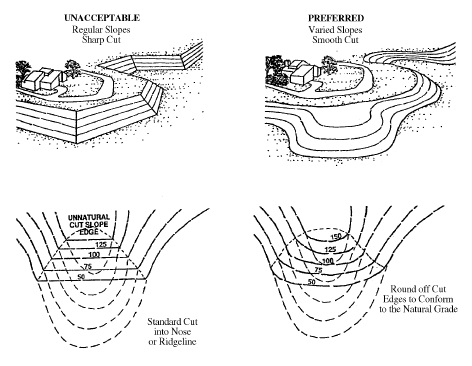
a. Grading shall be designed to conserve natural topographic features and appearances by retaining major natural topographic features (for example, canyons, knolls, ridgelines, and prominent landmarks), by minimizing the amount of cut and fill, and by means of landform grading to blend graded slopes and benches with the natural topography (See Figure 4-5).
b. Grading plans shall identify slopes that are to be landform graded. "Landform grading" shall mean a contour grading method that creates artificial slopes with curves and varying slope ratios in the horizontal plane designed to simulate the appearance of surrounding natural terrain.
c. All graded areas shall be protected from wind and water erosion, in compliance Titles 16 (Buildings and Construction) and 16R (Building Standards). Interim erosion control plans, certified by the project engineer, shall be required.
d. Exposed slopes shall be replanted with non-invasive but self-sufficient trees, shrubs, and groundcover that are compatible with existing surrounding vegetation, to help blend manufactured and natural slopes and to protect slopes from soil erosion.
e. Grading that would create a slope exceeding a ratio of 3:1 requires a report and a stabilization study that indicates a greater permissible slope, unless it is determined by the Director that site conditions (as supported by data) do not warrant the report and study.
G. Required Plans and Reports. A subdivision or land use entitlement application for a site within the -FD overlay zone shall include the following documents as determined by the Director. If an applicant believes that any or all of the documents are not applicable, a written justification supported by factual information shall be submitted to the Director in order to justify an exception.
1. Topographic Map. A topographic map of the project site and land and structures within 100 feet of the project boundaries. Section drawings and/or elevations may be required where necessary to indicate those residences which may be affected in terms of view obstruction. The map shall be drawn to a scale of not less than 1 inch = 100 feet, with a maximum contour interval of 5 feet;
2. Project Plans. Plans of the proposed project, including property lines with recorded and proposed easements and public rights-of-way, existing and proposed contours, a representative cross-section showing existing and proposed conditions, ridgelines if applicable and the proposed treatment thereof, proposed erosion control and/or slope stabilization techniques, structure siting criteria and/or building envelopes, any height limitations, and any solar orientation considerations;
3. Slope Maps. Maps of existing and final slope depicting the following slope categories: 0-5 percent, 6-10 percent, 11-15 percent, 16-20 percent, and 21+ percent;
4. Soils Report. A soils engineering report, including data on the nature, distribution, and strengths of existing soils, approximate depth and location of shallow impervious layers; subsurface drainage; design criteria for identified corrective measures; and recommendations regarding existing conditions and proposed grading. The report shall be prepared by a registered engineer;
5. Geology Report. A geology report, including the surface and subsurface geology of the site, degree of seismic hazard, recommendations regarding the effect of geologic conditions on the proposed development, and recommended design criteria to mitigate any identified geologic hazards. The report shall be prepared by a registered geologist, civil engineer, or other qualified professional in engineering geology and may be combined with the soils report;
6. Hydrology Report. A hydrology report that identifies areas of possible inundation, downstream effects, natural drainage courses, primary groundwater recharge areas, effect of hydrologic conditions on the proposed development, recommendations regarding the adequacy of proposed facilities, and proposed solutions to mitigate identified hydrologic hazards. The report shall be prepared by a registered civil engineer experienced in hydrology and hydrologic investigation;
7. Biological Resource Assessment. A biological resource assessment of the subject site by a qualified biologist, including the location and species of trees over six inches in diameter at breast height; habitat type, such as annual grassland, permanent wetland, vernal pools/seasonal wetland or valley oak woodlands; and the occurrence of any special status species within the area;
8. Preliminary Landscaping Plan. A preliminary landscaping plan showing the size and location of existing trees over six inches in diameter at breast height, indicating any trees proposed for removal, and the type and extent of proposed conceptual landscaping;
9. Visual Simulation. A realistic, three-dimensional computer simulation of the proposed structures from multiple view points, including the use of story pole plans for structures along ridgelines or visible from public spaces; and
10. Other Information. Other information or application materials as may be deemed necessary by the Director.
H. Project Evaluation. The review authority's consideration of an application for foothill development shall include an evaluation of the following:
1. Consistency with the foothill development standards listed in this section;
2. The retention of natural topographic and prominent landmark features, significant ridgelines, natural rock outcroppings, prominent trees and woodlands, and other areas of special natural beauty; and
3. Site planning and structure design that minimizes impacts to public viewsheds.
(Ord. 2440 §36, Ord. 2494 §33, Ord. 2550 §2)
A. Purpose. The purpose of the -VE overlay zone is to implement the Valley's Edge Specific Plan.
B. Applicability. The -VE overlay zone may be combined with any primary zoning district established by Section 19.40.010 that exists within the bounds of the Valley's Edge Specific Plan area.
C. Allowable Land Uses. Land use allowances within the Valley's Edge Specific Plan area shall be determined as set forth in Appendix C of the Valley's Edge Specific Plan (Permitted and Conditionally Permitted Uses). If the Specific Plan is silent regarding a particular land use, then these Regulations shall be used to determine permitted land uses and permit requirements.
D. Development Standards. The development standards applicable to sites within the -VE overlay zone shall be as set forth in the Valley's Edge Specific Plan. If the Specific Plan is silent regarding a particular development standard, then these regulations shall be used to determine permitted land uses and permit requirements.
E. Administration and Permit Procedures. The administration and permit procedures contained in Divisions II and III, respectively, of these regulations shall be used to administer and process entitlement requests within the Valley's Edge Specific Plan area.
(Ord. 2583, §2)