CHAPTER 10
DOWNTOWN ANTIOCH FORM BASED CODE
DOWNTOWN ANTIOCH FORM BASED CODE
SECTION:
10-10-1: Introduction
10-10-2: Regulating Framework Plan
10-10-3: Uses; Height; Parking And Servicing
10-10-4: Zoning Districts
10-10-5: Village Core District - VC
10-10-6: Transitional Core District - TC
10-10-7: Main Street Transitional District - MT
10-10-8: Business Park District - BP
10-10-9: Commercial Edge District - CE
10-10-10: Urban Design Standards
10-10-10-1: Building Design
10-10-10-2: Streetscape/Landscape
10-10-11: Building And Ground Mounted Signage
10-10-12: Sustainable Development Policy
The intent of this downtown Antioch form based code is to help set the foundation for a set of guiding principles that will foster a vibrant, pedestrian friendly, mixed use, transit oriented downtown. This chapter will outline and establish new development regulations for streets, blocks, and buildings that emphasize "building form", "public realm" and high quality site and building design in each of the distinct downtown districts.
This chapter shall act as a component to this title and shall be administered pursuant to the ordinances and regulations of the village of Antioch in compliance with the laws and statutes of the state of Illinois.
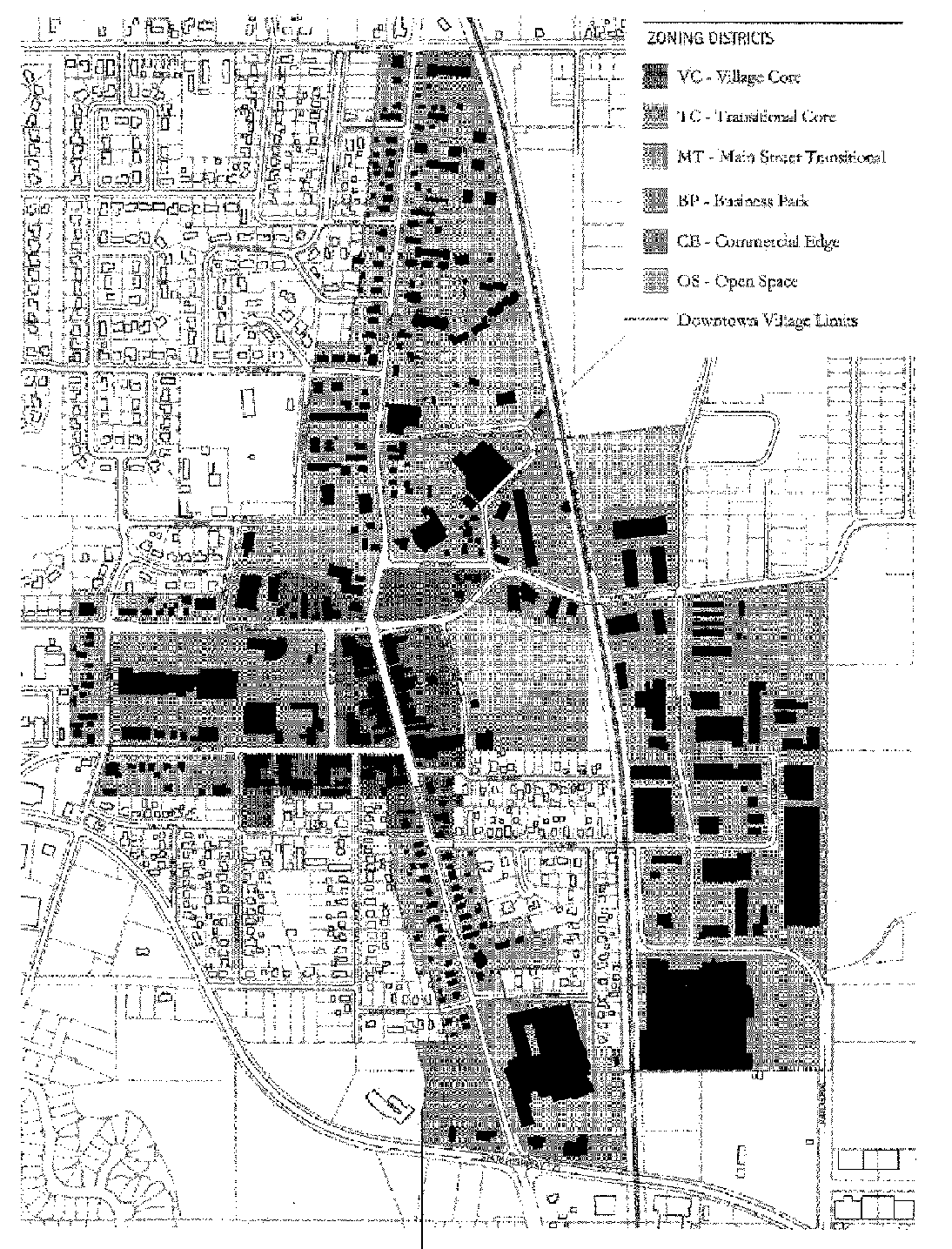
In order to clearly organize this chapter, a regulating plan has been developed (see figure 1.1 of this section). The downtown Antioch regulating plan outlines five (5) distinct character districts within the greater downtown area. These districts include:
Village core (VC)
Transitional core (TC)
Main Street transitional (MT)
Business park (BP)
Commercial edge (CE)
Additionally, areas of open space (OS) are found throughout the downtown area. While not its own unique district, preservation, enhancement and improvement to existing and new open spaces should be provided throughout downtown Antioch.
A more detailed discussion, illustrations of future target development sites and urban design standards are addressed in the following sections. Additionally, an outline of permitted and special land use categories is included per district.
FIGURE 1.1
DOWNTOWN ANTIOCH REGULATING PLAN
DOWNTOWN ANTIOCH REGULATING PLAN
(Ord. 11-10-15, 10-17-2011)
A. Purpose: The regulating framework plan defines the desired physical form for downtown Antioch and sets development/building parameters such as land use, building height, massing, siting and setbacks and parking placement and ratios. This chapter incorporates not only the vision of the regulating plan, but also applies to, and regulates, parcels not specifically referenced in the plan.
Figure 2.1, "Downtown Antioch Target Opportunity Sites", of this section highlights downtown opportunity sites identified in the transit oriented planning/design process. For illustrative purposes, figures 2.2 and 2.3 of this section show the potential desired build out of these sites. These plans reflect the goals and objectives of the regulating plan and serve as a guide for village officials, property owners, and developers as they move forward with approving and implementing these projects within downtown.
FIGURE 2.1
DOWNTOWN ANTIOCH TARGET OPPORTUNITY SITES
DOWNTOWN ANTIOCH TARGET OPPORTUNITY SITES

FIGURE 2.2

FIGURE 2.3

B. Applicability: This chapter applies in the following instances:
1. Any new development/construction;
2. If the primary use within a building changes;
3. Exterior rehabilitation projects that involve the following: 1) change to exterior materials; 2) window alterations or replacement; 3) change in roofline; 4) exterior structural changes; 5) storefront alterations.
As mentioned, the regulating framework plan helps define physical form of the urban space. More specifically, the components that must be considered when developing, rehabilitating or renovating within each of the districts include: allowed land use, building height, building placement/massing and parking and servicing. (Ord. 11-10-15, 10-17-2011; amd. Ord. 22-05-30, 5-25-2022)
TABLE 1
ALLOWED USES
P = Permitted use | S = Special use |
Use | Downtown Antioch | |||||
VC | TC | MT | BP | CE | ||
Use | Downtown Antioch | |||||
VC | TC | MT | BP | CE | ||
Commercial/retail/office: | ||||||
Automobile repair/body | - | - | - | - | - | |
Drive-through | S | S | S | S | S | |
Eating and drinking establishment | P | P | S | - | P | |
Financial institution | S | S | S | S | S | |
Lodging | P | S | S | - | P | |
Office, administrative, professional, and medical | P* | P | P | P | P | |
Personal service | P* | P | P | - | P | |
Recycling | - | - | - | S | - | |
Retail | P | P | P | - | P | |
Industrial: | ||||||
Limited manufacturing | - | - | - | P | - | |
Product showroom | - | - | - | P | - | |
Research services | - | - | - | P | - | |
Warehouse and distribution | - | - | - | P | - | |
Public and civic: | ||||||
Educational facility | P | S | S | S | S | |
Parks and recreation | P | P | P | P | P | |
Residential: | ||||||
Mixed use (residential above ground floor) | P | P | P/S | S | S | |
Multi-family building | S | P | S | S | - | |
Townhouse/row house | S | P | P | S | - | |
* Personal service and office, administrative, professional, and medical uses shall equate to no more than an aggregate twenty-eight percent (28%) of the uses allowed at any given time in the Village Core District on Main Street (Route 83) between Lake Street and Orchard Street.
While uses can be "mixed" within buildings by floor in some districts as noted, residential and commercial (retail, service, or office) uses cannot be mixed on the same floor in a building (i.e., a floor containing housing units cannot contain retail, office or service uses), unless it is determined by the Village Administrator that there are no impacts of mixing uses on the same floor to public health, safety and welfare.
For new development, a residential lobby is required on the ground floor in all buildings with residential uses on upper floors. Commercial uses on the first floor may have a secondary entrance from this lobby as long as the primary commercial entrance is from the sidewalk on the street. Rehabilitation projects that change the use to a public facility must meet all Americans With Disabilities Act (ADA) standards. All standards set forth by the Illinois Accessibility Code and Federal guidelines apply for all new development regarding access in multi-story mixed use and residential buildings. The chief building official will have the ability to review and approve departures in conformance with the Illinois Accessibility Code.
Parking is allowed on the ground floor behind commercial uses in buildings with retail, service or office uses on the ground floor.
1. Additional Height: In addition to the maximum height listed for each district, a bonus of up to ten feet (10') can be added to the height of a building to allow for such architectural features as pitched roofs and parapet walls that enhance or benefit the building architecture or streetscape presence.
2. Architectural Features And Rooftop Accessory Structures: Architectural features or rooftop accessory structures, such as heating and ventilation equipment and antennas are not counted as stories. All heating, ventilation and similar rooftop equipment must be fully screened and enclosed in an architecturally sympathetic enclosure not to exceed ten feet (10') in height. Any such enclosure must be set back a distance of at least ten feet (10') from any front or side building wall and not visible from street level.

For all buildings, an additional bonus of ten feet (10') (beyond the 10 feet allowed for pitched roofs and parapet walls) may be allowed in specific circumstances to provide space for an interesting architectural feature such as a clock tower or a cupola. The floor area of the feature shall not constitute more than ten percent (10%) of the building's ground floor area.
3. First Floor Commercial Uses: The first floor of a commercial building must have a minimum floor to ceiling height of fifteen feet (15') and a maximum floor to ceiling height of twenty feet (20').
4. One-Story Commercial Buildings: For one-story commercial buildings, the minimum height is twenty feet (20') and the maximum height is twenty two feet (22') to provide an increased physical presence and shopping "streetwall".
5. Decks/Terraces: Active use is permitted on terraces created by building stepbacks. Decks or terraces are permitted on rooftops or above enclosed ground floor parking. All decks or terraces shall be designed per village safety codes and regulations.
C. Parking And Servicing: Parking for new development shall be provided for each use according to the following ratios:
1. Minimum Parking By Use:
Apartments/condominiums | 1.5 spaces per unit |
Nonresidential under 2,000 s.f. | None |
Office | 1 space per 400 gross square feet |
Restaurant | 1 space per 400 gross square feet |
Retail/service | 1 space per 400 gross square feet/none for VC and TC districts |
Townhomes/row homes | 2 spaces per unit |
All existing buildings are "grandfathered" in, unless it is determined that a new use will bring a negative parking impact to the surrounding district.
2. Shared Parking:
a. Collective Provisions: Shared parking shall be considered to minimize the visual impact of land devoted to parking and to provide more efficient parking downtown.
b. Location: All required parking spaces shall be on the same lot as the building or use being served or within six hundred feet (600') of the property line, provided that no off street parking for a business use shall be in a residential district. Shared parking opportunities shall be considered for all uses within the downtown area. Where feasible, use of METRA surface lots may be considered for evening and weekend off peak periods and special events. Shared parking with METRA is encouraged as long as the uses are compatible and do not conflict with the times commuters would use them.
c. Waiver: The village administrator may waive the number of spaces required in part or entirely if shared parking is deemed efficient based on the location of the proposed use, anticipated hours of peak parking demand, potential for shared parking, and availability of alternative parking. A written agreement or parking management plan covering such collective use shall be filed with the village department of planning and zoning.
3. Servicing: All service areas should be hidden from view, not located on primary or main street frontages, screened with solid masonry screen walls or year round landscape buffer. Minimum loading/services and trash collection standards must be met per existing code requirements. All loading/services areas shall be well lit to maintain a safe environment per existing village codes and regulations. (Ord. 11-10-15, 10-17-2011; amd. Ord. 18-05-18, 5-14-2018; Ord. 21-11-41, 11-10-2021)
A. Purpose And Intent: All downtown special district parcels have been assigned a designation to define an optimal "building envelope" and "public realm" using setbacks, sidewalk and street widths, as well as other design parameters.
Along with section 10-10-10, "Urban Design Standards", of this chapter, the required street, sidewalk and building relationships are intended to foster new development that enhances and expands the traditional "Main Street" scale of downtown and builds upon the potential for transit oriented development around the train depot.
New development, as well as rehab projects, should also refer to the following village documents for guidelines related to the public realm: "Village Of Antioch Urban Design Manual", village of Antioch street graphics and village landscaping, signage and lighting standards. Where there is a conflict between this chapter and these documents, the more restrictive standard will apply.
As illustrated in section 10-10-1, figure 1.1, "Downtown Antioch Regulating Plan", of this chapter five (5) distinct districts have been identified that establish the location and relationships of the districts.
1. Build-To Zone: The build-to zone is an area that helps establish consistent "streetwalls", sidewalk widths and streetscape zones.
The relationship of the build-to zone to the public right of way or property line is that the build-to zone may differ from the current location of the right of way or property line. In these cases the apparent rights of way/property lines will need to be adjusted through dedication of property between the property owner and village. More specifically, the property owner may need to dedicate property to the public right of way to create the desirable street and streetscape width, or the village may transfer right of way to the buildable development site.
Over time, desired or common sidewalk widths will be established to create a more regular walking experience from block to block that incorporates a minimum five foot (5') "free zone" walking area and additional space for street trees, parkways or outdoor seating.
For Main Street, the build-to zone is intended to eventually bring all buildings more in line with a fifteen foot (15') sidewalk width primarily found in the village's core shopping district between Orchard Street and Lake Street/Park Avenue.
For Orchard Street, Lake Street and Toft Avenue, the build- to zone is intended to eventually eliminate parking lots in front of buildings and bring buildings closer to the sidewalk to better frame the street, reduce its perceived width and scale and establish these roadways as physical extensions of the traditional village core along Main Street. This chapter also incorporates standards for the frontages of residential buildings, including apartment buildings and row homes/townhomes along these streets as compatible uses within the downtown area.
For primarily residential and industrial districts, the building line may not be the primary indicator of future development form, where instead consistent street and pedestrian zone treatments and building setbacks will drive the form.
B. Zoning Districts Defined: The five (5) designations of downtown Antioch zoning districts as outlined in the introduction are (see section 10-10-1, figure 1.1, of this chapter):
VC - Village core: Downtown's primary pedestrian oriented shopping district with the highest intensity of buildings and main activity center. Personal service and office, administrative, professional, and medical uses shall equate to no more than an aggregate twenty-eight percent (28%) of the uses allowed at any given time in the Village Core District on Main Street (Route 83) between Lake Street and Orchard Street.
TC - Transitional core: Parcels, many of which are undeveloped and include the redevelopment opportunity sites, adjacent to the village core with frontages on Main, Lake and Orchard that have potential to become an extension of the village core's mixed use character. This district also includes Depot Street and areas around the METRA station.
MT - Main Street transitional: Surrounding residential primarily north and south of the village core along IL-83/Main Street. This district consists of both single- family and multi-family housing, as well as educational/institutional uses. The MT district consists of parcels which are seen as areas where change of land uses may or should occur in a controlled environment that architecturally and physically blends with the mixed use retail/service character of downtown.
BP - Business park: The large manufacturing district east of the tracks where the regulating plan and form based goals focus and encourage physical improvements of streetscapes and the pedestrian environment.
CE - Commercial edge: Commercial districts both north and south comprised predominantly of auto oriented uses. This chapter seeks to improve the physical environment of the area over time.

(Ord. 11-10-15, 10-17-2011; amd. Ord. 21-11-41, 11-10-2021)
Loading...