Loading...
(a) Permitted uses (P). A “P” in a cell indicates that a use is allowed by right in the respective zoning district. Permitted uses are subject to all other applicable regulations of this zoning ordinance. A “P*” in any cell means that supplemental use standards apply. (See Chapter 5, Supplemental Use Standards, Article 1, Standards for Selected Uses.) The specific section number of the standard is noted in the right-hand column, titled “Supplemental Standards.”
(b) Special exception uses (SE). An “SE” in a cell indicates that a use is allowed only if reviewed and approved as a special exception use, in accordance with the review procedures of Chapter 3, Article 3. An “SE*” in any cell means that supplemental use standards apply. (See Chapter 5, Supplemental Use Standards, Article 1, Standards for Selected Uses.) The specific section number of the standard is noted in the right-hand column, titled “Supplemental Standards.”
(c) Conditional use permit (CUP). A "CUP" in a cell indicates that the use is allowed only if reviewed and approved as a conditional use permit, in accordance with the review procedures in Chapter 4, Article 4. A CUP* in any cell means that supplemental use standards apply.
(d) Uses not allowed. An empty cell indicates that a use is not allowed in the respective zoning district. Provided however, an application for a conditional use permit may be made for any land use not permitted in any district in accordance with the review procedures in Chapter 4, Article 4.
(e) Supplemental use standards (*). The numbers contained in the right-hand column of the table are references to additional standards and requirements (refer to Supplemental Use Standards, Chapter 5, Article 1, Standards for Selected Uses) that may apply to the use listed. Standards referenced in this column apply only in zoning districts where the designation includes a “*.”
(f) Use also included on residential district use table (<<). The “<<“ symbol in the second column from the right indicates this use can also be found in the Residential District Use Table in Article 6.
(Ord. 20159-04-2012, § 1 (Exh. A), passed 4-3-2012; Ord. 23609-03-2019, § 4, passed 3-19-2019)
Additional uses have been interpreted as part of or similar to many of the uses listed in the table. The full list of such uses is included in Appendix C, Use Index. If a use is not listed, then the zoning administrative official shall, upon the request of any interested party, make a determination within which district, if any, a proposed use should be allowed.
(Ord. 23110-02-2018, §§ 4, 5, passed 2-6-2018)
Note: To view 4.1200 FORM BASED CODE DISTRICTS USE TABLE Table in PDF, click 4.1203 TABLE
ALL developments within a form-based code district MUST refer to the development guidelines of that district before proceeding.
NS = Near Southside, PI = Panther Island, CB = Camp Bowie, TL = Trinity Lakes, BU = Berry/University
(** = permitted accessory use; *** = permitted accessory use with criteria in Table 5.2, Trinity Lakes Development Code (TLDC))
4.1203 USES
| 4.1200 FORM BASED CODE DISTRICTS USE TABLE
| |||||||||||||||||||||||||||||
NONRESIDENTIAL USES
| MU-1
| MU-2
| NS/T4R
| NS-T4
| NS-T4N
| NS/T5
| PI
| CB/HC
| CB/RG
| CB/RUV C-North
| CB/RUV C-South
| CB/GC-MU
| CB/IA
| CB/WB
| CB/T
| TL-BM
| TL-HM
| TL-VM
| TL-CC
| TL-TR
| TL-NB
| BU-RA
| BU-RX
| BU-CX
| BU-SH
| BU-IX
| BU-CIV
| PD/CUP Special Districts
| Supplemental Standards | |
Household Living | One-family detached dwelling | P | P | P | P | P | P* | P | P | P | 4.200 lots not > 10,000 sq. ft. | |||||||||||||||||||
One-family detached dwelling with secondary dwelling unit | P* | |||||||||||||||||||||||||||||
Two-family detached | P | |||||||||||||||||||||||||||||
Duplex/two-family attached dwelling | P | |||||||||||||||||||||||||||||
One-family attached (townhouse, rowhouse) | P | P | P | P | P | P | P | P* | P | P | P* | P | P | P | P | CBRC guidelines- Res. not permitted in 60+ dnl Max. of 4 units in a lot | ||||||||||||||
Multifamily dwelling apartment | P | P | P | P | P | P | P | P | P | P | P | P | P | P | P | P | P | P | P | P | ||||||||||
Multifamily dwelling (up to 8 units) | P | P | P | P | P | |||||||||||||||||||||||||
Multifamily dwelling (9+ units) | P | P | P | P | ||||||||||||||||||||||||||
One dwelling unit when part of a business or civic use; security residence | P | P | P | P | P | P | P | P | P | P | P | P | P | P | P | P | ||||||||||||||
Community home | P* | P* | P* | P* | P* | P* | P* | P* | P* | P* | P* | P* | ||||||||||||||||||
Group home I | P* | P* | P* | P* | P* | P* | P* | P* | P* | P* | P* | |||||||||||||||||||
Group home II | P* | P* | P* | P* | P* | P* | P* | P* | P* | P* | ||||||||||||||||||||
Halfway house | ||||||||||||||||||||||||||||||
Shelter | ||||||||||||||||||||||||||||||
PUBLIC AND CIVIC USES
| ||||||||||||||||||||||||||||||
Education | College or university | P | P | P | P | P | P | P | P | P | P | P | P | P | P | P | P | P | ||||||||||||
Day care center (child or adult) | P | P | P | P | P | P | P | P | P | P | P | P | P | P | P | P | P | P | P | CUP* | CUP* | P | P | P | P | |||||
School, elementary or secondary (public or private) | P | P | P | P | P | P | P | P | P | P | P | P | P | P | P | P | P | P | P | P | P | |||||||||
School, elementary or secondary (public) | P | P | P | P | P | |||||||||||||||||||||||||
School, elementary or secondary (private) | P | P | P | |||||||||||||||||||||||||||
Business college or commercial school | P | P | P | P | P | P | P | P | P | P | P | P | P | P | P | P | P | P | P | |||||||||||
Government | Animal shelter | |||||||||||||||||||||||||||||
Correctional facility | ||||||||||||||||||||||||||||||
ALL developments within a form-based code district MUST refer to the development guidelines of that district before proceeding.
NS = Near Southside, PI = Panther Island, CB = Camp Bowie, TL = Trinity Lakes, BU = Berry/University
(** = permitted accessory use; *** = permitted accessory use with criteria in Table 5.2, Trinity Lakes Development Code (TLDC))
4.1203 USES
| 4.1200 FORM BASED CODE DISTRICTS USE TABLE
| |||||||||||||||||||||||||||||
NONRESIDENTIAL USES
| MU-1
| MU-2
| NS/T4R
| NS-T4
| NS-T4N
| NS/T5
| PI
| CB/HC
| CB/RG
| CB/RUV C-North
| CB/RUV C-South
| CB/GC-MU
| CB/IA
| CB/WB
| CB/T
| TL-BM
| TL-HM
| TL-VM
| TL-CC
| TL-TR
| TL-NB
| BU-RA
| BU-RX
| BU-CX
| BU-SH
| BU-IX
| BU-CIV
| PD/CUP Special Districts
| Supplemental Standards | |
4.1203 USES
| 4.1200 FORM BASED CODE DISTRICTS USE TABLE
| |||||||||||||||||||||||||||||
NONRESIDENTIAL USES
| MU-1
| MU-2
| NS/T4R
| NS-T4
| NS-T4N
| NS/T5
| PI
| CB/HC
| CB/RG
| CB/RUV C-North
| CB/RUV C-South
| CB/GC-MU
| CB/IA
| CB/WB
| CB/T
| TL-BM
| TL-HM
| TL-VM
| TL-CC
| TL-TR
| TL-NB
| BU-RA
| BU-RX
| BU-CX
| BU-SH
| BU-IX
| BU-CIV
| PD/CUP Special Districts
| Supplemental Standards | |
Government maintenance facility | P | P | P | P | P | P | P | P | ||||||||||||||||||||||
Government office facility | P | P | P | P | P | P | P | P | P | P | P | P | P | P | P | P | P | P | P | P | P | P | P | |||||||
Governmental vehicle storage/junkyard | ||||||||||||||||||||||||||||||
Museum, library or fine art center | P | P | P | P | P | P | P | P | P | P | P | P | P* | P | P | P | P | P | P | P | ||||||||||
Probation or parole office | P* | P* | P* | P* | P* | P* | ||||||||||||||||||||||||
Health Care Facilities | Ambulance dispatch station | P | P | P | P | P | P | P | P | P | P | |||||||||||||||||||
Assisted living facility | P | P | P | P | P | P | P | P | P | P | P | |||||||||||||||||||
Blood bank | P | P | P | P | P | P | P | P | P | P | P | P | ||||||||||||||||||
Care facility | P | P | P | P | P | P | P | P | P | P | P | P | P | P | P | P | P | P | ||||||||||||
Health services facility, including doctor's office or medical clinic | P | P | P | P | P | P | P | P | P | P | P | P | P | P | P | P | P | P | P | P | ||||||||||
Hospice | P | P | P | P | P | P | P | P | P | P | P | P | P | P | P | P | P | P | P | |||||||||||
Hospital | P | P | P | P | P | P | P | P | P | P | P | P | P | P | P | P | P | |||||||||||||
Massage therapy and spa | P | P | P | P | P | P | P | P | P | P | P | P | P | P | P | P | ||||||||||||||
Nursing home (with full medical services) | P | P | P | P | P | P | P | P | P | P | P | P | P | P | P | P | P | P | P | |||||||||||
Recreation | Center, community recreation or welfare | P | P | P | P | P | P | P | P | P | P | P | P | P | P | P | P | P | P | P | P | P | ||||||||
Center, community recreation or welfare, private or non-profit | P | P | P | P | P | P | P | P | P | P | P | P | P | P | P | P | P | P | P | P | P | |||||||||
Country club (private) | P | P | P | P | P | P | P | P | P | P | P | P | P | P | P | |||||||||||||||
Country club (public) | P | P | P | P | P | P | P | P | ||||||||||||||||||||||
Golf course | P | P | P | P | P | P | P | P | P | P | P | P | P | P | ||||||||||||||||
Golf driving range | P | P | P | P | P | P | P | P | P | P | P | |||||||||||||||||||
ALL developments within a form-based code district MUST refer to the development guidelines of that district before proceeding.
NS = Near Southside, PI = Panther Island, CB = Camp Bowie, TL = Trinity Lakes, BU = Berry/University
(** = permitted accessory use; *** = permitted accessory use with criteria in Table 5.2, Trinity Lakes Development Code (TLDC))
4.1203 USES
| 4.1200 FORM BASED CODE DISTRICTS USE TABLE
| |||||||||||||||||||||||||||||
NONRESIDENTIAL USES
| MU-1
| MU-2
| NS/T4R
| NS-T4
| NS-T4N
| NS/T5
| PI
| CB/HC
| CB/RG
| CB/RUV C-North
| CB/RUV C-South
| CB/GC-MU
| CB/IA
| CB/WB
| CB/T
| TL-BM
| TL-HM
| TL-VM
| TL-CC
| TL-TR
| TL-NB
| BU-RA
| BU-RX
| BU-CX
| BU-SH
| BU-IX
| BU-CIV
| PD/CUP Special Districts
| Supplemental Standards | |
4.1203 USES
| 4.1200 FORM BASED CODE DISTRICTS USE TABLE
| |||||||||||||||||||||||||||||
NONRESIDENTIAL USES
| MU-1
| MU-2
| NS/T4R
| NS-T4
| NS-T4N
| NS/T5
| PI
| CB/HC
| CB/RG
| CB/RUV C-North
| CB/RUV C-South
| CB/GC-MU
| CB/IA
| CB/WB
| CB/T
| TL-BM
| TL-HM
| TL-VM
| TL-CC
| TL-TR
| TL-NB
| BU-RA
| BU-RX
| BU-CX
| BU-SH
| BU-IX
| BU-CIV
| PD/CUP Special Districts
| Supplemental Standards | |
Park or playground (public or private) | P | P | P | P | P | P | P | P | P | P | P | P | P | P | P | P | P | P | P | P | P | P | P | P | P | P | P | |||
Religious | Place of worship | P | P | P | P | P | P | P | P | P | P | P | P | P | P | P | P | P | P | P | P | P | P | P | P | P | P | P | ||
Place of worship auxiliary use | CUP | P | P | P | P | P | P | P | P | P | P | P | P | P | P | P | P | P | P | P | P | P | P | P | ||||||
Utilities | Electric power substation | CUP | P | CUP | CUP | CUP | P | P | CUP | P | P | P | P | |||||||||||||||||
Gas lift compressor stations | P* | P* | P* | P* | P* | P* | P* | |||||||||||||||||||||||
Gas line compressor stations | CUP* | CUP* | CUP* | CUP* | CUP* | CUP* | CUP* | CUP* | ||||||||||||||||||||||
Power plant or central station light | CUP* | |||||||||||||||||||||||||||||
Stealth telecommunications towers | P* | P* | P* | P* | P* | P* | P* | P | P | P | P | P | P | P | P | SE* | SE* | SE* | SE* | SE* | ||||||||||
Telecommunications antenna (on structure) | P* | P* | P* | P* | P* | P* | P* | P | P | P | P | P | P | P | P | P* | P* | P* | P* | P* | P* | P* | P* | See Table 5.2 TLDC | ||||||
Telecommunications tower | SE* | SE* | SE* | SE* | SE* | SE* | P* | P* | P* | P* | SE* | SE* | SE* | SE* | SE* | See Table 5.2 TLDC | ||||||||||||||
Utility transmission or distribution line | P* | P* | P* | P* | P* | P* | P* | P* | P* | P* | P* | P* | P* | |||||||||||||||||
Wastewater (sewage) treatment facility | ||||||||||||||||||||||||||||||
Water supply, treatment or storage facility | CUP | CUP | CUP | CUP | CUP | CUP | CUP | CUP | CUP | CUP | CUP | CUP | ||||||||||||||||||
ALL developments within a form-based code district MUST refer to the development guidelines of that district before proceeding.
NS = Near Southside, PI = Panther Island, CB = Camp Bowie, TL = Trinity Lakes, BU = Berry/University
(** = permitted accessory use; *** = permitted accessory use with criteria in Table 5.2, Trinity Lakes Development Code (TLDC))
4.1203 USES
| 4.1200 FORM BASED CODE DISTRICTS USE TABLE
| |||||||||||||||||||||||||||||
NONRESIDENTIAL USES
| MU-1
| MU-2
| NS/T4R
| NS-T4
| NS-T4N
| NS/T5
| PI
| CB/HC
| CB/RG
| CB/RUV C-North
| CB/RUV C-South
| CB/GC-MU
| CB/IA
| CB/WB
| CB/T
| TL-BM
| TL-HM
| TL-VM
| TL-CC
| TL-TR
| TL-NB
| BU-RA
| BU-RX
| BU-CX
| BU-SH
| BU-IX
| BU-CIV
| PD/CUP Special Districts
| Supplemental Standards | |
4.1203 USES
| 4.1200 FORM BASED CODE DISTRICTS USE TABLE
| |||||||||||||||||||||||||||||
NONRESIDENTIAL USES
| MU-1
| MU-2
| NS/T4R
| NS-T4
| NS-T4N
| NS/T5
| PI
| CB/HC
| CB/RG
| CB/RUV C-North
| CB/RUV C-South
| CB/GC-MU
| CB/IA
| CB/WB
| CB/T
| TL-BM
| TL-HM
| TL-VM
| TL-CC
| TL-TR
| TL-NB
| BU-RA
| BU-RX
| BU-CX
| BU-SH
| BU-IX
| BU-CIV
| PD/CUP Special Districts
| Supplemental Standards | |
Entertainment and Eating | Amusement, indoor | P | P | P | P | P | P | P | P | P | P | P | P | P | P | P | P | P | P | P | P | P | ||||||||
Amusement, outdoor | P | P | CUP | CUP | CUP | CUP | P | P | P | P | ||||||||||||||||||||
Baseball/softball facility (commercial) | P | P | P | P | P | P | ||||||||||||||||||||||||
Bowling alley | P | P | P | P | P | P | P | P | P | P | P | P | P | P | P | P | P | |||||||||||||
Bar, tavern, cocktail lounge; club, private or teen, dance hall | CUP* | P | P | P | P | P | P | P | P | P | P | P | P | |||||||||||||||||
Circus | ||||||||||||||||||||||||||||||
Club, commercial or business | P | P | P | P | P | P | P | P | P | P | P | P | P | P | P | |||||||||||||||
Drive-in restaurant or business | P* | P* | P* | P* | P* | P* | P | P | P | P | P | P | P | P | P* | P* | P* | P* | See Table 5.2 TLDC | |||||||||||
Event center or rental hall | P | P | P | P | P | P | P | P | P | P | P | P | P | P | P | P | P | P | P | P | P | P | P | P | ||||||
Bingo parlor | P | P | P | P | P | P | P | P | P | P | P | |||||||||||||||||||
Gambling facility (including bingo) | ||||||||||||||||||||||||||||||
Health or recreation club | P | P | P | P | P | P | P | P | P | P | P | P | P | P | P | P | P | P | P | P | P | P | ||||||||
Indoor recreation | P | P | P | P | P | P | P | P | P | P | P | P | P | P | P | P | P | P | P | P | ||||||||||
Lodge or civic club | P | P | P | P | P | P | P | P | P | P | P | P | P | P | P | P | P | P | P | P | P | P | ||||||||
Massage parlor | P | P | P | P | P | P | P | P | P | P | ||||||||||||||||||||
Mobile vendor food court | CUP* | P* | P* | P* /** | CUP* | CUP* | CUP* | CUP* | P* | P* | P* | CUP* | P | P | P | P | P | P* | P* | |||||||||||
Museum/cultural facility | P | P | P | P | P | P | P | P | P | P | P | P | P | P | P | P | P | |||||||||||||
Racing; horse, dog or automotive | ||||||||||||||||||||||||||||||
Restaurant, café, cafeteria | P | P | P | P | P | P | P | P | P | P | P | P | P | P | P | P | P | P | P | P | P | P | P | P | ||||||
Sexually oriented business | ||||||||||||||||||||||||||||||
Shooting or weapons firing range | ||||||||||||||||||||||||||||||
Stable, commercial, riding, boarding or rodeo arena | ||||||||||||||||||||||||||||||
ALL developments within a form-based code district MUST refer to the development guidelines of that district before proceeding.
NS = Near Southside, PI = Panther Island, CB = Camp Bowie, TL = Trinity Lakes, BU = Berry/University
(** = permitted accessory use; *** = permitted accessory use with criteria in Table 5.2, Trinity Lakes Development Code (TLDC))
4.1203 USES
| 4.1200 FORM BASED CODE DISTRICTS USE TABLE
| |||||||||||||||||||||||||||||
NONRESIDENTIAL USES
| MU-1
| MU-2
| NS/T4R
| NS-T4
| NS-T4N
| NS/T5
| PI
| CB/HC
| CB/RG
| CB/RUV C-North
| CB/RUV C-South
| CB/GC-MU
| CB/IA
| CB/WB
| CB/T
| TL-BM
| TL-HM
| TL-VM
| TL-CC
| TL-TR
| TL-NB
| BU-RA
| BU-RX
| BU-CX
| BU-SH
| BU-IX
| BU-CIV
| PD/CUP Special Districts
| Supplemental Standards | |
4.1203 USES
| 4.1200 FORM BASED CODE DISTRICTS USE TABLE
| |||||||||||||||||||||||||||||
NONRESIDENTIAL USES
| MU-1
| MU-2
| NS/T4R
| NS-T4
| NS-T4N
| NS/T5
| PI
| CB/HC
| CB/RG
| CB/RUV C-North
| CB/RUV C-South
| CB/GC-MU
| CB/IA
| CB/WB
| CB/T
| TL-BM
| TL-HM
| TL-VM
| TL-CC
| TL-TR
| TL-NB
| BU-RA
| BU-RX
| BU-CX
| BU-SH
| BU-IX
| BU-CIV
| PD/CUP Special Districts
| Supplemental Standards | |
Swimming pool, commercial | P* | P* | P* | P* | P* | P* | P | P | P | P | P | P | P | P | P | P | ||||||||||||||
Theater, drive-in | CUP | CUP | CUP | CUP | CUP | P | ||||||||||||||||||||||||
Theater, movie theater or auditorium | P* | P | P* | P* | P* | P* | P | P | P | P | P | P | P | P | P | P | P | P | P* | P* | P* | |||||||||
Lodging | Bed and breakfast home | CUP* | CUP* | P* | P* | P* | ||||||||||||||||||||||||
Bed and breakfast inn | P | P | P | P | P | P | P | P | P | P | P | P | ||||||||||||||||||
Hotel, motel or inn | P | P | P | P | P | P | P | P | P | P | P | P | P | P | P | P | P | P | ||||||||||||
Recreational vehicle park | ||||||||||||||||||||||||||||||
Short term home rental | P | P | P | P | P | P | P | P | P | P | P | P | P | P | P | P | P | P | P | P | P | P | P | P | ||||||
Office | Bank, financial institution | P | P | P | P | P | P | P | P | P | P | P | P | P | P | P | P | P | P | P | P | P | P | P | ||||||
Offices | P | P | P | P | P | P | P | P | P | P | P | P | P | P | P | P | P | P | P | P | P | P | P | P | ||||||
Retail Sales and Service | Antique shop | P | P | P | P | P | P | P | P | P | P | P | P | P | P | P | P | P | P | P | P | P | P | P | P | |||||
Appliance, sales, supply or repair | P* | P* | P* | P* | P* | P* | P | P | P | P | P | P | P | P | P | P | ||||||||||||||
Bakery | P | P | P | P | P | P | P | P | P | P | P | P | P | P | P | P | P | P | P | P | P | P | P | P | ||||||
Barber or beauty shop | P | P | P | P | P | P | P | P | P | P | P | P | P | P | P | P | P | P | P | P | P | P | P | P | ||||||
Boat rental or sales | P | P | P | |||||||||||||||||||||||||||
Book, stationary stores or newsstand | P | P | P | P | P | P | P | P | P | P | P | P | P | P | P | P | P | P | P | P | P | P | P | P | ||||||
Burglar alarm sales and service | P | P | P | P | P | P | P | P | P | P | P | P | P | P | P | P | P | P | P | P | P | P | P | |||||||
Caterer or wedding service | P | P | P | P | P | P | P | P | P | P | P | P | P | P | P | P | P | P | P | P | P | P | P | P | ||||||
Clothing/wearing apparel sales, new | P* | P* | P* | P* | P* | P* | P | P | P | P | P | P | P | P | P | P | P | P | P | P | P | P | P | P | ||||||
Clothing/wearing apparel sales, used | P* | P* | P* | P* | P* | P* | P | P | P | P | P | P | P | P | P | P | P | P | P | P | P | P | P | P | ||||||
Convenience store | P | P | P | P | P | P | P | P | P | P | P | P | P | P | P | P | P | P | P | P | P | P | P | P | ||||||
Copy store or commercial print without off-set printing | P | P | P | P | P | P | P | P | P | P | P | P | P | P | P | P | P | P | P | P | P | P | P | P | ||||||
Dance studio | P | P | P | P | P | P | P | P | P | P | P | P | P | P | P | P | P | P | P | P | P | P | P | P | ||||||
ALL developments within a form-based code district MUST refer to the development guidelines of that district before proceeding.
NS = Near Southside, PI = Panther Island, CB = Camp Bowie, TL = Trinity Lakes, BU = Berry/University
(** = permitted accessory use; *** = permitted accessory use with criteria in Table 5.2, Trinity Lakes Development Code (TLDC))
4.1203 USES
| 4.1200 FORM BASED CODE DISTRICTS USE TABLE
| |||||||||||||||||||||||||||||
NONRESIDENTIAL USES
| MU-1
| MU-2
| NS/T4R
| NS-T4
| NS-T4N
| NS/T5
| PI
| CB/HC
| CB/RG
| CB/RUV C-North
| CB/RUV C-South
| CB/GC-MU
| CB/IA
| CB/WB
| CB/T
| TL-BM
| TL-HM
| TL-VM
| TL-CC
| TL-TR
| TL-NB
| BU-RA
| BU-RX
| BU-CX
| BU-SH
| BU-IX
| BU-CIV
| PD/CUP Special Districts
| Supplemental Standards | |
4.1203 USES
| 4.1200 FORM BASED CODE DISTRICTS USE TABLE
| |||||||||||||||||||||||||||||
NONRESIDENTIAL USES
| MU-1
| MU-2
| NS/T4R
| NS-T4
| NS-T4N
| NS/T5
| PI
| CB/HC
| CB/RG
| CB/RUV C-North
| CB/RUV C-South
| CB/GC-MU
| CB/IA
| CB/WB
| CB/T
| TL-BM
| TL-HM
| TL-VM
| TL-CC
| TL-TR
| TL-NB
| BU-RA
| BU-RX
| BU-CX
| BU-SH
| BU-IX
| BU-CIV
| PD/CUP Special Districts
| Supplemental Standards | |
Retail Sales and Service | Dressmaking, custom; millinery shop | P | P | P | P | P | P | P | P | P | P | P | P | P | P | P | P | |||||||||||||
Duplicating services | P | P | P | P | P | P | P | P | P | P | P | P | P | P | P | P | P | P | P | P | P | P | P | |||||||
Farmers’ market | P* | P | P | P | P | P | P | P | P | P | P | P | P | P | P | P | P | less than 1 acre | ||||||||||||
Feed store, no processing/milling | P | P | P | P | P | P | P | P | P | |||||||||||||||||||||
Firewood sales | P* | P* | P* | P* | P* | P* | P* | P* | P* | P* | ||||||||||||||||||||
Furniture sales, new and used (office and residential) in a building | P* | P* | P* | P* | P* | P* | P | P | P | P | P | P | P | P | P | P | P | P | P | P | P | P | P | P | ||||||
Furniture upholstery, refinishing or resale | P | P | P | P | P | P | P | P | P | P | P | P | P | P | P | P | P | P | P | P | P | P | P | P | ||||||
General merchandise store | P* | P* | P* | P* | P* | P* | P | P | P | P | P | P | P | P | P | P | P | P | P | P | P | P | P | P | ||||||
Greenhouse or plant nursery | P* | P* | P* | P* | P* | P* | P | P | P | P | P | P | P | P | P | P | P | P | P | P | P | P | ||||||||
Grocery store, meat market | P* | P* | P* | P* | P* | P* | P | P | P | P | P | P | P | P | P | P | P | P | P | P | P | |||||||||
Gunsmithing, repairs or sales | P | P | P | P | P | P | ||||||||||||||||||||||||
Home improvement store | P* | P* | P* | P* | P* | P* | P | P | P | P | P | P | P | |||||||||||||||||
Interior decorating | P | P | P | P | P | P | P | P | P | P | P | P | P | P | P | P | P | P | P | P | P | P | P | P | ||||||
Kennel | ||||||||||||||||||||||||||||||
Large retail store | P* | P* | P* | P* | P* | P* | P | P | P | P | P | P | P | P | P | P | P | P | P | P | P | |||||||||
Laundry or dry cleaning collection office | P | P | P | P | P | P | P | P | P | P | P | P | P | P | P | P | P | P | P | P | P | P | P | P | ||||||
Laundry, dry cleaning or washeteria | P | P | P | P | P | P | P | P | P | P | P | P | P | P | P | P | P | P | ||||||||||||
Leather goods shop | P | P | P | P | P | P | P | P | P | P | P | P | P | P | P | P | P | P | P | P | P | P | P | P | ||||||
Liquor or package store | P | P | P | P | P | P | P | P | P | P | P | P | P | P | P | P | P | |||||||||||||
ALL developments within a form-based code district MUST refer to the development guidelines of that district before proceeding.
NS = Near Southside, PI = Panther Island, CB = Camp Bowie, TL = Trinity Lakes, BU = Berry/University
(** = permitted accessory use; *** = permitted accessory use with criteria in Table 5.2, Trinity Lakes Development Code (TLDC))
4.1203 USES
| 4.1200 FORM BASED CODE DISTRICTS USE TABLE
| |||||||||||||||||||||||||||||
NONRESIDENTIAL USES
| MU-1
| MU-2
| NS/T4R
| NS-T4
| NS-T4N
| NS/T5
| PI
| CB/HC
| CB/RG
| CB/RUV C-North
| CB/RUV C-South
| CB/GC-MU
| CB/IA
| CB/WB
| CB/T
| TL-BM
| TL-HM
| TL-VM
| TL-CC
| TL-TR
| TL-NB
| BU-RA
| BU-RX
| BU-CX
| BU-SH
| BU-IX
| BU-CIV
| PD/CUP Special Districts
| Supplemental Standards | |
4.1203 USES
| 4.1200 FORM BASED CODE DISTRICTS USE TABLE
| |||||||||||||||||||||||||||||
NONRESIDENTIAL USES
| MU-1
| MU-2
| NS/T4R
| NS-T4
| NS-T4N
| NS/T5
| PI
| CB/HC
| CB/RG
| CB/RUV C-North
| CB/RUV C-South
| CB/GC-MU
| CB/IA
| CB/WB
| CB/T
| TL-BM
| TL-HM
| TL-VM
| TL-CC
| TL-TR
| TL-NB
| BU-RA
| BU-RX
| BU-CX
| BU-SH
| BU-IX
| BU-CIV
| PD/CUP Special Districts
| Supplemental Standards | |
Locksmith | P | P | P | P | P | P | P | P | P | P | P | P | P | P | P | P | ||||||||||||||
Medical supplies/equipment sales or rental | P | P | P | P | P | P | P | P | P | P | P | P | P | P | P | P | P | P | P | P | P | P | P | P | ||||||
Mini-warehouses | P | P | P | P | P | |||||||||||||||||||||||||
Mortuary or funeral home | P | P | P | P | P | P | P | P | P | P | P | P | P | P | P | P | P | P | P | P | ||||||||||
Newspaper distribution center | P | P | P | P | P | P | P | P | ||||||||||||||||||||||
Optician | P | P | P | P | P | P | P | P | P | P | P | P | P | P | P | P | P | P | P | P | P | P | P | P | ||||||
Pawn shop | P* | P* | P* | P | P | P | P | P | P* | P* | ||||||||||||||||||||
Pharmacy (drug store) | P | P | P | P | P | P | P | P | P | P | P | P | P | P | P | P | P | P | P | P | P | P | P | P | ||||||
Photograph, portrait/camera shop or photo finishing | P | P | P | P | P | P | P | P | P | P | P | P | P | P | P | P | P | P | P | P | P | P | P | P | ||||||
Recording studio | P | P | P* | P* | P* | P* | P | P | P | P | P | P | P | P | P | P | P | P | P | P* | P* | P* | P* | |||||||
Retail sales, general | P* | P* | P* | P* | P* | P* | P* | P | P | P | P | P | P | P | P | P | P | P | P | P | P | P | P | P | ||||||
Retail smoke shop | P | P | P | P | P | P | P | P | P | P | P | P | P | P | P | P | P | P | P | P | P | P | P | P | ||||||
Saddle or harness, repair or sales | P | P | P | P | P | P | P | P | P | P | P | P | P | P | P | P | ||||||||||||||
Shoe shine shop | P | P | P | P | P | P | P | P | P | P | P | P | P | P | P | P | P | P | P | P | P | P | P | P | ||||||
Small box discount store | P | |||||||||||||||||||||||||||||
Studio, art or photography | P | P | P | P | P | P | P | P | P | P | P | P | P | P | P | P | P | P | P | |||||||||||
Tailor, clothing or apparel shop | P | P | P | P | P | P | P | P | P | P | P | P | P | P | P | P | P | P | P | P | P | P | P | P | ||||||
Tattoo parlor | P | P | P | P | P | P | P | |||||||||||||||||||||||
Taxidermist shop | P | P | P | P | P | P | P | P | P | P | ||||||||||||||||||||
Veterinary clinic w/indoor kennels | P* | P* | P* | P* | P* | P* | P* | P | P | P | P | P | P | P | P | P | P | P | P* | P* | P* | |||||||||
Veterinary clinic w/outdoor kennels | ||||||||||||||||||||||||||||||
ALL developments within a form-based code district MUST refer to the development guidelines of that district before proceeding.
NS = Near Southside, PI = Panther Island, CB = Camp Bowie, TL = Trinity Lakes, BU = Berry/University
(** = permitted accessory use; *** = permitted accessory use with criteria in Table 5.2, Trinity Lakes Development Code (TLDC))
4.1203 USES
| 4.1200 FORM BASED CODE DISTRICTS USE TABLE
| |||||||||||||||||||||||||||||
NONRESIDENTIAL USES
| MU-1
| MU-2
| NS/T4R
| NS-T4
| NS-T4N
| NS/T5
| PI
| CB/HC
| CB/RG
| CB/RUV C-North
| CB/RUV C-South
| CB/GC-MU
| CB/IA
| CB/WB
| CB/T
| TL-BM
| TL-HM
| TL-VM
| TL-CC
| TL-TR
| TL-NB
| BU-RA
| BU-RX
| BU-CX
| BU-SH
| BU-IX
| BU-CIV
| PD/CUP Special Districts
| Supplemental Standards | |
4.1203 USES
| 4.1200 FORM BASED CODE DISTRICTS USE TABLE
| |||||||||||||||||||||||||||||
NONRESIDENTIAL USES
| MU-1
| MU-2
| NS/T4R
| NS-T4
| NS-T4N
| NS/T5
| PI
| CB/HC
| CB/RG
| CB/RUV C-North
| CB/RUV C-South
| CB/GC-MU
| CB/IA
| CB/WB
| CB/T
| TL-BM
| TL-HM
| TL-VM
| TL-CC
| TL-TR
| TL-NB
| BU-RA
| BU-RX
| BU-CX
| BU-SH
| BU-IX
| BU-CIV
| PD/CUP Special Districts
| Supplemental Standards | |
Vehicle Sales and Service | Auto parts supply, retail | P | P | P | P | P | P | P | P | P | P | P | P | P | P | P* | P* | P* | P | P | See Table 5.2 TLDC | |||||||||
Automotive repair; paint and body shop | P* | P | P | P | P | P | P | P | P | P | P | P* | P* | P* | P* | See Table 5.2 TLDC | ||||||||||||||
Car wash, full or self service | P* | P* | P | P | P | P | P | P | P | P* | P* | P* | See Table 5.2 TLDC | |||||||||||||||||
Gasoline sales | P | P | P | P | P | P | P | P | P | P | P | P | P | P | P | P* | P | P | P* | CUP | See Table 5.2 TLDC | |||||||||
Mobile home or manufactured housing sales | ||||||||||||||||||||||||||||||
Parking area or garage, storage commercial or auxiliary | P* | P* | P* | P* | P* | P* | P | P | P | P | P | P | P | P | P | P | P* | P | P | P* | See Table 5.2 TLDC | |||||||||
Recreational vehicle (RV) sales/service | P | P | ||||||||||||||||||||||||||||
Service station | P | P | P | P | P | P | P | P | P | P | P* | P* | P* | CUP | See Table 5.2 TLDC | |||||||||||||||
Towing yard with office | ||||||||||||||||||||||||||||||
Truck stop w/fuel and accessory services | ||||||||||||||||||||||||||||||
Vehicle junkyard | ||||||||||||||||||||||||||||||
Vehicle sales or rental; including automobiles, motorcycles, boats or trailers | P | P | P | P | P | P | P | P | P | P | P | |||||||||||||||||||
Vehicle steam cleaning | P | P | ||||||||||||||||||||||||||||
LIGHT INDUSTRIAL
| ||||||||||||||||||||||||||||||
Light Industrial Services | Assaying | P* | P | P | ||||||||||||||||||||||||||
Assembly of pre-manufactured parts, except for vehicles, trailers, airplanes or mobile homes | P | P | P | P | P | P* | See Table 5.2 TLDC | |||||||||||||||||||||||
ALL developments within a form-based code district MUST refer to the development guidelines of that district before proceeding.
NS = Near Southside, PI = Panther Island, CB = Camp Bowie, TL = Trinity Lakes, BU = Berry/University
(** = permitted accessory use; *** = permitted accessory use with criteria in Table 5.2, Trinity Lakes Development Code (TLDC))
4.1203 USES
| 4.1200 FORM BASED CODE DISTRICTS USE TABLE
| |||||||||||||||||||||||||||||
NONRESIDENTIAL USES
| MU-1
| MU-2
| NS/T4R
| NS-T4
| NS-T4N
| NS/T5
| PI
| CB/HC
| CB/RG
| CB/RUV C-North
| CB/RUV C-South
| CB/GC-MU
| CB/IA
| CB/WB
| CB/T
| TL-BM
| TL-HM
| TL-VM
| TL-CC
| TL-TR
| TL-NB
| BU-RA
| BU-RX
| BU-CX
| BU-SH
| BU-IX
| BU-CIV
| PD/CUP Special Districts
| Supplemental Standards | |
4.1203 USES
| 4.1200 FORM BASED CODE DISTRICTS USE TABLE
| |||||||||||||||||||||||||||||
NONRESIDENTIAL USES
| MU-1
| MU-2
| NS/T4R
| NS-T4
| NS-T4N
| NS/T5
| PI
| CB/HC
| CB/RG
| CB/RUV C-North
| CB/RUV C-South
| CB/GC-MU
| CB/IA
| CB/WB
| CB/T
| TL-BM
| TL-HM
| TL-VM
| TL-CC
| TL-TR
| TL-NB
| BU-RA
| BU-RX
| BU-CX
| BU-SH
| BU-IX
| BU-CIV
| PD/CUP Special Districts
| Supplemental Standards | |
Light Industrial Services | Blacksmithing or wagon shop | |||||||||||||||||||||||||||||
Bottling works, milk or soft drinks | P | P | P | |||||||||||||||||||||||||||
Brewery, distillery or winery | P | P | ||||||||||||||||||||||||||||
Carpet and rug cleaning | P | P | P | |||||||||||||||||||||||||||
Chicken battery or brooder | ||||||||||||||||||||||||||||||
Coal, coke or wood yard | ||||||||||||||||||||||||||||||
Cottage manufacturing uses | P | P | P | P | P | P | P | P | ||||||||||||||||||||||
Crematorium | P | |||||||||||||||||||||||||||||
Electroplating | P | |||||||||||||||||||||||||||||
Fabricating or manufactured housing, temporary or office building | ||||||||||||||||||||||||||||||
Food processing (no slaughtering) | P | P | P | P | P | |||||||||||||||||||||||||
Furniture or cabinet repair or construction | P | P | P | P | P | P* | See Table 5.2 TLDC | |||||||||||||||||||||||
Furniture sales, with outside storage/display (new/used) | P* | See Table 5.2 TLDC | ||||||||||||||||||||||||||||
Galvanizing, small utensils | ||||||||||||||||||||||||||||||
Machine shops | P* | P | P | |||||||||||||||||||||||||||
Manufacture of artificial flowers, ornaments, awnings, tents, bags, cleaning/polishing preparations, boats under 28 ft. | P | P | P | P* | P* | P* | See Table 5.2 TLDC | |||||||||||||||||||||||
ALL developments within a form-based code district MUST refer to the development guidelines of that district before proceeding.
NS = Near Southside, PI = Panther Island, CB = Camp Bowie, TL = Trinity Lakes, BU = Berry/University
(** = permitted accessory use; *** = permitted accessory use with criteria in Table 5.2, Trinity Lakes Development Code (TLDC))
4.1203 USES
| 4.1200 FORM BASED CODE DISTRICTS USE TABLE
| |||||||||||||||||||||||||||||
NONRESIDENTIAL USES
| MU-1
| MU-2
| NS/T4R
| NS-T4
| NS-T4N
| NS/T5
| PI
| CB/HC
| CB/RG
| CB/RUV C-North
| CB/RUV C-South
| CB/GC-MU
| CB/IA
| CB/WB
| CB/T
| TL-BM
| TL-HM
| TL-VM
| TL-CC
| TL-TR
| TL-NB
| BU-RA
| BU-RX
| BU-CX
| BU-SH
| BU-IX
| BU-CIV
| PD/CUP Special Districts
| Supplemental Standards | |
4.1203 USES
| 4.1200 FORM BASED CODE DISTRICTS USE TABLE
| |||||||||||||||||||||||||||||
NONRESIDENTIAL USES
| MU-1
| MU-2
| NS/T4R
| NS-T4
| NS-T4N
| NS/T5
| PI
| CB/HC
| CB/RG
| CB/RUV C-North
| CB/RUV C-South
| CB/GC-MU
| CB/IA
| CB/WB
| CB/T
| TL-BM
| TL-HM
| TL-VM
| TL-CC
| TL-TR
| TL-NB
| BU-RA
| BU-RX
| BU-CX
| BU-SH
| BU-IX
| BU-CIV
| PD/CUP Special Districts
| Supplemental Standards | |
Light Industrial Services | Manufacture of aluminum, brass or other metals or from bone, paper, rubber, leather | P | P* | P* | P* | P* | ||||||||||||||||||||||||
Manufactured home/RV repair | ||||||||||||||||||||||||||||||
Mini- warehouse | P | P | Uses restricted within 100 feet of Camp Bowie Boulevard in the CB/GC- MU district | |||||||||||||||||||||||||||
Monument/marble works, finishing and carving only | P | P | P | P* | P | P | See Table 5.2 TLDC | |||||||||||||||||||||||
Monument works, stone | P | P | P | P* | P | P | See Table 5.2 TLDC | |||||||||||||||||||||||
Outdoor sales and storage | P | P | P | |||||||||||||||||||||||||||
Paint mixing or spraying | P | P* | See Table 5.2 TLDC | |||||||||||||||||||||||||||
Paper box manufacture | P | P | P | P* | See Table 5.2 TLDC | |||||||||||||||||||||||||
Pattern shop | P | P | P | P* | See Table 5.2 TLDC | |||||||||||||||||||||||||
Printing, lithographing, book-binding, newspapers or publishing | P | P | P | P | P | P | P | P | P | P | P* | P | P | P | See Table 5.2 TLDC | |||||||||||||||
Rubber stamping, shearing/punching | P | P | P | P* | See Table 5.2 TLDC | |||||||||||||||||||||||||
Rubber stamp manufacture | P | P | P | |||||||||||||||||||||||||||
Sheet metal shop | P* | P* | P* | P* | See Table 5.2 TLDC | |||||||||||||||||||||||||
ALL developments within a form-based code district MUST refer to the development guidelines of that district before proceeding.
NS = Near Southside, PI = Panther Island, CB = Camp Bowie, TL = Trinity Lakes, BU = Berry/University
(** = permitted accessory use; *** = permitted accessory use with criteria in Table 5.2, Trinity Lakes Development Code (TLDC))
4.1203 USES
| 4.1200 FORM BASED CODE DISTRICTS USE TABLE
| |||||||||||||||||||||||||||||
NONRESIDENTIAL USES
| MU-1
| MU-2
| NS/T4R
| NS-T4
| NS-T4N
| NS/T5
| PI
| CB/HC
| CB/RG
| CB/RUV C-North
| CB/RUV C-South
| CB/GC-MU
| CB/IA
| CB/WB
| CB/T
| TL-BM
| TL-HM
| TL-VM
| TL-CC
| TL-TR
| TL-NB
| BU-RA
| BU-RX
| BU-CX
| BU-SH
| BU-IX
| BU-CIV
| PD/CUP Special Districts
| Supplemental Standards | |
4.1203 USES
| 4.1200 FORM BASED CODE DISTRICTS USE TABLE
| |||||||||||||||||||||||||||||
NONRESIDENTIAL USES
| MU-1
| MU-2
| NS/T4R
| NS-T4
| NS-T4N
| NS/T5
| PI
| CB/HC
| CB/RG
| CB/RUV C-North
| CB/RUV C-South
| CB/GC-MU
| CB/IA
| CB/WB
| CB/T
| TL-BM
| TL-HM
| TL-VM
| TL-CC
| TL-TR
| TL-NB
| BU-RA
| BU-RX
| BU-CX
| BU-SH
| BU-IX
| BU-CIV
| PD/CUP Special Districts
| Supplemental Standards | |
Light Industrial Services | Welding shop, custom work (not structural) | P | P | P | P | P | P* | P | P | See Table 5.2 TLDC | ||||||||||||||||||||
Yards, contractors, lumber or storage, automobiles, storage yards, building materials | ||||||||||||||||||||||||||||||
HEAVY INDUSTRIAL
| ||||||||||||||||||||||||||||||
Heavy Industrial Manufacturing | Animal by-products processing | |||||||||||||||||||||||||||||
Batch plant, concrete or asphalt (permanent) | ||||||||||||||||||||||||||||||
Brewery, distillery or winery | P | P | P* | See Table 5.2 TLDC | ||||||||||||||||||||||||||
Brick, clay, glass, shale, tile or terra cotta products manufacture | ||||||||||||||||||||||||||||||
Cement products plant | ||||||||||||||||||||||||||||||
Cement, lime, gypsum or plaster of Paris manufacture | ||||||||||||||||||||||||||||||
Cotton gin, cotton oil mill, bailing or compress | ||||||||||||||||||||||||||||||
Creosite, treatment/manufacture | ||||||||||||||||||||||||||||||
Egg cracking or processing | ||||||||||||||||||||||||||||||
Furnace, blast; forge plant, boiler works manufacture | ||||||||||||||||||||||||||||||
Galvanizing, sheet or structural shapes | ||||||||||||||||||||||||||||||
ALL developments within a form-based code district MUST refer to the development guidelines of that district before proceeding.
NS = Near Southside, PI = Panther Island, CB = Camp Bowie, TL = Trinity Lakes, BU = Berry/University
(** = permitted accessory use; *** = permitted accessory use with criteria in Table 5.2, Trinity Lakes Development Code (TLDC))
4.1203 USES
| 4.1200 FORM BASED CODE DISTRICTS USE TABLE
| |||||||||||||||||||||||||||||
NONRESIDENTIAL USES
| MU-1
| MU-2
| NS/T4R
| NS-T4
| NS-T4N
| NS/T5
| PI
| CB/HC
| CB/RG
| CB/RUV C-North
| CB/RUV C-South
| CB/GC-MU
| CB/IA
| CB/WB
| CB/T
| TL-BM
| TL-HM
| TL-VM
| TL-CC
| TL-TR
| TL-NB
| BU-RA
| BU-RX
| BU-CX
| BU-SH
| BU-IX
| BU-CIV
| PD/CUP Special Districts
| Supplemental Standards | |
4.1203 USES
| 4.1200 FORM BASED CODE DISTRICTS USE TABLE
| |||||||||||||||||||||||||||||
NONRESIDENTIAL USES
| MU-1
| MU-2
| NS/T4R
| NS-T4
| NS-T4N
| NS/T5
| PI
| CB/HC
| CB/RG
| CB/RUV C-North
| CB/RUV C-South
| CB/GC-MU
| CB/IA
| CB/WB
| CB/T
| TL-BM
| TL-HM
| TL-VM
| TL-CC
| TL-TR
| TL-NB
| BU-RA
| BU-RX
| BU-CX
| BU-SH
| BU-IX
| BU-CIV
| PD/CUP Special Districts
| Supplemental Standards | |
Heavy Industrial Manufacturing | Gas (natural or artificial) manufacture processing/storage | |||||||||||||||||||||||||||||
Glue manufacture | ||||||||||||||||||||||||||||||
Grain elevator | ||||||||||||||||||||||||||||||
Magnesium casting, machining or fabricating | ||||||||||||||||||||||||||||||
Manufacture of acetylene or oxygen gas, alcohol, computers and related electronic products, airplanes, automobiles, trucks and tractors (including assembly plants), ball or roller bearings, steel tanks, candles and celluloid, cash registers, cutlery disinfectants, dextrin, dyestuff, electrical machinery, farm tools, type writers and vinegar | P | P | ||||||||||||||||||||||||||||
Manufacture of basket material, bicycles, boots, boxes other than paper, caskets, shoes | ||||||||||||||||||||||||||||||
Manufacture of dyes, cores, die-casting molds | ||||||||||||||||||||||||||||||
Manufacture, processing/production of hazardous chemicals | ||||||||||||||||||||||||||||||
Metal casting | ||||||||||||||||||||||||||||||
Metal foundry plant or fabrication plant | ||||||||||||||||||||||||||||||
ALL developments within a form-based code district MUST refer to the development guidelines of that district before proceeding.
NS = Near Southside, PI = Panther Island, CB = Camp Bowie, TL = Trinity Lakes, BU = Berry/University
(** = permitted accessory use; *** = permitted accessory use with criteria in Table 5.2, Trinity Lakes Development Code (TLDC))
4.1203 USES
| 4.1200 FORM BASED CODE DISTRICTS USE TABLE
| |||||||||||||||||||||||||||||
NONRESIDENTIAL USES
| MU-1
| MU-2
| NS/T4R
| NS-T4
| NS-T4N
| NS/T5
| PI
| CB/HC
| CB/RG
| CB/RUV C-North
| CB/RUV C-South
| CB/GC-MU
| CB/IA
| CB/WB
| CB/T
| TL-BM
| TL-HM
| TL-VM
| TL-CC
| TL-TR
| TL-NB
| BU-RA
| BU-RX
| BU-CX
| BU-SH
| BU-IX
| BU-CIV
| PD/CUP Special Districts
| Supplemental Standards | |
4.1203 USES
| 4.1200 FORM BASED CODE DISTRICTS USE TABLE
| |||||||||||||||||||||||||||||
NONRESIDENTIAL USES
| MU-1
| MU-2
| NS/T4R
| NS-T4
| NS-T4N
| NS/T5
| PI
| CB/HC
| CB/RG
| CB/RUV C-North
| CB/RUV C-South
| CB/GC-MU
| CB/IA
| CB/WB
| CB/T
| TL-BM
| TL-HM
| TL-VM
| TL-CC
| TL-TR
| TL-NB
| BU-RA
| BU-RX
| BU-CX
| BU-SH
| BU-IX
| BU-CIV
| PD/CUP Special Districts
| Supplemental Standards | |
Metal smelting, reclamation or ore reduction | ||||||||||||||||||||||||||||||
Metal stamping, dying, shearing or punching | ||||||||||||||||||||||||||||||
Mill, feed or flour | ||||||||||||||||||||||||||||||
Mining quarry, dredging or excavation of rock, dirt, gravel, sand, stone | ||||||||||||||||||||||||||||||
Heavy Industrial Manufacturing | Packing plant | |||||||||||||||||||||||||||||
Paper or pulp manufacture | ||||||||||||||||||||||||||||||
Petroleum, refining or wholesale storage | ||||||||||||||||||||||||||||||
Planing mill or woodworking shop | ||||||||||||||||||||||||||||||
Poultry killing or dressing | ||||||||||||||||||||||||||||||
Rock cement crushers and stone quarry | ||||||||||||||||||||||||||||||
Rolling mill | ||||||||||||||||||||||||||||||
Soap manufacture | ||||||||||||||||||||||||||||||
Soda or compound manufacture | ||||||||||||||||||||||||||||||
Stoneyard, building stone, cutting, sawing or storage | ||||||||||||||||||||||||||||||
Tar distillation/manufacturing | ||||||||||||||||||||||||||||||
Tobacco (chewing) manufacture or treatment | ||||||||||||||||||||||||||||||
Welding shop | ||||||||||||||||||||||||||||||
ALL developments within a form-based code district MUST refer to the development guidelines of that district before proceeding.
NS = Near Southside, PI = Panther Island, CB = Camp Bowie, TL = Trinity Lakes, BU = Berry/University
(** = permitted accessory use; *** = permitted accessory use with criteria in Table 5.2, Trinity Lakes Development Code (TLDC))
4.1203 USES
| 4.1200 FORM BASED CODE DISTRICTS USE TABLE
| |||||||||||||||||||||||||||||
NONRESIDENTIAL USES
| MU-1
| MU-2
| NS/T4R
| NS-T4
| NS-T4N
| NS/T5
| PI
| CB/HC
| CB/RG
| CB/RUV C-North
| CB/RUV C-South
| CB/GC-MU
| CB/IA
| CB/WB
| CB/T
| TL-BM
| TL-HM
| TL-VM
| TL-CC
| TL-TR
| TL-NB
| BU-RA
| BU-RX
| BU-CX
| BU-SH
| BU-IX
| BU-CIV
| PD/CUP Special Districts
| Supplemental Standards | |
4.1203 USES
| 4.1200 FORM BASED CODE DISTRICTS USE TABLE
| |||||||||||||||||||||||||||||
NONRESIDENTIAL USES
| MU-1
| MU-2
| NS/T4R
| NS-T4
| NS-T4N
| NS/T5
| PI
| CB/HC
| CB/RG
| CB/RUV C-North
| CB/RUV C-South
| CB/GC-MU
| CB/IA
| CB/WB
| CB/T
| TL-BM
| TL-HM
| TL-VM
| TL-CC
| TL-TR
| TL-NB
| BU-RA
| BU-RX
| BU-CX
| BU-SH
| BU-IX
| BU-CIV
| PD/CUP Special Districts
| Supplemental Standards | |
Transportation | Airport, aviation field, helistop or landing area | CUP | CUP | CUP | CUP | CUP | CUP | P | P | P | ||||||||||||||||||||
Passenger station | P | P | P | P | P | P | P | P | P | P | ||||||||||||||||||||
Railroad freight or classification yard | P | P | P | |||||||||||||||||||||||||||
Railroad roundhouse or RR car repair shop | P | |||||||||||||||||||||||||||||
Railroad tracks, team, spur, loading or storage | ||||||||||||||||||||||||||||||
Terminal; truck, freight, rail or water | P | P | P | |||||||||||||||||||||||||||
Waste Related | Landfill, recycling center, household hazardous waste or waste tire facility | |||||||||||||||||||||||||||||
Pet cemetery | ||||||||||||||||||||||||||||||
Recycling collection facility | SE* | P* | SE | SE* | SE* | P* | SE* | |||||||||||||||||||||||
Salvage yard (other than automotive) | ||||||||||||||||||||||||||||||
Wholesale Trade | Wholesale bakery, produce market or wholesale house | P | P | P | P | P | P | P* | See Table 5.2 TLDC | |||||||||||||||||||||
Wholesale office or sample room | P | P | P | P | P | P | P | P | P* | See Table 5.2 TLDC | ||||||||||||||||||||
OTHER USES | ||||||||||||||||||||||||||||||
Agricultures | Agricultural uses | |||||||||||||||||||||||||||||
Community garden | P* | P* | P* | P* | P* | P* | P* | P* | P* | P* | P* | P* | P* | P* | P* | P* | P* | P* | P* | P* | P* | P | P | P | P | P | P | |||
Stockyards or feeding pens (commercial) | ||||||||||||||||||||||||||||||
ALL developments within a form-based code district MUST refer to the development guidelines of that district before proceeding.
NS = Near Southside, PI = Panther Island, CB = Camp Bowie, TL = Trinity Lakes, BU = Berry/University
(** = permitted accessory use; *** = permitted accessory use with criteria in Table 5.2, Trinity Lakes Development Code (TLDC))
4.1203 USES
| 4.1200 FORM BASED CODE DISTRICTS USE TABLE
| |||||||||||||||||||||||||||||
NONRESIDENTIAL USES
| MU-1
| MU-2
| NS/T4R
| NS-T4
| NS-T4N
| NS/T5
| PI
| CB/HC
| CB/RG
| CB/RUV C-North
| CB/RUV C-South
| CB/GC-MU
| CB/IA
| CB/WB
| CB/T
| TL-BM
| TL-HM
| TL-VM
| TL-CC
| TL-TR
| TL-NB
| BU-RA
| BU-RX
| BU-CX
| BU-SH
| BU-IX
| BU-CIV
| PD/CUP Special Districts
| Supplemental Standards | |
4.1203 USES
| 4.1200 FORM BASED CODE DISTRICTS USE TABLE
| |||||||||||||||||||||||||||||
NONRESIDENTIAL USES
| MU-1
| MU-2
| NS/T4R
| NS-T4
| NS-T4N
| NS/T5
| PI
| CB/HC
| CB/RG
| CB/RUV C-North
| CB/RUV C-South
| CB/GC-MU
| CB/IA
| CB/WB
| CB/T
| TL-BM
| TL-HM
| TL-VM
| TL-CC
| TL-TR
| TL-NB
| BU-RA
| BU-RX
| BU-CX
| BU-SH
| BU-IX
| BU-CIV
| PD/CUP Special Districts
| Supplemental Standards | |
Fresh water fracture ponds and production | ||||||||||||||||||||||||||||||
Gas drilling and production | P* | P* | P* | P* | P* | P* | P* | P | P | P | P | P | P | P* | P* | P* | P* | P* | P* | Ch. 15, Gas city code | ||||||||||
Oil drilling and production | ||||||||||||||||||||||||||||||
Urban agriculture | P* | P* | P* | P* | P* | P* | P* | P* | P* | P* | P* | P* | P* | P* | P* | P* | P* | P* | P* | P* | P* | P | P | P | P | P | P | |||
Accessory Uses | Accessory use or building | P | P | P | P | P | P | P | P | P | P | P | P | |||||||||||||||||
Home occupation | P* | P* | P* | P* | P* | |||||||||||||||||||||||||
Incidental outdoor display | P | P | P | P | P | P | P | P | P** | P** | P** | P** | P** | P* | P* | P* | P* | |||||||||||||
Satellite antenna (dish) | P* | P* | P* | P* | P* | P* | P | P | P | P | P | P | P | P | P | P | P | P | P | |||||||||||
Stable, stockyards or feeding pens (noncommercial) | ||||||||||||||||||||||||||||||
Storage or display outside | P* | P | P* | P* | P* | P* | ||||||||||||||||||||||||
Solar energy equipment | P | P | P | P | P | P | P | P | P** * | P** * | P** * | P** * | P** * | P** * | P | P | P | P | P | P | ||||||||||
Wind energy equipment | P | P | P | P | P | P | P | P | P** * | P** * | P** * | P** * | P** * | P** * | P | P | P | P | P | P | ||||||||||
Rain water harvesting equipment | P** * | P** * | P** * | P** * | P** * | P** * | P | P | P | P | P | P | ||||||||||||||||||
Utility equipment (includes electrical transformers, gas meters, etc.) | P** * | P** * | P** * | P** * | P** * | P** * | P | P | P | P | P | P | ||||||||||||||||||
Temporary Uses | Amusement, outdoor (temporary) | CUP | P | SE* | SE* | SE* | SE* | P | P | P | P | SE* | SE* | SE* | SE* | SE* | ||||||||||||||
Batch plant, concrete or asphalt (temporary) | SE* | SE* | P | P | P | P | ||||||||||||||||||||||||
Garage or other occasional sale | P* | P* | P | P | P | |||||||||||||||||||||||||
Mobile vendor, fresh market | P* | P* | P* | P* | P* | P* | P* | P* | P* | P* | P* | P* | P* | P* | P* | P* | P* | P* | P* | P* | ||||||||||
Special event (subject to city's special events ordinance) | P | P | P | P | P | P | P | P | P | P | P | P | ||||||||||||||||||
ALL developments within a form-based code district MUST refer to the development guidelines of that district before proceeding.
NS = Near Southside, PI = Panther Island, CB = Camp Bowie, TL = Trinity Lakes, BU = Berry/University
(** = permitted accessory use; *** = permitted accessory use with criteria in Table 5.2, Trinity Lakes Development Code (TLDC))
4.1203 USES
| 4.1200 FORM BASED CODE DISTRICTS USE TABLE
| |||||||||||||||||||||||||||||
NONRESIDENTIAL USES
| MU-1
| MU-2
| NS/T4R
| NS-T4
| NS-T4N
| NS/T5
| PI
| CB/HC
| CB/RG
| CB/RUV C-North
| CB/RUV C-South
| CB/GC-MU
| CB/IA
| CB/WB
| CB/T
| TL-BM
| TL-HM
| TL-VM
| TL-CC
| TL-TR
| TL-NB
| BU-RA
| BU-RX
| BU-CX
| BU-SH
| BU-IX
| BU-CIV
| PD/CUP Special Districts
| Supplemental Standards | |
4.1203 USES
| 4.1200 FORM BASED CODE DISTRICTS USE TABLE
| |||||||||||||||||||||||||||||
NONRESIDENTIAL USES
| MU-1
| MU-2
| NS/T4R
| NS-T4
| NS-T4N
| NS/T5
| PI
| CB/HC
| CB/RG
| CB/RUV C-North
| CB/RUV C-South
| CB/GC-MU
| CB/IA
| CB/WB
| CB/T
| TL-BM
| TL-HM
| TL-VM
| TL-CC
| TL-TR
| TL-NB
| BU-RA
| BU-RX
| BU-CX
| BU-SH
| BU-IX
| BU-CIV
| PD/CUP Special Districts
| Supplemental Standards | |
Trailer, portable, sales, construction or storage | P | P | P | P | P | P | P | P | P | P | ||||||||||||||||||||
Vendor, food, non-potentially hazardous food | P* | P* | P* | P* | P* | P* | P | P | P | P | ||||||||||||||||||||
Vendor, food, potentially hazardous food | P* | P* | P* | P* | P* | P | P | P | P | |||||||||||||||||||||
Vendor, merchandise | P* | P* | P* | P* | P* | P* | P* | |||||||||||||||||||||||
Vendor, transient | P* | P* | P* | P* | P* | P* | ||||||||||||||||||||||||
Vendor, transient, non-potentially hazardous food | P* | P* | P* | P* | P* | P* | ||||||||||||||||||||||||
Vendor, transient, potentially hazardous food | P* | P* | P* | P* | P* | P* | ||||||||||||||||||||||||
Sales from kiosks | P | P | P | P | P | P | P | (for food vendors other city ordinances apply, not within public ROW) | ||||||||||||||||||||||
ALL developments within a form-based code district MUST refer to the development guidelines of that district before proceeding
SY = Stockyards
P - Permitted P* - Permitted must also meet supplemental use standards SE - Special Exception Required
SE* - Special Exception required and must also meet supplemental use standards Blank - Not Permitted
4.1203 USES | 4.1200 FORM BASED CODE DISTRICTS USE TABLE | ||||||||||
SY-HSH | SY-HCO | SY-TMC | SY-TNF | SY-TNX | SY-TNE | SY-TSA | SY-ENX | SY-ECC | Supplemental Use Standards | ||
4.1203 USES | 4.1200 FORM BASED CODE DISTRICTS USE TABLE | ||||||||||
SY-HSH | SY-HCO | SY-TMC | SY-TNF | SY-TNX | SY-TNE | SY-TSA | SY-ENX | SY-ECC | Supplemental Use Standards | ||
RESIDENTIAL USES | |||||||||||
Household Living | One-family detached dwelling | ||||||||||
Two-family detached | |||||||||||
Duplex/two-family attached dwelling | |||||||||||
One-family attached (townhouse, rowhouse) | P | P | P | P | P | P | |||||
Multifamily dwelling | P* | P | P* | P* | P | P | |||||
One dwelling unit (when part of a business) | P | P | P | P | P | P | P | ||||
Group Living | Boarding home facility | P | P | P | P | P | P | P | P | P | |
Lodging house | |||||||||||
Community home | P* | P* | P* | P* | P* | § 5.110 (Zoning Code) | |||||
Group home I | P* | P* | P* | P* | P* | § 5.115 (Zoning Code) | |||||
Group home II | P* | P* | P* | P* | P* | § 5.115 (Zoning Code) | |||||
Halfway house | |||||||||||
Shelter | |||||||||||
PUBLIC AND CIVIC USES | |||||||||||
Education | College or university | ||||||||||
Day care center (child or adult) | P* | P* | P* | P* | P* | § 5.111 (Zoning Code) | |||||
School, elementary or secondary (public) | P | P | P | ||||||||
School, elementary or secondary (private) | P | P | P | ||||||||
Business college or commercial school | P | P | P | P | P | P | P | P | P | ||
Government | Animal shelter | ||||||||||
Correctional facility | |||||||||||
Government maintenance facility | |||||||||||
Government office facility | P | P | P | P | P | P | P | P | P | ||
Governmental vehicle storage/junkyard | |||||||||||
Museum, library or fine art center | P | P | P | P | P | P | P | P | P | ||
Probation or parole office | P | ||||||||||
Health Care Facilities | Ambulance dispatch station | P | |||||||||
Assisted living facility | P | P | P | P | P | ||||||
Blood bank | P | ||||||||||
Care facility | P | P | P | P | P | ||||||
Health services facility, including doctor's or medical office | P | P | P | P | P | ||||||
Hospice | P | P | P | P | P | ||||||
Hospital | |||||||||||
Massage therapy and spa | P | P | P | P | P | P | P | P | P | ||
Nursing home (with full medical services) | P | P | P | P | P | ||||||
Recreation | Center, community recreation or welfare | P | P | P | P | P | |||||
Center, community recreation or welfare (private or non-profit) | P | P | P | P | P | ||||||
Country club (private) | |||||||||||
Country club (public) | |||||||||||
Golf course | |||||||||||
Golf driving range | |||||||||||
Park or playground (public or private) | P | P | P | P | P | P | P | P | P | ||
Religious | Place of worship | P | P | P | P | P | P | P | P | P | |
Place of worship auxiliary use | P | P | P | P | P | P | P | P | P | ||
Utilities | Electric power substation | SE | SE | SE | SE | SE | |||||
Gas lift compressor stations | SE | SE | SE | SE | SE | Ch. 15, Gas City Code | |||||
Gas line compressor stations | SE | SE | SE | SE | SE | Ch. 15, Gas City Code | |||||
Power plant or central station light | |||||||||||
Stealth telecommunications towers | SE* | SE* | SE* | SE* | SE* | § 5.137 (Zoning Code) | |||||
Telecommunications antenna (on structure) | SE* | SE* | SE* | SE* | SE* | SE* | SE* | SE* | § 5.133 (Zoning Code) | ||
Telecommunications tower | SE* | SE* | SE* | SE* | SE* | § 5.137 (Zoning Code) | |||||
Utility transmission or distribution line | SE* | SE* | SE* | SE* | SE* | SE* | SE* | SE* | SE* | § 5.140 (Zoning Code) | |
Wastewater (sewage) treatment facility | |||||||||||
Water supply, treatment or storage facility | SE | SE | SE | SE | SE | ||||||
COMMERCIAL USES | |||||||||||
Entertainment and Eating | Amusement, indoor | P | P | P | P | P | P | P | P | P | |
Amusement, outdoor | |||||||||||
Baseball, softball facility (commercial) | |||||||||||
Bar, tavern, cocktail lounge; club, private or teen, dance hall | P | P | P | P | P | P | P | P | P | ||
Brewpub | P | P | P | P | P | P | P | P | P | ||
Circus | P | P | P | ||||||||
Club, commercial or business | P | P | P | P | P | P | P | P | P | ||
Drive-in restaurant or business | P* | Sec. 6.22 | |||||||||
Event center or rental hall | P | P | P | P | P | P | P | P | P | ||
Health or recreation club | P | P | P | P | P | P | P | P | P | ||
Indoor recreation | P | P | P | P | P | P | P | P | P | ||
Lodge or civic club | P | P | P | P | P | P | P | P | P | ||
Museum/cultural facility | P | P | P | P | P | P | P | P | P | ||
Racing; horse, dog or automotive | |||||||||||
Restaurant, café, cafeteria | P* | P* | P* | P* | P* | P* | P* | P* | P* | Chap. 9, Restaurants | |
Sexually oriented business | |||||||||||
Shooting or weapons firing range | |||||||||||
Stable, commercial, riding, boarding or rodeo arena | P | P | P | P | P | P | |||||
Swimming pool, commercial | |||||||||||
Theater, drive-in | |||||||||||
Theater, movie theater or auditorium | P* | P* | P* | P* | P* | P* | P* | P* | P* | § 5.138 (Zoning Code) | |
Lodging | Bed and breakfast home | ||||||||||
Bed and breakfast inn | P | P | P | P | P | P | P | P | P | ||
Hotel, motel or inn | P | P | P | P | P | P | P | P | P | ||
Recreational vehicle park | P* | P* | P* | P* | |||||||
Short term home rental | P | P | P | P | P | P | P | P | P | ||
Office | Bank, financial institution | P | P | P | P | P | P | P | P | P | |
Offices | P | P | P | P | P | P | P | P | P | ||
Retail Sales and Service | Antique shop | P | P | P | P | P | P | P | P | P | |
Appliance, sales, supply or repair | P | P | P | P | P | P | P | P | P | ||
Bakery | P | P | P | P | P | P | P | P | P | ||
Barber or beauty shop | P | P | P | P | P | P | P | P | P | ||
Book, stationary stores or newsstand | P | P | P | P | P | P | P | P | P | ||
Burglar alarm sales and service | P | P | P | P | P | P | P | P | P | ||
Caterer or wedding service | P | P | P | P | P | P | P | P | P | ||
Clothing/wearing apparel sales, new | P | P | P | P | P | P | P | P | P | ||
Clothing/wearing apparel sales, used | P | P | P | P | P | P | P | P | P | ||
Convenience store | P | P | P | P | P | P | P | P | P | ||
Copy store or commercial print without off-set printing | P | P | P | P | P | P | P | P | P | ||
Dance studio | P | P | P | P | P | P | P | P | P | ||
Dressmaking, custom; millinery shop | P | P | P | P | P | P | P | P | P | ||
Duplicating services | P | P | P | P | P | P | P | P | P | ||
Farmers’ market | P | P | P | P | P | P | P | P | P | ||
Feed store, no processing/milling | P | P | P | P | P | P | P | P | P | ||
Firewood sales | P* | P* | P* | P* | P* | P* | P* | P* | P* | § 5.113 (Zoning Code) | |
Furniture sales in a building (new/used) | P | P | P | P | P | P | P | P | P | ||
Furniture sales with outside storage/display (new/used) | P | P | P | P | P | ||||||
Furniture upholstery, refinishing or resale | P | P | P | P | P | P | P | P | P | ||
General merchandise store | P | P | P | P | P | P | P | P | P | ||
Greenhouse or plant nursery | P | P | P | P | P | ||||||
Grocery store, meat market | P | P | P | P | P | P | P | P | P | ||
Gunsmithing, repairs or sales | P | P | P | P | P | P | P | P | P | ||
Home improvement store | P | P | P | P | P | P | P | P | P | ||
Interior decorating | P | P | P | P | P | P | P | P | P | ||
Laundry or dry cleaning collection office | P | P | P | P | P | ||||||
Laundry, dry cleaning or washeteria | P | P | P | P | P | ||||||
Leather goods shop | P | P | P | P | P | P | P | P | P | ||
Liquor or package store | P | P | P | P | P | P | P | P | P | ||
Livestock auction | P | P | P | P | P | P | |||||
Locksmith | P | P | P | P | P | P | P | P | P | ||
Medical supplies/equipment sales | P | P | P | P | P | P | P | P | P | ||
Mini-warehouses | |||||||||||
Mortuary or funeral home | P | P | P | P | P | P | P | P | P | ||
Newspaper distribution center | |||||||||||
Optician | P | P | P | P | P | P | P | P | P | ||
Pawn shop | P | ||||||||||
Pharmacy (drug store) | P | P | P | P | P | P | P | P | P | ||
Photograph, portrait/camera shop or photo finishing | P | P | P | P | P | P | P | P | P | ||
Recording studio | P* | P* | P* | P* | P* | P* | P* | P* | P* | § 5.128 (Zoning Code) | |
Retail sales, general | P | P | P | P | P | P | P | P | P | ||
Saddle or harness, repair or sales | P | P | P | P | P | P | P | P | P | ||
Shoe shine shop | P | P | P | P | P | P | P | P | P | ||
Studio, art or photography | P | P | P | P | P | P | P | P | P | ||
Tailor, clothing or apparel shop | P | P | P | P | P | P | P | P | P | ||
Tattoo parlor | P | P | P | P | P | P | P | P | P | ||
Taxidermist shop | P | P | P | P | P | P | P | P | P | ||
Veterinary clinic w/ indoor kennels | P | P | P | P | P | P | P | P* | § 5.142 (Zoning Code) | ||
Veterinary clinic w/ outdoor kennels | P | P | P | P | P | P | |||||
Vehicle Sales and Service | Auto parts supply, retail | P | |||||||||
Automotive repair; paint and body shop | |||||||||||
Car wash, full or self service | P | ||||||||||
Gasoline sales | P | ||||||||||
Mobile home or manufactured housing sales | |||||||||||
Recreational vehicle (RV) sales/service | |||||||||||
Service station | |||||||||||
Towing yard with office | |||||||||||
Truck stop w/ fuel and accessory services | |||||||||||
Vehicle junkyard | |||||||||||
Vehicle sales or rental showrooms or kiosks; including automobiles, motorcycles, boats or trailers | P | P | P | P | P | ||||||
Vehicle steam cleaning | P | ||||||||||
LIGHT INDUSTRIAL USES | |||||||||||
Light Industrial Services | Assaying | ||||||||||
Assembly of pre-manufactured parts, except for vehicles, trailers, airplanes or mobile homes | |||||||||||
Blacksmithing or wagon shop | P | P | P | P | P | P | P | P | P | ||
Bottling works, milk or soft drinks | |||||||||||
Brewery, distillery or winery | P | P | P | P | P | P | P | P | P | ||
Carpet and rug cleaning | |||||||||||
Chicken battery or brooder | |||||||||||
Coal, coke or wood yard | |||||||||||
Cottage manufacturing uses | P | P | P | P | P | P | P | P | P | ||
Crematorium | |||||||||||
Electroplating | |||||||||||
Fabricating or manufactured housing, temporary or office building | |||||||||||
Food processing (no slaughtering) | P | P | P | P | P | P | P | P | P | ||
Galvanizing, small utensils | |||||||||||
Machine shops | |||||||||||
Manufacture of artificial flowers, ornaments, awnings, tents, bags, cleaning/polishing preparations, boats under 28 ft. | |||||||||||
Manufacture of aluminum, brass or other metals or from bone, paper, rubber, leather | |||||||||||
Manufacture of basket material, bicycles, boots/shoes, boxes, caskets | P | P | P | P | P | P | |||||
Manufactured home/RV repair | |||||||||||
Monument/marble works, finishing and carving only | P | P | P | P | P | P | |||||
Monument works, stone | P | P | P | P | P | P | |||||
Paint mixing or spraying | |||||||||||
Paper box manufacture | |||||||||||
Pattern shop | P | P | P | P | P | P | |||||
Printing, lithographing, book-binding, newspapers or publishing | P | P | P | P | P | P | |||||
Rubber stamping, shearing/punching | P | P | P | P | P | P | |||||
Rubber stamp manufacture | |||||||||||
Sheet metal shop | |||||||||||
Warehouse or bulk storage | P | P | P | P | P | P | P | P | P | ||
Welding shop, custom work (not structural) | P | P | P | P | P | P | |||||
Yards, contractors, lumber or storage, automobiles, storage yards, building materials | |||||||||||
HEAVY INDUSTRIAL USES | |||||||||||
Transportation | Airport, aviation field, helistop or landing area | ||||||||||
Passenger station | P | P | P | P | P | ||||||
Railroad freight or classification yard | |||||||||||
Railroad roundhouse or RR car repair shop | P | P | |||||||||
Railroad tracks, team, spur, or storage | P | P | P | P | P | ||||||
Terminal; truck, freight, rail or water | |||||||||||
Waste Related | Landfill, recycling center, household hazardous waste or waste tire facility | ||||||||||
Pet cemetery | |||||||||||
Recycling collection facility | SE* | § 5.130 (Zoning Code) | |||||||||
Salvage yard (other than automotive) | |||||||||||
Wholesale Trade | Wholesale bakery, produce market or wholesale house | P | P | P | P | P | P | P | P | P | |
Wholesale office or sample room | P | ||||||||||
OTHER USES | |||||||||||
Agricultures | Agricultural uses | P | P | P | P | P | |||||
Community garden | P | P | P | P | P | P | P | ||||
Stockyards or feeding pens (commercial/noncommercial) | P | P | P | P | P | ||||||
Fresh water fracture ponds and production | |||||||||||
Gas drilling and production | P* | P* | P* | P* | P* | P* | P* | Ch. 15, Gas City Code | |||
Oil drilling and production | |||||||||||
Accessory Uses | Accessory use or building | P | P | P | P | P | P | P | P | P | |
Home occupation | P* | P* | P* | P* | P* | P* | P* | § 5.116A (Zoning Code) | |||
Outdoor display | P* | P* | P* | P* | P* | P* | P* | P* | P* | Sec. 7.5.2 | |
Limited outdoor storage | P* | P* | P* | P* | P* | P* | P* | P* | P* | Sec. 7.5.3 | |
General outdoor storage | Sec. 7.5.4 | ||||||||||
Satellite antenna (dish) | P | P | P | P | P | P | P | P | P | ||
Solar energy equipment | P | P | P | P | P | P | P | P | P | ||
Wind energy equipment | P | P | P | P | P | P | P | P | P | ||
Rain water harvesting equipment | P | P | P | P | P | P | P | P | P | ||
Utility equipment (includes electrical transformers, gas meters, etc.) | P | P | P | P | P | P | P | P | P | ||
Temporary Uses | Amusement, outdoor | SE* | SE* | SE* | SE* | SE* | SE* | SE* | SE* | SE* | § 5.400 (Zoning Code) |
Batch plant, concrete or asphalt | |||||||||||
Garage or other occasional sale | P | P | P | P | P | P | P | ||||
Model home | |||||||||||
Residence for security purposes | SE* | SE* | SE* | SE* | SE* | SE* | SE* | SE* | SE* | § 5.404 (Zoning Code) | |
Special event (subject to city's special events ordinance) | P | P | P | P | P | P | P | P | P | ||
Temporary construction offices, storage sheds, trailers, barricades, fences | P* | P* | P* | P* | P* | P* | P* | P* | P* | Sec. 6.2.3 | |
Trailer, portable, sales or storage | P | P | P | P | P | P | P | P | P | ||
Vendor, food, mobile food court | P* | P* | P* | P* | P* | P* | P* | P* | P* | Sec. 6.2.4 | |
Vendor, merchandise | P* | P* | P* | P* | P* | P* | P* | P* | P* | Sec. 6.2.4 | |
Vendor, transient | P* | P* | P* | P* | P* | P* | P* | P* | P* | Sec. 6.2.4 | |
Sales from kiosks | P | P | P | P | P | P | P | P | P | ||
(Ord. 20159-04-2012, § 1 (Exh. A), passed 4-3-2012; Ord. 20510-12-2012, § 3, passed 12-4-2012, eff. 12-11-2012; Ord. 20511-12-2012, § 2, passed 12-4-2012, eff. 12-22-2012; Ord. 20666-03-2013, § 1, passed 3-19-2013, eff. 4-9-2013; Ord. 20999-10-2013, § 4, passed 10-15-2013; Ord. 22154-04-2016, § 5, passed 4-5-2016, eff. 4-21-2016; Ord. 22335-08-2016, §§ 3, 6, passed 8-2-2016; Ord. 22336-08-2016, § 1, passed 8-2-2016; Ord. 22337-08-2016, § 2, passed 8-2-2016; Ord. 22593-02-2017, § 2, passed 2-7-2017; Ord. 22703-05-2017, §§ 2, 3, passed 5-2-2017; Ord. 22810-08-2017, § 4, passed 8-1-2017, eff. 9-7-2017; Ord. 23110-02-2018, § 4, passed 2-6-2018; Ord. 23586-03-2019, § 2, passed 3-5-2019; Ord. 23609-03-2019, § 4, passed 3-19-2019; Ord. 23648-05-2019, § 12, passed 5-7-2019; Ord. 23971-12-2019, § 3, passed 12-3-2019, eff. 12-11-2019; Ord. 25911-12-2022, § 2, passed 12-13-2022, eff. 1-4-2023; Ord. 25955-01-2023, § 3, passed 1-10-2023, eff. 1-20-2023
; Ord. 26358-08-2023, § 4, passed 8-8-2023; Ord. 26445-09-2023, § 1, passed 9-12-2023, eff. 9-26-2023
; Ord. 27030-06-2024, §§ 2, 3, passed 6-25-2024, eff. 7-23-2024)
(a) Purpose and intent. It is the purpose and intent of the Low Intensity Mixed-Use (MU-1) District to provide areas in which a variety of housing types exist among neighborhood-serving commercial and institutional uses. The MU-1 District is designed to accommodate and encourage compact, walkable development forms that are more land-efficient, cost-effective, and revenue positive for the City than low density, single-use developments. In addition to the purpose statements above, the intent of the MU-1 District is to:
(1) Promote a pedestrian-oriented urban form. In contrast to conventional zoning standards that place a primary emphasis on the regulation of land uses, mixed-use development standards and guidelines focus on promoting a walkable, urban form of development, consistent with the surrounding areas historic urban development patterns. The focus on form promotes buildings that conform to tested urban design principles.
(2) Require excellence in design of the public realm and of buildings that front public spaces. The most successful and memorable urban environments are those in which walking down the street is appealing. Streets, plazas, parks, and other public spaces should be comfortable and inviting, and buildings fronting those spaces should be active and visually interesting at the pedestrian level.
(3) Encourage creativity, architectural diversity, and exceptional design. Mixed-use is intended to promote high quality design, and the development review process for mixed-use projects is intended to promote flexibility. Standards, as well as the development review process, are intended to support creativity and exceptional design while discouraging uniformity.
(4) Promote sustainable development that minimizes negative impacts on natural resources. Creating walkable, higher density residential districts surrounding mixed-use districts supports sustainable development by providing an alternative to low density development in peripheral areas. In accordance with sustainable development principles, the mixed-use buildings and public spaces should be designed to minimize negative impacts on air and water quality and promote innovation in environmental design.
(5) Promote walkability. Walkable communities are desirable places to live, work, and play. Walkable communities give higher priority to pedestrian activity by creating streetscapes that are safe, comfortable, interesting, and that accommodate a wide range of transportation modes and users. To foster walkability, development patterns should promote a mix of land uses and density, have an emphasis on the placement and orientation of buildings, have properly placed parking, place a high value on the design of quality streetscapes, provide access to transit, and provide unimpeded pedestrian connections to multiple destinations and open space.
(6) Maximize connectivity and access. In order for people to feel comfortable walking, pedestrian access and connectivity among uses and amenities, including transit facilities, is essential. Connectivity and access can be accomplished by creating smaller blocks or by providing access through blocks via publicly accessible alleys, pathways, paseos, and pedestrian boulevards. Sidewalks should form a continuous network connected by frequent, safe street crossing.
(7) Promote affordable housing and mixed income communities. Design a mix of housing based on geographic growth projections and the needs of current and future residents to accommodate families, single occupants, the elderly and those with disabilities. Access to transportation and services should be a key factor in the future distribution and allocation of affordable housing.
(b) Review procedures for development.
(1) General requirements. Projects should conform to all mixed-use standards. Staff may also refer an administrative case or a case that does not require waivers to the UDC for failure to meet the Purpose and Intent of the ordinance.
(2) General rule allowing waiver or modification of standards.
a. Director or designee. The Director or designee is authorized to grant modifications to certain development standards with a maximum modification up to 10% increase or decrease for the following development standards:
1. Setbacks for additions to existing structures.
2. Bufferyard width.
3. Primary entrance separation.
4. Fenestration.
b. Urban Design Commission. Unless otherwise limited by this section, the Urban Design Commission (UDC), may waive or modify any individual development standards through the issuance of a Certificate of Appropriateness, if the UDC finds that the proposed development is consistent with the intent statements of the MU-1 District but does not conform to certain development standards. A Certificate of Appropriateness shall expire if a building permit is not received within two years of the approval of the Certificate of Appropriateness.
c. Board of Adjustment. Any waiver of basic property development related to building heights, setbacks and bulk require a variance to the Board of Adjustment after a recommendation from the Urban Design Commission.
d. Zoning Commission/City Council. Any zoning proposal requesting a Planned Development "PD" zoning district that uses the MU-1 District as the base zoning, inclusive of any waivers from MU-1 design standards, must receive a recommendation from the Urban Design Commission prior to a public hearing by the Zoning Commission or the City Council.
(3) Conceptual Land Use Plan. To facilitate compliance with the MU-1 District regulations, a conceptual land use plan must be submitted to the Director of designee for review and approval prior to submitting permit applications. The conceptual land use plan must include the following:
a. The anticipated location of proposed streets, sidewalks and walkways, building footprints, parking areas, landscaped areas and features, and open space. A change of 5% or greater in land uses to an approved conceptual land use plan will require a new project review and approval prior to permitting.
b. The conceptual land use plan shall illustrate the proposed location of land uses on the site, using the following land use categories:
1. All residential (single-family, one-or-two-family attached, multi-family, etc.) Leasing offices in multifamily developments shall count towards residential use calculations.
2. Commercial/industrial.
3. Institutional/dedicated public parks (e.g. hospitals, schools, churches, government buildings, dedicated public parks and the likes).
4. Mixed-use buildings (a mix of residential and non-residential within the same building, meeting the percentage requirements defined in subsection (d)(7)a.
c. Parking facilities and private open spaces shall be classified the same as the primary land use they serve.

(4) Proximity test. Developments that are 90% or greater residential uses must perform a proximity test to ensure a mix of uses in the surrounding area. No development that comprises 90% or greater residential uses shall be permitted unless the Director, determines one of the following:
a. The residential land use category within a 1,320-foot radius of the proposed project site boundary, shall not occupy greater than 70% of the total land area. The proposed development shall be included in the calculation of this percentage. The land use area percentages shall be based on the current land uses and calculated using land use information obtained from the applicable tax appraisal district, site visits, or property research; or
b. There are demonstratable unique site conditions (e.g. adjacency to natural features, freight yards, etc.) make compliance with the conditions of section i above impractical in certain areas of the development site.

(c) Uses. In the MU-1 District, no building or land use shall be used and no building shall be hereafter erected, reconstructed, altered or enlarged, nor shall a Certificate of Occupancy be issued, except in accordance with the use table in Chapter 4, Article 12, and the supplemental standards of Chapter 5. Residential, commercial, and institutional uses may occupy the same building lot.
(1) Building types. The following non-exhaustive list of conceptual building illustrations demonstrate the recommended building forms for the MU-1 District. Additional building types and configurations that comply with the intent and regulations of the MU-1 district are encouraged. All intent statements are addressed through development standards set out in § 4.1300 (d) through (h).


a. General commercial. A development type with nonresidential uses. Ground story spaces are flexible enough to accommodate a variety of nonresidential uses. Upper stories are used for offices and/or other types of compatible nonresidential uses.
b. Mixed-use shopfront. A development type with ground-story retail and upper-story residential and/or office uses.

c. Apartment/condominium. Multifamily residential development type that often shares a common entrance. Primary entrances are prominent and street-facing. An elevated ground floor for residential uses is recommended to improve privacy. Parking for an apartment/condominium building is allowed on the side or rear of the building, but the preferred method is at the rear of the building or within a parking structure. A townhouse form shall be considered an apartment/condominium when the homes are on one platted lot and not on individually platted lots with ground floor separate entrances to each unit.

d. One-family attached (townhouse). A two- or three-story building with two or more attached dwelling units consolidated into a single structure and platted into individual lots. An elevated ground floor for residential uses is recommended to improve privacy. A townhouse form is regarded as an apartment/condominium when on one platted lot and not individually platted lots with ground floor separate entrances to each unit.

e. Manor house. A building that has the appearance of a conventional single-family dwelling with three to five attached dwelling units consolidated in a single structure. Dwelling units within a building may be situated either wholly or partially over or under other dwelling units.

f. Two-family attached (duplex). A building with two dwelling units on an individual lot separated by a shared common wall. Dwelling units within a building may be situated either wholly or partially over or under other dwelling units.
(d) Development standards.
(2) Setbacks. The chart below represents the minimum and maximum setbacks for buildings and structures within a MU-1 District.
Requirement | Distance |
1. Primary street (min./max.) | 0'/20' |
2. Side street (min./max.) | 0'/20' |
3. Rear yard (min.) | 5' |
4. *Common lot line (min.) | 0' |
*Subject to building code spacing requirements | |

a. Buildings on corner lots shall not exceed the maximum front yard setback on primary and side streets.
b. Buildings may exceed the maximum 20-foot setback if angled, perpendicular, or parallel parking on private property meets the conditions of subsection (e)(3)a. In these situations, the front yard setback shall be measured from the curb instead of the property line, and the setback shall be no greater than 20 feet.
c. Campus developments. Interior buildings constructed as part of a campus development may be set back from the property line more than 20 feet if at least 50% of the public street frontage on each block face within the development contains buildings within the maximum setback of 20 feet. Interior buildings setback farther than 20 feet may not be constructed until the 50% requirement has been satisfied.
Note: A campus development is defined as a unified group of buildings and/or facilities located on a contiguous parcel and operated as a place of worship, school, or hospital.
(3) Minimum height single-use. One (1) story at a minimum of 18 feet total as measured from the top of the finished slab at grade level to the top of the highest wall facade.
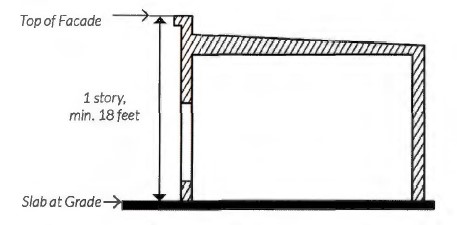
Note: Development in the MU-1 District is exempt from § 6.100. An unroofed and unenclosed roof top terrace, and the enclosed stairwell or elevator that strictly provides access to the terrace, shall not be included in the measurement of the total building height. Refer to §§ 5.136 and 5.137 Telecommunication Antenna and Towers.
a. For sloped sites, average grade is determined by calculating the average of the highest and lowest elevation along natural or the improved grade (whichever is more restrictive) along the front of the building parallel to the primary street setback line.

b. Where a lot of slopes downward from the front property line, one story that is additional to the specified maximum number of stories may be built on the lower rear portion of the lot.

(4) Maximum height general.
Building Floor | Maximum Height in Feet |
Ground floor | 20 feet |
Additional floors above ground floor | 15 feet per floor |
Apartment/condominiums top floor | 20 feet |
(5) Maximum height single- use. Three stories as measured from the top of the finished slab at grade level to the top of the highest wall top plate.

(6) Minimum residential units per acre. None, except when a residential mixed-use project is located within 1,320 feet of an entrance to an existing or approved passenger rail station or stop: 20.
(7) Maximum residential units per acre.
Maximum Building Height and Use | Maximum Units Per Acre |
3 stories, single use with surface parking | 40 units/acre |
3 stories, single use with structure parking | 50 units/acre |
4 stories, single use, with height bonus (structured parking or open space) | 60 units/acre |
4 stories, single use, with height bonuses (structured parking and open space) | 70 units/acre |
5 stories, single use, with height bonuses (structured parking and open space) | 70 units/acre |
5 stories, mixed-use | 80 units/acre |
(8) Height bonus options. Height bonuses can be utilized cumulatively but shall not allow for heights beyond the established five story maximum. When adjacent to a one-or-two family district, all height bonuses must adhere to the transitional height plane requirements, see subsection (f)(1)d.
a. Mixed-use building. A maximum of five stories provided that;
1. Residential uses account for no less than 20% of a building's gross floor area, and;
2. Office, eating and entertainment, and/or retail sales and service use account for no less than 10% of the building's gross floor area.
3. Live/work units may count toward the mixed-use requirement however, only the commercial square footage and its required restroom space of the unit shall count toward the calculation. All live/work units require a commercial certificate of occupancy (CO).
(i) Not exceed 3,000 square feet.
(ii) Maintain between 10% and 50% commercial space.
(iii) Not exceed five onsite employees who do not live in the unit.
(iv) Maintain adjacency between commercial and exterior entry.

b. Structured parking. The intent of allowing a height bonus of structured parking is to locate and design surface parking lots, individual garages, and large parking garages so as to reduce their visual impact or to create public amenities or both (e.g., through aesthetic or environmental features).
1. One additional story of height shall be permitted if providing structured parking for the project. Structured parking is intended to provide 100% of all off-street parking for the height bonus.
2. One-and-two family residential garages shall not be included in a determination of the applicability of the structured parking height bonus.
c. Open space. One additional story of height shall be permitted if providing a publicly accessible pocket park that adhere to the following standards.
Note: Utilizing the open space height bonus does not exempt a development from applicable park dedication fees.
1. Use criteria.
(i) Pocket parks must provide a community benefit such as: play activity for children, relaxing spaces to enjoy lunch or meet friends, interactive artwork, pet-friendly areas, or small event and garden space.
2. Location.
(i) Pocket parks must front public streets and be publicly accessible.
Note: Refer to subsection (h)(5), Development Standards Applicable to Privately Owned Streets and Drives with Public Access Easements.

3. Size.
(i) Two thousand five hundred (2,500) square feet minimum.
(ii) One (1) acre maximum.
4. Green space.
(i) Pocket parks shall provide a minimum of 20% ground level green space. Additional ground area may be impervious provided the space is structured for recreation, including, but not limited to sculpture gardens, basketball courts, or tennis courts.
(ii) All pocket parks require tree planting. Tree planting requirement may be waived for areas that are designed for structured recreation.
5. Seating.
(i) A minimum of one linear foot of seating shall be required for every 300 square feet of gross open space.
6. Fencing.
(i) Fencing for pocket parks must conform to subsection (h)(2) and must remain open to the public during daylight hours.
7. Maintenance.
(i) Pocket parks that are privately owned and maintained must be publicly accessible or:
(ii) Must be dedicated in perpetuity as public open space through the recording of a public use easement and have an established long-term maintenance agreement with the Park and Recreation Department.


(9) Applicability. Where existing buildings are affected by a rezoning to a Mixed-Use district, certain MU-1 standards will apply to subsequent or redevelopment of the building, depending on the extent of the improvement. The following table describes changes in intensity based on the uses as defined by the Institute of Traffic Engineers (ITE) trip generation and changes that increase the structure footprint or usable area. Usable area includes a change of use of any outdoor area from what was not a usable, occupiable area prior to the change.
0% to 15% Increase | >15% but <30% Increase | >30% Increase | |
Sidewalk | Required if existing sidewalks are substandard as determined by TPW | Required if existing sidewalks are substandard as determined by TPW | Required if existing sidewalks are substandard as determined by TPW |
Enhanced Landscaping | Does Not Apply; Street Trees shall be installed if not existing | Applies; Street Trees shall be installed as part of the total points if not existing | Applies; Street Trees shall be installed as part of the total points if not existing |
Setbacks | Does Not Apply | Applies in new footprint | Applies in new footprint |
Fenestration | Does Not Apply | Applies in new footprint or any areas of the existing building being modified | Applies in new footprint or any areas of the existing building being modified |
Entrances | Does Not Apply | Applies in new footprint | Applies in new footprint |
Urban Forestry | Does Not Apply unless new or expanded parking lots are provided | Applies in new footprint including any new or expanded parking lots | Applies in new footprint including any new or expanded parking lots |
(e) Off-street parking and loading.
(1) Commercial and mixed-use parking.
Location
| Requirement as a Percentage of Parking Requirement Listed in Section 6.201(B)
| |
Minimum
| Maximum**
| |
Project not located within 250 feet of a one- or two-family zoned property | None* | 100% |
Project located within 250 feet of a one- or two- family zoned property | 75% | 100% |
Project located within 1,320 feet of an existing or approved passenger rail station or stop | 50% | 100% |
*Residential uses as part of a mixed-use building shall provide required parking as listed in the residential parking table | ||
**For mixed-use buildings and projects, the maximum parking requirement shall be the sum of the individual requirements for all uses. | ||
(2) Residential parking.
Building Type/Use | Requirement | Proximity to Rail Station If the Development is Within 1,320 feet of a Rail Transit Station: |
Townhouse | 2 spaces per dwelling unit. See subsection (e)(5) for location requirements. | 1 space per dwelling unit. See subsection (e)(5) for location requirements. |
Duplex and Manor House (2+ units) | 2 spaces per dwelling unit; Plus, 1 space per bedroom over three bedrooms per dwelling unit. See subsection (e)(4) for location requirements for duplexes. | 1 space per dwelling unit; Plus, 1 space per bedroom over three bedrooms per dwelling unit. See subsection (e)(4) for location requirements for duplexes. |
Apartment/ Condominium | *0.75 to 1 space required per bedroom; Plus, 2 spaces per 500 square feet of leasing office and/or social rooms | *0.5 to 1 space required per bedroom; Plus, 2 spaces per 500 square feet of leasing office and/or social rooms. |
*All partial spaces are rounded up. | ||
(3) Other off-street parking and loading standards.
Note: These requirements supersede the parking requirements of § 6.201(b). All other requirements of Chapter 6, Article 2 apply.
a. Surface parking shall not be permitted between a building front and the street, provided however, angled, perpendicular or parallel parking that is designed to function as on-street parking shall be permitted if it meets the following three conditions:
1. The city's Traffic Engineer determines that the parking does not adversely affect public safety or circulation and satisfies the conditions described in § 22-175d of the City Code.
2. Each parking space is located adjacent to and is directly accessible from a public street or publicly accessible private street, and
3. Surface parking permitted between a building front and the street (on-street parking) and the required pedestrian walkway shall be either dedicated as public right-of-way or be included in a public access easement recorded in the real property records of the county. The front yard setback shall be measured from the curb instead of the property line, and the setback shall be no greater than 20 feet.
b. The required off-street parking for any use may be located off-site, on property within 500 feet of the subject site.
c. Adjacent on-street parking may be applied toward the minimum parking requirements only when it is located completely out of the travel lanes, provided; however, this shall not reduce the pertinent maximum parking limitations.
d. Joint use parking facilities may be used to meet minimum parking requirements in accordance with the following:
1. The total number of spaces shall not exceed the sum of the maximum spaces allowed for all individual uses sharing the facility.


2. There must be two or more uses on the same site, or on separate sites that are able to share the same parking spaces because their parking demands occur at different times.
3. The following documentation must be submitted in writing as part of the building permit application or site plan review:
(i) The names and addresses of the uses and of the owners or tenants that are sharing the parking;
(ii) The location and number of parking spaces that are being shared;
(iii) An analysis showing that the peak parking demands for the different uses occur at different times, and that the parking area will supply at least the minimum number of required spaces for each use during its respective peak parking times; and,
(iv) A legal instrument such as an easement or deed restriction that guarantees access to the joint parking for all uses.
e. Uses located in historically significant buildings shall be exempt from off-street parking requirements pursuant to § 6.201(b)(3). For the purpose of this exemption, historically significant buildings shall include those determined by the Historic Preservation Officer to be eligible, based on the applicable criteria, for:
1. Listing in the National Register of Historic Places; or
2. Local designation as either Historic and Cultural Landmark ("HC") or Highly Significant Endangered ("HSE").
f. Maximum surface parking lot frontage.
Intent: The intent of enforcing a maximum surface parking lot frontage is to establish a prominent and continuous street wall that promotes a multimodal, pedestrian-friendly environment while reducing the visual dominance and negative pedestrian impacts of large, street-facing surface parking lots.
1. The percentage of parking lot frontage along any street shall not exceed the following maximums:
(i) Forty percent (40%) of the development site's total frontage length along a project's primary streets; and

(ii) Seventy percent (70%) of the development site's total frontage length along a project's side streets.
2. Parking lot frontage measurements shall include the combined frontage length of any paved and/or drivable surface that functions as part of a parking lot's circulation, such as, but not limited to, drive aisles and parking spaces.
(4) Parking location for two-family dwellings.
a. All parking shall be located behind the front building line.
b. Garage doors that face the street must be located a minimum of 20 feet behind any front wall plane of a structure facing a publicly accessible ROW.
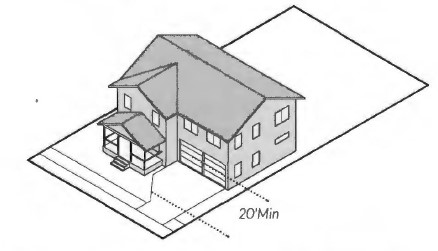
(5) Parking location for one-family attached (townhouse, rowhouse).
a. Garages must be placed entirely to the rear of the primary structure and accessed through the use of a rear driveway or alley.
b. Garage doors must face the rear driveway or alley.

(f) Buffers, landscaping, and pedestrian lighting.
(1) Bufferyard and supplemental building setback.
a. For the purpose of this section, the MU-1 District shall be considered a nonresidential district.
b. When building a two-unit attached dwelling (duplex) within the MU-1 District, a bufferyard and supplemental setback is not required when adjacent to a one-or-two family district.

c. All uses within the MU-1 district adjacent to a one- or two-family district, other than the uses listed in item b. above, must conform to the supplemental building setback and bufferyard width standards required for the Neighborhood Commercial ("E") District, as described in § 6.300(c) Area Requirements. See § 6.300(d) through (i) for bufferyard requirements.
d. All uses within the MU-1 district adjacent to a one-or two-family district must use a transitional height plane of 45 degrees to portions of a building above three stories or 45 feet, whichever is less starting from the property line of the one-or-two-family district.
1. Any portion of a building three stories must be set back so that the building does not encroach beyond the transitional height plane.
2. These supplemental building setbacks and transitional height plane requirements shall not apply to buildings adjacent to one-or-two-family districts that serve as public open space, such as parks and drainage ways.

(2) Enhanced landscaping and pedestrian lighting. Street trees and pedestrian-scaled lighting are required along all public rights-of-way in the MU-1 district, see subsection (h)(5). Adherence to the landscape ordinance, § 6.301 is encouraged, except as here-in provided.
a. The Director, or their designee, may administratively approve any modifications to streetscape requirements caused by mature trees, utility conflicts, fire hydrants, shallow underground utilities, curb cuts or any other obvious impediment, which could prevent the planting of a tree.
b. Street trees.
1. Trees must be planted within a planting strip or flush with the sidewalk surface using tree grates as follows:
(i) Tree grates must be adjustable to allow for tree growth and securely attached. Inner rings must be easily removed with an Allen wrench.
(ii) Tree grate openings shall not exceed 3/8 of an inch.
2. Exceptions.
(i) In the event that infrastructure prevents the use of at-grade planting, a raised planter or crushed stone may be used if approved by the Director or designee.
(ii) Other techniques to provide the street trees will be considered on a case-by-case basis and may be approved by the Director or their designee, or the Director or designee may send the matter to the Urban Design Commission for consideration and decision.
3. Spacing.
CANOPY SIZE | SPACING (ON CENTER) |
Small/Medium Canopy | 25-30 ft. |
Large Canopy | 35-40 ft. |
4. If there are no street trees existing on the project's block face, then spacing is measured from the end of the block beginning 40 feet from the curb intersection to accommodate public open space easement requirements.
c. Pedestrian-scaled lighting.
1. New public and private development must provide pedestrian lights within the roadside's street tree/furniture zone.


2. Required spacing. Pedestrian lights must be located approximately at the midpoint between two trees and spaced a maximum of 60 feet apart.
3. Pedestrian-scaled lighting style must be approved by the Transportation and Public Works Department (TPW) and be consistent with other pedestrian lights on the same block.
4. If there are no pedestrian lights existing on the project's block face, then the spacing is measured from the end of the block. If pedestrian-scaled lights exist, then spacing is measured from existing lights.
d. Section 6.301(h) "Landscape Area Required" does not apply to developments in the MU-l district provided however, the following are applicable in MU-1:
1. All landscaped areas must be located outside the perimeter of the footprint of a building or structure;
2. Protected by wheel stops, curbs or other physical barriers where adjacent to vehicle use areas;
3. Be covered with grass, organic mulch, live ground cover, decorative paving, sidewalk furniture or other decorative elements;
4. Landscaped bioretention areas are encouraged for natural drainage channels to reduce runoff and increase infiltration;
5. When there is a front yard setback of at least five feet, front yard landscaping is required for areas outside the ground level patios, parkways, and pedestrian walkways. Front yard landscaping must adhere to the shrub and native plans as listed in Table A of § 6.301(h), as well as other applicable regulations described or referenced within the MU-1 regulations.
e. Irrigation. An irrigation system must be installed to provide total water coverage to all plant materials installed pursuant to § 6.301
(i) Irrigation.
(3) Landscaping in parking and driveway areas.
Intent: The MU-1 district is intended to create a public environment in which pedestrian safety, interest, and comfort are paramount. Therefore, parking areas that front public streets and pedestrian pathways shall be screened to minimize pedestrians' view of parked vehicles and the impact of vehicle headlights.
a. Parking lots and driveways that are located adjacent and parallel to a public street must be screened from the public right-of-way with landscaping, berms, fences, or walls a minimum of 3 feet in height measured from parking lot grade to a maximum of four feet in height.
b. Landscape islands, linear landscaping strips, bio-swales, or rain gardens must be required in parking lots with 12 or more spaces. All landscape islands and strips shall have at least one tree.

c. Every parking space is required to be not more than 60 feet from a large canopy tree or 40 feet from a medium canopy tree, planted within a median, strip or island, measured from the trunk at planting.


d. Required size of landscape islands and linear landscaping strips containing trees:
1. Within parking lots with non-porous surfaces: 130 square feet; eight feet minimum width.
2. Planted in structured soil: 64 square feet; eight feet minimum width. The use of approved structural soil shall be limited to landscape islands and adjacent walkways and parking area necessary for proper tree growth. Structural soils must not be used for fire lanes in parking lots.
3. Within parking lots with approved porous surfaces for parking areas excluding fire lanes: 16 square feet. Tree trunks should be protected by wheel stops or other physical barriers excluding curbs.
e. Linear landscaping strips are encouraged in lieu of landscaping islands where possible.
(4) Urban forestry.
a. Developments with surface parking lots must provide 40% canopy coverage over new, expanded, or reconstructed surface parking.
b. Submission of applicable urban forestry plans for review shall comply with § 6.302 (g), Urban Forestry Plan/Permits.
(g) Facade design standards.
(1) Parking structure facades.
a. Facade design. All parking structure facades that face a public space must be designed to incorporate architectural elements and materials that complement the adjacent building or buildings in the area.
b. Ground level screening. Screening must be incorporated to minimize the visual impact of garages and parked cars at the pedestrian level. Landscaping, including trees and shrubs, may be utilized for screening purposes but must screen at least 50% of pedestrian level parking garage facades immediately upon installation, with species selected to eventually provide a full 100% screening.


c. Parking structure openings. Parking structure vehicle access facing public and private streets, excluding alleys, shall not exceed 25 feet along the same frontage.
1. For multifamily buildings less than 150 feet in width, the parking structure opening, the parking structure, or both combined, shall not exceed 50% of the ground floor street facade, with the remaining facade for occupiable space.
2. For multifamily buildings 150 feet or more in width, the parking structure opening, the parking structure, or both combined, shall not exceed 25% of ground floor street facade, with the remaining facade for occupiable space.
d. The property owner is responsible for maintaining all required landscaping in good health and condition and the removal of any litter that has accumulated in landscaped areas. Any dead, unhealthy, damaged or missing landscaping and screening must be replaced with landscaping and screening that conforms to this subsection within 90 days (or within 180 days where weather concerns would jeopardize the health of plant materials).
(2) Facade variation.
a. Each new building facade that is greater than 50 feet in width and is oriented to a publicly accessible street or open space must incorporate each of the following scaling elements. For building facades less than 50 feet in width, a minimum of two elements are required.
1. Expression of building structural elements such as:
(i) Floors (banding, belt courses, etc. not less than one inch deep and four inches wide).
(ii) Columns (pilasters, piers, quoins, etc. not less than one inch deep and six inches wide).
(iii) Foundation (water tables, rustication).
2. At least two variation in wall plane not less than three feet in depth or projection and not less than two stories in height for multi-story buildings. Such elements could include patterns of door and window openings by utilizing sills, mullions, and other scale providing window elements, and/or more pronounced architectural features such as porches, alcoves, and roof dormers;

3. Changes in material, material pattern, or noticeable change in color or shade. Each change of material shall involve a minimum one-inch variation in wall plane or noticeable change in color.


b. New building facades oriented to a publicly accessible street or open space must include differentiation between the first and the upper levels with a canopy, balcony, arcade, or other architectural features.
c. If a project consists of more than one block face, each sequential block of new construction must contain a different building facade to encourage architectural variety within large projects, using the required architectural elements listed in subsection (g)(3)a above and/or other architectural features.
(3) Fenestration.
Intent: Providing fenestration encourages interaction between the pedestrian and the ground-story space. The intent of requiring clear fenestration is to allow pedestrians to view activities inside the building or displays related to those activities.
a. New single use commercial and mixed-use building facades fronting publicly accessible street or open space shall meet the following requirements:
Project Type | Fenestration Requirement |
Primary and Secondary Street |
Project Type | Fenestration Requirement |
Primary and Secondary Street | |
Mixed-Use and Commercial | |
Ground Story (2'-12' above grade) | 40% |
Upper Stories | 25% |
Residential | |
Ground Story (2'-12' above grade) | None |
Upper Stories | None |
b. Clear glazing shall have a visible transmittance rating of 0.5 or greater to count towards the fenestration requirement.
c. The following alternatives may count towards a portion of the fenestration requirement and can be used in singular or in combination. Alternatives may count no more than 50% of the total fenestration requirement.
Alternative | Percentage of Alternative Counting Towards Total Requirement |
Windows at the ground story but outside the 2-12' zone | 40% |
Wall mounted or recessed display cases at least 4' high | 40% |
Walk-up automated teller machines, video rental or similar kiosk | 40% |
Translucent, fritted, patterned, or color glazing | 40% |
Energy efficient windows that do not meet the .5 transmittance requirement | 40% |
Outdoor dining/seating located between the building and street | 60% |

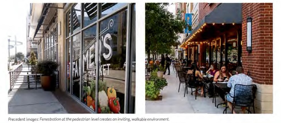
(4) Building materials. Not less than 70% of all new building facades (not including door and window areas) facing publicly accessible streets or open space shall be constructed of the following masonry materials:
a. Stone.
b. Brick.
c. Terra cotta.
d. Patterned pre-cast concrete.
e . Cement piaster stucco.
f. Cement board siding.
g. Cast stone or prefabricated brick panels.

(5) Building entries.
Intent: The intent of building entries is to create a pedestrian-oriented development in which buildings are oriented toward publicly accessible streets and sidewalks.
a. The principle building must have its main entrance from a public sidewalk or plaza, or from a private sidewalk or plaza that is publicly accessible through a public use easement. Interior buildings constructed as part of a campus development are exempt from these requirements (see subsection (d)(4)c, Campus Development).
b. Primary entrances shall not be from a parking lot.
c. Secondary entrances from parking lots are permitted.
d. All public building entrances for commercial developments and primary entrances for residential units must incorporate arcades, roofs, porches, alcoves, or awnings that protect pedestrians from the sun and rain.


e. Residential entries.
1. Apartments, condominiums, and manor houses with street level units must provide individual street-oriented entries for each unit along the primary street frontage.

2. Apartments and condominiums must provide primary entrances at intervals not to exceed 125 linear feet of street- oriented building frontage. Entrance spacing is measured from the edge of door to the edge of the next door.
3. Townhouses must have individual street- oriented entries for each unit.
4. Manor houses must have a single primary entrance.

5. A duplex may have one primary entrance for each unit. Each primary entrance into a duplex must be provided under a shared porch or one of the entrances must be accessed from a side facade of the structure.
f. Commercial entries.
1. Each retail use with exterior ground level exposure along a street or public space shall have an individual public entry from the street or public space.
2. Entrances to corner buildings with ground floor retail uses shall be located at the corner of the primary street.
(h) Other development standards.
(1) Signs. In addition to the development standards in Chapter 6, Article 4, the following provisions apply:
a. In addition to signs allowed in Chapter 6, Article 4, one or more attached project identifier or wayfinding signs may be erected on each facade of the occupied space.
Note: Doors and windows shall be included in the calculation of the facade area.
1. Signs may have a total area of 10% of the area of the facade to which the signs are attached, with a maximum aggregate area of 500 square feet per facade.
2. The facade area shall be calculated by multiplying the width times the height, with a maximum calculated height of 15 feet.
3. For structures exceeding 15 feet in height, allowable sign square footage shall be calculated as 0.75 square feet per linear foot of building facade.
(2) Fences, gates, and walls.
a. Complexes with perimeter security fencing along public streets are prohibited.
b. Fences shall not be located in the area between the front building facade and the public street frontage or public open space.
c. Exterior fences and gates that are located along public streets, along private streets or walkways that are publicly accessible through a public use easement, or along publicly accessible open space shall not extend beyond building facades.
d. All fences and walls along public street frontage or public open space that are taller than four feet must be open design.
e. All fences and railings must be architecturally compatible with the character of the building and be constructed of high-quality materials including: wrought iron, composite fencing, treated wood, aluminum, or metal. Chain link, barbed wire, and concertina wire material is prohibited.

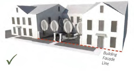
f. All walls must be architecturally compatible with the character of the building and constructed of high-quality materials including stone, decorative blocks, brick, cast stone, or stucco over standard concrete masonry blocks.
g. For a private residential patio or yard, or a commercial outdoor dining area, a fence, railing, or low wall may extend beyond the building facade if the following requirements are met:
1. Fences, railings, and walls must not exceed four feet (48") in total height as measured from the ground to the top of the fence, railing and/or the wall however;
2. For elevated residential stoops the total fence, railing and/or wall height must not exceed five feet (60") total.

(3) Service areas screening.
a. Trash and recycling collection, and other similar service areas, must be located to the side or rear of buildings and behind the primary structures on street frontages.
b. All refuse and recycling collection containers for apartments/condominiums must be located on a concrete pad and shall be screened on 3 sides by an opaque fence or wall. The fourth side must be an opaque gate.
c. The design, colors, and materials of screening elements shall be architecturally compatible with the character of the building.


(4) Mechanical equipment screening.
Alternative | Fully Screened from Public Right-of-Way (Alleys excluded) | Permitted Screening Materials | ||
Landscaping | Opaque Wall/Fence | Architectural Screening Elements | ||
Wall-Mounted | • | • | •2 | |
Roof-Mounted | •1 | • | ||
Ground-Mounted | • | • | •2 | |
1 Must be screened from abutting properties and the public street. 2 If an opaque wall or fence is provided, it shall be compatible with the principle building in terms of texture, quality, material, and color. | ||||


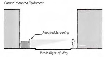
(5) Privately owned streets and drives with public access easements. Private streets and drives with public access easements shall be considered public streets or right-of-way for the purpose of review for compliance with setbacks, pocket parks, parking, screening, enhanced landscaping, facade variations, fenestration, and other MU-1 design requirements normally based on streets.
(6) Drive-in business.
a. Drive-in businesses may be permitted in accordance with the use tables in Chapter 4, Articles 6 and 8, provided that no such use shall be permitted to sell alcoholic beverages for consumption on the premises. In the MU-1 district the following requirements shall apply:
1. Drive-through windows and stacking lanes shall not be located along facades of buildings that face a street, and where possible shall be located to the rear of buildings;
2. Driveways shall not be located within the front yard setback between the building front and the street;
3. The design and location of the facility shall not impede vehicular traffic flow and shall not impede pedestrian movement and safety. To minimize conflicts with vehicular and pedestrian circulation, shared driveways and/or driveways located off of non-arterial streets shall be used, where possible;
4. Architectural elements, landscaping and/ or other screening elements shall be provided to minimize the visual impacts of the drive-through facility; and
5. The design and location of the facility hall be consistent with any design standards or guidelines that may be applicable to the pertinent district.
(Ord. 20159-04-2012, § 1 (Exh. A), passed 4-3-2012; Ord. 21782-07-2015, § 1, passed 7-16-2015, eff. 7-26-2015; Ord. 22810-08-2017, § 1 (Exh. A), passed 8-1-2017, eff. 9-7-2017; Ord. 23648-05-2019, §§ 1-3, 5-11, passed 5-7-2019; Ord. 24030-02-2020, § 22, passed 2-4-2020; Ord. 25189-11-2021, § 1, passed 11-9-2021, eff. 12-16-2021; Ord. 26920-05-2024, § 1, passed 5-14-2024, eff. 7-16-2024)
Editor’s note:
Ord. 22810-08-2017, § 3, adopted August 1, 2017, repealed § 4.1301, derived from Ord. 20159-04-2012, § 1 (Exh. A), passed April 3, 2012, amended by Ord. 21782-07- 2015, § 2, passed July 16, 2015, which pertained to the Low Intensity Mixed-Use (“MU- 1G”) District. See also the Code Comparative Table.
(a) Purpose and intent. It is the purpose and intent of the High Intensity Mixed-Use (MU-2) District to provide areas in which a variety of higher density housing types exist among commercial, institutional, and selected light industrial uses. The MU-2 District is designed to accommodate and encourage compact, walkable development forms that are more land-efficient, cost-effective, and revenue positive for the City than low density, single-use developments. In addition to the purpose statements above, the intent of the MU-2 District is to:
(1) Promote a pedestrian-oriented urban form. In contrast to conventional zoning standards that place a primary emphasis on the regulation of land uses, mixed-use development standards and guidelines focus on promoting a walkable, urban form of development, consistent with the surrounding areas historic urban development patterns. The focus on form promotes buildings that conform to tested urban design principles.
(2) Require excellence in design of the public realm and of buildings that front public spaces. The most successful and memorable urban environments are those in which walking down the street is appealing. Streets, plazas, parks, and other public spaces should be comfortable and inviting, and buildings fronting those spaces should be active and visually interesting at the pedestrian level.
(3) Encourage creativity, architectural diversity, and exceptional design. Mixed-use is intended to promote high quality design, and the development review process for mixed-use projects is intended to promote flexibility. Standards, as well as the development review process, are intended to support creativity and exceptional design while discouraging uniformity.
(4) Promote sustainable development that minimizes negative impacts on natural resources. Creating walkable, higher density residential districts surrounding mixed-use districts supports sustainable development by providing an alternative to low density development in peripheral areas. In accordance with sustainable development principles, the mixed-use buildings and public spaces should be designed to minimize negative impacts on air and water quality and promote innovation in environmental design.
(5) Promote walkability. Walkable communities are desirable places to live, work, and play. Walkable communities give higher priority to pedestrian activity by creating streetscapes that are safe, comfortable, interesting, and that accommodate a wide range of transportation modes and users. To foster walkability, development patterns should promote a mix of land uses and density, have an emphasis on the placement and orientation of buildings, have properly placed parking, place a high value on the design of quality streetscapes, provide access to transit, and provide unimpeded pedestrian connections to multiple destinations and open space.
(6) Maximize connectivity and access. In order for people to feel comfortable walking, pedestrian access and connectivity among uses and amenities, including transit facilities, is essential. Connectivity and access can be accomplished by creating smaller blocks or by providing access through blocks via publicly accessible alleys, pathways, paseos, and pedestrian boulevards. Sidewalks should form a continuous network connected by frequent, safe street crossing.
(7) Promote affordable housing and mixed income communities. Design a mix of housing based on geographic growth projections and the needs of current and future residents to accommodate families, single occupants, the elderly and those with disabilities. Access to transportation and services should be a key factor in the future distribution and allocation of affordable housing.
(b) Review procedures for development.
(1) General requirements. Projects should conform to all mixed-use standards. Staff may also refer an administrative case or a case that does not require waivers to the UDC for failure to meet the Purpose and Intent of the ordinance.
(2) General rule allowing waiver or modification of standards.
a. Director or designee. The Director or designee is authorized to grant modifications to certain development standards with a maximum modification up to 10% increase or decrease for the following development standards:
1. Setbacks for additions to existing structures.
2. Bufferyard width.
3. Primary entrance separation.
4. Fenestration.
b. Urban Design Commission. Unless otherwise limited by this section, the Urban Design Commission (UDC), may waive or modify any individual development standards through the issuance of a Certificate of Appropriateness, if the UDC finds that the proposed development is consistent with the intent statements of the MU-2 District but does not conform to certain development standards. A Certificate of Appropriateness shall expire if a building permit is not received within two years of the approval of the Certificate of Appropriateness.
c. Board of Adjustment. Any waiver of basic property development related to building heights, setbacks and bulk require a variance to the Board of Adjustment after a recommendation provided by the Urban Design Commission prior to the public hearing of the Board of Adjustment.
d. Zoning Commission/City Council. Any zoning proposal requesting a Planned Development "PD" zoning district that uses the MU-2 district as the base zoning, inclusive of any waivers from any MU-2 design standards, must receive a recommendation from the Urban Design Commission prior to a public hearing by the Zoning Commission or the City Council.
(3) Conceptual land use plan. To facilitate compliance with the MU-2 District regulations, a conceptual land use plan must be submitted to the Director or designee for review and approval prior to submitting permit applications. The conceptual land use plan must include the following:
a. The anticipated location of proposed streets, sidewalks and walkways, building footprints, parking areas, landscaped areas and features, and open space. A change of 5% or greater in land uses to a conceptual land use plan will require a new project review and approval prior to permitting.
b. The conceptual site plan shall illustrate the proposed location of land uses on the site, using the following land use categories:
1. Residential (single-family, one-or-two-family attached, multi-family, etc.) Leasing offices in multifamily developments shall count towards residential use calculations.
2. Commercial/industrial.
3. Institutional/dedicated public parks (e.g. hospitals, schools, churches, government buildings, dedicated public parks and the likes).
4. Mixed-use buildings (a mix of residential and non-residential within the same building, meeting the percentage requirements defined in subsection (d)(7)a.
c. Parking facilities and private open spaces shall be classified the same as the primary land use they serve.

(4) Proximity test. Developments that are 90% or greater residential uses must perform a proximity test to ensure a mix of uses in the surrounding area. No development that comprises 90% or greater residential uses shall be permitted unless the Director, or designee determines one of the following:
a. The residential land use category within a 1,320-foot radius of the proposed project site boundary, shall not occupy greater than 70% of the total land area. The proposed development shall be included in the calculation of this percentage. The land use are percentages shall be based on current land uses and calculated using land use information obtained from the applicable tax appraisal district, site visits, or property research; or
b. There are demonstratable unique site conditions (e.g. adjacency to natural features, freight yards, etc.) make compliance with the conditions of section a above impractical in certain areas of the development site.

(c) Uses. In the MU-2 District, no building or land use shall be used and no building shall be hereafter erected, reconstructed, altered or enlarged, nor shall a Certificate of Occupancy be issued, except in accordance with the use table in Chapter 4, Article 12, and the supplemental standards of Chapter 5. Residential, commercial, and institutional uses may occupy the same building lot.
(1) Building types. The following non-exhaustive list of conceptual building illustrations demonstrate the recommended building forms in the MU-2 District. Additional building types and configurations that comply with the intent and regulations of the MU-2 district are encouraged. All intent statements are addressed through development standards set out in § 4.1302 (d) through (h).

a. General commercial. A development type with nonresidential uses. Ground story spaces are flexible enough to accommodate a variety of nonresidential uses. Upper stories are used for offices and/or other types of compatible nonresidential uses.

b. Mixed-use shopfront. A development type with ground-story retail and upper-story residential and/or office uses.

c. Apartment/condominium. Multi-family residential development type that often shares a common entrance. Primary entrances are prominent and street-facing. An elevated ground floor for residential uses is recommended to improve privacy. Parking for an apartment/condominium building is allowed on the side or rear of the building, but the preferred method is at the rear of the building or within a parking structure. A townhouse form shall be considered an apartment/condominium when the homes are on one platted lot and not on individually platted lots with ground floor separate entrances to each unit.

d. One-family attached (townhouse). A two- or three-story building with two or more attached dwelling units consolidated into a single structure and platted into individual lots. An elevated ground floor for residential uses is recommended to ensure privacy. A townhouse form is regarded as an apartment/condominium when on one platted lot and not individually platted lots with ground floor separate entrances to each unit.

e. Manor house. A building that has the appearance of a conventional single-family dwelling with three to five attached dwelling units consolidated in a single structure. Dwelling units within a building may be situated either wholly or partially over or under other dwelling units.

f. Two-family attached (duplex). A building with two dwelling units on an individual lot separated by a shared common wall. Dwelling units within a building may be situated either wholly or partially over or under other dwelling units.
(d) Property development standards.
(2) Setbacks. The chart below represents the minimum and maximum setbacks for building and structures within a MU-2 District.
Requirement | Distance |
1. Primary street (min./max.) | 0'/20' |
2. Side street (min./max.) | 0'/20' |
3. Rear yard (min.) | 5' |
4. *Common lot line (min.) | 0' |
*Subject to building code spacing requirements | |

a. Buildings on corner lots shall not exceed the maximum front yard setback on primary and side streets.
b. Buildings may exceed the maximum 20-foot setback if angled, perpendicular, or parallel parking on private property meets the conditions of subsection (e)(3)a. In these situations, the front yard setback shall be measured from the curb instead of the property line, and the setback shall be no greater than 20 feet.
c. Campus Developments: Interior buildings constructed as part of a campus development may be set back from the property line more than 20 feet if at least 50% of the public street frontage on each block face within the development contains buildings within the maximum setback of 20 feet. Interior buildings setback farther than 20 feet may not be constructed until the 50% requirement has been satisfied.
Note: A campus development is defined as a unified group of buildings and/or facilities located on a contiguous parcel and operated as a place of worship, school, or hospital.
(3) Minimum height single-use. Two stories at a minimum 18 feet of occupiable space as measured from the top of the finished slab at grade level to the top of the highest wall top plate.
Intent: The High Intensity MU-2 zoning ordinance requires a minimum of two stories in order to promote and accommodate higher densities of land uses within a building.

Note: Development in the MU-2 District is exempt from § 6.100. An unroofed and unenclosed roof top terrace, and the enclosed stairwell or elevator that strictly provides access to the terrace, shall not be included in the measurement of the total building height. Refer to §§ 5.136 and 5.137 Telecommunication Antenna and Towers.
a. For sloped sites, average grade is determined by calculating the average of the highest and lowest elevation along natural or the improved grade (whichever is more restrictive) along the front of the building parallel to the primary street setback line.
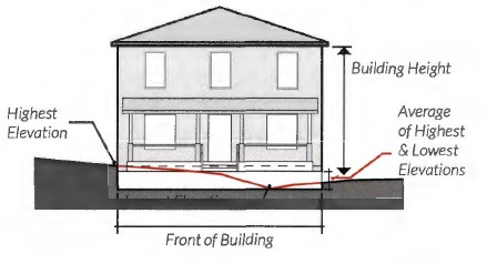
b. Where a lot slopes downward from the front property line, one story that is additional to the specified maximum number of stories may be built on the lower rear portion of the lot.

(4) Maximum height general.
Building Floor | Maximum Height in Feet |
Ground floor | 20 feet |
Additional floors above ground floor | 15 feet per floor |
Apartment/condominiums top floor | 20 feet |
(5) Maximum height single-use.
a. Generally. Five stories as measured from the top of the finished slab at grade level to the top of the highest wall top plate.
b. Single-use office building. A maximum height of ten stories shall be allowed, provided a maximum height of five stories shall be required within 250 feet of A or B residential districts with an existing one- or two-family dwelling. Retail and restaurant uses on the ground floor are allowed and encouraged. Buildings within 1,000 feet of property on the block bounded by University Drive, Lancaster Avenue, Montgomery Street, and Camp Bowie Boulevard, shall have a maximum height of 120 feet.
c. Single-use hotel building. A maximum height of ten stories shall be allowed, provided a maximum height of five stories shall be required within 250 feet of A or B residential districts with an existing one- or two-family dwelling. Retail and restaurant uses on the ground floor are allowed and encouraged. Buildings within 1,000 feet of property on the block bounded by University Drive, Lancaster Avenue, Montgomery Street, and Camp Bowie Boulevard, shall have a maximum height of 120 feet.

(6) Minimum residential units per acre. None, except when a residential mixed-use project is located within 1,320 feet of an entrance to an existing or approved passenger rail station or stop: 50.
(7) Maximum residential units per acre.
Maximum Building Height And Use | Maximum Units Per Acre |
Up to 4 stories, single use | 70 units/acre |
5 stories, single use | Unlimited |
6 stories, single use, with height bonus (structured parking or open space) | Unlimited |
7-9 stories, single use, with height bonuses (structured parking and open space) | Unlimited |
10 stories, mixed-use | Unlimited |
(8) Height bonus options. Height bonuses can be utilized cumulatively but shall not allow for heights beyond the established ten story maximum. When adjacent to a one- or two-family district, all height bonuses must adhere to the transitional height plan requirements, see subsection (f)(l)d.
a. Mixed-use building. A maximum height of ten stories shall be allowed provided the criteria below are met. Buildings within 1,000 feet of property on the block bounded by University Drive, Lancaster Avenue, Montgomery Street, and Camp Bowie Boulevard, shall have a maximum height of 120 feet.
1. Residential uses account for no less than 20% of a building's gross floor area, and;
2. Office, eating and entertainment, and/ or retail sales and service uses or all account for no less than 10% of the building's gross floor area.
3. Live/work units may be counted toward the mixed-use requirement, provided however, only the commercial square footage and its required restroom space of the unit shall be used when determining the calculation. All live/work units require a commercial certificate of occupancy and shall:
(i) Not exceed 3,000 square feet.
(ii) Maintain between 10% and 50% commercial space.
(iii) Not exceed five onsite employees who do not live in the unit.
(iv) Maintain Adjacency between commercial and exterior entry.

b. Structured parking. The intent of allowing a height bonus for structure parking is to locate and design surface parking lots, individual garages, and large parking garages so as to reduce their visual impact or to create public amenities or both (e.g. through aesthetic or environmental features).
1. One additional story of height shall be permitted if providing structured parking for 100% of all off-street parking for the height bonus.
2. One-and-two family residential garages shall not be included in a determination of the structured parking height bonus.
c. Open space. One additional story of height shall be permitted if providing a publicly accessible urban pocket park that adheres to the following standards.
Note: Utilizing the open space height bonus does not exempt a development from applicable park dedication fees.
1. Use criteria.
(i) Pocket parks must provide a community benefit such as: play activity for children, relaxing spaces to enjoy lunch or meet friends, interactive artwork, pet-friendly areas, or small event and garden space.
2. Location.
(i) Pocket parks must front public streets and be publicly accessible.
Note: Refer to subsection (h)(5), Development Standards Applicable to Privately Owned Streets and Drives with Public Access Easements.

3. Size.
(i) Two thousand five hundred (2,500) square feet minimum.
(ii) One (1) acre maximum.
4. Green space.
(i) Pocket parks shall provide a minimum of 20% ground level green space. Additional ground area may be impervious provided the space is structured for recreation, including, but not limited to, sculpture gardens, basketball courts, or tennis courts.
(ii) All pocket parks require tree planting. Tree planting requirement may be waived for areas that are designed for structured active recreation.
5. Seating.
(i) A minimum of one linear foot of seating shall be required for every 300 square feet of gross open space.
6. Fencing.
(i) Fencing for pocket parks must conform to Subsection (h)(2) and must remain open to the public during daylight hours.
7. Maintenance.
(i) Pocket parks that are privately owned and maintained must be publicly accessible or;
(ii) Must be dedicated in perpetuity as public open space through the recording of a public use easement and have an established long-term maintenance agreement with the Park and Recreation Department.


(8) Applicability. Where existing buildings are affected by a rezoning to a Mixed-Use district, certain MU-2 standards will apply to subsequent reuse or redevelopment of the building, depending on the extent of the improvement. The following table describes changes in intensity based on uses as defined by the Institute of Traffic Engineers (ITE) trip generation manual and changes that increase the structure footprint or usable area. Usable area includes a change of use of any outdoor area from what was not a usable, occupiable area prior to the change.
0% to 15% Increase | >15%, but <30% Increase | >30% Increase |
0% to 15% Increase | >15%, but <30% Increase | >30% Increase | |
Sidewalk | Required if existing sidewalks are substandard as determined by TPW | Required if existing sidewalks are substandard as determined by TPW | Required if existing sidewalks are substandard as determined by TPW |
Enhance Landscapin g | Does Not Apply; Street Trees shall be installed if not existing | Applies; Street Trees shall be installed as part of the total points if not existing | Applies; Street Trees shall be installed as part of the total points if not existing |
Setbacks | Does Not Apply | Applies in new footprint | Applies in new footprint |
Fenestration | Does Not Apply | Applies in new footprint or any areas of the existing building being modified | Applies in new footprint or any areas of the existing building being modified |
Entrances | Does Not Apply | Applies in new footprint | Applies in new footprint |
Urban Forestry | Does Not Apply unless new or expanded parking lots are provided | Applies in new footprint including any new or expanded parking lots | Applies in new footprint including any new or expanded parking lots |
2nd Story | Does Not Apply | Does Not Apply | Applies to existing 2+ story building. If a building addition is 60% or more, the addition shall comply with the 2-story minimum. An addition of less than 60% expansion may expand at the same level as the existing structure. |
(e) Off-street parking and loading.
(1) Commercial and mixed-use parking.
Location | Requirement as a Percentage of Parking Requirement Listed in Section 6.201(B) | |
Minimum | Maximum** | |
Project not located within 250 feet of a one- or two- family zoned property | None* | 100% |
Project located within 250 feet of a one- or two- family zoned property | 75% | 100% |
Project located within 1,320 feet of an existing or approved passenger rail station or stop | 50% | 100% |
*Residential uses as part of a mixed-use building shall provide required parking as listed in the residential parking table. **For mixed-use buildings and projects, the maximum parking requirement shall be the sum of the individual requirements for all uses. | ||
(2) Residential parking.
Building Type/Use | Requirement | Proximity to Rail Station If the Development is Within 1,320 feet of a Rail Transit Station: |
Townhouse | 2 spaces per dwelling unit. See subsection (e)(5) for location requirements. | 1 space per dwelling unit. See subsection (e)(5) for location requirements. |
Duplex and Manor House (2+ units) | 2 spaces per dwelling unit; Plus, 1 space per bedroom over three bedrooms per dwelling unit. See subsection (e)(4) for location requirements for duplexes. | 1 space per dwelling unit; Plus, 1 space per bedroom over three bedrooms per dwelling unit. See subsection (e)(4) for location requirements for duplexes. |
Apartment/ Condominium | *0.75 to 1 space required per bedroom; Plus, 2 spaces per 500 square feet of leasing office and/or social rooms. | *0.5 to 1 space required per bedroom; Plus, 2 spaces per 500 square feet of leasing office and/or social rooms. |
*All partial spaces are rounded up. | ||
(3) Other off-street parking and loading standards.
Note: These requirements supersede the parking requirements of § 6.201(b). All other requirements of Chapter 6, Article 2 apply.
a. Surface parking shall not be permitted between a building front and the street, provided however, angled, perpendicular, or parallel parking that is designed to function as on- street parking shall be permitted if meets the following three conditions:
1. The City's Traffic Engineer determines that the parking does not adversely affect public safety or circulation and satisfies the conditions described in § 22-175d of the City Code.
2. Each parking space is located adjacent to and is directly accessible from a public street or publicly accessible private street; and
3. Surface parking permitted between a building front and the street (on-street parking) and the required pedestrian walkway shall be either dedicated as public right-of-way or be included in a public access easement recorded in the real property records of the county. The front yard setback shall be measured from the curb instead of the property line, and the setback shall be no greater than 20 feet.
b. The required off-street parking for any use may be located off-site, on property within 500 feet of the subject site.
c. Adjacent on-street parking may be applied toward the minimum parking requirements only when it is located completely out of the travel lanes, provided however, this shall not reduce the pertinent maximum parking limitations.
d. Joint use parking facilities may be used to meet minimum parking requirements in accordance with the following:
1. The total number of spaces shall not exceed the sum of the maximum spaces allowed for all individual uses sharing the facility.


2. There must be two or more uses on the same site, or on separate sites are able to share the same parking spaces because their parking demands occur at different times.
3. The following documentation must be submitted in writing as part of the building permit application or site plan review:
(i) The names and addresses of the uses and of the owners or tenants that are sharing the parking;
(ii) The location and number of parking spaces that are being shared;
(iii) An analysis showing that the peak parking demands for the different uses occur at different times, and that the parking area will supply at least the minimum number of required spaces for each use during its respective peak parking times; and,
(iv) A legal instrument such as an easement or deed restriction that guarantees access to the joint parking for all uses.
e. Uses located in historically significant buildings shall be exempt from off-street parking requirements pursuant to § 6.201(b)(3). For the purpose of this exemption, historically significant buildings shall include those determined by the Historic Preservation Officer to be eligible, based on the applicable criteria, for:
1. Listing in the National Register of Historic Places; or
2. Local designation as either Historic and Cultural Landmark ("HC") or Highly Significant Endangered ("HSE").
f. Maximum surface parking lot frontage.
Intent: The intent of enforcing a maximum surface parking lot frontage is to establish a prominent and continuous street wall that promotes a multimodal, pedestrian-friendly environment while reducing the visual dominance and negative pedestrian impacts of large, street-facing surface parking lots.
1. The percentage of parking lot frontage along any street shall not exceed the following maximums:
(i) Forty percent (40%) of the development site's total frontage length along a project's primary streets, and

(ii) Seventy percent (70%) of the development site's total frontage length along a project's side streets.
2. Parking lot frontage measurements shall include the combined frontage length of any paved and/ or drivable surface that functions as part of a parking lot's circulation, such as, but not limited to, drive aisles and parking spaces.
(4) Parking location for two-family dwellings.
a. All parking shall be located behind the front building line.
b. Garage doors that face the street must be located a minimum of 20 feet behind any front wall plane of a structure facing a publicly accessible ROW.

(5) Parking location for one-family attached (townhouse, rowhouse).
a. Garages must be placed entirely to the rear of the primary structure and accessed through the use of a rear driveway or alley.
b. Garage doors must face the rear driveway or alley.

(f) Buffers, landscaping, and pedestrian Lighting.
(1) Bufferyard and supplemental building setback.
a. For the purpose of this section, the MU-2 District shall be considered a nonresidential district.
b. When building a two-unit attached dwelling (duplex) within the MU-2 District, a bufferyard and supplemental setback is not required with an adjacent one-or-two family district.

c. All uses within the MU-2 district adjacent to one- or two-family district, other than the uses listed in item b. above, shall conform to the supplemental building setback and bufferyard width standards required for the Neighborhood Commercial ("E") District, as described in Section 6.300(c) Area Requirements. See § 6.300(d) through (i) for bufferyard requirements.
d. All uses within the MU-2 district adjacent to a one-or two-family district must use a transitional height plane of 45 degrees to portions of a building above three stories or 45 feet, whichever is less starting from the property line of the one-or-two-family district.
1. Any portion of a building three stories shall be set back so that the building does not encroach the transitional height plane.
2. These supplemental building setbacks and transitional height plane requirements shall not apply to buildings adjacent to one-or-two-family districts that serve as public open space, such as parks and drainage ways.

(2) Enhanced landscaping and pedestrian lighting. Street trees and pedestrian-scaled lighting are required along all public rights-of-way in MU-2, see subsection (h)(5). Adherence to the landscape ordinance, § 6.301 is encouraged, except as here-in provided.
a. The Director, or their designee, may administratively approve any modifications to streetscape requirements caused by mature trees, utility conflicts, fire hydrants, shallow underground utilities, curb cuts or any other obvious impediment, which could prevent the planting of a tree, which could prevent the planting of a tree.
b. Street trees.
1. Trees must be planted within a planting strip or flush with the sidewalk surface using tree grates as follows:
(i) Tree grates must be adjustable to allow for tree growth and securely attached. Inner rings must be easily removed with an Allen wrench.
(ii) Tree grate openings shall not exceed 3/8 of an inch.
2. Exceptions.
(i) In the event that infrastructure prevents the use of at-grade planting, a raised planter or crushed stone may be used if approved by the Director or designee.
(ii) Other techniques to provide the street trees will be considered on a case-by-case basis and may be approved by the Director or their designee, or the Director or designee may send the matter to the Urban Design Commission for consideration and decision.
3. Spacing.
Canopy Size | Spacing (On Center) |
Small/Medium Canopy | 25-30 ft. |
Large Canopy | 35-40 ft. |
4. If there are no street trees existing on the project's block face, then spacing is measured from the end of the block beginning 40 feet from the curb intersection to accommodate public open space easement requirements.
c. Pedestrian-scaled lighting.
1. New public and private development must provide pedestrian lights within the roadside's street tree/furniture zone.


2. Required spacing. Pedestrian lights must be located approximately at the midpoint between two trees and spaced a maximum of 60 feet apart.
3. Pedestrian-scaled lighting style must be approved by the Transportation and Public Works Department (TPW) and be consistent with other pedestrian lights on the same block.
4. If there are no pedestrian lights existing on the project's block face, then the spacing is measured from the end of the block. If pedestrian-scaled lights exist, then spacing is measured from existing lights.
d. Section 6.301(h) "Landscape Area Required" does not apply to developments in the MU-2 district provided; however, the following are applicable in MU-2:
1. All landscaped areas must be located outside the perimeter of the footprint of a building or structure;
2. Protected by wheel stops, curbs or other physical barriers where adjacent to vehicle use areas;
3. Be covered with grass, organic mulch, live ground cover, decorative paving, sidewalk furniture or other decorative elements;
4. Landscaped bioretention areas are encourage for natural drainage channels to reduce runoff and increase infiltration of water into the soil;
5. When there is a front yard setback of at least five feet, front yard landscaping is required for areas outside the ground level patios, parkways and pedestrian walkways. Front yard landscaping must adhere to the shrub and native plants as listed in Table A of § 6.301(h) as well as other applicable regulations described or referenced within the MU-2 regulations.
e. Irrigation. An irrigation system must be installed to provide total water coverage to all plant materials installed pursuant to § 6.301(i) Irrigation.
(3) Landscaping in parking and driveway areas.
Intent: The MU-2 district is intended to create a public environment in which pedestrian safety, interest, and comfort are paramount. Therefore, parking areas that front public streets and pedestrian pathways shall be screened to minimize pedestrians' view of parked vehicles and the impact of vehicle headlights.
a. Parking lots and driveways that are located adjacent and parallel to a public street must be screened from the public right-of-way with landscaping, berms, fences, or walls a minimum of three feet in height measured from parking lot grade to a maximum of four feet in height.
b. Landscape islands, linear landscaping strips, bio-swales, or rain gardens must be required in parking lots with 12 or more spaces. All landscape islands and strips shall have at least one tree.

c. Every parking space is required to be not more than 60 feet from a large canopy tree or 40 feet from a medium canopy tree, planted within a median, strip or island, measured from the trunk at planting.


d. Required size of landscape islands and linear landscaping strips containing trees:
1. Within parking lots with non-porous surfaces: 130 square feet; eight feet minimum width.
2. Planted in structural soil: 64 square feet; 8 feet minimum width. The use of approved structural soil shall be limited to landscape islands and adjacent walkways and parking area necessary for proper tree growth. Structural soils must not be used for fire lanes in parking lots.
3. Within parking lots with approved porous surfaces for parking areas excluding fire lanes: 16 square feet. Tree trunks should be protected by wheel stops or other physical barriers excluding curbs.
4. Linear landscaping strips are encouraged in lieu of landscaping islands where possible.
(4) Urban forestry.
a. Developments with surface parking lots must provide 40% canopy coverage over new, expanded, or reconstructed surface parking.
b. Submission of applicable urban forestry plans for review shall comply with § 6.302(g), Urban Forestry Plan/Permits.
(g) Facade design standards.
(1) Parking structure facades.
a. Facade design. All parking structure facades that face a public space must be designed to incorporate architectural elements and materials that complement the adjacent building or buildings in the area.
b. Ground level screening. Screening must be incorporated to minimize the visual impact of garages and parked cars at the pedestrian level. Landscaping, including trees and shrubs, may be utilized for screening purposes but must screen at least 50% of pedestrian level parking garage facades immediately upon installation, with species selected to eventually provide a full 100% screening.


c. Parking structure openings. Parking structure vehicle access facing public and private streets, excluding alleys, shall not exceed 25 feet along the same frontage.
1. For multifamily buildings less than 150 feet in width, the parking structure opening, the parking structure, or both combined, shall not exceed 50% of the ground floor street facade, with the remaining facade for occupiable space.
2. For multifamily buildings 150 feet or more in width, the parking structure opening, the parking structure, or both combined, shall not exceed 25% of ground floor street facade, with the remaining facade for occupiable space.
d. The property owner is responsible for maintaining all required landscaping in good health and condition and the removal of any litter than has accumulated in landscaped areas. Any dead, unhealthy, damaged or missing landscaping and screening must be replaced with landscaping and screening that conforms to this subsection within 90 days (or within 180 days where weather concerns would jeopardize the health of plant materials).
(2) Facade variation.
a. Each new building facade that is greater than 50 feet in width and is oriented to a publicly accessible street or open space must incorporate each of the following scaling elements. For building facades less than 50 feet in width, a minimum of two elements are required.
1. Expression of building structural elements such as:
(i) Floors (banding, belt courses, etc. not less than one inch deep and four inches wide).
(ii) Columns (pilasters, piers, quoins, etc. not less than one inch deep and six inches wide).
(iii) Foundation (water tables, rustication).
2. At least two variation in wall plane not less than three feet in depth or projection and not less than two stories in height for multi-story buildings. Such elements could include patterns of door and window openings by utilizing sills, mullions, and other scale providing window elements, and/or more pronounced architectural features such as porches, alcoves, and roof dormers;

3. Changes in material, material pattern, or noticeable change in color or shade Each change of material shall involve a minimum one-inch variation in wall plane or noticeable change in color.

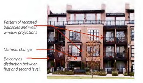


b. New building facades oriented to a publicly accessible street or open space shall include differentiation between the first and the upper levels with a canopy, balcony, arcade, or other architectural features.
c. If a project consists of more than one block face, each sequential block of new construction must contain a different building facade to encourage architectural variety within large projects, using the required architectural elements listed in subsection (g)(3)a above and/or other architectural features.
(3) Fenestration.
Intent: Providing fenestration encourages interaction between the pedestrian and the ground-story space. The intent of requiring clear fenestration is to allow pedestrians to view activities inside the building or displays related to those activities.
a. New single use commercial and mixed-use building facades fronting publicly accessible street or open space shall meet the following requirements:
Project Type | Fenestration Requirement |
Primary and Secondary Streets |
Project Type | Fenestration Requirement |
Primary and Secondary Streets | |
Mixed-Use and Commercial | |
Ground story (2'-12' above grade) | 40% |
Upper stories | 25% |
Residential | |
Ground story (2'-12' above grade) | None |
Upper stories | None |
b. Clear glazing shall have a visible transmittance rating of 0.5 or greater to count towards the fenestration requirement.
c. The following alternatives may count towards a portion of the fenestration requirement and can be used in singular or in combination. Alternatives may count no more than 50% of the total fenestration requirement.
Alternative | Percentage of Alternative Counting Towards Total Requirement |
Windows at the ground story but outside the 2-12' zone | 40% |
Wall mounted or recessed display cases at least 4' high | 40% |
Walk-up automated teller machines, video rental or similar kiosk | 40% |
Translucent, fritted, patterned, or color glazing | 40% |
Energy efficient windows that do not meet the .5 transmittance requirement | 40% |
Outdoor dining/seating located between the building and street | 60% |
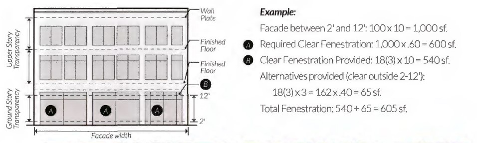

(4) Building materials. Not less than 70% of all new building facades (not including door and window areas) facing publicly accessible streets or open space shall be constructed of the following masonry materials:
a. Stone.
b. Brick.
c. Terra cotta.
d. Patterned pre-cast concrete.
e. Cement plaster stucco.
f. Cement board siding.
g. Cast stone or prefabricated brick panels.

(5) Building entries.
Intent: The intent of building entries is to create a pedestrian-oriented development in which buildings are oriented toward publicly accessible streets and sidewalks.
a. The principle building must have its main entrance from a public sidewalk or plaza, or from a private sidewalk or plaza that is publicly accessible through a public use easement. Interior buildings constructed as part of a campus development are exempt from these requirements (see Section (d)(4)c Campus Development).
b. Primary entrances shall not be from a parking lot.
c. Secondary entrances from parking lots are permitted.
d. All public building entrances for commercial developments and primary entrances for residential units must incorporate arcades, roofs, porches, alcoves, or awnings that protect pedestrians from the sun and rain.

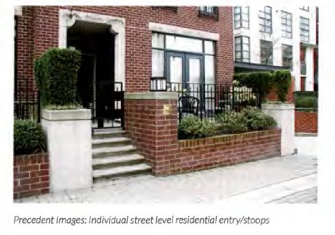
e. Residential entries.
1. Apartments, condominiums, and manor houses with street level units must provide individual street-oriented entries for each unit along the primary street frontage.


2. Apartments and condominiums must provide primary entrances at intervals not to exceed 125 linear feet of street-oriented building frontage. Entrance spacing is measured from the edge of door to the edge of the next door.
3. Townhouses must have individual street-oriented entries for each unit.
4. Manor houses must have a single primary entrance;
5. A duplex may have one primary entrance for each unit. Each primary entrance into a duplex must be provided under a shared porch or one of the entrances must be accessed from a side facade of the structure.
f. Commercial entries.
1. Each retail use with exterior ground level exposure along a street or public space shall have an individual public entry from the street or public space.
2. Entrances to corner buildings with ground floor retail uses shall be located at the corner of the primary street.
(h) Other development standards.
(1) Signs. In addition to the development standards in Chapter 6, Article 4
, the following provisions apply:
a. In addition to signs allowed in Chapter 6, Article 4, one or more attached project identifier or wayfinding signs may be erected on each facade of the occupied space.
Note: Doors and windows shall be included in the calculation of the facade area.
1. Signs may have a total area of 10% of the area of the facade to which the signs are attached, with a maximum aggregate area of 500 square feet per facade.
2. The facade area shall be calculated by multiplying the width times the height, with a maximum calculated height of 15 feet.
3. For structures exceeding 15 feet in height, allowable sign square footage shall be calculated as 0.75 square feet per linear foot of building facade.
(2) Fences, gates, and walls.
a. Complexes with perimeter security fencing along public streets are prohibited.
b. Fences shall not be located in the area between the front building facade and public street frontage or public open space.
c. Exterior fences and gates that are located along public streets, along private streets or walkways that are publicly accessible through a public use easement, or along publicly accessible open space shall not extend beyond building facades.
d. All fences and walls along public street frontage or public open space that are taller than four feet must be open style.
e. All fences and railings must be architecturally compatible with the character of the building and be constructed of high-quality materials including: wrought iron, composite fencing, treated wood, aluminum, or metal. Chain link, barbed wire, and concertina wire material is prohibited.


f. All walls must be architecturally compatible with the character of the building and constructed of high-quality materials including stone, decorative blocks, brick, cast stone, or stucco over standard concrete masonry blocks.
g. For a private residential patio or yard, or a commercial outdoor dining area, a fence, railing, or low wall may extend beyond the building facade if the following requirements are met:
1. Fences, railings, and walls must not exceed four feet (48") in total height as measured from the ground to the top of the fence, railing and/or the wall however;
2. For elevated residential stoops the total fence, railing and/or wall height must not exceed five feet (60") total.
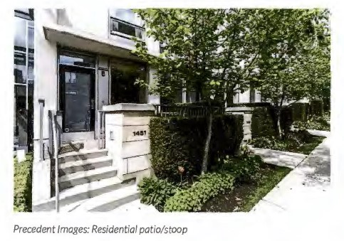
(3) Service areas screening.
a. Trash and recycling collection, and other similar service areas, must be located to the side or rear of buildings and behind the primary structures on street frontages.
b. All refuse and recycling collection containers for apartments/condominiums must be located on a concrete pad and shall be screened on three sides by an opaque fence or wall. The fourth side must be an opaque gate.
c. The design, colors, and materials of screening elements shall be architecturally compatible with the character of the building.


(4) Mechanical equipment screening.
Alternative | Fully Screened from Public Right-of- Way (Alleys excluded) | Permitted Screening Materials | ||
Landscaping | Opaque Wall/Fence | Architectural Screening Element | ||
Wall-Mounted | • | • | •2 | |
Roof-Mounted | •1 | • | ||
Ground- Mounted | • | • | •2 | |
1 Must be screened from abutting properties and the public street. 2 If an opaque wall or fence if provided, it shall be compatible with the principal building in terms of texture, quality, material, and color. | ||||


(5) Privately owned streets and drives with public access easements. Private streets and drives with public access easements shall be considered public streets or right-of-way for the purpose of review for compliance with setbacks, pocket parks, parking, screening, enhanced landscaping, facade variations, fenestration, and other MU-2 design requirements normally based on streets.
(6) Drive-in businesses.
a. Drive-in businesses may be permitted in accordance with the use tables in Chapter 4, Articles 6 and 8, provided that no such use shall be permitted to sell alcoholic beverages for consumption on the premises. In the MU-2 district the following requirements shall apply:
1. Drive-through windows and stacking lanes shall not be located along facades of buildings that face a street, and where possible shall be located to the rear of buildings;
2. Driveways shall not be located within the front yard setback between the building front and the street;
3. The design and location of the facility shall not impede vehicular traffic flow and shall not impede pedestrian movement and safety. To minimize conflicts with vehicular and pedestrian circulation, shared driveways and/or driveways located off of non-arterial streets shall be used, where possible;
4. Architectural elements, landscaping and/ or other screening elements shall be provided to minimize the visual impacts of the drive-through facility; and
5. The design and location of the facility hall be consistent with any design standards or guidelines that may be applicable to the pertinent district.
(Ord. 20159-04-2012, § 1 (Exh. A), passed 4-3-2012; Ord. 21782-07-2015, § 3, passed 7-16-2015, eff. 7-26-2015; Ord. 22810-08-2017, § 1 (Exh. B), passed 8-1-2017, eff. 9-7-2017; Ord. 23648-05-2019, §§ 1, 2, 4-11 passed 5-7- 2019; Ord. 24030-02-2020, § 22, passed 2-4-2020; Ord. 25189-11-2021, § 1, passed 11-9- 2021, eff. 12-16-2021; Ord. 26920-05-2024, § 1, passed 5-14-2024, eff. 7-16-2024)
Editor’s note:
Ord. 22810-08-2017, § 3, adopted August 1, 2017, repealed § 4.1303, derived from Ord. 20159-04-2012, § 1 (Exh. A), passed April 3, 2012, amended by Ord. 21782-07- 2015, § 4, passed July 16, 2015, which pertained to the High Intensity Mixed-Use (“MU- 2G”) District. See also the Code Comparative Table.
(a) Purpose and intent. It is the purpose of the Panther Island (“PI”) district to provide a specific mixed-use development zone that encourages pedestrian-oriented, urban development in the Panther Island area, and to provide development standards and administrative procedures that encourage high-quality, sustainable development and creative design.
(b) Uses. In the Panther Island (“PU”) district, no building or land shall be used and no building shall be hereafter erected, reconstructed, altered or enlarged, nor shall a certificate of occupancy be issued, except in accordance with the use tables and supplemental standards contained in § G. of the document Panther Island Form Based Zoning District Zoning Standards and Guidelines an adopted supplement to the city’s zoning ordinance.
(c) Property development standards.
(1) The minimum dimension of lots and yards and the height of buildings in the Panther Island (“PI”) district, shall be as shown in the accompanying table. Development in this district shall be exempt from all other zoning ordinance regulations not contained within the accompanying table or the document Panther Island Form Based Zoning District Zoning Standards and Guidelines.
(2) The development standards may only be applied to that area known as the Panther Island district of Fort Worth boundary described as follows and shown in Exhibit B.17:
A parcel of land out of the A. Gouehenant Survey, Abstract No. 582, the M. Baugh Survey, Abstract No. 106, the J. Baugh Survey, Abstract No. 115, the F. G. Mulliken Survey, Abstract No. 1045, and the A. Robinson Survey, Abstract No. 1289, in Tarrant County, Texas, being more particularly described by metes and bounds as follows:
BEGINNING at the intersection of the centerlines of Commerce Street and Weatherford Street;
THENCE with the centerline of Weatherford Street, North 60 degrees East, 270 feet to its intersection with the centerline of Calhoun Street;
THENCE with the centerline of Calhoun Street, North 30 degrees West, 280 feet to its intersection with the centerline of Belknap Street;
THENCE with the centerline of Belknap Street, North 60 degrees East, 780 feet to its intersection with the centerline of Pecan Street;
THENCE with the centerline of Pecan Street, North 30 degrees West, 270 feet to its intersection with the centerline of Bluff Street;
THENCE with the centerline of Bluff Street, South 60 degrees West, 97 feet to its intersection with the extension of the southwesterly property line of Lot 4R, Block 1 of Trinity Bluff, being an addition to the City of Fort Worth according to the plat recorded in Cabinet B, Slide 3356 of the Plat Records of Tarrant County, Texas (P.R.T.C.T.);
THENCE Northwesterly with the extension of the said southwesterly property line to its intersection with the centerline of the West Fork of the Trinity River;
THENCE Northerly with the meanders of said river centerline to its intersection with the south right-of-way line of Greer Street projected west;
THENCE Easterly, to and along the south right-of-way line of the said Greer Street, to its intersection with the east property line of Lot 5 of S. Terrell Addition, being an addition to the City of Fort Worth according to the plat recorded in Volume 1624, Page 274 of the Deed Records of Tarrant County, Texas, (D.R.T.C.T.), extended south;
THENCE Northerly, to and along the east property line of the said Lot 5, to the northeast property corner of the said Lot 5;
THENCE Northerly to the southeast corner of the Baldemar Lane street right-of-way;
THENCE Northerly, along the east right-of-way line of the said Baldemar Lane and then along the said right-of-way line extended north to the southeast property corner of Lot 9-RB of North Park Business Center, being an addition to the City of Fort Worth according to the plat recorded in Volume 388-124, Page 77 of the (P.R.T.C.T.);
THENCE Northerly, along the east property line of the said Lot 9-RB to a point on the north property line of Lot 2 of Holloway’s Addition, being an addition to the City of Fort Worth according to the plat recorded in Volume 1530, Page 373 of the (D.R.T.C.T.);
THENCE Easterly, along the north property line of the said Lot 2 to a point on the west right-of-way line of Samuels Avenue;
THENCE Northerly, along the west right-of-way line of said Samuels Avenue to its intersection with the south right-of-way line of North Park Drive;
THENCE Westerly, along the south right-of-way line of North Park Drive, to the northwest property corner of Lot 10-RA of the said Northpark Business Center Addition, said point also being on the east right-of-way line of an existing 75 foot wide Texas Electric Service Co. right-of-way (T.E.S.Co. R.O.W.);
THENCE Southerly, along the east right-of-way line of the said T.E.S.Co. R.O.W. to the southwest property corner of the said Lot 10-RA;
THENCE Northwesterly, to the southeast property corner of Lot 11-A of Northpark Business Center, being an addition to the City of Fort Worth according to the plat recorded in Volume 388-218, Page 37 of the (P.R.T.C.T.);
THENCE Northerly, along the west right-of-way line of said T.E.S.Co. R.O.W. to its intersection with the southwest right-of-way line of North Park Drive;
THENCE Northwesterly, along the southwest right-of-way line of said North Park Drive to the northwest property corner of Lot 11-B of the said Northpark Business Center Addition;
THENCE South 10 degrees 08 minutes West, 1043 feet to a point in the centerline of the West Fork of the Trinity River;
THENCE North, 61 degrees 53 minutes 19 seconds West, with the said river centerline, 320.55 feet to a point;
THENCE North, 42 degrees 28 minutes 14 seconds West, with the said river centerline, 704.18 feet to a point at the beginning of a curve to the left having a radius of 183.55 feet;
THENCE in the westerly direction along the said curve through an arc length of 320.21 feet and across a chord which bears South 82 degrees 47 minutes 01 seconds West 281.12 feet to point on the centerline of the proposed Trinity River by-pass channel;
THENCE Southerly, along the centerline of the said proposed Trinity River by-pass channel to its intersection with the centerline of the Clear Fork of the Trinity River;
THENCE Northeasterly, along the centerline of the said Clear Fork of the Trinity River, 1,126.42 feet to a point;
THENCE South 29 degrees 52 minutes 13 seconds east 346.15 feet to a point;
THENCE South 85 degrees 07 minutes 25 seconds East 348.96 feet to a point;
THENCE North 59 degrees 20 minutes 26 seconds East to the centerline of Lexington Street;
THENCE Southeasterly, along the centerline of said Lexington Street to its intersection with the centerline of Bluff Street;
THENCE Northeasterly, along the centerline of Bluff Street to its intersection with the centerline of Henderson Street;
THENCE North 30 degrees 11 minutes 24 seconds West, along the centerline of Henderson Street, at 249.16 feet passing the intersection of the centerline of Peach Street extended, continuing in all a total distance of 317.61 feet to a point;
THENCE North 58 degrees 46 minutes 38 seconds East 254.82 feet to a point;
THENCE North 30 degrees 20 minutes 09 seconds West 46.79 feet to a point;
THENCE North 20 degrees 59 minutes 49 seconds West 629.42 feet to a point in the centerline of proposed Lexington Street;
THENCE Easterly, with the centerline of proposed Lexington Street to its intersection with the centerline of North Main Street;
THENCE South 30 degrees 24 minutes 58 seconds East, along the centerline of North Main Street 326.66 feet to a point;
THENCE North 60 degrees 12 minutes 03 seconds East 321.00 feet to the centerline of Commerce Street;
THENCE Southeasterly, with the centerline of Commerce Street to the Point of Beginning.
Core Zones are more particularly described as follows:
UL 3 West (UL3)
A parcel of land out of the A. Gouehenant Survey, Abstract No. 582, Tarrant County, Texas, being more particularly described by metes and bounds as follows:
BEGINNING at the intersection of the centerline of 5th Street and the centerline of Street 12;
THENCE Northeasterly along the said centerline of 5th Street to the centerline of Street 11;
THENCE Southeasterly along the said centerline of Street 11 to the centerline of proposed Canal “B;”
THENCE Southwesterly along the said centerline of proposed Canal “B” to the centerline of West Fork of the Trinity River;
THENCE Northwesterly along the said centerline of the West Fork of the Trinity River to the centerline of proposed Canal “A;”
THENCE Southwesterly along the said centerline of proposed Canal “A” to the said centerline of Street 12;
THENCE Northwesterly along the said centerline of Street 12 to the Point of Beginning.
East (UL3)
A parcel of land out of the A. Gouhenant Survey, Abstract No. 582, Tarrant County, Texas, being more particularly described by metes and bounds as follows:
BEGINNING at the intersection of the centerline of 5th Street and the centerline of Street 12;
THENCE Northeasterly along the said centerline of 5th Street to the centerline of Street 11;
THENCE Southeasterly along the said centerline of Street 11 to the centerline of proposed Canal “B;”
THENCE Southwesterly along the said centerline of proposed Canal “B” to the centerline of the West Fork of the Trinity River;
THENCE Northwesterly along the said centerline of West Fork of the Trinity River to the centerline of proposed Canal “A;”
THENCE Southwesterly along the said centerline of proposed Canal “A” to the said centerline of Street 12;
THENCE Northwesterly along the said centerline of Street 12 to the Point of Beginning.
UL-2
A parcel of land out of the M. Baugh Survey, Abstract No. 582, Tarrant County, Texas, being more particularly described by metes and bounds as follows:
BEGINNING at the intersection of the centerline of North Main Street and the centerline of proposed Canal “B;”
THENCE Southeasterly along the said centerline of Main Street to the centerline of the West Fork of the Trinity River;
THENCE Westerly along the said centerline of the West Fork of the Trinity River to the centerline of the Clear Fork of the Trinity River;
THENCE Southwesterly along the said centerline of Clear Fork of the Trinity River to the centerline of Street 13;
THENCE Northwesterly along the said centerline of Street 13 to the centerline of proposed Canal “A;”
THENCE Northeasterly along the said centerline of Canal “A” to the said centerline of the West Fork of the Trinity River;
THENCE Southeasterly along the said centerline of the West Fork of the Trinity River to the said centerline of proposed Canal “B;”
THENCE Northeasterly along the said centerline of Canal “B” to the said centerline of the Point of Beginning.
UL-1
A parcel of land out of the A. Robinson Survey, Abstract No. 1289, Tarrant County, Texas, being more particularly described by metes and bounds as follows:
BEGINNING at the intersection of the centerline of Henderson Street and the centerline of proposed Lexington Street North;
THENCE Easterly along the said centerline of Lexington Street 516.11 feet to a point;
THENCE South 20 degrees 59 minutes 49 seconds east 629.42 feet to a point;
THENCE South 30 degrees 20 minutes 09 seconds East 46.79 feet to a point;
THENCE South 58 degrees 46 minutes 38 seconds West 254.82 feet to the centerline of Henderson Street;
THENCE Northwesterly along the said centerline of Henderson Street to the Point of Beginning.
North Main (NM)
A parcel of land out of the Felix G. Mulliken Survey, Abstract No. 1045, A. Gouhenant Survey, Abstract No. 582, Tarrant County, Texas, being more particularly described by metes and bounds as follows:
BEGINNING at the intersection of the centerline of 7th Street and the centerline of Street 10;
THENCE Northeasterly along the said centerline of 7th Street to the centerline of Commerce Street;
THENCE Southeasterly along the said centerline of Commerce Street to the centerline of proposed Canal “B;”
THENCE Southwesterly along the said centerline of proposed Canal “B” to the centerline of Street 11;
THENCE Northwesterly along the said centerline of Street 11 to the centerline of 5th Street;
THENCE Northeasterly along the said centerline of 5th Street to the said centerline of Street 10;
THENCE Northwesterly along the said centerline of Street 10 to the Point of Beginning.
Neighborhood Tower Zones N3
South (N3)
A parcel of land out of the R. Crowley Survey, Abstract No. 313, and the W. Russell Survey, Abstract No. 151, Tarrant County, Texas, being more particularly described by metes and bounds as follows:
BEGINNING at the intersection of the centerline of Henderson Street and the centerline of proposed Canal “A;”
THENCE Southerly along the said centerline of proposed Canal “A” to the centerline of the Clear Fork of the Trinity River;
THENCE Southwesterly along the said centerline of the Clear Fork of the Trinity River to the centerline of the proposed Trinity River by-pass channel;
THENCE Northerly along the said centerline of the by-pass channel to the said centerline of Henderson Street;
THENCE Southeasterly along the said centerline of Henderson Street to the Point of Beginning.
North (N3)
A parcel of land out of the Felix G. Mulliken Survey, Abstract No. 1045, Tarrant County, Texas, being more particularly described by metes and bound as follows:
BEGINNING at the intersection of the centerline of the proposed 7th Street and the centerline of the west Fork of the Trinity River;
THENCE Southwesterly along the said centerline of proposed Canal “D” to the centerline of 6th Street;
THENCE southeasterly along the said centerline of proposed Canal “D” to the centerline of 6th Street;
THENCE Southwesterly along the said centerline of 6th Street to the centerline of Commerce Street;
THENCE Northwesterly along the said centerline of Commerce Street to the centerline of the 8th Street;
THENCE Northeasterly along the said centerline of 8th Street to the centerline of Calhoun Street;
THENCE Northwesterly along the said centerline of Calhoun Street projected north to the centerline of the West Fork of the Trinity River;
THENCE Southeasterly along the said centerline of the West Fork of the Trinity River to the Point of Beginning.
Southeast (N3)
A parcel of land out of the A. Robinson Survey, Abstract No. 1289 and the W. Russell, Abstract No. 151, Tarrant County, Texas, being more particularly described by metes and bounds as follows:
BEGINNING at the intersection of the centerline of Henderson Street and the centerline of the Clear Fork of the Trinity River;
THENCE Southeasterly along the said centerline of Henderson Street to its intersection with the centerline of Bluff Street;
THENCE Southwesterly along the said centerline of Bluff Street to its intersection with the centerline of Lexington Street North;
THENCE North 29 degrees 58 minutes 55 seconds West, along the centerline of Lexington Street North, 399.15 feet to a point;
THENCE south 59 degrees 20 minutes 26 seconds West 36.98 feet to a point;
THENCE North 85 degrees 07 minutes 25 seconds West 348.96 feet to a point;
THENCE North 29 degrees 52 minutes 13 seconds West 316.15 feet to a point on the centerline of the Clear Fork of the Trinity River;
THENCE Northeasterly along the said centerline of Clear Fork of the Trinity River to the Point of Beginning.
N2 West (N2)
A parcel of land out of the W. Russell Survey, Abstract No. 151, the R. Crowley Survey, Abstract No. 313, the A. Gouehenant Survey, Abstract No. 582, the J. Baugh Survey, Abstract No. 115, and the F. Mulliken Survey, Abstract No. 1045, Tarrant County, Texas, being more particularly described by metes and bounds as follows.
BEGINNING at the intersection of the centerline of 7th Street and the centerline of Commerce Street;
THENCE Southwest along the said centerline of 7th Street to its intersection with the centerline of Street 10;
THENCE Southeast along the said centerline of Street 10 to its intersection with the centerline of 5th Street;
THENCE Southwest along the said centerline of 5th Street to its intersection with the centerline of Street 12;
THENCE Southeast along the said centerline of Street 12 to its intersection with the centerline of Canal “A;”
THENCE Southwest along the said centerline of Canal “A” its intersection with the centerline of Street 13;
THENCE Southeast along the said centerline of Street 13 to its intersection of Clear Fork of the Trinity River;
THENCE upstream in a southwest direction along the said centerline of the Clear Fork of the Trinity River to its intersection with the said centerline of Canal “A;”
THENCE Northwesterly along the said centerline of Canal “A” to its intersection with the centerline of Henderson Street;
THENCE Northwest along the said centerline of Henderson Street to its intersection with the centerline of the Trinity River by-pass channel;
THENCE North along the said centerline of the by-pass channel to its intersection with Calhoun Street projected North;
THENCE Southeast along the said projected centerline of Calhoun Street to its intersection with the centerline of 8th Street;
THENCE Southwest along the said centerline of 8th Street to its intersection with the centerline of Commerce Street;
THENCE Southeast along the said centerline of Commerce Street to the Point of Beginning.
East (N2)
A parcel of land out of the A. Gouehenant Survey, Abstract No. 582, the M. Baugh Survey, Abstract No. 106 and the Felix G. Mulliken Survey, Abstract No. 1045, Tarrant County, Texas, being more particularly described by metes and bounds as follows:
BEGINNING in the centerline Canal “B” at its intersection with the intersection of Commerce Street;
THENCE Northwest along the said centerline of Commerce Street to its intersection with the centerline of 6th Street;
THENCE Northeast along the said centerline of 6th Street to its intersection with the centerline of Street 3;
THENCE Northwest along the said centerline of Street 3 to its intersection with the centerline of 7th Street;
THENCE Northeast with the said centerline of proposed 7th Street to its intersection with the centerline of the West Fork of the Trinity River;
THENCE Southerly and upstream with the said centerline of the West Fork of the Trinity River to its intersection with the projected centerline of Canal “B;”
THENCE Westerly with the said centerline of Canal “B” to the Point of Beginning.
South (N2)
A parcel of land out of the A. Robinson Survey, Abstract No. 1289, Tarrant County, Texas, being more particularly described by metes and bounds as follows:
BEGINNING at the intersection of the centerline of Henderson Street and the centerline of proposed Lexington Street North;
THENCE Easterly along the said centerline of Lexington Street 516.11 feet to a point;
THENCE South 20 degrees 59 minutes 49 seconds east 629.42 feet to a point;
THENCE South 30 degrees 20 minutes 09 seconds East 46.79 feet to a point;
THENCE South 58 degrees 46 minutes 38 seconds West 254.82 feet to the centerline of Henderson Street;
THENCE Northwesterly along the said centerline of Henderson Street to the Point of Beginning.
Northeast (N2)
A parcel of land out of the Felix G. Mulliken Survey, Abstract No. 1045, Tarrant County, Texas, being more particularly described by metes and bounds as follows:
BEGINNING at the intersection of the centerline of the West Fork of the Trinity River and the south right-of-way line of Greer Street projected west;
THENCE easterly to and along the south right-of-way line of said Greer Street, to its intersection with the east property line of Lot 5 of S. Terrell Addition, being an addition to the City of Fort Worth according to the plat recorded in Volume 1624, Page 274 of the Deed Records of Tarrant County, Texas (D.R.T.C.T.), extended south;
THENCE Northerly to and along the east property line of the said Lot 5, to the northeast property corner of the said Lot 5;
THENCE Northerly to the southeast corner of the Baldemar Lane street right-of-way;
THENCE Northerly along the east right-of-way line of said Baldemar Lane and then along the south right-of-way line extended north to the southeast property corner of Lot 9-RB of North Park Business Center, being an addition to the City of Fort Worth according to the plat recorded in Volume 388-124, Page 77 of the (P.R.T.C.T.);
THENCE Northerly along the east property line of the said Lot 9-RB to a point on the north property line of Lot 2 of Holloway’s Addition, being an addition to the City of Fort Worth according to the plat recorded in Volume 1530, Page 373 of the (D.R.T.C.T.);
THENCE Easterly along the north property line of the said Lot 2 to a point on the west right-of-way line of Samuels Avenue;
THENCE Northerly along the west right-of-way line of said Samuels Avenue to its intersection with the south right-of-way line of North Park Drive; Thence Westerly along the south right-of-way line of North Park Drive, to the northwest property corner of Lot 10-RA of the said North Park Business Center Addition, said point also being on the east right-of-way line of an existing 75 foot wide Texas Electric Service Co. right-of-way (T.E.S.Co. R.O.W.);
THENCE Southerly along the east right-of-way of the said (T.E.S.Co. R.O.W.) to the southwest property corner of the said Lot 10-RA;
THENCE Northwesterly to the southeast property corner of Lot 11-A of Northpark Business Center, being an addition to the City of Fort Worth according to the plat recorded in Volume 388-218, Page 37 of the P.R.T.C.T.;
THENCE Northerly along the west right-of-way line of said (T.E.S.Co. R.O.W.) to its intersection with the southwest right-of-way line of North Park Drive;
THENCE Northwesterly along the southwest right-of-way line of North Park Drive to the northwest property corner of Lot 11-B of the said Northpark Business Center Addition;
THENCE South 10 degrees 08 minutes West 1,043 feet to a point in the centerline of the West Fork of the Trinity River;
THENCE Southeasterly along the said centerline of the West Fork of the Trinity River to the Point of Beginning.
N1
A parcel of land in the A. Gouehenant Survey, Abstract No. 582, and the M. Baugh Survey, Abstract No. 106, Tarrant County, Texas, being more particularly described by metes and bounds as follows:
BEGINNING at the intersection of the centerline of North Main Street and the centerline of the West Fork of the Trinity River;
THENCE Northerly along the centerline of North Main Street to the centerline of the proposed Canal “B” as shown on the Trinity Uptown Zoning Map;
THENCE Easterly along the centerline of proposed Canal “B” to the centerline of the West fork of the Trinity River;
THENCE upstream along the centerline of the West Fork of the Trinity River in a southerly direction to the Point of Beginning.
LaGrave Field (LF)
A parcel of land out of the Felix G. Mulliken Survey, Abstract No. 1045, Tarrant County, Texas, being more particularly described by metes and bounds as follows:
BEGINNING at the intersection of the centerline of 7th Street and the centerline of proposed Canal “D;”
THENCE Northeasterly along the said centerline of 7th Street to the centerline of Street 3;
THENCE Southeasterly along the said centerline of Street 3 to the centerline of 6th Street;
THENCE Southwesterly along the said centerline of 6th Street to the said centerline of proposed Canal “D;”
Thence Northwesterly along the said centerline of Canal “D” to the Point of Beginning.
Tarrant County College (TCCD)
A parcel of land out of the M. Baugh Survey, Abstract No. 106, Tarrant County, Texas, being more particularly described by metes and bounds as follows:
BEGINNING at the intersection of the centerlines of Commerce Street and Weatherford Street; Thence Northeasterly with the centerline of Weatherford Street to its intersection with the centerline of Calhoun Street;
THENCE Northwesterly with the centerline of Calhoun Street to its intersection with the centerline of Belknap Street;
THENCE Northeasterly with the centerline of Belknap Street to its intersection with the centerline of Pecan Street;
THENCE Northwesterly with the centerline of Pecan Street to its intersection with the centerline of Bluff Street;
THENCE Southwesterly with the centerline of Bluff Street to its intersection with the extension of the southwest property line of Lot 4R, Block 1 of Trinity Bluff, being an addition to the City of Fort Worth according to the plat recorded in Cabinet B, Slide 3356 of the Plat Records of Tarrant County, Texas (P.R.T.C.T.);
THENCE Northwesterly with the extension of the said southwesterly property line to its intersection with the centerline of the West Fork of the Trinity River;
THENCE upstream along the centerline of the West Fork of the Trinity River in a Southerly direction to the centerline of North Main Street;
THENCE Southeasterly with the centerline of North Main Street to its intersection with East Bluff Street;
THENCE Northwesterly with the centerline of E. Bluff Street to its intersection with Commerce Street;
THENCE Southeasterly with the centerline of Commerce Street to the Point of Beginning.
Panther Island (“PI”) District
|
Panther Island (“PI”) District
| |
Front build-to range* | 80% of a building’s front facade must be located within 10 feet of the property line |
Waterfront build-to range* | 80% of a building’s front facade must be located no closer than 5 feet and no farther than 15 feet from the property line |
Rear yard* | 5 feet minimum |
Side yard* | None required; if provided, must be minimum of three feet and maximum of 10 feet |
Units per acre | No restriction |
Units per building | No restriction |
Building height range** | LaGrave Field Zone |
Minimum 5 floors; Maximum 72 feet | |
Neighborhood Zones N-1 | |
Minimum 5 floors; Maximum 72 feet | |
Neighborhood Zones N-2 - North and South | |
Minimum 5 floors; Maximum 96 feet | |
Neighborhood Tower Zones N-3 - North, Central and South | |
Minimum 6 floors; Maximum 288 feet | |
Urban Lake Zone 1 | |
Minimum 2 floors; Maximum 36 feet | |
Urban Lake Zone 2 | |
Minimum 5 floors; Maximum 72 feet | |
Urban Lake Zone 3 | |
Minimum 5 floors; Maximum 96 feet | |
North Main Zone | |
Minimum 5 floors; Maximum 20 floors | |
Tarrant County College District Zone | |
Minimum 5 floors; Maximum 72 feet | |
Notes: | |
* Additional setback standards and guidelines contained in Panther Island Form Based Zoning District Zoning Standards and Guidelines | |
** See core zone boundary map in Appendix B and Panther Island Form Based Zoning District Standards and Guidelines. | |
(d) Other development standards.
(1) Generally. Development in the Panther Island (“PI”) district is subject to the development standards and guidelines contained in the Panther Island Form Based Zoning District Zoning Standards and Guidelines document. Panther Island Form Based Zoning District Zoning Standards and Guidelines are hereby approved by the city council and are included in the zoning ordinance by reference. All future amendments to the Panther Island Form Based Zoning District Zoning Standards and Guidelines must be considered by the zoning commission and approved by the city council in accordance with the procedure set out in Article 5, Chapter 3.
(2) Metal buildings. The exterior metal walls of the front and any sides of a building facing a public street shall not be constructed with exposed fasteners on more than 50% of the building. All buildings with metal siding shall have at least two exterior architectural features for articulation, such as front porches, gables, awning or other exterior siding materials. Exterior metal siding shall not be considered an architectural feature. These provisions shall not apply to large retail stores.
(e) Development review process.
(1) Certificate of appropriateness. Within the Panther Island (“PI”) district, issuance of a certificate of appropriateness reflecting compliance with the Panther Island Form Based Zoning District Zoning Standards and Guidelines is required as outlined in subsection (e)(2) below.
(2) Certificate of appropriateness required. Within the Panther Island district, issuance of a certificate of appropriateness reflecting compliance the Panther Island Form Based Zoning District Zoning Standards and Guidelines is required as a condition of the following:
a. Acceptance by the planning and development department of an application for a building permit for construction of a new structure;
b. Acceptance by the planning and development department of an application for a building permit for expansion of an existing structure;
c. Acceptance by the planning and development department of an application for a building permit for renovation, remodeling or other alteration of an existing structure; and
d. Construction of a surface parking lot.
(3) Pre-design conference. A pre-design conference with the planning and development department director or a designee is required before an applicant makes application for a certificate of appropriateness. Two copies of a site plan containing the following information shall be submitted to the development services director for discussion at the pre-design conference:
a. Footprints of all existing structures;
b. Proposed footprints of all new structures;
c. Existing structures adjacent to the property;
d. Existing and proposed floor plans (schematic drawings);
e. Building setbacks;
f. Location of parking areas;
g. Location of landscape areas;
h. Two copies of building elevations for all sides of the building(s); and
i. Photographs of the site and adjoining properties.
(4) Application for certificate of appropriateness. The following materials shall be submitted to the planning and development department in connection with an application for a certificate of appropriateness. The materials must be submitted at least 21 days before the meeting of the urban design commission at which the application for a certificate of appropriateness will be considered:
a. Nine copies of site plan including:
1. Footprints of all existing structures;
2. Proposed footprint of all new structures;
3. Existing structures adjacent to the property;
4. Building setbacks; and
5. Location of parking areas, parking lot islands, driveways, sidewalks, walkways, loading areas, walls or fences, utilities, lighting, signage, at-grade mechanical units, dumpsters and all other site improvements.
b. Nine copies of landscape plan including location and dimension of areas to be landscaped (including private property, adjoining right-of-way and parking lot islands), total amount of landscaped area, location, number and planting size of all trees, shrubs and groundcover, location and coverage of irrigation system and location and description of street furniture;
c. Nine copies of schematic floor plans depicting the arrangement of interior spaces, location of windows and doors, mechanical equipment, electrical meter and utility locations. First floor site plans should show the relationship between the first floor and the site;
d. Nine copies of schematic building elevations for all sides of the building(s) showing design of all elevations, existing grade, proposed grade, finish floor elevations, roof slopes, mechanical vents and equipment, location and type of outdoor light fixtures, design and location of all wall sign(s) and notations regarding exterior colors and material;
e. Material specification outline with samples, brochures and/or photographs of all exterior and site materials, finishes and fixtures; and
f. For all detached signs, nine site plans drawn to scale indicating sign location and drawings of proposed sign, lettering and graphics, drawn to scale of at least one-quarter-inch to the foot including any support structures. Colors of the proposed sign shall be indicated on the drawing and actual color samples shall be furnished. Any proposed illumination shall be indicated on the drawing.
(5) Authority to approve certificate of appropriateness. The urban design commission is hereby charged with the duty and invested with the authority to:
a. Enforce the Panther Island Form Based Zoning District Zoning Standards and Guidelines for new construction and renovations by hearing and deciding applications for certificates of appropriateness in accordance with this section; and
b. Propose amendments to the Panther Island Form Based Zoning District Zoning Standards and Guidelines to the zoning commission and city council from time to time.
(6) Appeal.
a. Appeals board. All decisions by the urban design commission may be appealed to the board of adjustment by the applicant. A written notice of appeal must be filed with the city secretary within ten days after receipt of notification of the urban design commission’s decision. The written notice of appeal shall specify:
1. That the decision of the board is unreasonable, either in whole or in part; and
2. The grounds for the appeal.
b. Hearing. The board of adjustment shall schedule a hearing on such appeal within 30 days after receipt of the notice of appeal, or as soon thereafter as reasonably practicable. The secretary of the urban design commission shall forward to the board of adjustment a complete record of the matter, including a transcript of the tape of the hearing before the urban design commission. In consideration of an appeal, the appeal boards shall:
1. Hear and consider testimony and evidence concerning the previous recommendations and actions of the city staff and the urban design commission;
2. Hear new testimony and consider new evidence that was not available at the time of the hearing before the urban design commission;
3. Apply the substantial evidence test to the decision of the urban design commission; and
4. Have to options to remand any case back to the urban design commission for further proceedings.
c. Decision. The board of adjustment may uphold, reverse or modify the decision of the urban design commission unless a continuance is agreed to by the owner/appellant.
d. Administrative remedies. A hearing before the board of adjustment shall exhaust the administrative remedies of the property owner/appellant under this title. Any owner/appellant aggrieved by the decision of the board of adjustment may file in district court.
(Ord. 19268, passed 8-10-2010, eff. 9-4-2010; Ord. 20159-04-2012, § 1 (Exh. A), passed 4-3-2012; Ord. 21272-06-2014, § 5, passed 6-3-2014; Ord. 22336-08-2016, §§ 1 and 2, passed 8-2-2016; Ord. 23886-10-2019, § 2, passed 10-15-2019, eff. 11-7-2019; Ord. 24030-02-2020, § 22, passed 2-4-2020; Ord. 26877-04-2024, §§ 1, 2, passed 4-23-2024, eff. 7-12-2024)
Loading...