Loading...
(a) Purpose and intent. It is the purpose of the medium density multifamily ("C") district to provide a specific zone for medium density multifamily development. In adopting multifamily design development regulations, it is also the intent of the City Council to encourage the most appropriate uses of land; to encourage higher quality design and materials; to provide safe and improved access to the public walkways; to install street trees and enhanced landscaping along public walkways to improve the pedestrian environment; and to provide criteria for development of land zoned for multifamily dwelling use.
(b) Uses. In the medium density multifamily ("C") district, no building or land shall be used and no building shall be hereafter erected, reconstructed, altered or enlarged, nor shall a certificate of occupancy be issued, except in accordance with the use tables in Chapter 4, Articles 6 and 8 and the supplemental use standards of Chapter 5. No permit shall be issued for construction, alteration or revision for multifamily development unless there has been a site plan approved by the development services director or an authorized representative.
(c) Property development standards.
(2) a. All multifamily residential development (three or more dwelling units) shall meet the property development standards of § 6.506, Multifamily Design Development and the minimum dimension of lots and yards shall be as shown in the accompanying table.
“C” District, Multifamily Development
|
“C” District, Multifamily Development
| |
Open space | 45% minimum |
Units per acre | 24 maximum |
Front yard* | 20 feet minimum |
Rear yard | 5 feet minimum |
Side yard* | |
Interior lot | 5 feet minimum |
Corner lot ** | 20 feet minimum adjacent to side street |
Setback adjacent to one- or two-family residential district *** | Three feet for every one foot (3:1) as measured from slab to top of sill plate, or two feet for every one foot (2:1) in overall height when measured from lowest finished grade to the peak of the roof, whichever is greater; 30 feet minimum 1:1 setback with a 10-foot minimum setback for one-story garages and carports 20-foot minimum setback for dumpster enclosures and one-story accessory structures |
Height | |
Notes: | |
*** A five-foot bufferyard and minimum six-foot screen fence shall be placed on the property line and should be landscaped per point system, see § 6.300 (b), (d), (f), (g). This regulation shall not be required when the property in the one- or two-family district is used for utilities, waterways, railroads or other nonresidential public use or separated by a public right-of-way of at least 300 feet in width. | |
“C” District, Nonresidential Development
|
“C” District, Nonresidential Development
| |
Lot width | 50 feet minimum |
Front yard* | 20 feet minimum |
Rear yard | 5 feet minimum |
Side yard* | |
Interior lot | 5 feet minimum |
Corner lot ** | 10 feet minimum adjacent to side street |
Setback adjacent to one- or two-family residential district*** | 20 feet minimum |
Height | |
Notes: | |
*** A five-foot bufferyard and minimum six-foot screen fence shall be placed on the property line and should be landscaped per point system, see § 6.300 (b), (d), (f), (g). This regulation shall not be required when the property in the one- or two-family district is used for utilities, waterways, railroads or other nonresidential public use or separated by a public right-of-way of at least 300 feet in width. | |
(d) Other development standards. Development in the medium density multifamily ("CR") district may be subject to a variety of general development standards, including, but not limited to the following.
(1) Signs.
a. For non-multifamily development on-premises signs are subject to the following:
i. An unilluminated nameplate bearing the family name of the occupants residing in the residence not to exceed one square foot in area; and
ii. An unilluminated sign for those uses permitted that are not residential. The sign shall not exceed 30 square feet in area, shall be no higher than six feet above grade and shall be placed a minimum of ten feet behind the property line. Such sign shall not be placed within 20 feet of drives providing ingress and egress to the property.
b. Identification signs for multifamily development shall be permitted, subject to the following provisions:
i. Signs shall be permitted to identify the use or uses of the property upon which displayed.
ii. A sign or combination of signs shall have a maximum allowable area of exposure on each dedicated street frontage of not more than one square foot of sign area for each ten linear feet of frontage along said street; provided, however, at least one sign shall be allowed having an area of 12 square feet.
iii. Signs may be illuminated, but the source of light shall not be visible and shall not be intermittent or flashing; revolving signs shall not be permitted.
iv. Not more than 50% of the total allowable sign area may be located in the required yard space along a dedicated street. However, no individual sign in such required yard space shall exceed 20 square feet in sign area.
v. Symbols which are designed as an integral part of the building structure and symbols and signs which are not visible or readable from the public street shall not be limited by the above regulations.
vi. Nothing contained herein shall exempt the owner of any multifamily building from placing identification signs on buildings as required by the City of Fort Worth fire code.
(2) Parking.
a. One- and two-family residential development shall meet the parking requirements for the selected district.
c. Multifamily development parking requirements shall be as follows:
i. No parking or driveways shall be provided between a building and a public or private street. Parking shall be provided per § 6.201. Frontage on a controlled access highway shall not be considered a street for purposes of this section.
Use | Requirement |
Multifamily Residential | 1 space per bedroom plus 1 space per 250 square feet of common areas, offices and recreation (less laundry rooms and storage); 2 spaces may be tandem if assigned to the same unit and restricted from use for storage. |
Multifamily Residential: Townhouse configuration | Two spaces per dwelling unit, located within a garage of the individual unit, having access to and from that unit, and not accessible or usable by other residential units. Plus 1 space per 250 square feet of common areas, offices and recreation (less laundry rooms and storage). |
ii. On-street parking along the lot frontage may be applied toward the minimum parking requirements only when located fully out of the travel lanes as defined in the Master Thoroughfare Plan when there is parking on both sides of the street. On-street parking that is applied toward minimum parking requirements shall be counted towards the maximum parking limitations.
(3) Accessory uses in Multifamily Design developments. In addition to other uses which qualify as accessory uses, the following shall be considered as accessory uses to Multifamily Design development:
a. Recreation areas and spaces within buildings primarily for use of the dwelling occupants;
b. Kindergarten and day care center primarily for the use of the dwelling occupants;
c. Mechanical and storage buildings necessary for operation and maintenance of the Multifamily Design development;
d. Manager's office; and
e. Garages, carports.
(4) Fences and gates.
a. One- and Two-Family residential development. Open Design fences up to five feet high in front yard and projected front yard for one-family and two-family residential dwellings per regulations in § 5.305(b)(2).
b. Multifamily development. Fences shall not be located in the area between building facades and the property line. Frontage on a controlled access highway shall not be considered a street for purposes of this section. Perimeter security fencing is prohibited; however, security fencing is permitted on interior property lines. Solid screening fences are required when adjacent to a one or two family district unless adjacent to a public park or controlled access highway when a solid screening fence is not permitted and an open design fence shall be installed, if a fence is installed.

c. Exterior security fences and gates that are located along public streets, along a public access easement, or along publicly accessible open space shall not extend beyond building facades.
d. All fences and railings shall be architecturally compatible with the character of the building and be constructed of high quality materials including: wrought iron, composite fencing, treated wood, aluminum, or metal. Chain link, barbed wire, and concertina wire material is prohibited.
e. All walls shall be architecturally compatible with the character of the building and constructed of high quality materials including stone, decorative blocks, brick, cast stone, or stucco over standard concrete masonry blocks.
f. For private residential patios and yards, a fence, railing, or low wall may extend beyond the building facade if the following requirements are met.
i. Fences, railings, and walls shall not exceed four feet (48") in total height as measured from the ground to the top of the fence, railing and/or the wall; however,
ii. For elevated residential stoops the total fence railing and/or wall height shall not exceed five feet (60") total.

(5) Façade and building orientation standards for multifamily development. The following design standards apply:
a. Building orientation. Buildings located on public streets must face the street with the longest length of the building placed parallel/adjacent to the street. Where site constraints require, the building end (shortest length of the building) may face a public street only when the same exterior quality to the building facade is provided including architecture, masonry and fenestration proportion on the side of other buildings facing the public street.

b. Facade design standards.
1. Required drawings. To illustrate compliance with the following standards, elevation drawings shall be submitted as part of the multifamily design site plan review to the planning and development department for those building facades that are oriented to:
a. Public streets.
b. Private streets and walkways that are publicly accessible through a public use easement; or
c. Publicly accessible open space.
2. Facade variation.
a. Each new building facade oriented to a publicly accessible street or open space shall incorporate each of the following scaling elements. For building facades less than 50 feet in width, a minimum of two elements are required. The following items and calculations shall be provided as part of the multifamily design submittal for review:
1. Expression of building structural elements such as:
i. Floors (banding, belt courses, etc. not less than one inch deep and four inches wide).
ii. Columns (pilasters, piers, quoins, etc. not less than one inch deep and six inches wide).
iii. Foundation (water tables, rustication).
2. At least two variations in wall plane not less than three feet in depth or projection and not less than two stories in height for multi-story buildings. Such elements could include patterns of door and window openings by utilizing sills, mullions, and other scale providing window elements, and/or more pronounced architectural features such as porches, alcoves, and roof dormers;

3. Changes in material, material pattern, or noticeable change in color or shade. Each change of material shall involve a minimum one inch variation in wall plane or noticeable change in color.
b. New building facades oriented to a publicly accessible street or open spaces shall include differentiation between the first and second level and the upper levels with a cornice, canopy, balcony, arcade, or other architectural features.
c. If a project consists of more than one block face, each sequential block of new construction shall contain a different building facade to encourage architectural variety within large projects, using the required architectural elements listed in and/or other architectural features.


3. Building materials. Not less than 70% of all new building facades (not including door and window areas) facing publicly accessible streets or open space shall be constructed of the following masonry materials:
i. Stone.
ii. Brick.
iii. Terra cotta.
iv. Patterned pre-cast concrete.
v. Cement plaster stucco.
vi. Cement board siding.
vii. Cast stone or prefabricated brick panels.
(6) Landscaping.
a. Enhanced landscaping point system requirement. Enhanced landscaping is required along all public rights-of-way, see Section (h)(4), and shall earn a minimum set of points that are awarded for providing and maintaining specific landscaping and design features. The points are accumulated as follows:
ENHANCED LANDSCAPING SYSTEM 20 points required | ||
10 of the required points shall come from the installation of street trees as described below: | ||
Public Feature | Requirement | Points Awarded |
Street Trees | Trees shall be planted within a planting strip or flush with the sidewalk surface; location and type as approved by the City Forester if within the right of way. If trees cannot be installed within the right of way, trees shall be installed in a location where the tree canopy affects the public sidewalk. Required Spacing as specified below or as approved by the City Forestry Small/Medium Canopy = 25-30 ft. on center Large Canopy = 35-40 ft. on center *Where necessary spacing exceptions may be made to accommodate mature trees, curb cuts, fire hydrants and other infrastructure elements. Street trees may be counted toward the planting requirements for the Urban Forestry required tree canopy coverage. | 10 |
Pedestrian- Scaled Lighting | *1 light post for every 60-70 ft. (based on size of street tree) of street frontage. Style to be approved by the Transportation and Public Works Department (TPW) and consistent with other pedestrian lights on the same block. | 10 |
Paved Walkway Enhancement | 1 pt. for every additional foot of sidewalk width over the city standard (up to 15 ft. wide total). | 1- 11 |
Private Feature | Requirement | Points Awarded |
Pool/Playground | 5 percent (%) of net land area with minimum area not less than 1,000 sf. | 5 for each |
Private Park/dog park | Must provide recreational facilities/amenities. May include open drainage area/easement/pond as long as amenities are provided | 5 |
Community Garden | 1 pt. for every 250 sf. with minimum area not less than 1,250 sf. | 5- 10 |
Proximity to Public Park | Within 1,000 ft. as measured from property line to property line | 5 |
Sustainable Landscaping | Xeriscaping, rain gardens, bio-swales, landscaped bio retention area. See Chapter 6, Table A
for a recommended list of native plants for landscape use in North Central Texas Landscaped bio-retention areas are encouraged for natural drainage channels to reduce runoff and increase infiltration of water into the soil. | 5 |
*If no pedestrian lights or street trees exist on the project's block face, measure from the end of the block to determine spacing. For trees, begin 40 feet from the curb intersection to accommodate public open space easement requirement. If trees or lights exist, measure from existing trees or lights. | ||
i. Points shall be awarded only one for each feature category, per project.
ii. Submittal of site plan. The location and description of decorative paving, sidewalk furniture or other decorative elements, if any, shall be indicated on the site plan.
iii. All landscaped areas shall:
1. Be located outside the perimeter of the footprint of a building or structure;
2. Protected by wheel stops, curbs or other physical barriers where adjacent to vehicle use areas; and
3. Be covered with grass, organic mulch or low maintenance groundcover.
iv. In addition to required trees, all of the open space and unpaved areas must be covered with grass, organic mulch, live groundcover, or decorative paving.
b. Landscaping in parking and driveway areas.
i. Parking lots and driveways that are located adjacent and parallel to a public street shall be screened from the public right-of-way with landscaping, berms, fences, or walls up to four (4') feet in height. Landscaping installed to comply with this section shall be shown on the site plan.

ii. Landscape islands, linear landing strips, bio-swales, or rain gardens shall be required in parking lots with 12 or more spaces. All parking areas shall provide tree canopy coverage per the Urban Forestry Ordinance, § 6.302.
c. Submission of applicable urban forestry plans for review shall follow § 6.302(g), Urban Forestry Plan/Permits.
(7) General site plan requirements.
a. Location of buildings. All buildings and structures shall be shown on the site plan with dimensions of the buildings and adequate dimensions showing distance from property lines, easements, driveways, parking spaces and other buildings.
b. Driveways and parking spaces. The location of all driveways and parking spaces shall be shown on the site plan, including ingress-egress, and all calculations for required parking.
c. Emergency access. Emergency access as required in accordance with the Fire Code and addresses approved by the Fire Department shall be shown on the multifamily design site plan.
d. Landscape and walkways. Show enhanced landscaping point chart, landscape materials, required and proposed height of perimeter walls, bufferyards and recreational facilities. Walkways shall be provided to connect to all buildings, parking areas and recreational facilities and shall be shown on the site plan. Walkways shall connect to public streets where street frontage exceeds 500 feet and to adjacent public property, commercial areas, and trails.
e. Garbage collection. Garbage collection locations shall be shown on the site plan. Such locations shall not be placed within 20 feet of adjacent one- or two-family districts. Dumpsters shall be visually screened, except from the access side, and shall not be placed within the required open space. Access shall face internally and not face upon adjacent properties or the public street.
f. Open space and recreational facilities. All open space and recreational facilities shall be identified on the site plan. Open space is the ratio of open space to net land area (see Chapter 9, Definitions).
g. Open space shall be clustered in areas upon the site to provide views and vistas for a given group of buildings. Open spaces and recreational amenities shall be designed as functional space with appropriate distribution on the total site plan. Any recreational facilities shall be used primarily by the residents and their guests. No alcohol, beer or wine shall be sold on the premises unless permitted in a district zoned for that use.
i. Except for required front yards, no space or area less than 25 feet in either dimension shall be counted as open space.
ii. Patios adjacent to dwelling units, unless enclosed, may be included as part of the open space.
h. Miscellaneous requirements.
i. The developer shall submit a site plan which shows the zoning of all adjacent properties.
ii. The submitted site plan shall include a location map, north point, scale and date.
iii. The face of the site plan shall include a table showing net land area, floor area, open space area, number of parking spaces, maximum units per acre and maximum height.
iv. The developer shall prepare and submit a checklist to accompany the submitted site plan which shall constitute an application and include a listing of those basic requirements found in the zoning ordinance, the subdivision ordinance and the plan commission rules and regulations.
(8) Site plan expiration. A multifamily development site plan submitted to the planning and development department shall expire one year from the date of site plan submittal if not approved. If approved, the site plan shall expire two years from the date of approval unless a certificate of occupancy is issued for a multifamily use building in accordance with the approved site plan.
(9) Certificate of occupancy requirements.
a. No certificate of occupancy shall be issued for a multifamily development until a final landscape plan has been approved by the development services director or a designated representative and all landscaping required by the plans has been installed.
b. During the construction phase where development regulations contained herein have not been met, construction permits may be issued, and construction may proceed, but no certificate of occupancy shall be issued until all regulations have been complied with. The city shall refuse any final connection of utilities prior to issuance of a certificate of occupancy.
(Ord. 20159-04-2012, §1 (Exh. A), passed 4-3-2012; Ord. 23495-12-2018, §2, passed 12-4-2018; Ord. 24030-02-2020, § 22, passed 2-4-2020)
(a) Purpose and intent. It is the purpose of the high density multifamily ("D") district to provide a specific zone for high density multifamily development. In adopting multifamily design development regulations, it is also the intent of the City Council to encourage the most appropriate uses of land; to encourage higher quality design and materials; to provide safe and improved access to the public walkways, to install street trees and enhanced landscaping along the public walkways to improve the pedestrian environment; and to provide criteria for development of land zoned for multifamily dwelling use.
(b) Uses. In the high density multifamily ("D") district, no building or land shall be used and no building shall be hereafter erected, reconstructed, altered or enlarged, nor shall a certificate of occupancy be issued, except in accordance with the use tables in Chapter 4, Articles 6 and 8 and the supplemental use standards of Chapter 5. No permit shall be issued for construction, alteration or revision in a Multifamily Design development area unless there has been a site plan approved by the development services director or an authorized representative and a subdivision plat approved by the plan commission.
(c) Property development standards.
(2) a. All multifamily residential development (three or more dwelling units) shall meet the property development standards of Multifamily Development and the minimum dimension of lots and yards shall be as shown in the accompanying table.
“D” District, Multifamily Design Development
|
“D” District, Multifamily Design Development
| |
Open space | 35% minimum |
Units per acre | 32 maximum |
Front yard* | 20 feet minimum |
Rear yard | 5 feet minimum |
Side yard* | |
Interior lot | 5 feet minimum |
Corner lot** | 10 feet minimum adjacent to side street |
Setback adjacent to one- or two-family residential district *** | Three feet for every one foot (3:1) as measured from slab to top of sill plate, or two feet for every one foot (2:1) in overall height when measured from lowest finished grade to the peak of the roof, whichever is greater; 30 feet minimum 1:1 setback with a 10-foot minimum setback for one-story garages and carports 20-foot minimum setback for dumpster enclosures and one-story accessory structures |
Height | 36 feet maximum, slab to top plate |
Notes: | |
* May be subject to projected front yard (§ 6.101(f)). Paving shall not be permitted between the building face and street and must remain as open space. | |
** May be subject to other front, side and rear yard setback requirements (See Chapter 6, Development Standards, § 6.101(d), Yards). | |
*** A five-foot bufferyard and minimum six-foot screen fence shall be placed on the property line and should be landscaped per point system, see § 6.300 (b), (d), (f), (g). This regulation shall not be required when the property in the one- or two-family district is used for utilities, waterways, railroads or other nonresidential public use or separated by a public right-of-way of at least 300 feet in width. | |
(3) For all nonresidential uses in the high density multifamily ("D") district, the minimum dimension of lots and yards and the height of buildings shall be as shown in the accompanying table.
“D” District, Nonresidential Development
|
“D” District, Nonresidential Development
| |
Lot width | 50 feet minimum |
Front yard* | 20 feet minimum |
Rear yard | 5 feet minimum |
Side yard* | |
Interior lot | 5 feet minimum |
Corner lot** | 10 feet minimum adjacent to side street |
Setback adjacent to one- or two-family residential district*** | 20 feet minimum |
Height | |
Notes: | |
* May be subject to projected front yard (§ 6.101(f)). Paving shall not be permitted between the minimum yard setback line and street and must remain as open space. | |
** May be subject to other front, side and rear yard setback requirements (see Chapter 6, Development Standards, § 6.101(d) Yards). | |
*** A five-foot bufferyard and minimum six-foot screen fence shall be placed on the property line and should be landscaped per point system, see § 6.300 (b), (d), (f), (g). This regulation shall not be required when the property in the one- or two-family district is used for utilities, waterways, railroads or other nonresidential public use or separated by a public right-of-way of at least 300 feet in width. | |
(d) Other development standards. Development in the high density multifamily ("D") district may be subject to a variety of general development standards, including, but not limited to the following.
(1) Signs.
a. For non-multifamily development on-premises signs are subject to the following:
i. An unilluminated nameplate bearing the family name of the occupants residing in the residence not to exceed one square foot in area; and
ii. An unilluminated sign for those uses permitted that are not residential. The sign shall not exceed 30 square feet in area, shall be no higher than six feet above grade and shall be placed a minimum of ten feet behind the property line. Such sign shall not be placed within 20 feet of drives providing ingress and egress to the property.
b. Identification signs for multifamily development shall be permitted, subject to the following provisions:
i. Signs shall be permitted to identify the use or uses of the property upon which displayed.
ii. A sign or combination of signs shall have a maximum allowable area of exposure on each dedicated street frontage of not more than one square foot of sign area for each ten linear feet of frontage along said street; provided, however, at least one sign shall be allowed having an area of 12 square feet.
iii. Signs may be illuminated, but the source of light shall not be visible and shall not be intermittent or flashing; revolving signs shall not be permitted.
iv. Not more than 50% of the total allowable sign area may be located in the required yard space along a dedicated street. However, no individual sign in such required yard space shall exceed 20 square feet in sign area.
v. Symbols which are designed as an integral part of the building structure and symbols and signs which are not visible or readable from the public street shall not be limited by the above regulations.
vi. Nothing contained herein shall exempt the owner of any multifamily building from placing identification signs on buildings as required by the City of Fort Worth fire code.
(2) Parking.
a. One- and two-family residential development shall meet the parking requirements for the selected district.
c. Multifamily development parking requirements shall be as follows:
i. No parking or driveways shall be provided between a building and a public or private street. Parking shall be provided per § 6.201. Frontage on a controlled access highway shall not be considered a street for purposes of this section.
Use | Requirement |
Multifamily Residential | 1 space per bedroom plus 1 space per 250 square feet of common areas, offices and recreation (less laundry rooms and storage); 2 spaces may be tandem if assigned to the same unit and restricted from use for storage. |
Multifamily Residential: Townhouse configuration | Two spaces per dwelling unit, located within a garage of the individual unit, having access to and from that unit, and not accessible or usable by other residential units. Plus 1 space per 250 square feet of common areas, offices and recreation (less laundry rooms and storage). |
ii. On-street parking along the lot frontage may be applied toward the minimum parking requirements only when located fully out of the travel lanes as defined in the Master Thoroughfare Plan when there is parking on both sides of the street. On-street parking that is applied toward minimum parking requirements shall be counted towards the maximum parking limitations.
(3) Accessory uses in Multifamily Design developments. In addition to other uses which qualify as accessory uses, the following shall be considered as accessory uses to Multifamily Design development:
a. Recreation areas and spaces within buildings primarily for use of the dwelling occupants;
b. Kindergarten and day care center primarily for the use of the dwelling occupants;
c. Mechanical and storage buildings necessary for operation and maintenance of the Multifamily Design development;
d. Manager's office; and
e. Garages, carports.
(4) Fences and gates.
a. One- and Two-Family residential development. Open Design fences up to five feet high in front yard and projected front yard for one-family and two-family residential dwellings per regulations in § 5.305(b)(2)
b. Multifamily development. Fences shall not be located in the area between building facades and the property line. Frontage on a controlled access highway shall not be considered a street for purposes of this section. Perimeter security fencing is prohibited; however, security fencing is permitted on interior property lines. Solid screening fences are required when adjacent to a one or two family district unless adjacent to a public park or controlled access highway when a solid screening fence is not permitted and an open design fence shall be installed, if a fence is installed.

c. Exterior security fences and gates that are located along public streets, along a public access easement, or along publicly accessible open space shall not extend beyond building facades.
d. All fences and railings shall be architecturally compatible with the character of the building and be constructed of high quality materials including: wrought iron, composite fencing, treated wood, aluminum, or metal. Chain link, barbed wire, and concertina wire material is prohibited.
e. All walls shall be architecturally compatible with the character of the building and constructed of high quality materials including stone, decorative blocks, brick, cast stone, or stucco over standard concrete masonry blocks.
f. For private residential patios and yards, a fence, railing, or low wall may extend beyond the building facade if the following requirements are met.
i. Fences, railings, and walls shall not exceed four feet (48") in total height as measured from the ground to the top of the fence, railing and/or the wall; however,
ii. For elevated residential stoops the total fence railing and/or wall height shall not exceed five feet (60") total.

(5) Façade and building orientation standards for multifamily development. The following design standards apply:
a. Building Orientation. Buildings located on public streets must face the street with the longest length of the building placed parallel/adjacent to the street. Where site constraints require, the building end (shortest length of the building) may face a public street only when the same exterior quality to the building facade is provided including architecture, masonry and fenestration proportion on the side of other buildings facing the public street.

b. Facade design standards.
1. Required drawings. To illustrate compliance with the following standards, elevation drawings shall be submitted as part of the multifamily design site plan review to the planning and development department for those building facades that are oriented to:
a. Public streets.
b. Private streets and walkways that are publicly accessible through a public use easement; or
c. Publicly accessible open space.
2. Facade variation.
a. Each new building facade oriented to a publicly accessible street or open space shall incorporate each of the following scaling elements. For building facades less than 50 feet in width, a minimum of two elements are required. The following items and calculations shall be provided as part of the multifamily design submittal for review:
1. Expression of building structural elements such as:
i. Floors (banding, belt courses, etc. not less than one inch deep and four inches wide).
ii. Columns (pilasters, piers, quoins, etc. not less than one inch deep and six inches wide).
iii. Foundation (water tables, rustication).
2. At least two variations in wall plane not less than three feet in depth or projection and not less than two stories in height for multi-story buildings. Such elements could include patterns of door and window openings by utilizing sills, mullions, and other scale providing window elements, and/or more pronounced architectural features such as porches, alcoves, and roof dormers;

3. Changes in material, material pattern, or noticeable change in color or shade. Each change of material shall involve a minimum one inch variation in wall plane or noticeable change in color.
b. New building facades oriented to a publicly accessible street or open spaces shall include differentiation between the first and second level and the upper levels with a cornice, canopy, balcony, arcade, or other architectural features.
c. If a project consists of more than one block face, each sequential block of new construction shall contain a different building facade to encourage architectural variety within large projects, using the required architectural elements listed in and/or other architectural features.


3. Building materials. Not less than 70% of all new building facades (not including door and window areas) facing publicly accessible streets or open space shall be constructed of the following masonry materials:
i. Stone.
ii. Brick.
iii. Terra cotta.
iv. Patterned pre-cast concrete.
v. Cement plaster stucco.
vi. Cement board siding.
vii. Cast stone or prefabricated brick panels.
(6) Landscaping.
a. Enhanced landscaping point system requirement. Enhanced landscaping is required along all public rights-of-way, see Section (h)(4), and shall earn a minimum set of points that are awarded for providing and maintaining specific landscaping and design features. The points are accumulated as follows:
ENHANCED LANDSCAPING SYSTEM 20 points required | ||
10 of the required points shall come from the installation of street trees as described below: | ||
Public Feature | Requirement | Points Awarded |
ENHANCED LANDSCAPING SYSTEM 20 points required | ||
10 of the required points shall come from the installation of street trees as described below: | ||
Public Feature | Requirement | Points Awarded |
Street Trees | Trees shall be planted within a planting strip or flush with the sidewalk surface; location and type as approved by the City Forester if within the right of way. If trees cannot be installed within the right of way, trees shall be installed in a location where the tree canopy affects the public sidewalk. Required Spacing as specified below or as approved by the City Forestry Small/Medium Canopy = 25-30 ft. on center Large Canopy = 35-40 ft. on center *Where necessary spacing exceptions may be made to accommodate mature trees, curb cuts, fire hydrants and other infrastructure elements. Street trees may be counted toward the planting requirements for the Urban Forestry required tree canopy coverage. | 10 |
Pedestrian- Scaled Lighting | *1 light post for every 60-70 ft. (based on size of street tree) of street frontage. Style to be approved by the Transportation and Public Works Department (TPW) and consistent with other pedestrian lights on the same block. | 10 |
Paved Walkway Enhancement | 1 pt. for every additional foot of sidewalk width over the city standard (up to 15 ft. wide total). | 1- 11 |
Private Feature | Requirement | Points Awarded |
Pool/Playground | 5 percent (%) of net land area with minimum area not less than 1,000 sf. | 5 for each |
Private Park/dog park | Must provide recreational facilities/amenities. May include open drainage area/easement/pond as long as amenities are provided | 5 |
Community Garden | 1 pt. for every 250 sf. with minimum area not less than 1,250 sf. | 5- 10 |
Proximity to Public Park | Within 1,000 ft. as measured from property line to property line | 5 |
Sustainable Landscaping | Xeriscaping, rain gardens, bio-swales, landscaped bio retention area. See Chapter 6, Table A for a recommended list of native plants for landscape use in North Central Texas Landscaped bio-retention areas are encouraged for natural drainage channels to reduce runoff and increase infiltration of water into the soil. | 5 |
*If no pedestrian lights or street trees exist on the project's block face, measure from the end of the block to determine spacing. For trees, begin 40 feet from the curb intersection to accommodate public open space easement requirement. If trees or lights exist, measure from existing trees or lights. | ||
i. Points shall be awarded only one for each feature category, per project.
ii. Submittal of site plan. The location and description of decorative paving, sidewalk furniture or other decorative elements, if any, shall be indicated on the site plan.
iii. All landscaped areas shall:
1. Be located outside the perimeter of the footprint of a building or structure;
2. Protected by wheel stops, curbs or other physical barriers where adjacent to vehicle use areas; and
3. Be covered with grass, organic mulch or low maintenance groundcover.
iv. In addition to required trees, all of the open space and unpaved areas must be covered with grass, organic mulch, live groundcover, or decorative paving.
b. Landscaping in parking and driveway areas.
i. Parking lots and driveways that are located adjacent and parallel to a public street shall be screened from the public right- of-way with landscaping, berms, fences, or walls up to four (4') feet in height. Landscaping installed to comply with this section shall be shown on the site plan.

ii. Landscape islands, linear landing strips, bio-swales, or rain gardens shall be required in parking lots with 12 or more spaces. All parking areas shall provide tree canopy coverage per the Urban Forestry Ordinance, § 6.302.
c. Submission of applicable urban forestry plans for review shall follow § 6.302(g), Urban Forestry Plan/Permits.
(7) General site plan requirements.
a. Location of buildings. All buildings and structures shall be shown on the site plan with dimensions of the buildings and adequate dimensions showing distance from property lines, easements, driveways, parking spaces and other buildings.
b. Driveways and parking spaces. The location of all driveways and parking spaces shall be shown on the site plan, including ingress-egress, and all calculations for required parking.
c. Emergency access. Emergency access as required in accordance with the Fire Code and addresses approved by the Fire Department shall be shown on the multifamily design site plan.
d. Landscape and walkways. Show enhanced landscaping point chart, landscape materials, required and proposed height of perimeter walls, bufferyards and recreational facilities. Walkways shall be provided to connect to all buildings, parking areas and recreational facilities and shall be shown on the site plan. Walkways shall connect to public streets where street frontage exceeds 500 feet and to adjacent public property, commercial areas, and trails.
e. Garbage collection. Garbage collection locations shall be shown on the site plan. Such locations shall not be placed within 20 feet of adjacent one- or two-family districts. Dumpsters shall be visually screened, except from the access side, and shall not be placed within the required open space. Access shall face internally and not face upon adjacent properties or the public street.
f. Open space and recreational facilities. All open space and recreational facilities shall be identified on the site plan. Open space is the ratio of open space to net land area (see Chapter 9, Definitions).
g. Open space shall be clustered in areas upon the site to provide views and vistas for a given group of buildings. Open spaces and recreational amenities shall be designed as functional space with appropriate distribution on the total site plan. Any recreational facilities shall be used primarily by the residents and their guests. No alcohol, beer or wine shall be sold on the premises unless permitted in a district zoned for that use.
i. Except for required front yards, no space or area less than 25 feet in either dimension shall be counted as open space.
ii. Patios adjacent to dwelling units, unless enclosed, may be included as part of the open space.
h. Miscellaneous requirements.
i. The developer shall submit a site plan which shows the zoning of all adjacent properties.
ii. The submitted site plan shall include a location map, north point, scale and date.
iii. The face of the site plan shall include a table showing net land area, floor area, open space area, number of parking spaces, maximum units per acre and maximum height.
iv. The developer shall prepare and submit a checklist to accompany the submitted site plan which shall constitute an application and include a listing of those basic requirements found in the zoning ordinance, the subdivision ordinance and the plan commission rules and regulations.
(8) Site plan expiration. A multifamily development site plan submitted to the planning and development department shall expire one year from the date of site plan submittal if not approved. If approved, the site plan shall expire two years from the date of approval unless a certificate of occupancy is issued for a multifamily use building in accordance with the approved site plan.
(9) Certificate of occupancy requirements.
a. No certificate of occupancy shall be issued for a multifamily development until a final landscape plan has been approved by the development services director or a designated representative and all landscaping required by the plans has been installed.
b. During the construction phase where development regulations contained herein have not been met, construction permits may be issued, and construction may proceed, but no certificate of occupancy shall be issued until all regulations have been complied with. The city shall refuse any final connection of utilities prior to issuance of a certificate of occupancy.
(Ord. 20159-04-2012, § 1 (Exh. A), passed 4-3-2012; Ord. 23495-12-2018, § 3, passed 12-4-2018; Ord. 24030-02-2020, § 22, passed 2-4-2020)
(a) Purpose and intent. It is the purpose of the Urban Residential ("UR") District to provide a residential density transition zone between low density single-family neighborhoods and higher density commercial areas. An additional purpose of the UR Districts is to encourage a range of housing choices within walking distance of rail transit stations and mixed-use urban villages. The goal is to ensure compatibility between one-and-two family districts and more intense mixed-use districts and related uses. UR neighborhoods are characterized by higher density residential structures in a highly walkable urban environment. A mixture of housing types is present to provide architectural diversity, while shallow setbacks frame the pedestrian environment with engaging building facades, improve visibility and safety of building entrances, and increase neighborhood vitality. In addition to the purpose statements above, the intent of the UR District is to:
(1) Promote a pedestrian-oriented urban form. In contrast to conventional zoning standards that place a primary emphasis on the regulation of land uses, urban residential development standards and guidelines focus on promoting a walkable, urban form of development, consistent with the surrounding areas historic urban development patterns. The focus on form promotes buildings that conform to tested urban design principles.
(2) Require excellence in design of the public realm and of buildings that front public spaces. The most successful and memorable urban environments are those in which walking down the street is appealing. Streets, plazas, parks, and other public spaces should be comfortable and inviting, and buildings fronting those spaces should be active and visually interesting at the pedestrian level.
(3) Encourage creativity, architectural diversity, and exceptional design. Urban residential is intended to promote high quality design, and the development review process for mixed-use projects is intended to promote flexibility. Standards, as well as the development review process, are intended to support creativity and exceptional design while discouraging uniformity.
(4) Promote sustainable development that minimizes negative impacts on natural resources. Creating walkable, higher density residential districts surrounding urban residential districts supports sustainable development by providing an alternative to low density development in peripheral areas. In accordance with sustainable development principles, the urban residential buildings and public spaces should be designed to minimize negative impacts on air and water quality and promote innovation in environmental design.
(5) Promote walkability. Walkable communities are desirable places to live, work, and play, while demonstrably improving health outcomes. Walkable communities give higher priority to pedestrian activity by creating streetscapes that are safe, comfortable, interesting, and that accommodate a wide range of transportation modes and users. To foster walkability, development patterns should promote a mix of land uses and density, have an emphasis on the placement and orientation of buildings, have properly placed parking, place a high value on the design of quality streetscapes, provide access to transit, and provide unimpeded pedestrian connections to multiple destinations and open space.
(6) Maximize connectivity and access, in order for people to feel comfortable walking, pedestrian access and connectivity among uses and amenities, including transit facilities, is essential. Connectivity and access can be accomplished by creating smaller blocks or by providing access through blocks via publicly accessible alleys, pathways, paseos, and pedestrian boulevards. Sidewalks should form a continuous network connected by frequent, safe street crossing.
(7) Promote affordable housing and mixed income communities. Design a mix of housing based on geographic growth projections and the needs of current and future residents to accommodate families, single occupants, the elderly and those with disabilities. Access to transportation and services should be a key factor in the future distribution and allocation of affordable housing.
(b) Review procedures for development.
(1) General requirements. Projects should conform to all urban residential standards. Staff may also refer an administrative case or a case that does not require waivers to the UDC for failure to meet the purpose and intent of the ordinance.
(2) General rule allowing waiver or modification of standards.
a. Director or designee. The director or designee is authorized to grant modifications to certain development standards with a maximum modification up to 10% increase or decrease for the following development standards:
1. Setbacks for additions to existing structures.
2. Bufferyard width.
3. Primary entrance separation.
b. Urban Design Commission. Unless otherwise limited by this section, the Urban Design Commission (UDC), may waive or modify any individual development standards through the issuance of a Certificate of Appropriateness, if the UDC finds that the proposed development is consistent with the intent statements of the UR District but does not conform to certain development standards. A Certificate of Appropriateness shall expire if a building permit is not issued within two years of the approval of the Certificate of Appropriateness.
c. Board of Adjustment. Any waiver of basic property development standards related to building heights, setbacks and bulk require a variance from the Board of Adjustment after a recommendation from the Urban Design Commission.
d. Zoning Commission/City Council. Any zoning proposal requesting a Planned Development "PD" zoning district that uses the UR District as the base zoning, inclusive of any waivers from UR design standards, must receive a recommendation from the Urban Design Commission prior to a public hearing by the Zoning Commission or the City Council.
(3) Conceptual site plan. To facilitate compliance with the UR development standards, a conceptual site plan must be submitted to the director or designee for review prior to submittal of permit applications. The conceptual site plan must show the anticipated location of proposed streets, sidewalks and walkways, building footprints, parking areas, landscaped areas and features, and open space. A change of 5% or greater in land uses to an approved conceptual site plan will require a new project review and approval prior to permitting.


(c) Uses. In the UR District, no building or land use shall be used and no building shall be hereafter erected, reconstructed, altered or enlarged, nor shall a certificate of occupancy be issued, except in accordance with the use table in Chapter 4, Article 6, and the supplemental standards of Chapter 5.
(1) Building types. The following non-exhaustive list of conceptual building illustrations demonstrates the recommended building forms in the UR District. Additional building types and configurations that comply with the intent and regulations of the UR district are encouraged. All intent statements are addressed through development standards set out in Section 4.713 (d) through (h).

a. Single-family detached. A single, detached residential dwelling with the front of the building being placed on, or very close to, the front property line. Parking for a single-family dwelling is allowed on the side or rear of the building, but the preferred method is through traditional forms with detached garages at the rear when possible.

b. Single family attached (townhouse). A two- or three-story building with three or more attached dwelling units consolidated into a single structure. An elevated ground floor for residential uses is recommended to improve privacy. A townhouse form is regarded as an apartment/ condominium when on one platted lot and not individually platted lots with ground floor separate entrances to each unit.

c. Two-family attached (duplex). A building with two dwelling units on an individual lot separated by a shared common wall. Dwelling units within a building may be situated either wholly or partially over or under other dwelling units.

d. Manor house. A building that has the appearance of a conventional single-family dwelling with three to five attached dwelling units consolidated in a single structure. Dwelling units within a building may be situated either wholly or partially over or under other dwelling units.

e. Garden apartment. A building that has the appearance of a conventional single-family dwelling with three to eight dwelling units vertically and horizontally integrated.

f. Cottage court. A building type that accommodates five to nine detached dwelling units organized around an internal shared courtyard.

g. Apartments/condominiums. Multifamily residential development type that often shares a common entrance. Primary entrances are prominent and street-facing. An elevated ground floor for residential uses is recommended to improve privacy. Parking for an apartment/condominium building is allowed on the side or rear of the building, but the preferred method is at the rear of the building or within a parking structure. A townhouse form is regarded as apartments/condominiums when not on individually platted lots with separate ground floor entrances to each unit.
(d) Property development standards.
(2) Setbacks. The chart below represents the minimum and maximum setbacks for buildings and structures within the UR District.
Requirement | Distance |
Requirement | Distance |
1. Front yard (min./max.) | 0'/20' |
2. Rear yard - primary structure (min.) | 5' |
When adjacent to one- or two-family districts with an existing one or two-family structure (min.) | 20' |
Width of adjacent alley, driveway access lot or access easement may be counted towards minimum setback (min.) | 20' |
3. Rear yard - accessory structure (min.) | 5' |
If alley is provided (min.) | 0' |
4. Side yard (min./max.) | 0'/20' |
5. *Side: common lot line (min.) | 0' |
*Subject to building code spacing requirements | |

(3) Single-family lot size: 5,000 sf. maximum.
(4) Maximum height: three stories with a maximum of 14 feet per floor, as measured from the top of the finished slab at grade level to the top of the highest wall top plate.

Note: Development in the UR District is exempt from Section 6.100. An unroofed and unenclosed roof top terrace, and the enclosed stairwell or elevator that strictly provides access to the terrace, shall not be included in the measurement of the total building height.
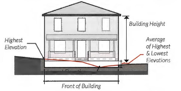
a. For sloped sites, average grade is determined by calculating the average of the highest and lowest elevation along natural or the improved grade (whichever is more restrictive) along the front of the building parallel to the primary street setback line.
b. Where a lot slopes downward from the front property line, one story that is additional to the specified maximum number of stories may be built on the lower rear portion of the lot.

(5) Maximum residential units per acre:
Maximum Building Height and Use | Maximum Units Per Acre |
3 stories, single use | 40 units/acre |
4 stories, single use with height bonus (structured parking or open space) | 60 units/acre |
(6) Height bonus options. A height bonus is applicable for multifamily buildings with eight units or more. Only one height bonus can be utilized in the UR District and shall not allow for heights beyond a four-story maximum. When adjacent to a one-or-two family district, all height bonuses must adhere to the transitional height plane requirements, see subsection (f)(1)c.
a. Structured parking. The intent of allowing a height bonus for structure parking is to locate and design surface parking lots, individual garages, and large parking garages so as to reduce their visual impact or to create public amenities or both (e.g. through aesthetic or environmental features).
1. One additional story of height shall be permitted if providing structured parking for 100% of all off-street parking for the height bonus.
2. One-and-two family residential garages shall not be included in a determination of the applicability of the structured parking height bonus.
b. Open space. One additional story of height shall be permitted if providing a publicly accessible pocket park that adheres to the following standards.
Note: Utilizing the open space height bonus does not exempt a development from applicable park dedication fees.
1. Use criteria.
(i) Pocket parks must provide a community benefit such as: play activity for children, relaxing spaces to enjoy lunch or meet friends, interactive artwork, pet-friendly areas, or small event and garden space.
2. Location.
(i) Pocket parks must front public streets and be publicly accessible.
Note: Refer to subsection (h)(5), Development Standards Applicable to Privately Owned Streets and Drives with Public Access Easements.

3. Size.
(i) Two thousand five hundred (2,500) square feet minimum.
(ii) One (1) acre maximum.
4. Green space.
(i) Pocket parks shall provide a minimum of 20% ground level green space. Additional ground area may be impervious provided the space is structured for recreation, including but not limited to, sculpture gardens, basketball courts, or tennis courts.
(ii) All pocket parks require tree planting. Tree planting requirement may be waived for areas that are designed for structured active recreation.
5. Seating.
(i) A minimum of one linear foot of seating shall be required for every 300 square feet of gross open space.
6. Fencing.
(i) Pocket parks may be fenced but shall conform to subsection (h)(2) and shall remain open to the public during daylight hours.
7. Maintenanc e.
(i) Pocket parks that are privately owned and maintained must be publicly accessible; or
(ii) Must be dedicated in perpetuity as public open space through the recording of a public use easement and have an established long-term maintenance agreement with the park and recreational department.


(e) Off-street parking and loading.
(1) Off-street parking and loading. The following table establishes the required parking for the allowed building types in the UR District. All applicable requirements and applicable nonresidential use requirements included in Chapter 6, Article 2 shall apply.
Building Type/Use | Requirement | Proximity to Rail Station If the development is within 1,320 feet of a rail transit station: |
Single family detached | 2 spaces per dwelling unit. See subsection (e)(3) for location requirements. | No reduction |
Townhouse | 2 spaces per dwelling unit. See subsection (e)(4) for location requirements. | 1 space per dwelling unit. See subsection (e)(4) for location requirements. |
Duplex & manor house (2+ units) | 2 spaces per dwelling unit; Plus, 1 space per bedroom over three bedrooms per dwelling unit. See subsection (e)(3) for location requirements for duplexes. | 1 space per dwelling unit; Plus, 1 space per bedroom over three bedrooms per dwelling unit. See subsection (e)(3) for location requirements for duplexes. |
Apartments/ condominiu ms | 1 space required per bedroom; Plus, 2 spaces per 500 square feet of leasing office and/or social rooms. | 0.5 spaces required per bedroom; Plus, 2 spaces per 500 square feet of leasing office and/or social rooms. |
*All partial spaces are rounded up | ||


(2) Other off-street parking and loading standards.
a. Surface parking shall not be permitted between a building front and the street, provided however, angled, perpendicular, or parallel parking that is designed to function as on-street parking shall be permitted if it meets the following three conditions:
1. The city's traffic engineer determines that the parking does not adversely affect public safety or circulation and satisfies the conditions described in § 22-175d of the City Code.
2. Each parking space is located adjacent to and is directly accessible from a public street or publicly accessible private street; and
3. Surface parking permitted between a building front and the street (on-street parking) and the required pedestrian walkway shall be either dedicated as public right-of-way or be included in a public access easement recorded in the real property records of the county. The front yard setback shall be measured from the curb instead of the property line, and the setback shall be no greater than 20 feet.
b. The required off-street parking for any use may be located off-site, on property within 500 feet of the subject site.
c. Adjacent on-street parking along the lot frontage may be applied toward the minimum parking requirements only when located fully out of the travel lanes.
d. Uses located in historically significant buildings shall be exempt from off-street parking requirements pursuant to Section 6.201(b)(3). For the purpose of this exemption, historically significant buildings shall include those determined by the Historic Preservation Officer to be eligible, based on the applicable criteria, for:
1. Listing in the National Register of Historic Places; or
2. Local designation as either Historic and Cultural Landmark ("HC") or Highly Significant Endangered ("HSE").
(3) Parking location for one-family detached and two-family dwellings.
a. All parking shall be located behind the front building line.
b. Garage doors that face the street must be located a minimum of 20 feet behind any front wall plane of a structure facing a publicly accessible ROW.

(4) Parking location for one-family attached (townhouse, rowhouse).
a. Garages must be placed entirely to the rear of the primary structure and accessed through the use of a rear driveway or alley.
b. Garage doors must face the rear driveway or alley.

(f) Buffers, landscaping, and pedestrian lighting.
(1) Bufferyard and supplemental building setback.
a. A bufferyard is not required between the boundary of a one-or-two family development within the UR District and an adjacent one-or-two family district.

b. Multi-family development adjacent to a one- or two-family district shall have a five foot bufferyard. See § 6.300(d) through (i) for bufferyard requirements.
c. All uses adjacent to a one- or two-family district must apply a transitional height plane of 45 degrees to portions of a building above three stories or 38 feet whichever is less, as measured from the property line of the one- or two-family district.
1. Any portion of a building above three stories must be set back so that the building does not encroach beyond the transitional height plane.
2. These supplemental building setbacks and transitional height plane requirements shall not apply to buildings adjacent to one-or two-family districts that serve as public open space, such as parks and drainage ways.

(2) Enhanced landscaping and pedestrian lighting. Street trees and pedestrian-scaled lighting are required along all public rights-of-way in the UR district, see subsection (h)(5). Adherence to the landscape ordinance, § 6.301 is encouraged, except as here-in provided.
a. The Director or their designee may administratively approve any modifications to streetscape requirements caused by mature trees, utility conflicts, fire hydrants, shallow underground utilities, curb cuts or any other obvious impediment which would prevent the planting of a tree.
b. Street trees.
1. Trees must be planted within a planting strip or flush with the sidewalk surface using tree grates as follows:
(i) Tree grates must be adjustable to allow for tree growth and securely attached. Inner rings must be easily removed with an Allen wrench.
(ii) Tree grate openings shall not exceed 3/8 of an inch.
2. Exceptions.
(i) In the event that infrastructure prevents the use of at-grade planting, a raised planter or crushed stone may be used if approved by the Director or designee.
(ii) Other techniques to provide the street trees will be considered on a case-by-case basis and may be approved by the Director or their designee, or the Director or designee may send the matter to the Urban Design Commission for consideration and decision.
3. Spacing.
Canopy Size | Spacing (on center) |
Small/medium canopy | 25 - 30 ft. |
Large canopy | 35 - 40 ft. |
4. If there are no street trees existing on the project's block face, then spacing is measured from the end of the block beginning 40 feet from the curb intersection to accommodate public open space easement requirements.
c. Pedestrian-scaled lighting.
1. New public and private development must provide pedestrian lights within the roadside's street tree/furniture zone.


2. Required spacing. Pedestrian lights must be located approximately at the midpoint between two trees and spaced a maximum of 60 feet apart.
3. Pedestrian-scaled lighting style must be approved by the Transportation and Public Works Department (TPW) and be consistent with other pedestrian lights on the same block.
4. If there are no pedestrian lights existing on the project's block face, then the spacing is measured from the end of the block. If pedestrian-scaled lights exist, then the spacing is measured from existing lights.
d. Section 6.301(h) "Landscape Area Required" does not apply to developments in the UR District provided; however, the following are applicable in UR:
1. Section 6.301.H.l.b;
2. Section 6.301.H.l.d;
3. When there is a front yard setback of at least five feet, front yard landscaping is required for areas outside the ground level patios, parkways, and pedestrian walkways. Front yard landscaping must adhere to the shrub and native plants as listed in Table A of § 6.301(h), as well as other applicable regulations described or referenced within the UR regulations.
e. Irrigation. An irrigation system must be installed to provide total water coverage to all plant materials installed pursuant to § 6.301
(i) Irrigation.
(3) Landscaping in parking and driveway areas.
Intent: The UR district is intended to create a public environment in which pedestrian safety, comfort, and interest are paramount. Therefore, parking areas that front public streets and pedestrian pathways must be screened to minimize pedestrians' view of parked vehicles and the impact of vehicle headlights.
a. Parking lots and driveways that are located adjacent and parallel to a public street must be screened from the public right-of-way with landscaping, fences, or walls a minimum of three feet in height measured from parking lot grade to a maximum of four feet in height.
b. Landscape islands, linear landscaping strips, bio-swales, or rain gardens shall be required in parking lots with 12 or more spaces. All landscape islands and strips must have at least one tree.

c. Every parking space is required to be not more than 60 feet from a large canopy tree or 40 feet from a medium canopy tree, planted within a median, strip or island, measured from the trunk at planting.


d. Required size of landscape islands and linear landscaping strips containing trees:
1. Within parking lots with non-porous surfaces: 130 square feet; eight feet minimum width.
2. Planted in structured soil: 64 square feet; eight feet minimum width. The use of approved structural soil shall be limited to landscape islands and adjacent walkways and parking area necessary for proper tree growth. Structural soils must not be used for fire lanes in parking lots.
3. Within parking lots with approved porous surfaces for parking areas excluding fire lanes: 16 square feet. Tree trunks should be protected by wheel stops or other physical barriers excluding curbs.
4. Linear landscaping strips are encouraged in lieu of landscaping islands where possible.
(4) Urban forestry.
a. Five percent (5%) site canopy coverage must be provided through either preservation or planting.
b. Developments with surface parking lots must provide 40% canopy coverage over new, expanded, or reconstructed surface parking. The surface parking canopy coverage counts towards the site canopy coverage requirement.
c. Submission of applicable urban forestry plans for review shall follow § 6.302(g), Urban Forestry Plan/Permits.
(g) Facade design standards.
(1) Parking structure facades.
a. Facade design. All parking structure facades that face a public space must be designed to incorporate architectural elements and materials that complement the adjacent building or buildings in the area.
b. Ground level screening. Screening must be incorporated to minimize the visual impact of garages and parked cars at the pedestrian level. Landscaping (including trees and shrubs) may be utilized for screening purposes but must screen at least 50% of pedestrian level parking garage facades immediately upon installation, with species selected to eventually provide full 100% screening.


c. Parking structure openings shall not exceed 20 feet per entrance.
1. For multifamily buildings less than 150 feet in width, the parking structure opening, the parking structure, or both combined, shall not exceed 50% of the ground floor street facade, with the remaining facade for habitable space.
2. For multifamily buildings 150 feet or more in width, the parking structure opening, the parking structure, or both combined, shall not exceed 25% of ground floor street facade, with the remaining facade for habitable space.

d. The property owner is responsible for maintaining all required landscaping in good health and condition and the removal of any litter that has accumulated in landscaped areas. Any dead, unhealthy, damaged or missing landscaping and screening must be replaced with landscaping and screening that conforms to this subsection within 90 days (or within 180 days where seasonal concerns would jeopardize the health of plant materials).
(2) Facade variation.
a. Each new building facade that is greater than 50 feet in width and is oriented to a publicly accessible street or open space must incorporate each of the following scaling elements. For building facades less than 50 feet in width, a minimum of two elements are required.
1. Expression of building structural elements such as:
(i) Floors (banding, belt courses, etc. not less than one inch deep and four inches wide).
(ii) Columns (pilasters, piers, quoins, etc. not less than one inch deep and six inches wide).
(iii) Foundation (water tables, rustication).
2. At least two variation in wall plane not less than three feet in depth or projection and not less than two stories in height for multi-story buildings. Such elements could include patterns of door and window openings by utilizing sills, mullions, and other scale providing window elements, and/or more pronounced architectural features such as porches, alcoves, and roof dormers;

3. Changes in material, material pattern, or noticeable change in color or shade. Each change of material shall involve a minimum one-inch variation in wall plane or noticeable change in color.
b. New building facades oriented to a publicly accessible street or open space must include differentiation between the first and the upper levels with a canopy, balcony, arcade, or other architectural features.
c. If a project consists of more than one block face, each sequential block of new construction must contain a different building facade to encourage architectural variety within large projects, using the required architectural elements listed in subsection (g)(2)a above and/or other architectural features.


(3) Building materials. Not less than 70% of all new building facades (not including door and window areas) facing publicly accessible streets or open space shall be constructed of the following masonry materials:
a. Stone.
b. Brick.
c. Terra cotta.
d. Patterned pre-cast concrete.
e. Cement plaster stucco.
f. Cement board siding.
g. Cast stone or prefabricated brick panels.
(4) Building entries.
Intent: The intent of building entries is to create a pedestrian-oriented development in which buildings are oriented towards publicly accessible streets and sidewalks.
a. The principle building must have its main entrance from a public sidewalk or plaza, or from a private sidewalk or plaza that is publicly accessible through a public use easement.
b. Primary entrances must not be from a parking lot.
c. Secondary entrances from parking lots are permitted.
d. All building entrances for primary entrances for residential units must incorporate arcades, roofs, porches, alcoves, or awnings that protect pedestrians from the sun and rain.
e. Residential entries.
1. Apartments, condominiums, and manor houses with street level units must provide individual street-oriented entries for each unit along the primary street frontage.

Example:
Facade total: 200 x 20 = 4,000 sf.
A Door and window area: 500 sf.
Required masonry: 4,000 - 500 x .70 = 2,450 sf.
B Approved masonry material: 2,450 sf.
C Non-approved masonry material: 1,550 sf.


2. Apartments and condominiu ms must provide primary entrances at intervals not to exceed 125 linear feet of street-oriented building frontage. Entrance spacing is measured from the edge of door to the edge of the next door.
3. Townhouses must have individual street- oriented entries for each unit.
4. Manor houses must have a single primary entrance.
5. A duplex may have one primary entrance for each unit. Each primary entrance into a duplex must be provided under a shared porch or one of the entrances must be accessed from a side facade of the structure.

(h) Other development standards.
(1) Signs. In addition to the development standards in Chapter 6, Article 4, the following provisions apply:
a. On premise signs on one-family dwellings, manor houses with two dwelling units, and townhouses are limited to one unilluminated nameplate per unit not to exceed one square foot in area.
b. For apartments, condominiums and manor houses containing more than two dwelling units, attached identification signs shall be permitted, subject to the following provisions;
1. Attached signs shall be permitted to identify the name of the property upon which displayed.
2. A sign or combination of signs shall have a maximum allowable area of exposure on each dedicated street frontage of not more than one square foot of sign area for each ten linear feet of frontage along said street; provided, however, at least one sign shall be allowed having an area of 12 square feet.
3. Signs may not be illuminated.
c. An illuminated sign for those uses permitted that are not residential is not allowed. The sign shall not exceed 30 square feet in area, shall be no higher than six feet above grade, and shall be placed a minimum of ten feet behind the property line. Such sign shall not be placed within 20 feet of drives providing ingress and egress to the property.
(2) Fences, gates, and walls.
a. Complexes with perimeter security fencing along public streets are prohibited.
b. Fences shall not be located in the area between the front building facade and the public street frontage or public open spaces.
c. Exterior fences and gates that are located along public streets, along private streets or walkways that are publicly accessible through a public use easement, or along publicly accessible open space shall not extend beyond building facades.
d. All fences and walls along public street frontage or public open spaces that are taller than 4 feet must be open design.
e. All fences and railings must be architecturally compatible with the character of the building and be constructed of high-quality materials including: wrought iron, composite fencing, treated wood, aluminum, or metal. Chain link, barbed wire, and concertina wire material is prohibited.


f. All walls must be architecturally compatible with the character of the building and constructed of high- quality materials including stone, decorative blocks, brick, cast stone, or stucco over standard concrete masonry blocks.
g. For private residential patios and yards, a front yard fence, railing, or low wall may extend beyond the building facade if the following requirements are met:
1. Fences, railings, and walls must not exceed four feet (48") in total height as measured from the ground to the top of the fence, railing, and/or the wall however;
2. For elevated residential stoops the total fence, railing and/or wall height must not exceed five feet (60") total.


(3) Service areas screening.
a. Trash and recycling collection, and other similar service areas, must be located to the side or rear of buildings and behind the primary structures on street frontages.
b. All refuse and recycling collection containers for apartments/condominiums must be located on a concrete pad and shall be screened on three sides by an opaque fence or wall. The fourth side must be an opaque gate.
c. The design, colors, and materials of screening elements shall be architecturally compatible with the character of the building.

(4) Mechanical equipment screening.
Alternative | Fully Screen from Public Right-of-Way (Alleys excluded) | Permitted Screening Materials | ||
Landscaping | Opaque Wall/Fence | Architectural Screening Elements | ||
Wall-mounted | • | • | •2 | |
Roof-mounted | •1 | • | ||
Ground-mounted | • | • | •2 | |
1 Must be screened from abutting properties and the public street. 2 If an opaque wall or fence is provided, it shall be compatible with the principal building in terms of texture, quality, material, and color. | ||||


(5) Privately owned streets and drives with public access easements. Private streets and drives with public access easements shall be considered public streets or right-of- way for the purpose of review for compliance with setbacks, pocket parks, parking, screening, enhanced landscaping, facade variations, fenestration, and other UR design requirements normally based on street.
(Ord. 20159-04-2012, § 1 (Exh. A), passed 4-3-2012; Ord. 22809-08-2017, § 1 (Exh. A), passed 8-1- 2017, eff. 9-7-2017; Ord. 23309-08-2018, §§ 1–2, passed 8-7-2018; Ord. 24030-02-2020, § 22, passed 2-4-2020; Ord. 25190-11-2021, § 1, passed 11-9-2021, eff. 12-16-2021)
(a) Permitted uses (P). A “P” in a cell indicates that a use is allowed by right in the respective zoning district. Permitted uses are subject to all other applicable regulations of this zoning ordinance. A “P*” in any cell means that supplemental use standards apply. (Refer to Supplemental Use Standards, Chapter 5, Article 1, Standards for Selected Uses.) The specific section number of the standard is noted in the right-hand column, titled “Supplemental Standards.”
(b) Special exception uses (SE). An “SE” in a cell indicates that a use is allowed only if reviewed and approved as a special exception use, in accordance with the review procedures of Chapter 3, Article 3. An “SE*” in any cell means that supplemental use standards apply. (Refer to Supplemental Use Standards, Chapter 5, Article 1, Standards for Selected Uses.) The specific section number of the standard is noted in the right-hand column, titled “Supplemental Standards.”
(c) Conditional use permit (CUP). A "CUP" in a cell indicates that the use is allowed only if reviewed and approved as a conditional use permit, in accordance with the review procedures in Chapter 4, Article 4. A CUP* in any cell means that supplemental use standards apply.
(d) Uses not allowed. An empty cell indicates that a use is not allowed in the respective zoning district. Provided however, an application for a conditional use permit may be made for any land use not permitted in any district in accordance with the review procedures in Chapter 4, Article 4.
(e) Supplemental use standards (*). The numbers contained in the right-hand column of the table are references to additional standards and requirements (refer to Supplemental Use Standards, Chapter 5, Article 1, Standards for Selected Uses) that may apply to the use listed. Standards referenced in this column apply only in zoning districts where the designation includes a “*.”
(f) Use also included on residential district use table (<<). The “<<“ symbol in the second column from the right indicates this use can also be found in the Residential District Use Table in Article 6.
(Ord. 20159-04-2012, § 1 (Exh. A), passed 4-3-2012; Ord. 23609-03-2019, § 3, passed 3-19-2019)
Additional uses have been interpreted as part of or similar to many of the uses listed in the table. The full list of such uses is included in Appendix C, Use Index. If a use is not listed, then the zoning administrative official shall, upon request of any interested party, make a determination within which district, if any, a proposed use should be allowed.
(Ord. 20159-04-2012, § 1 (Exh. A), passed 4-3-2012; Ord. 23110-02-2018, § 5, passed 2-6-2018)
Loading...