SECTION:
21A.26.010: General Provisions
21A.26.020: CN Neighborhood Commercial District
21A.26.025: SNB Small Neighborhood Business District
21A.26.030: CB Community Business District
21A.26.040: CS Community Shopping District
21A.26.050: CC Corridor Commercial District
21A.26.060: CSHBD Sugar House Business District (CSHBD1 And CSHBD2)
21A.26.070: CG General Commercial District
21A.26.077: TC-75 Transit Corridor District (Rep. by Ord. 46-17, 2017)
21A.26.078: TSA Transit Station Area District
A. Statement Of Intent: Salt Lake City commercial districts are intended to enhance the economic vitality of the specific commercial districts and the City as a whole, encourage sustainable and profitable businesses, create dynamic and vital business districts, and implement the adopted development policies of the City. The zoning districts differ in the range and intensity of uses to reflect the diverse nature of the commercial areas within the City. Some zoning districts encourage commercial development that supports residential neighborhoods while other zoning districts promote community and regional commercial areas. Each zoning district includes standards and land uses that are intended to provide certainty to property owners, business owners and neighbors about what is allowed and to enhance employment opportunities, encourage efficient use of land and to enhance property values and the tax base. The standards are intended to allow development flexibility within parameters that support the purpose statement of the individual zoning districts and promote the desired character for the commercial area.
B. Site Plan Review: In certain districts, permitted uses and conditional uses have the potential for adverse impacts if located and laid out without careful planning. Such impacts may interfere with the use and enjoyment of adjacent property and uses. Site plan review is a process designed to address such adverse impacts and minimize them where possible. Site plan review is required for all conditional uses, and all permitted uses except single-family dwellings, two-family dwellings and twin homes. All uses in these districts shall be subject to the site plan review regulations contained in chapter 21A.58 of this title.
C. Impact Controls and General Restrictions in the Commercial Districts:
1. Refuse Control: Temporary storage of refuse materials shall be limited to that produced on the premises. Refuse containers must be covered and shall be stored within completely enclosed buildings or screened in conformance with the requirements of Section 21A.40.120 of this title. For buildings existing as of April 12, 1995, this screening provision shall be required if the floor area or parking requirements are increased by twenty five percent (25%) or more by an expansion to the building or change in the type of land use.
2. Lighting: On site lighting shall be located, directed or designed in such a manner as to contain and direct light and glare to the property on which it is located only.
3. Outdoor Sales, Display Or Storage: "Sales and display (outdoor)" and "storage and display (outdoor)", as defined in chapter 21A.62 of this title, are allowed where specifically authorized in the table of permitted and conditional uses in section 21A.33.030 of this title. These uses shall also conform to the following:
a. The outdoor sales or display of merchandise shall not encroach into areas of required parking;
b. The outdoor sales or display of merchandise shall not be located in any required yard area within the lot;
c. The outdoor sales or display of merchandise shall not include the use of banners, pennants, or strings of pennants;
d. Outdoor storage shall be required to be fully screened with opaque fencing not to exceed seven feet (7') in height; and
e. Outdoor sales and display and outdoor storage shall also be permitted when part of an authorized temporary use as established in chapter 21A.42 of this title.
D. Permitted Uses: The uses specified as permitted uses in section 21A.33.030, "Table Of Permitted And Conditional Uses For Commercial Districts", of this title are permitted provided that they comply with all requirements of this chapter, the general standards set forth in part IV of this title, and all other applicable requirements of this title.
E. Conditional Uses: The uses specified as conditional uses in section 21A.33.030, "Table Of Permitted And Conditional Uses For Commercial Districts", of this title shall be allowed in the Commercial Districts provided they are approved pursuant to the standards and procedures for conditional uses set forth in chapter 21A.54 of this title, and comply with all other applicable requirements of this title.
F. Accessory Uses, Buildings And Structures: Accessory uses and structures are permitted in the Commercial Districts subject to the requirements of this chapter, subsection 21A.36.020B, section 21A.36.030, and chapter 21A.40 of this title.
G. Off Street Parking And Loading: The parking and loading requirements for the Commercial Districts are set forth in chapter 21A.44 of this title.
H. Landscaping and Buffering: The landscaping and buffering requirements for the commercial districts shall be as specified in Chapter 21A.48 of this title.
I. Signs: Signs shall be allowed in the Commercial Districts in accordance with provisions of chapter 21A.46 of this title.
J. Modifications to Maximum Height: The maximum height of buildings in commercial zoning districts may be increased up to ten percent (10%) on any building face due to the natural topography of the site pursuant to the following standards:
1. At least fifty percent (50%) of the building complies with the maximum height of the underlying zoning district;
2. The modification allows the upper floor of a building to be level with the portion of the building that complies with the maximum building height of the zone without the ten percent (10%) modification; and
3. The height of the ground floor is at least twelve (12) feet in height measured from finished floor to finished ceiling height. (Ord. 56-24, 2024: Ord. 12-24, 2024: Ord. 64-21, 2021: Ord. 14-19, 2019: Ord. 66-13, 2013: Ord. 15-13, 2013: Ord. 73-11, 2011: Ord. 12-11, 2011: Ord. 35-99 §§ 22, 23, 1999: Ord. 88-95 (Exh. A), 1995: Ord. 26-95 § 2(13-0), 1995)
A. Purpose Statement: The CN Neighborhood Commercial District is intended to provide for small scale, low intensity commercial uses that can be located within and serve residential neighborhoods. This district is appropriate in areas where supported by applicable master plans and along local streets that are served by multiple transportation modes, such as pedestrian, bicycle, transit and automobiles. The standards for the district are intended to reinforce the historic scale and ambiance of traditional neighborhood retail that is oriented toward the pedestrian while ensuring adequate transit and automobile access. Uses are restricted in size to promote local orientation and to limit adverse impacts on nearby residential areas.
B. Uses: Uses in the CN Neighborhood Commercial District as specified in section 21A.33.030, "Table Of Permitted And Conditional Uses For Commercial Districts", of this title, are permitted subject to the general provisions set forth in section 21A.26.010 of this chapter and this section.
C. Planned Development Review: Planned developments, which meet the intent of the ordinance, but not the specific design criteria outlined in the following subsections, may be approved by the Planning Commission pursuant to the provisions of chapter 21A.55 of this title.
D. Lot Size Requirements: No minimum lot area or lot width is required. No lot shall be larger than sixteen thousand five hundred (16,500) square feet.
E. Maximum District Size: The total area of a contiguously mapped CN District shall not exceed ninety thousand (90,000) square feet, excluding all land in public rights-of-way.
F. Minimum Yard Requirements:
1. Front or Corner Side Yard: A fifteen foot (15') minimum front or corner side yard shall be required. Exceptions to this requirement may be authorized as design review, subject to the requirements of Chapter 21A.59 of this title, and the review and approval of the planning commission.
2. Interior Side Yard: None required.
3. Rear Yard: Ten feet (10').
4. Landscape Buffer Yards: Any lot abutting a lot in a Residential District shall conform to the landscape buffer yard requirements of Chapter 21A.48, "Landscaping and Buffers", of this title.
5. Accessory Buildings and Structures in Yards: Accessory buildings and structures may be located in a required yard subject to Section 21A.36.020, Table 21A.36.020.B of this title.
6. Maximum Setback: A maximum setback is required for at least sixty five percent (65%) of the building facade. The maximum setback is twenty five feet (25'). Exceptions to this requirement may be authorized through the design review process, subject to the requirements of Chapter 21A.59 of this title, and the review and approval of the planning commission. The planning director, in consultation with the transportation director, may modify this requirement if the adjacent public sidewalk is substandard and the resulting modification to the setback results in a more efficient public sidewalk. The planning director may waive this requirement for any addition, expansion, or intensification, which increases the floor area or parking requirement by less than fifty percent (50%) if the planning director finds the following:
a. The architecture of the addition is compatible with the architecture of the original structure or the surrounding architecture.
b. The addition is not part of a series of incremental additions intended to subvert the intent of the ordinance.
Appeal of administrative decision is to the planning commission.
G. Landscape Yard Requirements: Front and corner side yards shall be maintained as landscape yards, conforming to the requirements of Chapter 21A.48. Subject to site plan review approval, part or all of the landscape yard may be a patio or plaza.
H. Maximum Height: Twenty five feet (25'). (Ord. 12-24, 2024: Ord. 10-24, 2024: Ord. 67-22, 2022: Ord. 14-19, 2019: Ord. 12-17, 2017)
A. Purpose Statement: The purpose of the Small Neighborhood Business Zoning District is to provide areas for small commercial uses to be located adjacent to residential land uses, including mid block. This district will preserve and enhance older commercial structures and storefront character by allowing a variety of commercial uses and placing more strict regulations on new construction and major additions to existing buildings. The regulations are intended to restrict the size and scale of the commercial uses in order to mitigate negative impacts to adjacent residential development and encourage pedestrian oriented development. This zoning district is appropriate in places where it is supported by a community master plan, small area master plan or other adopted City policies.
B. Uses: Uses in the SNB Small Neighborhood Business District are as specified in the table of permitted and conditional uses set forth in chapter 21A.33 of this title.
C. Design Review:
1. Projects which meet the intent of this section, but not the specific design criteria outlined in the following subsections, may be approved by the Planning Commission pursuant to the provisions of chapter 21A.59 of this title.
D. Minimum Lot Area And Lot Width: The minimum lot areas and lot widths required in this district are as follows:
Land Use | Minimum Lot Area | Minimum Lot Width |
Land Use | Minimum Lot Area | Minimum Lot Width |
Dwelling unit, located above first floor retail or office uses | Included in principal use | Included in principal use |
Municipal service uses, including City utility uses and police and fire stations | No minimum | No minimum |
Natural open space and conservation areas, public and private | No minimum | No minimum |
Places of worship less than 4 acres in size | 5,000 square feet | 50 feet |
Public pedestrian pathways, trails and greenways | No minimum | No minimum |
Public/private utility transmission wires, lines, pipes and poles | No minimum | No minimum |
Retail goods establishments, when located within an existing building originally designed for residential use | 5,000 square feet | 50 feet |
Retail service establishments, when located within an existing building originally designed for residential use | 5,000 square feet | 50 feet |
Single-family detached dwellings | 5,000 square feet | 50 feet |
Two-family dwellings | 8,000 square feet | 50 feet |
Other permitted or conditional uses as listed in section 21A.33.030 of this title | 5,000 square feet | 50 feet |
E. Maximum District Size:
1. Sixteen thousand (16,000) square feet.
F. Yard Requirements:
1. Front and Corner Side Yard: Front and corner side yard setbacks shall be equal to the required yard areas of the abutting zoning district along the block face. When the property abuts more than one zone the more restrictive requirement shall apply.
2. Interior Side Yard: Interior side yard equal to the required yard areas of the abutting zoning district along the block face. When the property abuts more than one zone the more restrictive requirement shall apply.
3. Rear Yard: Rear yard setbacks shall be equal to the required yard areas of the abutting zoning district along the block face. When the property abuts more than one zoning district the more restrictive requirement shall apply.
4. Landscape Buffer Yards: Any lot abutting a lot in a Residential District shall conform to the landscape buffer yard requirements of Chapter 21A.48, "Landscaping and Buffers", of this title.
5. Accessory Buildings and Structures in Yards: Accessory buildings and structures may be located in a required yard subject to Section 21A.36.020, Table 21A.36.020.B, "Obstructions in Required Yards", of this title.
G. Landscape Yard Requirements:
1. Front and corner side yards shall be maintained as landscape yards. Subject to site plan review approval, part or the entire landscape yard may be a patio or plaza.
H. Maximum Height:
1. Twenty five feet (25'). However, in no instance shall the height exceed the maximum height of any abutting Residential Zoning District along the block face.
I. Maximum Height Of Accessory Structures:
1. Refer to subsection 21A.40.050C of this title.
J. Hours Of Operation:
1. Businesses in the SNB Zone shall be open to the general public no earlier than seven o'clock (7:00) A.M. and no later than ten o'clock (10:00) P.M.
K. New Nonresidential Construction:
1. Construction of a new principal building, parking lot or addition to an existing building for a nonresidential use that includes the demolition of a commercial structure or a structure containing residential units may only be approved through a design review process pursuant to chapter 21A.59 of this title and provided, that in such cases the Planning Commission finds that the applicant has adequately demonstrated the following:
a. The replacement use for properties containing residential units will include an equal or greater number of residential units; and
b. The structure is isolated from other structures and does not relate to other structures within the residential-business neighborhood. For purpose of this section, an isolated structure is a structure that does not meet the development pattern of the block face or block faces for corner properties; and
c. The design and condition of the structure is such that it does not make a material contribution to the character of the neighborhood. A structure is considered to make a material contribution when it is similar in scale, height, width, and solid to void ratio of openings in the principal street facing facade.
L. Enlargement Of A Structure: The enlargement by square footage of an existing structure may be approved by an Administrative Hearing Officer only if all of the following conditions are met:
1. Use is permitted in the zone.
2. The proposed use is compatible to the neighborhood in terms of development intensity, building configuration, building height, and building bulk.
3. The traffic generated by the proposed expansion is similar to that generated by the existing use or off street parking is available for the additional square footage.
4. The use will not be detrimental to the existing character of development in the immediate neighborhood or endanger the public health, safety, or general welfare. (Ord. 12-24, 2024: Ord. 10-24, 2024: Ord. 67-22, 2022: Ord. 14-19, 2019: Ord. 12-17, 2017)
A. Purpose Statement: The CB Community Business District is intended to provide for the close integration of moderately sized commercial areas with adjacent residential neighborhoods. The design guidelines are intended to facilitate retail that is pedestrian in its orientation and scale, while also acknowledging the importance of transit and automobile access to the site.
B. Uses: Uses in the CB Community Business District as specified in section 21A.33.030, "Table Of Permitted And Conditional Uses For Commercial Districts", of this title are permitted subject to the general provisions set forth in section 21A.26.010 of this chapter and this section.
C. Planned Development Review: Planned developments, which meet the intent of the ordinance, but not the specific design criteria outlined in the following subsections, may be approved by the Planning Commission pursuant to the provisions of chapter 21A.55 of this title.
D. Lot Size Requirements: No minimum lot area or lot width is required, however any lot exceeding four (4) acres in size shall be allowed only through the design review process (chapter 21A.59 of this title).
E. Building Size Limits: Buildings in excess of seven thousand five hundred (7,500) gross square feet of floor area for a first floor footprint or in excess of fifteen thousand (15,000) gross square feet floor area overall, shall be allowed only through the design review process (chapter 21A.59 of this title). An unfinished basement used only for storage or parking shall be allowed in addition to the total square footage. In addition to the design review standards in chapter 21A.59 of this title, the Planning Commission shall also consider the following standards:
1. Compatibility: The proposed height and width of new buildings and additions shall be visually compatible with buildings found on the block face.
2. Roofline: The roof shape of a new building or addition shall be similar to roof shapes found on the block face.
3. Vehicular Access: New buildings and additions shall provide a continuous street wall of buildings with minimal breaks for vehicular access.
4. Facade Design: Facade treatments should be used to break up the mass of larger buildings so they appear to be multiple, smaller scale buildings. Varied rooflines, varied facade planes, upper story step backs, and lower building heights for portions of buildings next to less intensive zoning districts may be used to reduce the apparent size of the building.
5. Buffers: When located next to low density residential uses, the Planning Commission may require larger setbacks, landscape buffers and/or fencing than what are required by this title if the impacts of the building mass and location of the building on the site create noise, light trespass or impacts created by parking and service areas.
6. Step Backs: When abutting single-story development and/or a public street, the Planning Commission may require that any story above the ground story be stepped back from the building foundation at grade to address compatibility issues with the other buildings on the block face and/or uses.
F. Minimum Yard Requirements:
1. Front or Corner Side Yard: No minimum yard is required. If a front yard is provided, it shall comply with all provisions of this title applicable to front or corner side yards, including landscaping, fencing, and obstructions.
2. Interior Side Yard: None required.
3. Rear Yard: Ten feet (10').
4. Landscape Buffer Yards: Any lot abutting a lot in a Residential District shall conform to the landscape buffer yard requirements of Chapter 21A.48, "Landscaping and Buffers", of this title.
5. Accessory Buildings and Structures in Yards: Accessory buildings and structures may be located in a required yard subject to Section 21A.36.020, Table 21A.36.020B of this title.
6. Maximum Setback: A maximum setback is required for at least seventy five percent (75%) of the building facade. The maximum setback is fifteen feet (15'). Exceptions to this requirement may be authorized through the design review process, subject to the requirements of Chapter 21A.59 of this title, and the review and approval of the planning commission. The planning director, in consultation with the transportation director, may modify this requirement if the adjacent public sidewalk is substandard and the resulting modification to the setback results in a more efficient public sidewalk. The planning director may waive this requirement for any addition, expansion, or intensification, which increases the floor area or parking requirement by less than fifty percent (50%) if the planning director finds the following:
a. The architecture of the addition is compatible with the architecture of the original structure or the surrounding architecture.
b. The addition is not part of a series of incremental additions intended to subvert the intent of the ordinance.
Appeal of administrative decision is to the planning commission.
G. Landscape Yard Requirements: If a front or corner side yard is provided, such yard shall be maintained as a landscape yard. The landscape yard can take the form of a patio or plaza, subject to site plan review approval.
H. Maximum Height: Thirty feet (30'). (Ord. 10-24, 2024: Ord. 67-22, 2022: Ord. 14-19, 2019: Ord. 12-17, 2017)
A. Purpose Statement: The purpose of the CS Community Shopping District is to provide an environment for vibrant, efficient and attractive shopping center development at a community level scale while promoting compatibility with adjacent neighborhoods through design standards. This district provides economic development opportunities through a mix of land uses, including retail sales and services, entertainment, office and residential. This district is appropriate in areas where supported by applicable master plans, along City and State arterial streets and where the mass and scale of development is compatible with adjacent land uses. Development is intended to be oriented toward the pedestrian while accommodating other transportation modes.
B. Uses: Uses in the CS Community Shopping District as specified in section 21A.33.030, "Table Of Permitted And Conditional Uses For Commercial Districts", of this title are permitted subject to the general provisions set forth in section 21A.26.010 of this chapter and this section.
C. Planned Development Review: All new construction of principal buildings, uses, or additions that increases the floor area and/or parking requirement by twenty five percent (25%) in the CS Community Shopping District may be approved only as a planned development in conformance with the provisions of chapter 21A.55 of this title.
D. Minimum Lot Size:
1. Minimum lot area: Sixty thousand (60,000) square feet, excluding shopping center pad sites.
2. Minimum lot width: One hundred fifty feet (150').
E. Minimum Yard Requirements:
1. Front And Corner Side Yard: Thirty feet (30').
2. Interior Side Yard: Fifteen feet (15').
3. Rear Yard: Thirty feet (30').
4. Landscape Buffer Yards: Any lot abutting a lot in a Residential District shall conform to the landscape buffer yard requirements of Chapter 21A.48, "Landscaping and Buffers", of this title.
5. Accessory Buildings And Structures In Yards: Accessory buildings and structures may be located in a required yard subject to section 21A.36.020, table 21A.36.020B of this title.
F. Landscape Yard Requirements: A landscape yard of fifteen feet (15') shall be required on all front and corner side yards, conforming to the requirements of Chapter 21A.48.
G. Maximum Height: No building shall exceed forty five feet (45').
H. Access Restrictions: To maintain safe traffic conditions, lots in the CS Community Shopping District shall not exceed one driveway per one hundred fifty feet (150') of frontage on arterial or major collector streets. The location of driveways shall be subject to review by the development review team through the site plan review process.
I. Effect Of Planned Development On Minimum Standards: Pursuant to chapter 21A.55 of this title, the Planning Commission may modify the standards set forth in subsections D through H of this section in the approval of planned developments within this district. (Ord. 12-24, 2024: Ord. 10-24, 2024: Ord. 66-13, 2013: Ord. 12-11, 2011: Ord. 23-10 § 6, 2010: Ord. 61-09 § 16, 2009: Ord. 35-99 § 24, 1999: Ord. 88-95 § 1 (Exh. A), 1995: Ord. 26-95 § 2(13-3), 1995)
A. Purpose Statement: The purpose of the CC Corridor Commercial District is to provide an environment for efficient and attractive commercial development with a local and regional market area along arterial and major collector streets while promoting compatibility with adjacent neighborhoods through design standards. This district provides economic development opportunities through a mix of land uses, including retail sales and services, entertainment, office and residential. Safe, convenient and inviting connections that provide access to businesses from public sidewalks, bike paths and streets are necessary. Access should follow a hierarchy that places the pedestrian first, bicycle second and automobile third. This district is appropriate in areas where supported by applicable master plans. The standards are intended to promote a safe and aesthetically pleasing environment to all users.
B. Uses: Uses in the CC Corridor Commercial District as specified in section 21A.33.030, "Table Of Permitted And Conditional Uses For Commercial Districts", of this title, are permitted subject to the general provisions set forth in section 21A.26.010 of this chapter and this section.
C. Minimum Lot Size:
1. Minimum lot area: Ten thousand (10,000) square feet.
2. Minimum lot width: Seventy five feet (75').
D. Minimum Yard Requirements:
1. Front And Corner Side Yards: Fifteen feet (15').
2. Interior Side Yards: None required.
3. Rear Yards: Ten feet (10').
4. Landscape Buffer Yards: Any lot abutting a lot in a Residential District shall conform to the landscape buffer yard requirements of Chapter 21A.48, "Landscaping and Buffers", of this title.
5. Accessory Buildings And Structures In Yards: Accessory buildings and structures may be located in a required yard subject to section 21A.36.020, table 21A.36.020B of this title.
E. Landscape Yard Requirements: A landscape yard of fifteen feet (15') shall be required on all front and corner side yards, conforming to the requirements of Chapter 21A.48.
F. Maximum Height: No building shall exceed thirty feet (30'). Buildings higher than thirty feet (30') may be allowed in accordance with the provisions of subsections F1 and F3 of this section.
1. Procedure For Modification: A modification to the height regulations in this subsection F may be granted through the design review process in conformance with the provisions of chapter 21A.59 of this title. In evaluating an application submitted pursuant to this section, the Planning Commission shall find that the increased height will result in improved site layout and amenities.
2. Landscaping: If an additional floor is approved, increased landscaping shall be provided over and above that which is normally required for landscape yards, landscape buffer yards, and parking lot perimeter and interior landscaping. The amount of increased landscaping shall be equal to ten percent (10%) of the area of the additional floor.
3. Maximum Additional Height: Additional height shall be limited to fifteen feet (15'). (Ord. 12-24, 2024: Ord. 10-24, 2024: Ord. 14-19, 2019: Ord. 66-13, 2013: Ord. 15-13, 2013: Ord. 12-11, 2011: Ord. 61-09 § 17, 2009: Ord. 3-01 § 1, 2001: Ord. 88-95 § 1 (Exh. A), 1995: Ord. 26-95 § 2(13-4), 1995)
In this chapter and the associated zoning map, the CSHBD Zone is divided into two (2) subareas for the purpose of defining design criteria. In other portions of this text, the CSHBD1 and CSHBD2 Zones are jointly referred to as the CSHBD Zone because all other standards in this title are the same.
A. Purpose Statement: The purpose of the CSHBD Sugar House Business District is to promote a walkable community with a transit oriented, mixed use town center that can support a twenty-four (24) hour population. The CSHBD provides for residential, commercial and office use opportunities, with incentives for high density residential land use in a manner compatible with the existing form and function of the Sugar House master plan and the Sugar House Business District.
B. Uses: Uses in the CSHBD Sugar House Business District as specified in Section 21A.33.030, "Table of Permitted and Conditional Uses for Commercial Districts", of this title are permitted, subject to the general provisions set forth in Section 21A.26.010 of this chapter and this section.
C. Design Standards Compliance: Development shall comply with the requirements of Chapter 21A.37 "Design Standards" when applicable as specified in that chapter.
D. Design Review: All new construction of principal buildings that exceed fifty feet (50') in height in the CSHBD1 District or thirty feet (30') in height in the CSHBD2 District or twenty thousand (20,000) gross square feet in size in either district shall be subject to design review. Design review shall be approved in conformance with the "Sugar House Business District Design Guideline Handbook" (located as an appendix section in the Sugar House Master Plan), "Sugar House Circulation and Streetscape Amenities Plan," and the provisions of Chapter 21A.59 of this title.
E. Minimum Lot Size: No minimum lot area or width is required.
F. Minimum Yard Requirements:
1. Front and Corner Side Yards: No minimum yard is required.
2. Maximum Front/Corner Side Yard Setback: The maximum front and corner side yard setback is fifteen feet (15'). Exceptions to this requirement may be authorized through the design review process, subject to the requirements of Chapter 21A.59 of this title, and the review and approval of the planning commission. The planning director, in consultation with the transportation director, may modify this requirement if the adjacent public sidewalk is substandard and the resulting modification to the setback results in a more efficient public sidewalk, and/or the modification conforms with the "Sugar House Business District Design Guidelines Handbook" or "Sugar House Circulation and Streetscape Amenities Plan." Appeal of an administrative decision is to the planning commission.
3. Interior Side Yards: None required.
4. Rear Yards: None required.
5. Landscape Buffer Yards: Any lot abutting a lot in a Residential District shall conform to the landscape buffer yard requirements of Chapter 21A.48, "Landscaping and Buffers", of this title.
6. Setback from Single-Family Zones: For those structures located on properties zoned CSHBD that abut properties in a Low Density, Single-Family Residential Zone, every three feet (3') in building height above thirty feet (30'), shall be required a corresponding one foot (1') setback from the property line at grade. This additional required setback area can be used for landscaping or parking.
7. Parking Setbacks: See Table 21A.44.060 for parking location restrictions.
G. Maximum Height: Maximum height limits vary, depending upon location and land use. The following regulations shall apply for each area within the CSHBD Zone:
1. CSHBD1:
Height Limit | Residential Use | Nonresidential Use |
Up to 30' | Allowed. | Allowed. |
>30' to 75' | Allowed. | For every square foot of nonresidential gross floor area above 30' in height, an equivalent gross floor area of residential use must be provided. The residential floor area may be provided within the same building or in a separate building. Separate building option requires a development agreement with the city specified in Subsection 21A.26.060
.I. |
>75' to 105' | Allowed if 90% of the required parking for the building is within a parking structure. | Compliance with the same standard for >30' to 75'height noted above, and 90% of the required parking for the building must be located within a parking structure. |
2. CSHBD2:
Height Limit | Residential Use | Nonresidential Use |
Up to 30' | Allowed. | Allowed. |
>30' to 60' | Allowed. | For every square foot of nonresidential gross floor area above 30' in height, an equivalent gross floor area of residential use must be provided. The residential floor area may be provided within the same building or in a separate building. Separate building option requires a development agreement with the City specified in Subsection 21A.26.060
.I. If the residential is provided off-site, the nonresidential building is limited to a height of 45'. |
H. First Floor/Street Level Requirements: The ground floor use area required by Chapter 21A.37 shall be occupied by residential, retail goods establishments, retail service establishments, public service portions of businesses, restaurants, taverns/brewpubs, bar establishments, art galleries, theaters or performing art facilities.
For such areas facing 2100 South, 1100 East, or Highland Drive, residential dwelling units are not allowed within the required ground floor use area. Live/work units are allowed in this space if the working area of the unit is located on the ground floor.
I. Residential Requirement for Mixed Use Developments: For those mixed use developments requiring a residential component, the residential portion of the development shall be as follows:
1. Located in the same building as noted in Subsection G of this section, or
2. May be located in a separate building and/or on a different property in the area zoned CSHBD. For such off site residential configuration, the amount of residential development required is equal to the total amount of gross square footage obtained for the nonresidential floors rising in excess of thirty feet (30'). In addition, prior to the issuance of a building permit for the nonresidential structure, the applicant must identify specifically where the residential structure will be located in the area zoned CSHBD and enter into a development agreement with the city to ensure the construction of the residential structure in a timely manner. In such cases where the residential use is built off site, one of the following shall apply:
a. Construction of the off site residential use must be progressing beyond the footings and foundation stage, prior to the nonresidential portion of the development obtaining a certificate of occupancy, or
b. Prior to the nonresidential portion of the development obtaining a certificate of occupancy, a financial assurance shall be provided to the city assuring that construction of the residential use will commence within two (2) years of receiving a certificate of occupancy for the nonresidential component of the development. The financial assurance shall be in an amount equal to fifty percent (50%) of the construction valuation for the residential component of the development as determined by the building official. The city shall call the financial assurance and deposit the proceeds in the city's Housing Trust Fund if construction has not commenced within two (2) years of the issuance of the certificate of occupancy for the nonresidential component of the development.
J. Park Strip Materials: Properties within this zoning district may utilize alternative park strip landscaping materials. Alternative materials are subject to planning director approval based on its compliance with the adopted “Circulation and Streetscape Amenities Plan” or its successor.
K. Street Trees: Street trees are required and subject to the regulations in Chapter 21A.48. If a park strip does not exist, street trees are required when the sidewalk width of at least 10' can be maintained, to which required street trees shall be planted in tree wells with tree grates with sufficient soil volume as determined by the Urban Forestry Division.
L. Street Lighting: Street lighting shall be installed in accordance with the City Street Lighting Master Plan (or its successor) and any other contract or agreement with the city pertaining to street lighting. This requirement only applies to new principal buildings.
M. Sidewalk Materials: Sidewalk paving shall include a minimum of ten percent (10%) brick or pavers as an accent material, subject to engineering division approval. Modifications to this requirement may be approved by the planning director if in compliance with the adopted "Sugar House Circulation and Streetscape Amenities Plan" or its successor. This requirement only applies to new principal buildings.
N. Sidewalk Width: Sidewalks shall be a minimum of ten feet (10') wide. This requirement applies to new principal buildings and to additions that increase the gross building square footage by more than fifty percent (50%). This standard does not require removal of existing street trees, existing buildings, or portions thereof. For purposes of this section, sidewalk width is measured from the back of the park strip or required street tree if no park strip is provided, toward the abutting property line. Modifications to this requirement may be approved by the planning director if in compliance with the adopted "Sugar House Circulation and Streetscape Amenities Plan" or its successor. (Ord. 12-24, 2024: Ord. 10-24, 2024: Ord. 72-21, 2021: Ord. 14-19, 2019: Ord. 23-18, 2018: Ord. 12-17, 2017)
A. Purpose Statement: The purpose of the CG General Commercial District is to provide an environment for a variety of commercial uses, some of which involve the outdoor display/storage of merchandise or materials. This district provides economic development opportunities through a mix of land uses, including retail sales and services, entertainment, office, residential, heavy commercial and low intensities of manufacturing and warehouse uses. This district is appropriate in locations where supported by applicable master plans and along major arterials. Safe, convenient and inviting connections that provide access to businesses from public sidewalks, bike paths and streets are necessary. Access should follow a hierarchy that places the pedestrian first, bicycle second and automobile third. The standards are intended to create a safe and aesthetically pleasing commercial environment for all users.
B. Uses: Uses in the CG General Commercial District as specified in Section 21A.33.030, "Table of Permitted and Conditional Uses for Commercial Districts", of this title are permitted subject to the general provisions set forth in Section 21A.26.010 and this section.
C. Minimum Lot Size:
1. Minimum Lot Area: ten thousand (10,000) square feet.
2. Minimum Lot Width: sixty feet (60').
3. Existing Lots: Lots legally existing prior to April 12, 1995, shall be considered legal conforming lots.
D. Minimum Yard Requirements:
1. Front Yard: Five feet (5').
2. Corner Side Yard: ten feet (10').
3. Interior Side Yard: None required.
4. Rear Yard: ten feet (10').
5. Landscape Buffer Yard: All lots abutting residential property shall conform to the landscape buffer yard requirements of Chapter 21A.48, "Landscaping and Buffers", of this title.
6. Accessory Buildings and Structures in Yards: Accessory buildings and structures may be located in a required yard subject to Section 21A.36.020, Table 21A.36.020.B of this title.
E. Maximum Yard: The maximum yard requirement is ten feet (10').
1. If provided, the yard must include one of the following elements:
a. Seating at a ratio of at least one bench for every five hundred (500) square feet of yard space; or
b. Landscaping that includes an increase of at least twenty five percent (25%) in the total number of trees required to be planted on the site; or
c. Awning or a similar form of weather protection that covers at least five feet in width and length from all street-facing building entrances.
2. Regardless of the setback provided, doors shall be setback a minimum distance to allow the door to operate without swinging into a right of way or midblock walkway.
3. All provided front or corner side yards must contain a tree every thirty feet (30').
4. The planning director, in consultation with the transportation director, may modify this requirement to accommodate a wider sidewalk if the adjacent public sidewalk is less than fifteen feet (15') wide and the resulting modification to the setback results in a more efficient public sidewalk. The planning director may waive this requirement for any addition, expansion, or intensification, which increases the floor area or parking requirement by less than fifty percent (50%) if the planning director finds the following:
a. The architecture of the addition is compatible with the architecture of the original structure or the surrounding architecture, or
b. The addition reduces the extent of the noncompliance of the existing building.
5. Exceptions to this subsection may be authorized through the design review process, subject to the requirements of Chapter 21A.59 of this title.
F. Landscape Yard Requirements: A landscape yard of five feet (5') shall be required on all front or corner side yards, conforming to the requirements of Chapter 21A.48 of this title.
G. Maximum Height: No building shall exceed seventy five feet (75') unless the property is within the following boundary: from 400 South to 700 South from 300 West to I-15, where buildings shall not exceed one hundred fifty feet (150'). Additionally, buildings taller than seventy five feet (75') to a maximum of one hundred and five feet (105') outside of the described boundary may be allowed in accordance with the provisions of Subsections G.1 through G.3 of this section.
Illustration of Regulation 21A.26.070.G Maximum Height

1. Procedure For Modification: A modification to the height regulations, in this Subsection G may be granted through the design review process in conformance with the provisions of Chapter 21A.59 of this title. In evaluating an application submitted pursuant to this section, the planning commission or in the case of an administrative approval the planning director or designee, shall find that the increased height will result in improved site layout and amenities.
2. Outdoor Usable Space: If additional height is approved, the site shall include outdoor usable space for the building occupants that is equal to at least ten percent (10%) of the gross floor area of the additional floors. The outdoor usable area may be located within a wider park strip that extends further into the right of way than the current park strip, in midblock walkways that include a public access easement, in rooftop gardens, plazas, or in a provided yard that exceeds the minimum yard requirement. The outdoor usable space shall include a minimum dimension of at least ten feet (10') by ten feet (10').
3. Maximum Additional Height for Properties Outside of Boundary Identified in Subsection G: Additional height shall be limited to thirty feet (30') subject to the provisions in Subsection G.2 for a maximum height of one hundred five feet (105').
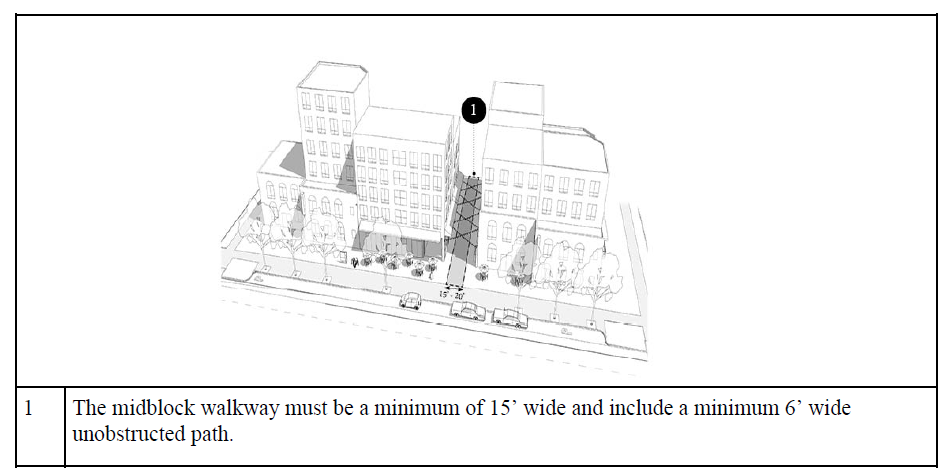
H. Midblock Walkways: As part of the city's plan for the downtown area, it is intended that midblock walkways be provided to facilitate pedestrian movement within the area. The city has adopted the Downtown Plan that includes a midblock walkway map and establishes a need for such walkways as the Downtown area grows. Because the districts within the downtown area allow building heights that exceed those of other districts in the city, the requirement for a midblock walkway is considered to be necessary to alleviate pedestrian impacts on the public sidewalks by dispersing future use of the public sidewalks. This requirement implements the city's Downtown Plan and provides visual relief from the additional height that is available in these zone districts when compared to the remainder of the city. All buildings constructed after the effective date hereof within the Downtown zoning districts shall conform to this officially adopted plan for midblock walkways, in addition to the following standards:
1. Any new development shall provide a midblock walkway if a midblock walkway on the subject property has been identified in a master plan that has been adopted by the city.
2. The following standards apply to the midblock walkway:
a. The midblock walkway must be a minimum of fifteen feet (15') wide and include a minimum six feet (6') wide unobstructed path.
b. The midblock walkway may be incorporated into the building provided it is open to the public. A sign shall be posted indicating that the public may use the walkway.
c. Building encroachments into the midblock walkway are permitted if they include one or more of the following elements:
(1) Colonnades;
(2) Staircases;
(3) Balconies - All balconies must be located at the third story or above;
(4) Building overhangs and associated cantilever - These coverings may be between nine feet (9') and fourteen feet (14') above the level of the sidewalk. They shall provide a minimum depth of coverage of six feet (6') and project no closer to the curb than three feet (3');
(5) Skybridge - A single skybridge is permitted. All skybridges must be located at the third, fourth, or fifth stories; and
(6) Other architectural element(s) not listed above that offers refuge from weather and/or provide publicly accessible usable space.
Illustration of Regulation 21A.26.070.H Midblock Walkways
I. Restrictions on Parking Lots and Structures: An excessive amount of at or above ground parking lots and structures can negatively impact the urban design objectives of the General Commercial (CG) District. To control such impacts, the following regulations shall apply to parking facilities that are at or above ground:
1. Parking shall be located behind principal buildings or incorporated into the principal building provided the parking is wrapped on street facing facades with a use allowed in the zone other than parking.
2. Parking lots not wholly behind the principal building are limited to no more than two double-loaded parking aisles (bays) adjacent to each other. The length of a parking lot shall not exceed ten (10) stalls.
3. No special restrictions shall apply to belowground parking facilities.
4. Parking structures shall conform to the requirements set forth in Chapter 21A.37 of this title.
5. All parking lot and structure landscaping must comply with the provisions set forth in Chapter 21A.48 of this title. (Ord. 12-24, 2024: Ord. 10-24, 2024: Ord. 24B-23, 2023: Ord. 24-23, 2023: Ord. 14-19, 2019: Ord. 66-13, 2013: Ord. 15-13, 2013: Ord. 12-11, 2011: Ord. 61-09 § 18, 2009: Ord. 3-01 § 2, 2001: Ord. 35-99 § 27, 1999: Ord. 26-95 § 2(13-6), 1995)
A. Purpose Statement: The purpose of the TSA Transit Station Area District is to provide an environment for efficient and attractive transit and pedestrian oriented commercial, residential and mixed use development around transit stations. Redevelopment, infill development and increased development on underutilized parcels should include uses that allow them to function as part of a walkable, mixed use district. Existing uses that are complementary to the district, and economically and physically viable, should be integrated into the form and function of a compact, mixed use pedestrian oriented neighborhood. Each transit station is categorized into a station type. These typologies are used to establish appropriate zoning regulations for similar station areas. Each station area will typically have two (2) subsections: the core area and the transition area. Due to the nature of the area around specific stations, the restrictions of overlay zoning districts, and the neighborhood vision, not all station areas are required to have a core area and a transition area.
1. Core Area: The purpose of the core area is to provide areas for comparatively intense land development with a mix of land uses incorporating the principles of sustainable, transit oriented development and to enhance the area closest to a transit station as a lively, people oriented place. The core area may mix ground floor retail, office, commercial and residential space in order to activate the public realm.
2. Transition Area: The purpose of the transition area is to provide areas for a moderate level of land development intensity that incorporates the principles of sustainable transit oriented development. The transition area is intended to provide an important support base to the core area and transit ridership as well as buffer surrounding neighborhoods from the intensity of the core area. These areas reinforce the viability of the core area and provide opportunities for a range of housing types at different densities. Transition areas typically serve the surrounding neighborhood and include a broad range of building forms that house a mix of compatible land uses. Commercial uses may include office, retail, restaurant and other commercial land uses that are necessary to create mixed use neighborhoods.
B. Station Area Types: A station area typology is the use of characteristics, such as building types, mix of land use, transit service and street network to create generalizations about an area that can be used to define a common vision for development of a transit station area. Each typology recognizes the important difference among places and destinations and takes into account the local context of a station and its surroundings. Refer to the official Salt Lake City zoning map to determine the zoning of the land within each station area.
1. Urban Center Station (TSA-UC): An urban center station contains the highest relative intensity level and mix of uses. The type of station area is meant to support downtown Salt Lake and not compete with it in terms of building scale and use.
2. Urban Neighborhood Station (TSA-UN): An evolving and flexible development pattern defines an urban neighborhood station area. Urban neighborhoods consist of multilevel buildings that are generally lower scale than what is found in the urban center station area. The desired mix of uses would include ground floor commercial or office uses with the intent of creating a lively, active, and safe streetscape.
3. Mixed Use Employment Center Station (TSA-MUEC): A mixed use employment station is an area with a high concentration of jobs that attract people from the entire region. Buildings are often large scale in nature and may have large footprints. Land uses that support the employment centers such as retail sales and service and restaurants are located throughout the station area and should occupy ground floor space in multi-story buildings oriented to the pedestrian and transit user. A mix of housing types and sizes are appropriate to provide employees with the choice to live close to where they work. Building types should trend toward more flexible building types over time. Connectivity for all modes of travel is important due to the limited street network.
4. Special Purpose Station (TSA-SP): The special purpose station is typically centered on a specific land use or large scale regional activity. These areas are generally served by a mix of transit options. Land uses such as restaurants and retail support the dominant land use and attract people to the area. A mix of housing types and sizes are appropriate in certain situations. Future development should be aimed at increasing the overall intensity and frequency of use in the station area by adding a mix of uses that can be arranged and designed to be compatible with the primary use.
C. Review Process: The review process for all new development and redevelopment within the Transit Station Area Zoning District is based on the development score which is generated by the "Transit Station Area Development Guidelines" hereby adopted by reference.
1. The following types of development are required to go through this review process:
a. Any addition of one thousand (1,000) square feet or more that extend a street facing building facade or are located to the side of a building and are visible from a public space; or
b. Additions that increase the height of an existing building or change the existing roofline;
c. Additions to the rear of buildings that are not adjacent to a public street, trail or other public space are not required to obtain a development score but must comply with all other applicable regulations. Signs, fences, accessory structures and any other structure or addition not listed in this section are not required to obtain a development score.
d. Single-family detached dwellings and two-family dwellings are not required to obtain a development score.
2. Application process steps:
a. Presubmittal Conference: All applicants for development within the TSA Transit Station Area Zoning District are required to attend a presubmittal conference with the planning division. The purpose of the presubmittal conference is to notify the applicant of the goals of the station area plans, the standards in this section, and the review and approval process.
b. Development Review Application: After a presubmittal conference, the developer can submit a development review application. This application and all submittal requirements will be used to determine the development score. The application shall include a score sheet on which the development guidelines and their assigned values are indicated and two (2) checklists: one for the applicant's use and one for the planning division's use.
c. Public Noticing: A notice of application for a development review shall be provided in accordance with Chapter 21A.10 of this title.
d. Application Review: Table 21A.26.078.C.2.d of this Subsection C summarizes the application review process. All applications shall be processed as follows:
(1) Tier 1 Planning Commission Review: If a project is assigned a score less than 125 points, the project can only be approved by the planning commission through the design review process in Chapter 21A.59 of this title. Once the applicant receives written notice of their score, they will be given thirty (30) days to notify the planning division of their intention to proceed with the project through the design review process or make necessary plan adjustments to increase their development score to the minimum level in order to go through an administrative review process.
(2) Tier 2 Administrative Review: The planning director has the authority to approve a project scoring 125 points or more without holding a public hearing. The project shall be allowed to go through the standard building permit process. A public hearing is not required because the project incorporates adequate development guidelines or development incentives to be deemed compliant with the vision for the station area.
TABLE 21A.26.078.C.2.d APPLICATION REVIEW
Development Score | Review Process |
0 - 124 points | Planning commission design review process |
125 or more points | Administrative review |
D. Development Score: The purpose of the development score is to allow flexibility for designers while implementing the city's vision of the applicable station area plans and the purpose of this zoning district. The development score measures the level of compatibility between a proposed project and the station area plan. A "station area plan" is a development, land use, urban design and place making policy document for the area around a specific transit station. The development score is based on the development guidelines and development incentives in the "Transit Station Area Development Guidelines" book, hereby adopted by reference. The "Transit Station Area Development Guidelines" shall be amended following the adopted procedures for zoning text amendments in Chapter 21A.50, "Amendments", of this title.
1. Formulating the Score: The development score is formulated by calculating all of the development guideline values for a particular project. Each design guideline and incentive is given a value based on its importance. Some guidelines are considered more important and carry a higher value than others. All other applicable zoning regulations shall be complied with by all projects and are not calculated in the development score.
2. Project Review: A development score shall be assigned to all projects within the TSA Transit Station Area District after a complete development review application is submitted. The planning director shall provide, in writing, a copy of the review checklist and explanation of the outcome of the score to the applicant within thirty (30) days of submitting a complete application.
3. Appeals: The development score may be appealed. All appeals of the development score are heard by the appeals hearing officer. In hearing the appeal, the appeals hearing officer shall hold a public hearing in accordance with Section 21A.10.030 of this title. In deciding the appeal, the appeals hearing officer shall base its decision on its interpretation of the development guidelines and the development score.
4. Expiration: No development score shall be valid for a period longer than one year unless a building permit has been issued or complete building plans have been submitted to the Division of Building Services.
E. Development Standards:
1. Application: The dimensional requirements of this section apply to all new buildings and developments as well as additions to existing buildings. Additions that bring the property closer to compliance are allowed. The following development standards apply to the core and transition areas of all station types.
2. Building Height: The minimum and maximum building heights are found in table 21A.26.078.E.2, "Building Height Regulations", of this subsection E.2. The minimum building height applies to all structures that are adjacent to a public or private street. The building shall meet the minimum building height for at least fifty percent (50%) of the width of the street facing building wall.
Minimum Height1 |
Maximum Height |
Minimum Height1 |
Maximum Height | |
Urban center: | ||
Core | 40' | 90'2 |
Transition | 25' | 60' |
Urban neighborhood: | ||
Core | 25' | 75' |
Transition | 0' | 50' |
Mixed use employment center: | ||
Core | 25' | 75' |
Transition | 0' | 60' |
Special purpose: | ||
Core | 25' | 75' |
Transition | 0' | 60' |
Notes:
1. Minimum building heights apply to those properties with frontage on the street where fixed rail transit is located.
2. Buildings with a roof that has at least 2 sloping planes may be allowed up to 105 feet. The slope of the plane must have a minimum slope of a 2 feet rise over a 12 foot run. The additional height may include habitable space. The sloping planes must be clearly visible and create a sloped roof shape. The sloping planes shall not be hidden by a parapet wall.
3. Setbacks:
a. General Standards for Front/Corner Side Yards:
(1) All portions of the yard not occupied by building, driveways, walkways or other similar features must be landscaped or include an active outdoor use, such as outdoor dining, plazas, courtyards or other similar outdoor use. See Subsection F of this section for specific front yard design requirements.
(2) Walls up to three feet (3') in height, patios and other similar elements intended to activate the sidewalk can be located to the property line.
(3) Awnings or canopies may be located within any portion of the yard and are not subject to the front or corner side yard restrictions in Subsection 21A.36.020.B, Table 21A.36.020.B of this title.
(4) Balconies may project up to two feet (2') into the required yards and are not subject to the front or corner side yard restrictions in Subsection 21A.36.020.B, Table 21A.36.020.B of this title.
(5) All front and corner side yard standards in Table 21A.26.078.E.3.b of this Subsection E may be modified through the design review process of Chapter 21A.59 of this title, except that the front and corner side yard setback for 400 South shall not be reduced below the minimum.
b. Table 21A.26.078.E.3.b Setback Standards:
Property Frontage | Front/Corner Side Yard Setback | Interior Side Yard | Rear Yard |
Property Frontage | Front/Corner Side Yard Setback | Interior Side Yard | Rear Yard |
400 South | Minimum: 10', and at least 50% of the street facing building facade must be built to the minimum | Minimum: None, except a 25' setback is required when abutting an OS, R-1, R-2, SR, RMF-30, RMF-35 or RMF-45 zoning district. The minimum shall increase 1' for every 1' increase in building height above 25' and is applied to the portion of the building over 25' in height. | |
Maximum setback: 20', but may be increased if the additional setback is used for plazas, courtyards, or outdoor dining areas. | |||
In locations where the sidewalk is not a minimum of 10' wide, additional sidewalk width shall be installed by the developer so there is a minimum width sidewalk of 10'. This applies to new buildings and to additions that increase the gross building square footage by more than 50%. This standard does not required removal of existing buildings or portions thereof. | |||
North Temple | Minimum: 5', and at least 50% of the street facing building facade must be built to the minimum. | ||
Maximum: 15', but may be increased if the additional setback is used for plazas, courtyards, or outdoor dining areas | |||
In locations where the sidewalk is not a minimum of 10' wide, additional sidewalk width shall be installed by the developer so there is a minimum width sidewalk of 10'. This applies to new buildings and to additions that increase the gross building square footage by more than 50%. This standard does not require removal of existing buildings or portions thereof. | |||
300 South, 500 South, 600 East | Minimum: Equal to the average setback of other principal buildings on the same block face. | ||
Streets with right- of-way width of 50' or less with R-1, R-2, SR, RMF-30, RMF- 35 or RMF-45 zoning district on either side of the street | Minimum: 25% of the lot depth, up to 25'. For buildings taller than 25', setback shall increase 2' for every 1' of building height above 25' and is applied to the portion of the building over 25' in height. | ||
All other streets | Minimum: None | ||
At least 50% of the street facing building facade shall be within 5' of the front or corner side property line. | |||
c. Special Setback Provisions for Properties Adjacent to Jordan River: For properties that are adjacent to the Jordan River, the building setback from the Jordan River shall be fifty feet (50'), measured from the annual high water level as defined in Section 21A.34.130 of this title. For buildings over fifty feet (50') in height, the setback shall increase one foot (1') for every foot in height over fifty feet (50') up to a maximum of seventy five feet (75'). Portions of buildings over fifty feet (50') in height may be stepped back to comply with this standard.
4. Minimum Lot Area and Lot Width Requirements:
Standard | Required Dimension |
Minimum lot area | 2,500 square feet |
Minimum lot width | 40 feet |
a. The minimum lot area applies to all new subdivisions of land and shall not be used to calculate residential density.
b. Any legally existing lot may be developed without having to comply with the minimum lot size or width requirements.
c. Lots subdivided for single-family detached, single-family attached, and two- family residential dwellings are exempt from minimum lot width requirements.
d. Lots subdivided for single-family attached dwellings are exempt from minimum lot area provided that:
(1) Parking for units shall be rear loaded and accessed from a common drive shared by all units in a particular development;
(2) Driveway access shall connect to the public street in a maximum of two (2) locations; and
(3) No garages shall face the primary street and front yard parking shall be strictly prohibited.
5. Open Space Area: Open space areas shall be provided at a rate of one square foot for every ten (10) square feet of land area included in the development, up to five thousand (5,000) square feet for core areas, and up to two thousand five hundred (2,500) square feet for transition areas. Open space areas includes landscaped yards, patios, public plazas, pocket parks, courtyards, rooftop and terrace gardens and other similar types of open space area amenities. All required open space areas shall be accessible to the users of the building(s).
6. Circulation and Connectivity: Development within the station area shall be easily accessible from public spaces and provide safe and efficient options for all modes of travel. Circulation networks, whether public or private, require adequate street, pedestrian and bicycle connections to provide access to development. The internal circulation network shall be easily recognizable, formalized and interconnected.
a. All parking lots shall comply with the standards in Section 21A.44.020, "General Off Street Parking Regulations", of this title.
b. Parking is prohibited between the street-facing building line and any front or corner side property line. This shall include any drive aisle that is not perpendicular to the front or corner side property line.
c. Any new development shall provide a midblock walkway if a midblock walkway on the subject property has been identified in a master plan that has been adopted by the city. The following standards apply to the midblock walkway:
(1) The midblock walkway must be a minimum of ten feet (10') wide and include a minimum six foot (6') wide unobstructed path.
(2) The midblock walkway may be incorporated into the building provided it is open to the public. A sign shall be posted indicating that the public may use the walkway.
7. Accessory Structures: No accessory structure shall be located in a required front yard or between the primary building and a property line adjacent to a public street.
F. Design Standards:
1. Development shall comply with the design standards in Chapter 21A.37 of this title when applicable as specified in that chapter.
2. All developments required to obtain a review score by Subsection C of this section shall comply with the following additional design standards. These specific standards may be modified through the design review in Chapter 21A.59 of this title if the modifications meet the intent of the specific design standard requested to be modified:
a. EIFS and Stucco Limitation: Use of Exterior Insulation and Finishing System (EIFS) or traditional stucco is not allowed as a building material on the ground floor of street facing building facades. Use of EIFS and stucco is allowed for up to ten percent (10%) of the upper level street facing facades.
b. Front and Corner Side Yard Design Requirements:
(1) In yards greater than ten feet (10') in depth, one shade tree shall be planted for every thirty feet (30') of street frontage. For the purpose of this section, a shade tree is any tree that has a mature minimum tree canopy of thirty feet (30') and a mature height that is forty feet (40') or greater.
(2) At least fifty percent (50%) of the front or corner side yards shall be covered in live plant material. This can include raised planter boxes. This percentage can be reduced to thirty percent (30%) if the yard includes outdoor dining, patios, outdoor public space, or private yards for ground floor residential uses that cover at least fifty percent (50%) of the provided front or corner side yard.
(3) At least thirty percent (30%) of the front or corner side yard shall by occupied by outdoor dining areas, patios, outdoor public space, or private yards for ground floor residential uses.
(4) Driveways necessary for vehicle access to the site are allowed regardless of compliance with the minimum percentages required by this subsection.
c. Entry Feature Requirements: All required building entries shall include at least one of the following features:
(1) An awning or canopy over the entrance that extends a minimum of five feet (5') from the street facing building facade;
(2) A recessed entrance that is recessed at least five feet (5') from the street facing facade;
(3) A covered porch that is at least five feet (5') in depth and at least forty (40) square feet in size; or
(4) A stoop that is at least two feet (2') above sidewalk level and that includes an awning or canopy that extends at least three feet (3') from the street facing building facade.
d. Ground Floor Use Requirement For 400 South and North Temple Boulevard: When facing 400 South or North Temple Boulevard, the ground floor use area required by Chapter 21A.37 of this title shall be built to accommodate an allowed commercial, institutional, or public use. Live/work uses qualify as a commercial use for this subsection.
(1) Exception: Residential uses may be permitted within the required area in lieu of the required use, if the ground floor is designed so that it can be converted to an allowed commercial use in the future. To accommodate this conversion, the shell space of the ground floor shall be built to an occupancy standard required by the adopted building code that can accommodate conversion of the interior of the space to a future permitted commercial use.
(2) The following additional requirements shall apply to the ground floor space if used for residential uses:
(A) The shell space shall be at least twelve feet (12') in height;
(B) The street facing facade of each ground floor residential unit shall be at least sixty percent (60%) glass;
(C) Each ground floor unit shall have a direct entrance from the sidewalk to the unit;
(D) Each ground floor unit shall be ADA accessible; and
(E) Each ground floor unit shall include a porch, patio, stoop or other entrance feature that is a minimum depth of at least five feet (5').
G. Multiple Buildings on a Single Parcel: Multiple principal buildings on a single parcel are permitted provided each principal building meets the requirements of this chapter and each principal building obtained a separate development score. New principal buildings can be located toward the rear of a parcel provided there is an existing or additional new principal building that complies with the front yard building setbacks. If one principal building receives a development score lower than other principal buildings on the site, the project shall be processed based on the lowest development score obtained. Multiple single-family detached dwellings and two-family dwellings may be located on one lot and are not required to obtain a development score.
H. Conflicting Regulations: In cases where the regulations of this section conflict with another section of this zoning ordinance, this section shall take precedence except in situations where the conflict is related to the use of the property, in which case the more restrictive regulation takes precedence. In station areas within an overlay district, the overlay district shall take precedence.
I. Developments Over Five Acres:
1. Intent: Large scale developments have the potential to function as a self-contained mixed use neighborhood and could have both positive and negative impacts on nearby properties. All developments over five (5) acres in size shall be designed and planned to include a series of blocks and a network of public or private streets that connects to the existing public streets in the area and to adjacent development and neighborhoods. Buildings should be oriented to this street network. Regulating block size is necessary to provide development sites that are oriented to the pedestrian while accommodating other modes of transportation. A street network is required to ensure adequate circulation for pedestrians, bicycles, automobiles and service vehicles through the site, to adjacent sites and the public streets.
2. Application: These standards are in addition to all other applicable standards. In situations where the standards in this section conflict with a standard in another section, the standard in this section shall take precedence. A separate development score is required for each new principal building in a development over five (5) acres.
a. Block Layout: The intent of regulating block size and dimension is to create a development pattern where all principal buildings have their primary facades facing a street, whether public or private. All developments over five (5) acres in size shall be designed to include a series of blocks based on the standards below:
(1) The maximum perimeter dimension of any block shall be one thousand six hundred feet (1,600'). The maximum length of any individual block face shall be four hundred forty feet (440').
(2) The maximum perimeter dimension of a block may be increased to two thousand four hundred (2,400) linear feet, and the maximum length of any block face increased to six hundred feet (600') provided a mid block pedestrian network is included. The mid block pedestrian network must be a minimum of twenty feet (20') wide and include pedestrian amenities such as lighting, benches, and other similar features. The mid block walkway shall connect to at least two (2) block faces or be extended to the property line to allow for future extension.
b. Connectivity to Public Streets, Sidewalks, and Bicycle Lanes: In order to ensure that the development will be fully integrated into the transit station area, that safe and efficient travelways are provided, and to limit the impact on the primary transit street and other adjacent streets, the internal circulation system, including private streets, drive aisles, sidewalks and bicycle lanes shall connect to the public street, sidewalks and bicycle lanes. All new streets shall be designed as a "complete street" defined as a street that provides dedicated space for pedestrians, bicyclists and automobiles.
c. Vehicle Access: Regulating access to private property from public streets is necessary for integrating private development and public spaces. Limiting the number of access points and spacing between access points reduces areas of conflict between vehicles, pedestrians and bicycles. Maximum access widths promote a development pattern that is oriented to pedestrians and bicyclists while accommodating vehicles.
(1) Access points located on public streets intended for vehicles shall be spaced a minimum of one hundred feet (100') apart.
(2) No property shall have more than one (1) vehicle access point for every two hundred (200) linear feet of frontage on a public street.
(3) No access drive shall be greater than twenty four feet (24') wide.
(4) The location of all vehicle access points is subject to approval from the transportation division of the city. The standards of this section may be modified by the Transportation Division when, in the opinion of the director of the transportation division, a different design would improve the overall safety for all modes of transportation or improve the efficiency of the transportation network.
d. Internal Circulation: Internal circulation systems allow for vehicles, pedestrians and bicyclists to move safely and efficiently throughout a development site. A logical, simple and well designed internal circulation system that connects with adjacent circulation networks provides room for vehicles, safe walking paths for pedestrians through the parking lot and the site to the public way, and well marked routes for bicycles traveling from public spaces to bicycle parking areas within a site. All new developments over five (5) acres are required to submit an internal circulation network plan.
(1) Travel Lanes That Connect Parking Areas With a Public Street: All internal vehicle travel lanes that connect internal parking areas with a public street shall be designed to meet the minimum requirements in Section 21A.44.060.A.6 of this title.
(2) Design Speed: The internal circulation system shall be designed to move vehicles at speeds of twenty (20) miles per hour or less.
(3) Future Access to Abutting Properties and Rights-Of-Way: All internal drive aisles, sidewalks, and paths shall be extended to property lines to allow for future cross access to abutting properties when the abutting property is undeveloped and to rights-of-way.
(4) Centerlines: The centerline of all internal streets shall be in line with the centerline of a street on the opposite side of an intersecting street unless the intersecting street is divided by a median. Offset streets shall be a minimum of two hundred feet (200') apart, measured from centerline to centerline.
(5) Publicly Dedicated Streets: Any street that is to be publicly dedicated shall meet the city's minimum construction and design standards (including street lighting, park strip, street trees, etc.).
(6) Pedestrian Routes: Pedestrian routes that provide safe, comfortable, clear and direct access throughout the development shall be provided. Pedestrian paths shall be bordered by residential fronts, green space, active open space, or commercial storefronts.
(7) Bicycle Paths: A coordinated system of bicycle paths should be provided.
(8) Approval; Modification of Standards: The internal circulation network is subject to approval from the transportation division of the city. The standards of this section may be modified by the transportation division when, in the opinion of the director of the transportation division, a different design would improve the overall safety for all modes of transportation or improve the efficiency of the transportation network.
e. Parking: Parking may be provided along any private street within a development over five (5) acres. The parking shall be counted toward the applicable off street parking standard when provided on private streets. All parking areas and spaces must comply with the parking lane widths identified in Section 21A.44.060.A.6 of this title.
f. Open Space Area: In order to provide space for passive and active recreation, public and private gatherings, offset storm drainage due to nonpem1eable surfaces and as an amenity to individual developments and their residents, employees and customers, usable open space areas are required for all new developments.
(1) Required: In the core and transition areas of all station areas, a minimum of ten percent (10%) of the site, up to fifteen thousand (15,000) square feet, shall be devoted to open space areas. "Usable open space area" is defined as landscaped areas, plazas, outdoor dining areas, terraces, rooftop gardens, stormwater retention areas, and any other similar type of area.
(2) Connectivity to Adjacent Open Space Area: When adjacent to public open space areas, parks, trails and pathways, open space areas on developments over five (5) acres in size are encouraged to provide access to the public open space area.
g. Landscaping: All areas not occupied by buildings, plazas, tell"aces, patios, parking areas, or other similar feature shall be landscaped. lf a project is developed in phases, only those areas in a phase that is under construction shall be landscaped. Landscaping in future phases shall be installed as those phases develop. Areas in future phases may be used as community gardens or other active open space until such time as development of that phase begins. (Ord. 10-24, 2024: Ord. 74-23, 2023: Ord. 67-22, 2022: Ord. 14-19, 2019: Ord. 13-19, 2019: Ord. 25-17, 2017)