Loading...
The requirements of this section are not applicable to wetlands or waters of the U.S. that, in either case, are below the threshold-size limitations for mitigation requirements under the COE 404 permit program.
(A) Buffers shall be identified on development plans for all areas defined as waters of the U.S. Buffer areas are divided into two types: linear buffers and water body buffers.
(1) Buffer areas, including the protected waters of the U.S., shall be shown to be within appropriate easements on all new plats. Additionally, the maintenance requirements for the buffer shall be noted on the plat or included as a covenant running with the land in any deed conveying any portion of a buffer area.
(2) Buffer widths required as a part of a COE permit supersede the widths required in this section, unless the width required herein is greater. If a COE permit is obtained to permanently fill a portion of a wetland and no buffer is required, the buffer width required by this subchapter immediately adjacent to the area of impact does not apply. IMMEDIATELY ADJACENT refers to the area within 15 feet of the area of impact. In no case shall additional wetland area be filled to provide buffer required by this subchapter.
(3) Jurisdictional waters of the U.S. or wetlands may not constitute a buffer. Buffer widths are to be 25 feet unless otherwise determined using the criteria specified below. Buffer width averaging is acceptable at the discretion of the Administrator. When using buffer width averaging, the width may not be more than 20% less, at the narrowest point, than the specified width. The buffer width may never be less than 15 feet, except in the case of waters of the U.S. or wetlands with a calculated FQI of less than seven, where the buffer at its narrowest point may not be less than 12 feet in width.
(a) Linear buffers shall be designated along waters of the U.S. and wetlands associated with water courses, i.e., swales, creeks, streams, rivers, and the like. Refer to division (A)(3)(b) below in cases where wetlands are adjacent to and not part of the main channel, i.e., floodplain wetland, backwater slough, oxbow, bordering wetland complex.
1. When the lineal waters of the U.S. have a drainage area greater than 640 acres, measured at the downstream property line, or is designated as ADID because of high habitat value or an adjacent wetland has a calculated FQI greater than 16, the buffer shall be 50 feet.
2. When the lineal waters of the U.S. have a drainage area less than 640 acres, measured at the downstream property line, the buffer width shall be determined utilizing the formula,
X = (A*0.0547)+ 15
Where X equals the buffer width in feet, and A equals the drainage area in acres.
The width calculated by this formula shall be rounded up to the nearest multiple of five.
3. If protective measures are installed along the perimeter of a buffer, the width may be reduced by up to 10% immediately adjacent to the protective measure. The reduction in width that may be applied due to installation of protective measures may not be applied where buffer width averaging has been used and the buffer would be more than 20% less than originally specified. Protective measures may consist of fencing, sediment basins, biological filter strips or other methods approved by the Administrator.
4. If lineal waters of the U.S. are completely or partially relocated, the newly created portion must be constructed in a manner that will allow naturalizing to occur; for example, meandering, pools, riffles and the like. Additionally, all disturbed areas must be replanted for stability with native vegetation where appropriate, appropriately managed and maintained and protected by an appropriately-sized buffer.
(b) Water body buffers shall encompass non-linear bodies of water meeting the definition of the waters of the U.S., including wetlands.
1. If protective measures are installed along the perimeter of a buffer, the width may be reduced by up to 10% immediately adjacent to the protective measure. The reduction in width that may be applied due to installation of protective measures may not be applied where buffer width averaging has been used and the buffer would be more than 20% less than originally specified. Protective measures may consist of fencing, sediment basins, biological filter strips or other methods approved by the Administrator.
2. For all non-lineal water bodies or waters of the U.S. designated as ADID or wetlands with an FQI greater than 16, a minimum buffer width must be established in accordance with Table 1.
3. For non-ADID wetlands with an FQI of 7 to 16, a minimum buffer width must be established in accordance with Table 2.
4. For non-ADID wetlands with an FQI of less than 7, a minimum buffer width must be established in accordance with Table 3.
(B) Buffers shall be replanted or reseeded using appropriate predominately-native, deep-rooted vegetation, appropriately managed and maintained following disturbance.
(C) The buffer area for all lineal and non-lineal waters of the U.S., except wetlands, shall extend from the jurisdictional limits of the waters of the U.S. ordinary high water mark. The buffer area for wetlands shall extend from the edge of the approved delineated wetland boundary. A site may contain a buffer that originates from a waters of the U.S. or wetland located on another property.
(D) Constructed stormwater management features shall not require a buffer and may constitute as a buffer. The total width of the buffer required may not be reduced by the installation of a stormwater management facility unless the facility can be considered a protective measure. If the facility can be considered to be a protective measure, then the width of the buffer may be reduced as specified in this subchapter.
(E) If a buffer area is disturbed by permitted activities during construction, the buffer strip shall be stabilized in accordance with this subchapter.
(F) Access through buffer areas shall be allowed when necessary for maintenance purposes only. Unless otherwise dedicated for a public purpose, buffer areas shall remain private property and are not generally accessible to the public.
(G) Unrestrained stormwater that has not passed through a site runoff storage facility shall discharge through an area or structure meeting the definition of best management practices or buffer before entering the jurisdictional waters of the U.S. or a wetland.
(1) Once established, all buffer areas shall be maintained free from development, except as described below:
(a) A buffer area may be used for passive recreation (e.g., bird watching, walking, jogging, bicycling, horseback riding and picnicking), and it may contain pedestrian, bicycle or equestrian trails, provided that the created path is no wider than ten feet. To help prevent erosion, paths leading to a wetland must be winding.
(b) Utility maintenance, maintenance of drainage facilities and drainage easements shall be allowed, provided the maintenance activity meets all other federal, state and local regulations.
(c) Anchoring and placement of boat docks and piers shall be allowed, provided the structure meets all other federal, state and local regulations.
TABLE 1 – HIGH QUALITY WETLANDS – FQI > 16 | |||
Buffer Ratio | Wetland Area (Acres) | Buffer Area (Acres) | Buffer Width (Feet) |
0.5 | 0.25 | 0.125 | 15.0 |
0.5 | 0.5 | 0.25 | 20.0 |
0.5 | 0.75 | 0.375 | 25.0 |
0.5 | 1.0 | 0.5 | 30.0 |
0.5 | 1.25 | 0.625 | 30.0 |
0.5 | 1.5 | 0.75 | 35.0 |
0.5 | 1.75 | 0.875 | 35.0 |
0.5 | 2.0 | 1.0 | 40.0 |
0.5 | 2.25 | 1.125 | 40.0 |
0.5 | 2.5 | 1.25 | 45.0 |
0.5 | 2.75 | 1.375 | 45.0 |
0.5 | 3.0 | 1.5 | 50.0 |
0.5 | 3.25 | 1.625 | 50.0 |
0.5 | 3.5 | 1.75 | 50.0 |
0.5 | 3.75 | 1.875 | 50.0 |
0.5 | 4.0 | 2.0 | 50.0 |
0.5 | 4.25 | 2.125 | 50.0 |
0.5 | 4.5 | 2.25 | 50.0 |
0.5 | 4.75 | 2.375 | 50.0 |
0.5 | 5.0 or more | 2.5 | 50.0 |
Buffer ratio = % of total wetland area
Wetland Area = Total onsite and offsite area of the wetland
Buffer Area = Wetland Area x Buffer Ratio
Buffer Width = 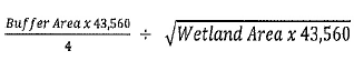
TABLE 2 – MEDIUM QUALITY WETLANDS – 7 < FQI < 16 | |||
Buffer Ratio | Wetland Area (Acres) | Buffer Area (Acres) | Buffer Width (Feet) |
0.4 | 0.25 | 0.1 | 15.0 |
0.4 | 0.5 | 0.2 | 15.0 |
0.4 | 0.75 | 0.3 | 20.0 |
0.4 | 1.0 | 0.4 | 25.0 |
0.4 | 1.25 | 0.5 | 25.0 |
0.4 | 1.5 | 0.6 | 30.0 |
0.4 | 1.75 | 0.7 | 30.0 |
0.4 | 2.0 | 0.8 | 30.0 |
0.4 | 2.25 | 0.9 | 35.0 |
0.4 | 2.5 | 1.0 | 35.0 |
0.4 | 2.75 | 1.1 | 35.0 |
0.4 | 3.0 | 1.2 | 40.0 |
0.4 | 3.25 | 1.3 | 40.0 |
0.4 | 3.5 | 1.4 | 40.0 |
0.4 | 3.75 | 1.5 | 45.0 |
0.4 | 4.0 | 1.6 | 45.0 |
0.4 | 4.25 | 1.7 | 45.0 |
0.4 | 4.5 | 1.8 | 45.0 |
0.4 | 4.75 | 1.9 | 50.0 |
0.4 | 5.0 or more | 2.0 | 50.0 |
Buffer ratio = % of total wetland area
Wetland Area = Total onsite and offsite area of the wetland
Buffer Area = Wetland Area x Buffer Ratio
Buffer Width =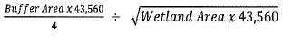
TABLE 3 – LOW QUALITY WETLANDS – FQI < 7 | |||
Buffer Ratio | Wetland Area (Acres) | Buffer Area (Acres) | Buffer Width (Feet) |
0.3 | 0.25 | 0.075 | 15.0 |
0.3 | 0.5 | 0.15 | 15.0 |
0.3 | 0.75 | 0.225 | 15.0 |
0.3 | 1.0 | 0.3 | 20.0 |
0.3 | 1.25 | 0.375 | 20.0 |
0.3 | 1.5 | 0.45 | 20.0 |
0.3 | 1.75 | 0.525 | 25.0 |
0.3 | 2.0 | 0.6 | 25.0 |
0.3 | 2.25 | 0.675 | 25.0 |
0.3 | 2.5 | 0.75 | 25.0 |
0.3 | 2.75 | 0.825 | 30.0 |
0.3 | 3.0 | 0.9 | 30.0 |
0.3 | 3.25 | 0.975 | 30.0 |
0.3 | 3.5 | 1.05 | 30.0 |
0.3 | 3.75 | 1.125 | 35.0 |
0.3 | 4.0 | 1.2 | 35.0 |
0.3 | 4.25 | 1.275 | 35.0 |
0.3 | 4.5 | 1.35 | 35.0 |
0.3 | 4.75 | 1.425 | 35.0 |
0.3 | 5.0 | 1.5 | 35.0 |
Buffer ratio = % of total wetland area
Wetland Area = Total onsite and offsite area of the wetland
Buffer Area = Wetland Area x Buffer Ratio
Buffer Width = 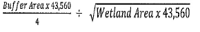
(Ord. 2019-03, passed 4-15-2019)
(A) Wetlands identified as having a Flora Quality Index (FQI) greater than or equal to 25 shall not be filled or dredged as part of any development. The FQI shall be based solely on the wetland vegetation. Buffers and adjacent plant communities shall not be included in the calculation.
(B) If the application of this section would:
(1) Have the effect of depriving the owner of all economically beneficial or productive use of the land; or
(2) Make the construction or installation of an essential public improvement by a public entity impossible or highly impractical;
the applicant may apply for a variance from the requirements of this subchapter. If such variance is granted, mitigation for the wetland impact allowed shall be made pursuant to this subchapter.
(Ord. 2019-03, passed 4-15-2019)
All mitigable wetland impacts shall be mitigated as required under the COE 404 permit program.
(A) For all mitigable wetland impacts:
(1) Mitigation may be made within a wetland mitigation facility;
(2) Mitigation may be made by the purchase of credits from a wetland mitigation bank; and
(3) Mitigation may be made by the payment of a fee-in-lieu of mitigation pursuant to this subchapter.
(B) Wetland impacts upon wetlands with an FQI of 7 or more, but less than 16, shall be mitigated at a ratio of 2:1.
(C) Wetland impacts upon wetlands with an FQI of 16 or more, but less than 25, shall be mitigated at a ratio of 3:1.
(D) Wetland impacts upon wetlands with an FQI of more than 25 shall be mitigated at a minimum ratio of 10:1, plus one half for each point by which the FQI exceeds 25, rounded up to the nearest whole number.
(E) Wetland impacts upon wetlands that are inhabited by a threatened or endangered species shall be mitigated at a ratio of 3:1.
(F) Mitigation for wetland impacts upon more than one wetland within a site shall meet the standards applicable to each individual wetland that is impacted.
(G) FQI assessments made before June 1 or after October 15 shall be considered to be preliminary. Mitigation requirements based upon such a preliminary assessments shall not be considered to be final until a proper final FQI assessment is made, unless an FQI of at least 16 is applied to the mitigation. Preliminary FQI assessments that exceed 16 will require final FQI assessments.
(H) The applicant may propose an alternative mitigation plan combining wetland creation, purchase of credits from a wetland mitigation bank, payment of a fee-in-lieu of wetland mitigation and/or enhancing existing wetlands, either onsite or offsite. The Administrator shall determine if a proposed alternative mitigation plan meets the requirements of this section and his or her decision shall be final.
(Ord. 2019-03, passed 4-15-2019)
(A) In addition to the requirements of this subchapter, if wetland mitigation is required, a wetland mitigation plan shall be submitted and contain the following information:
(1) A narrative of the proposed plan, including a description of the proposed hydrologic regime, soils and site geomorphology, where applicable;
(2) Drawings depicting each wetland impacted and each wetland mitigation facility, together with an individual listing contained in a summary table;
(3) Specifications for rough and final grading, soil types, soil placement, plant procurement, water control structures, and a planting plan that lists the plant materials by scientific and common name, seeding rate or spacing distance, and special planting provisions; and
(4) Maintenance and monitoring provisions, including an annual work schedule describing each task in detail and the time of year when it will be performed.
(B) The wetland mitigation plan shall be designed to provide the following information:
(1) Every wetland mitigation facility shall contain at least two wetland plant communities (for example, wet prairie, emergent, submergent, floating vascular, forested wetland, sedge meadow, or hemi-march); and
(2) Open water shall not constitute more than 20% of the entire wetland mitigation facility, except for hemi-marshes.
(Ord. 2019-03, passed 4-15-2019)
Wetland mitigation facilities shall be buffered according to the requirements of this subchapter. Reductions are allowed in accordance with § 151.217. No buffer is required for that portion of a wetland mitigation facility adjacent to an existing preserved wetland.
(Ord. 2019-03, passed 4-15-2019)
(A) All wetland mitigation facilities shall meet the following performance standards:
(1) They shall meet the definition of a wetland set forth in § 151.201;
(2) All vegetated zones within any wetland mitigation facility shall achieve 85% cover;
(3) The emergent community shall achieve 60% aerial coverage;
(4) The floating vascular community shall meet 25% aerial coverage; and
(5) Open water shall have 0% vegetative coverage.
(B) A wetland mitigation facility designed to mitigate for impacts upon wetlands with a FQI of less than 7 shall achieve a minimum FQI three points greater than the FQI of the wetland impacted within the five-year monitoring period.
(C) A wetland mitigation facility designed to mitigate for impacts upon wetlands with an FQI of 7 or more but less than 25 shall achieve a minimum FQI five points greater than the FQI of the wetland impacted within the five-year monitoring period.
(Ord. 2019-03, passed 4-15-2019)
(A) A stormwater management permit is required if:
(1) The development is located in the regulatory floodplain;
(2) A substantial improvement is to be located in the regulatory floodplain;
(3) There is any regulatory floodplain within the site; or
(4) The development disturbs more than 10,000 square feet of ground or 500 cubic yards of soil, unless the development consists solely of:
(a) The installation, renovation or replacement of a septic system, potable water service line or other utility serving an existing structure;
(b) The maintenance, repair or at-grade replacement of existing lawn areas not otherwise requiring a stormwater permit under this subchapter;
(c) The maintenance of an existing stormwater facility, not requiring other state or federal permits or approvals;
(d) Construction of a dwelling or development within a subdivision in which the village approved a final subdivision plat.
(B) All appropriate stormwater management related approvals and permits, including, without limitation, an IDNR-OWR floodway/floodplain construction permit, a COE 404 permit and an IDNR-OWR dam safety permit, if required, shall be obtained from all federal, state and regional authorities prior to the issuance of a stormwater management permit.
(C) At the time an applicant files his or her application for a stormwater management permit, site plan review, subdivision, planned unit development or annexation, the applicant shall deposit with the village the sum of $3,000 as a security deposit for the payment and satisfaction of the costs, engineering, planning, legal and other professional fees. This sum shall be returned to the applicant within 60 days following the complete payment and satisfaction of all sums due herein. In the event the applicant fails to satisfy the financial obligations herein, the village may apply all or any portion of the security deposit against the obligation. The village may maintain an action at law or in equity to enforce the provisions of this section. The applicant shall be responsible for all costs and attorney’s fees incurred by the village in the enforcement of the provisions of this section, whether or not suit is filed. The Building and Zoning Officer is authorized to issue a stop-work order, if applicable, until the applicant pays and satisfies his or her obligations in full.
(D) At the time an applicant files his or her application for the issuance of a stormwater management permit, the village shall furnish the applicant with a form that shall read substantially as follows:
APPLICANT:
Date:
The following firm, representative, agent or individual does hereby state that it has been fully disclosed to said party that, in order for the village to properly review and evaluate requests for a stormwater management permit, the village must necessarily utilize and engage the services of engineering, planning, legal and other professional consultants. The undersigned hereby agrees to pay to the village, either by reimbursement or directly to the professionals providing services, the reasonable costs incurred by the village for such services pertaining to the request of a stormwater management permit. It is further understood and agreed that all invoices for such services shall be paid promptly when submitted, but not later than 30 days, and that the obligation to reimburse the village or pay the professionals providing said services directly is binding, whether or not a stormwater management permit is in fact approved.
Applicant
(E) A topographical map of the site, record drawings and other required drawings shall be prepared, signed and sealed by a professional land surveyor or professional engineer, and shall include the following documentation.
(1) The design of stormwater facilities, calculations for the determination of the regulatory floodplain, and calculations of the impacts of development shall meet the standards of this subchapter, and shall be prepared, signed and sealed by a professional engineer. The signature and seal of the professional engineer shall stand as his or her opinion that the submittals that accompany the permit application meet the requirements of this subchapter.
(2) Differential water pressure for the stormwater management project shall conform to IDNR-OWR Part 3702, Construction and Maintenance of Dams, for classification and permitting.
(F) No person, firm, corporation or governmental body not exempted by law shall commence any development in the floodplain without first obtaining a development permit from the village. The application for a development permit shall be accompanied by:
(1) Drawings of the site, drawn to scale, showing property line dimensions;
(2) Existing grade elevations and all changes in grade resulting from excavation or filling;
(3) The location and dimensions of all buildings and additions to the buildings;
(4) The elevation of the lowest floor (including basement) of all proposed buildings subject; and
(5) The cost of the project or improvements, as estimated by a licensed engineer or architect registered in the State of Illinois. A signed estimate by a contractor may also meet this requirement.
(Ord. 2019-03, passed 4-15-2019)
Loading...