Loading...
All land which may hereafter be annexed to the village shall automatically be classified in the E-R, Estate Residential District (ILCS Ch. 65, Act 5, § 7-1-47). If land is to be classified other than the E-R District the Village President and Board of Trustees shall refer the zoning request to the Village Planning and Zoning Commission (the “Commission”), where the Commission shall within 60 days after the referral, schedule and hold a public hearing with respect to the zoning classification, pursuant to the provisions of §§ 159.177, Annexation Procedures; 159.178, Fee Schedule; and, 159.060, Summary Tables of this chapter.
The Commission shall make findings and recommendations with respect to the appropriate zoning classification or classifications being requested for the land and transmit them in writing to the Village President and Board of Trustees.
GENERAL REGULATIONS
(A) No building, structure, or land shall hereafter be used or occupied, and no building or part thereof, or other structure, shall be erected, raised, moved, reconstructed, extended, enlarged, or altered except in conformity with the regulations herein specified in the district in which it is located.
(B) All new buildings and structures shall conform to the building regulations established herein for the district in which each building shall be located, except that parapet walls, chimneys, cooling towers, elevator bulkheads, fire towers, stacks, and necessary mechanical appurtenances shall be permitted to exceed the maximum height provisions when erected in accordance with all other ordinances of the village.
(C) The maintenance of yards, courts, and other open space and minimum lot area legally required for a building shall be a continuing obligation of the owner of the buildings or of the property on which it is located, as long as the building or the property on which it is located, as long as the building is in existence. No legally required yards, courts, other open space, or minimum lot area allocated to any building shall, by virtue of change of ownership or for any other reason be used to satisfy yard, court, other open space, or minimum lot area requirements for any other building.
(D) No zoning lot improved with a building or buildings shall hereafter be divided into two or more zoning lots and no portion of any zoning lot which is improved with a building or buildings shall be sold, unless all zoning lots resulting from each division or sale and improved with a building or buildings shall not be less conforming to all bulk regulations of the zoning district in which the property is located.
(E) All location of required open spaces or yards or courts and other open space allocated to a building or dwelling group shall be located on the same zoning lot as the building or dwelling group, except as otherwise permitted in planned development and planned open spaces.
(F) No yards now or hereafter provided for a building existing on the effective date of this chapter shall subsequently be reduced below, or further reduced below if already less than, the minimum yard requirements of this chapter for equivalent new construction, except as provided in § 159.141.
(G) No landscaping or other obstructions shall, after the date of the adoption of this section, be installed or located within the sight triangle, as described in § 159.014.
(Ord. 07-0508, passed 2-21-07; Am. Ord. 08-0715, passed 11-19-08; Am. Ord. 09-0799, passed 12-16-09; Am. Ord. 15-1229, passed 11-18-15)
(A) Intent and purpose.
(1) The following section pertains to the clear line of sight at intersections of streets and major driveways. The criteria are based on American Association of State Highway and Transportation Officials (AASHTO) and the Illinois Department of Transportation (IDOT) design procedures. This section has been adopted to provide for safe turning movements by providing clear visibility zones at intersections clear of obstructions such as trees, walls, signs, buildings, etc. This policy is not intended for determining traffic controls at intersections. The need for traffic controls is to be assessed by the rules and regulations contained in the Manual on Uniform Traffic Control Devices and as recommended by the Village Engineer.
(2) The application of intersection sight distance and stopping sight distance shall extend to all proposed and existing public street intersections and all proposed and existing intersections of private streets and drives with public streets, including multi-family and commercial entrances. This also includes local to local intersections such as those within proposed subdivisions. The village requires that both intersection and stopping sight distances shall be shown with their geometries on all final construction drawings and be analyzed during the traffic impact study process.
(B) Visual obstructions. Visual obstructions shall be defined as any object within intersection sight triangles between the heights of no more than three feet measured relative to the elevation of the nearest pavement crown. This is based on a driver eye height of three feet and an object height of three feet (AASHTO and IDOT). Overhanging branches or other elevated obstructions may not be any lower than ten feet measured relative to the elevation of the nearest pavement crown.
(C) Stop sign controlled intersections. In determining the area of the sight triangle for intersections with stop sign control, the following criteria shall be used:
(1) One-way stop control: The sight triangles for a stop controlled minor road at a T-intersection with left turns allowed shall be the same as for the two way stop control.
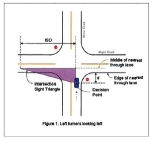
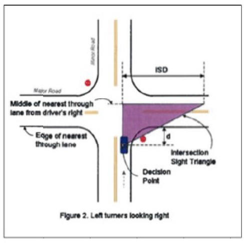
(2) Two-way stop control: The sight triangles for a stop controlled minor road with left turns allowed shall be based on Figures 1 & 2 and Tables 1 & 2. The left turning movement requires a longer intersection sight distance than the right turning movement; therefore, the criteria for the left turn conditions apply.
(a) Figure 1. Left turners looking left.
(b) Figure 2. Left turners looking right.
(c) Figure definitions and calculations.
1. ISD = Intersection Sight Distance. See table 1 and table 2.
2. d = Distance from the edge of nearest through lane to the decision point; 18 ft. preferred, 14.5 ft. minimum (AASHTO 2004). Any distance other than 18 ft. must be approved by the Village Engineer.
(d) Table 1.
Table 1. Intersection Sight Distance for Passenger Cars at Stop Controlled Intersections - Left turners looking left | ||||||||
Design Speed of Major Road (mph) | 20 | 25 | 30 | 35 | 40 | 45 | 50 | 55 |
ISD: Intersection Sight Distance (ft) Based on the equation below | 225 | 280 | 335 | 390 | 445 | 500 | 555 | 610 |
(e) Table 2.
Table 2. Intersection Sight Distance for Passenger Cars at Stop Controlled Intersections - Left turners looking right | ||||||||
Design Speed of Major Road (mph) | 20 | 25 | 30 | 35 | 40 | 45 | 50 | 55 |
ISD: Intersection Sight Distance (ft) Based on the equation below | 225 | 280 | 335 | 390 | 445 | 500 | 555 | 610 |
(f) Table definitions and calculations. Based on AASHTO - Geometric Design of Highways and Streets (2004) and IDOT BLR Sections 28 & 36.
1. Intersection Sight Distance (ISD) = Design speed (mph) x 1.47 x time gap (sec)
2. Intersection Sight Distance (ISD) - length of the leg of the sight triangle along the major roadway (ft)
3. Design speed of the major roadway (typically 5 mph over the posted speed limit)
4. 1.47 - conversion from mph to fps
5. Time gap is (7.5 sec - passenger car; 9.5 sec - single-unit truck; 11.5 sec - tractor/semitrailer) for a turning vehicle to enter a 2-lane major road without a median from a minor road with 3% or less grade. If the major road is multi-lane or has a median, add 0.5 sec per additional 12 feet crossed to turn left. If the minor road grade is >3%, add 0.2 sec per percent grade above.
(3) Right out only, stop control: The sight triangle for a stop controlled intersection with only right turns allowed from the minor road shall be based on Figure 3 and Table 3.
(a) Figure 3. Right turners looking left.
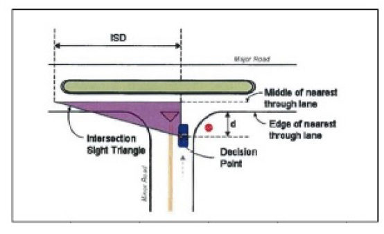
(b) Figure definitions and calculations.
1. d = Distance from the edge of nearest through lane to the decision point; 18 ft. preferred, 14.5 ft. minimum (AASHTO 2004). Use 15 ft. unless otherwise approved by the Village Engineer.
(c) Table 3.
Table 3. Intersection Sight Distance for Passenger Cars at Right Out Only - Right turners looking left | ||||||||
Design Speed of Major Road (mph) | 20 | 25 | 30 | 35 | 40 | 45 | 50 | 55 |
ISD: Intersection Sight Distance (ft) Based on the equation below | 195 | 240 | 290 | 335 | 385 | 430 | 480 | 530 |
(d) Table definitions and calculations. Based on AASHTO - Geometric Design of Highways and Streets (2004) and IDOT BLR Sections 28 & 36.
1. Intersection Sight Distance (ISD) = Design speed (mph) x 1.47 x time gap (sec)
2. Intersection Sight Distance (ISD) - length of the leg of the sight triangle along the major roadway (ft)
3. Design speed of the major roadway (typically 5 mph over the posted speed limit)
4. 1.47 - conversion from mph to fps
5. Time gap is (6.5 sec - passenger car; 8.5 sec - single-unit truck; 10.5 sec - tractor/semitrailer) for a turning vehicle to turn right from a minor road with 3% or less grade. If the minor road grade is >3%, add 0.2 sec per percent grade above 3.
(4) All-way stop control: The first stopped vehicle on one approach should be visible to the drivers of the first stopped vehicles on each of the other approaches.
(D) Traffic signal controlled intersections. The sight triangles for a traffic signal controlled intersection shall be described by the following conditions at each approach;
(1) Signals with off peak or night time flash operations shall follow the criteria for two way stop sign control on the red flashing approaches (Figures 1 & 2 and Tables 1 & 2).
(2) Signal approaches with right turns on red allowed that are not defined by IIA, shall follow the criteria for right out only, stop control (Figure 3 and Table 3.)
(3) Signal approaches not described by the conditions in either IIA or IIB shall use an intersection sight distance based on all-way stop control (ID).
(E) Yield controlled intersections. The sight triangles for a yield controlled intersection shall be described by the following conditions at each approach. Please note this information is referenced from the Guide for the Development of Bicycle Facilities, AASHTO, 4th Edition, 2012.
(1) Intersections that are not controlled by stop signs or signals are to be considered as yield-controlled intersections.
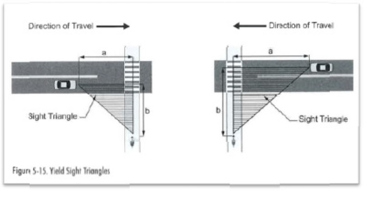
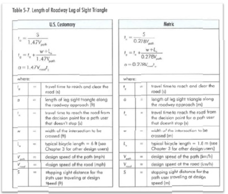
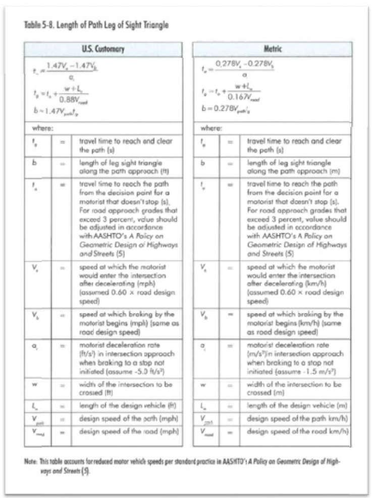
(2) For yield-controlled intersections between multi-use paths and roadways use the following figures/tables to calculate the appropriate sight triangles. Approach sight triangles depend on the design speeds of both the path and the roadway. If yield control is to be used for either approach, it is desirable that available sight distance be adequate for a traveler on the yield-controlled approach to slow, stop, and to avoid a traveler on the other approach. The roadway leg of the sight triangle is based on bicyclists' ability to reach and cross the roadway if they do not see a potentially conflicting vehicle approaching the roadway, and have just passed the point where they can execute a stop without entering the intersection. Figure 5-15, Table 5-7 (For Roadway Leg), and Table 5-8 (For Path Leg) shall be used for this condition.
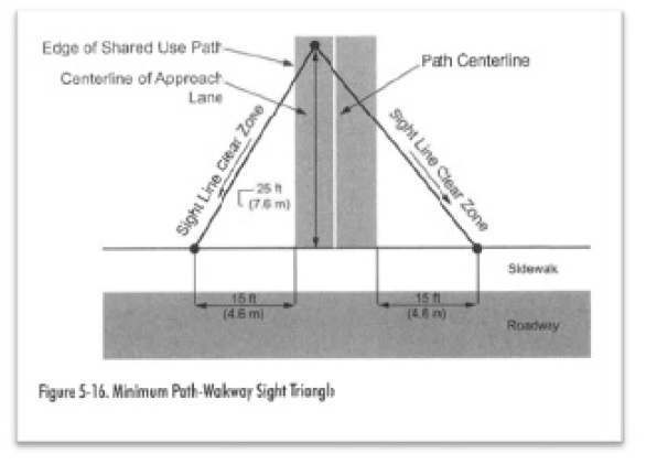
(3 ) For an uncontrolled intersection of a shared use path with a walkway (i.e, under yield control), a clear sight triangle extending at least 15 feet along the walkway should be provided (see Figure 5-16).
(4) If a shared use path intersects with another shared use path, sight triangles should be provided similar to a yield condition at a path-roadway intersection. However, both legs of the sight triangle should be based on the stopping sight distance of the paths. Use the equation in Table 5-7 for both legs of the sight triangle.
(Ord. 15-1229, passed 11-18-15)
STRUCTURE OR USE | FRONT YARD | CORNER SIDE YARD | REAR YARD | SIDE YARD
| STRUCTURE OR USE | FRONT YARD | CORNER SIDE YARD | REAR YARD | SIDE YARD
|
STRUCTURE OR USE | FRONT YARD | CORNER SIDE YARD | REAR YARD | SIDE YARD
| STRUCTURE OR USE | FRONT YARD | CORNER SIDE YARD | REAR YARD | SIDE YARD
| |
Air conditioner condenser unit, window units | P | P | P | P | Gazebos, and pergolas | P | ||||
Animal houses, for domestic animals, not to exceed 16 square feet in area and 4 feet in height | P | Greenhouse, private in accordance with § 159.020
| P | |||||||
Antenna, freestanding, for non-commercial purposes | P | Lamp posts | P | P | P | P | ||||
Arbors, trellises | P | P | P | P | Landscaping | P | P | P | P | |
Architectural ornamentation, e.g. sills, belt courses, cornices | P | P | P | P | Laundry drying (clotheslines) | P | ||||
Awnings and canopies, projecting no more than 48 inches from the structure | P | P | P | P | Lawn and garden ornaments, sculpture and statuary less than 3 feet in height, and garden furniture | P | P | P | P | |
Basketball backboards, located no less than 6 feet from any public sidewalk and 5 feet from any lot line | P | P | P | P | Outdoor storage of firewood | P | P | |||
Balconies, projecting no more than 60 inches from the structure but not less than 5 feet from any property line | P | P | P | P | P | |||||
Barbeque grills, in-ground | P | Parking or storing of trucks in accordance with § 159.010 & 159.105 - 159.116
| P | P | ||||||
Bay windows, having no foundation and projecting no more than 36 inches from the structure | P | P | P | P |
P | P | P | P | ||
Cabanas | P | Patio, open to the sky | P* | P | ||||||
Carport, permanent structure attached to the principal structure | Patio, permanently roofed-over | P | ||||||||
Children's playhouse, not to exceed 40 square feet in area | P | Porches, projecting no more than 8 feet from the structure and not less than 5 feet from any property line | P | P | P | P | ||||
Chimneys, having no foundation and projecting no more than 30 inches from the structure | P | P | P | P | Portico-chere, projecting no more than 14 feet from the structure | P | P | P | P | |
Decks, open to the sky and less than 36 inches above the ground as measured under the deck | P* | P | Public telephones, menu boards, and ATMs, except covered or enclosed, on a commercial or industrial lot and located not less than 10 feet from any property line | P | P | P | P | |||
Decks, open to the sky and 36 inches or taller as measured under the deck | P | Rain barrels or rain garden
| P
|
P
| ||||||
Decks, permanently roofed-over | P | Recreational equipment, e.g. childrens' swing set | P | |||||||
Decks, level with main floor of home, 36 inches or taller projecting no more than 12 feet from the structure. | P* | Satellite antennas, freestanding in accordance with § 159.020
| P | P | P | |||||
Dog runs, open to the sky and not to exceed 32 square feet in area | P | Signs and nameplates, in accordance with Part IV | P | P | P | P | ||||
Driveways and walkways | P | P | P | P | Solar energy devices, attached | P | P | P | P | |
Eaves and gutters, projecting no more than 36 inches from the structure | P | P | P | P | Solar energy devices, detached | P | ||||
Fall-out, storm shelters, attached or detached, above or below grade | P | Steps, at, above or below the first floor level | P | P | P | P | ||||
Fences and walls, more than three feet in height | P | P | P | |||||||
Fences and walls, 3 feet or less in height | P | P | P | P | Swimming pools, hot tubs, Jaccuzi and outdoor spas in accordance with § 159.020
| P | ||||
Fire escapes, open to the elements and projecting no more than five feet from the structure | P | P | P | P | Tennis, basketball courts | P | ||||
Fireplace, outdoor | P | Terraces, not more than 4 feet above level of adjoining ground | P | P | P | P | ||||
Flag poles, the height of which shall not exceed the distance from any lot line | P | P | P | P | Tool, garden shed or similar buildings or structures for domestic storage purposes in accordance with § 159.020
| P | ||||
P | Trash receptacles and enclosures | P | P | |||||||
Garden ponds, fountains, statuary and sculpture greater than 3 feet in height, artificial landscaping | P | Utility meters, distribution boxes, pedestals and other above ground appurtenances | P | P | P | P | ||||
Where 'P' indicates accessory structure or use is a permitted yard obstruction in the indicated yard as defined in this § 159.015
. | ||||||||||
Where '*' indicates that decks and concrete patios that are attached to the primary structure are allowed to encroach into the rear building setback. | ||||||||||
Accessory structures and uses not listed in this Table shall be considered as prohibited yard obstructions. Accessory structures and uses listed in this Table shall conform to the bulk regulations in § 159.020
unless otherwise specified in this Table. | ||||||||||
(Ord. 07-0508, passed 2-21-07; Am. Ord. 09-0800, passed 12-16-09; Am. Ord. 22-1794, passed 9-21-22)
(A) When two or more parcels of land, each of which lacks adequate area and dimension to qualify for a permitted use under the requirements of the use district in which they are located, are contiguous and are held in one ownership, they shall be used as one zoning lot for the use.
(B) Any single lot or parcel of land held in one ownership which was of record at the time of adoption of this chapter, that does not meet the requirements for minimum lot width and area, may be utilized for a permitted use, provided that yards, courts, or usable open spaces are not less than 75% of the minimum required dimensions or area, except as provided in § 159.147, "Exemptions" of this chapter.
(Ord. 07-0508, passed 2-21-07; Am. Ord. 22-1794, passed 9-21-22)
(A) Except as otherwise provided for in this chapter, every residential building shall be constructed or erected upon a lot, or parcel of land which abuts upon a street unless a permanent easement of access to a street was of record prior to the adoption of this chapter.
(1) All residential property shall have only one point of ingress/egress to and from the property into the public right-of-way. In the situation of a corner lot having an existing driveway, upon the establishment of another driveway with the approval and acceptance by the Building Inspector the property owner shall remove the original driveway access to the opposite street and replace with seed or sod.
(2) Exception, shall be where the lot width exceeds 100 feet across the frontage of the property where the owner may provide a horseshoe type of driveway.
(Ord. 07-0508, passed 2-21-07; Am. Ord. 22-1794, passed 9-21-22)
Loading...