Loading...
1. I-1: Light Industrial:
A. Purpose: The I-1 zoning district is intended to accommodate light manufacturing, assembly, fabrication, and technology-related land uses that may require significant transportation services but that typically do not operate during nighttime hours and are generally compatible with nearby commercial and residential areas when accompanied by substantial buffering, screening, and standards designed to mitigate impacts.

B. Cross-References to Other Applicable Code Sections: All development shall comply with all applicable sections of this Code. Cross-references to some of the key sections are provided below.
CODE SECTION | SECTION REFERENCE |
Use Regulations | Chapter 11-03 |
Lot and Building Forms and Dimensions | |
Subdivision Standards | |
Sensitive Lands | |
Building Design | |
Access and Connectivity | |
Parking and Loading | |
Landscaping, Fencing, Walls, and Screening | |
Assured Water Supply | |
Exterior Lighting | |
Signs | |
C. Dimensional Standards:

The following table is a summary of the district-specific dimensional standards. Complete dimensional standards are included in Section 11-04-03, Lot and Building Forms and Dimensions.
LOT STANDARDS | ||
Lot Area (minimum) | N/A | |
Lot Width (average) | N/A | |
Street Frontage (minimum) | 30 ft. | |
BUILDING SETBACKS (MINIMUM) | ||
A | Front | Min 20 ft. |
Street Side | Min 15 ft. | |
B | Interior Side | Min 0 ft. [1] |
C | Rear Yard | Min 0 ft. [1] |
PARKING SETBACKS (MINIMUM) | ||
Front | 10 ft. | |
Street Side | 10 ft. | |
Interior Side | 0 ft. [1] | |
Rear | 0 ft. [1] | |
Any Yard Adjacent to Interstate (I-84 & I-184) | 10 ft. | |
HEIGHT (MAXIMUM) | ||
D | Building Height | 55 ft. |
Notes: [1] When adjacent to a Residential zoning district or residential use, 30 ft. minimum for all development under three acres, 50 ft. minimum for all development between three acres and 10 acres, and 100 ft. minimum for all development of 10 or more acres. | ||
D. Streetscape Standards: All development shall comply with the following streetscape standards. The stricter provisions shall supersede any inconsistent dimensional standards in Section 11-04-07, Access and Connectivity.
(1) Each frontage on a local street shall include a detached sidewalk at least five feet in width that is separated from the curb line by a minimum of eight to 10 feet when a Class I, II, or III street tree is provided depending on the site conditions. This area will accommodate a landscape buffer and street trees required by Section 11-04-09.4, Street Frontage Landscaping. Class I trees are permitted only when overhead powerlines are present.
(2) Each frontage on a collector or arterial street shall include a detached sidewalk at least 10 feet in width that is separated from the curb line by a minimum of eight to 10 feet when a Class I, II or III street tree is provided depending on the site conditions. This area will accommodate a landscape buffer and street trees required by Section 11-04-09.4, Street Frontage Landscaping. Class I trees are permitted only when overhead powerlines are present.

E. Additional Standards:
(1) No uses that generate, use, treat, store, or dispose of hazardous substan ces (as set forth in Title 40, Code of Federal Regulations, Parts 116.4, 261.30 et seq., 302.4 and/or 355) are permitted.
(2) All operations creating odor, dust, smoke, cinders, gas, fumes, noise, vibrations, refuse matter, water-carried waste, or other emissions shall be reasonably mitigated to protect the health, safety, and general welfare of the surrounding land uses.
2. I-2: Heavy Industrial:
A. Purpose: The I-2 zoning district is intended to accommodate general industrial activity with greater impacts than those in the I-1 zoning district, including uses that require significant heavy transportation services, uses that frequently operate during nighttime hours, and uses that require additional standards to protect health, safety, or general welfare. The I-2 zoning district should be separated from commercial or residential development.

B. Cross-References to Other Applicable Code Sections: All development shall comply with all applicable sections of this Code. Cross-references to some of the key sections are provided below.
CODE SECTION | SECTION REFERENCE |
Use Regulations | Chapter 11-03
|
Lot and Building Forms and Dimensions | |
Subdivision Standards | |
Sensitive Lands | |
Building Design | |
Access and Connectivity | |
Parking and Loading | |
Landscaping, Fencing, Walls, and Screening | |
Assured Water Supply | |
Exterior Lighting | |
Signs | |
C. Dimensional Standards:

The following table is a summary of the district-specific dimensional standards. Complete dimensional standards are included in Section 11-04-03, Lot and Building Forms and Dimensions.
LOT STANDARDS | ||
Lot Area (minimum) | N/A | |
Street Frontage (minimum) | 30 ft. | |
BUILDING SETBACKS (MINIMUM) | ||
A | Front | 20 ft. |
Street Side | 15 ft. | |
B | Interior Side | 0 ft. [1] |
C | Rear Yard | 0 ft. [1] |
PARKING SETBACKS (MINIMUM) | ||
Front | 15 ft. | |
Street Side | 15 ft. | |
Interior Side | 0 ft. [1] | |
Rear | 0 ft. [1] | |
Any Yard Adjacent to Interstate (I-84 & I-184) | 20 ft. | |
HEIGHT (MAXIMUM) | ||
D | Building Height | 55 ft. |
Notes: [1] When adjacent to a Residential zoning district or residential use, 30 ft. minimum for all development under three acres, 50 ft. minimum for all development between three acres and 10 acres, and 100 ft. minimum for all development of 10 or more acres. | ||
D. Streetscape Standards: All development shall comply with the following streetscape standards. The stricter provisions shall supersede any inconsistent dimensional standards in Section 11-04-07, Access and Connectivity.
(1) Each frontage on a local street shall include a detached sidewalk at least five feet in width that is separated from the curb line by a minimum of eight to 10 feet when a Class I, II, or III street tree is provided depending on the site conditions. This area will accommodate a landscape buffer and street trees required by Section 11-04-09.4, Street Frontage Landscaping. Class I trees are permitted only when overhead powerlines are present.
(2) Each frontage on a collector or arterial street shall include a detached sidewalk at least 10 feet in width that is separated from the curb line by a minimum of eight to 10 feet when a Class I, II or III street tree is provided depending on the site conditions. This area will accommodate a landscape buffer and street trees required by Section 11-04-09.4, Street Frontage Landscaping. Class I trees are permitted only when overhead powerlines are present.

E. Additional Standards: All Allowed Uses that generate, use, treat, store, or dispose of hazardous substances (as set forth in Title 40, Code of Federal Regulations, Parts 116.4, 261.30 et seq., 302.4 and/or 355), shall require a Conditional Use Permit.
3. I-3: Industrial Technology:
A. Purpose: The I-3 zoning district is intended to provide for manufacturing and technological facilities that may have a greater impact on the surrounding area than industries allowed in the Mixed-Use zoning districts. Lands in the I-3 zoning district should be served by major transportati on facilities and be buffered from adjacent residential areas.

B. Cross-References to Other Applicable Code Sections: All development shall comply with all applicable sections of this Code. Cross-references to some of the key sections are provided below.
CODE SECTION | SECTION REFERENCE |
Use Regulations | Chapter 11-03 |
Lot and Building Forms and Dimensions | |
Subdivision Standards | |
Sensitive Lands | |
Building Design | |
Access and Connectivity | |
Parking and Loading | |
Landscaping, Fencing, Walls, and Screening | |
Assured Water Supply | |
Exterior Lighting | |
Signs | |
C. Dimensional Standards:

The following table is a summary of the district-specific dimensional standards. Complete dimensional standards are included in Section 11-04-03, Lot and Building Forms and Dimensions.
LOT STANDARDS | ||
Lot Area (minimum) | N/A | |
Lot Width (average) | N/A | |
Street Frontage (minimum) | 30 ft. | |
BUILDING SETBACKS (MINIMUM) [1] | ||
A | Front | 45 ft. + 1 ft. for every 1-foot increase in building height above 45 ft. or 100 ft. [2] |
Street Side | ||
B | Interior Side | |
C | Rear Yard | |
PARKING SETBACKS (MINIMUM) [1] | ||
Front | 20 ft. | |
Street Side | 20 ft. | |
Interior Side | 15 ft. | |
Rear | 15 ft. | |
Any Yard Adjacent to Interstate (I-84 & I-184) | 20 ft. | |
HEIGHT (MAXIMUM) | ||
D | Building Height | 150 ft. [3] |
Notes: [1] If a development is part of an adopted Industrial Technology master plan, setbacks shall apply only to the perimeter of the campus. [2] Applies when the property is adjacent to a Residential zoning district or residential use, regardless of whether the property is located on the perimeter of the campus. [3] Controlled by a 45 degree angle of bulk plan from all exterior property lines up to the maximum height of 150 feet. | ||
D. Streetscape Standards: All development shall comply with the following streetscape standards. The stricter provisions shall supersede any inconsistent dimensional standards in Section 11-04-07, Access and Connectivity.
(1) Each frontage on a local street shall include a detached sidewalk at least five feet in width that is separated from the curb line by a minimum of eight to 10 feet when a Class I, II, or III street tree is provided depending on the site conditions. This area will accommodate a landscape buffer and street trees required by Section 11-04-09.4, Street Frontage Landscaping. Class I trees are permitted only when overhead powerlines are present.
(2) Each frontage on a collector or arterial street shall include a detached sidewalk at least 10 feet in width that is separated from the curb line by a minimum of eight to 10 feet when a Class I, II or III street tree is provided depending on the site conditions. This area will accommodate a landscape buffer and street trees required by Section 11-04-09.4, Street Frontage Landscaping. Class I trees are permitted only when overhead powerlines are present.

E. Additional Standards:
(1) Operational Standards:
(a) No uses that generate, use, treat, store, or dispose of hazardous substances (as set forth in Title 40, Code of Federal Regulations, Parts 116.4, 261.30 et seq., 302.4 and/or 355) are permitted.
(b) All operations shall be free of odor, dust, smoke, cinders, gas, fumes, noise, vibrations, refuse matter, water-carried waste, or other emissions.
(2) Design Review:
(a) To mitigate potential negative impacts on adjacent development, a concept map differentiating "peripheral" and "internal" development areas is required as part of an application to rezone to I-3. Areas approved as "peripheral" shall be subject to Major Design Review pursuant to Section 11-05-05.3.D.
(b) Because these developments are usually large enough to create an inner character compatible with surrounding uses, areas approved as "internal" shall be exempt from the design review process, unless otherwise required by this Section.
(c) Buildings taller than 45 feet in an area designated "internal" are subject to Design Review. The Planning Director may waive this requirement where it can be demonstrated that there are no material negative impacts associated with such buildings due to the proximity of surrounding buildings or structures. (Ord. 27-23, 7-18-2023, eff. 12-1-2023; amd. Ord. 43-23, 12-5-2023)
1. A-1 Open Land Very Low Density:
A. Purpose: The A-1 zoning district is intended to provide for low density residential use and land uses requiring larger land areas for development such as parks, schools, golf courses, agriculture

B. Cross-References to Other Applicable Code Sections: All development shall comply with all applicable sections of this Code. Cross-references to some of the key sections are provided below.
CODE SECTION | SECTION REFERENCE |
Use Regulations | Chapter 11-03 |
Lot and Building Forms and Dimensions | |
Subdivision Standards | |
Sensitive Lands | |
Building Design | |
Access and Connectivity | |
Parking and Loading | |
Landscaping, Fencing, Walls, and Screening | |
Assured Water Supply | |
Exterior Lighting | |
Signs | |
C. Dimensional Standards:

The following table is a summary of the district-specific dimensional standards. Complete dimensional standards are included in Section 11-04-03, Lot and Building Forms and Dimensions.
LOT STANDARDS | ||
Lot area (minimum) | 1 acre | |
Lot width (average) | 50 ft. | |
Street frontage (minimum) | 30 ft. | |
Density (maximum) | 1 unit/acre | |
BUILDING SETBACKS (MINIMUM) [1] | ||
A | Front | 20 ft. |
Street Side | 20 ft. | |
B | Interior Side | 10 ft. |
C | Rear Yard | 30 ft. |
PARKING SETBACKS (MINIMUM) [1] | ||
Front | 20 ft. | |
Street Side | 20 ft. | |
Interior Side | 20 ft. | |
Rear | 30 ft. | |
Any Yard Adjacent to Interstate (I-84 & I-184) | 30 ft. | |
HEIGHT (MAXIMUM) | ||
D | Building Height | 45 ft. or 35 ft. [1] |
Notes: [1] Applies when the property abuts a Residential zoning district or a residential use. | ||
D. Streetscape Standards: All development shall comply with the following streetscape standards. The stricter provisions shall supersede any inconsistent dimensional standards in Section 11-04-07, Access and Connectivity.
(1) Each frontage on a local street shall include a detached sidewalk at least five feet in width that is separated from the curb line by a minimum of eight to 10 feet when a Class I, II, or III street tree is provided depending on the site conditions. This area will accommodate a landscape buffer and street trees required by Section 11-04-09.4, Street Frontage Landscaping. Class I trees are permitted only when overhead powerlines are present.
(2) Each frontage on a collector or arterial street shall include a detached sidewalk at least 10 feet in width that is separated from the curb line by a minimum of eight to 10 feet when a Class I, II or III street tree is provided depending on the site conditions. This area will accommodate a landscape buffer and street trees required by Section 11-04-09.4, Street Frontage Landscaping. Class I trees are permitted only when overhead powerlines are present.

2. A-2 Open Land Reserve:
A. Purpose: The A-2 zoning district is intended to provide for permanent open space and to properly guide growth of the fringe areas of the city. The A-2 district classification should be applied to property that is not intended for development, or for property that the city desires to be subject to stronger development limitations than would be provided by the A-1 district. Lands may be assigned to an A-2 district classification to:
(1) Set aside lands for open space uses, including floodways, riparian areas, steep slopes, and flood control facilities;
(2) Enhance and preserve the character of parks and other publicly owned properties;
(3) Encourage agricultural and grazing uses;
(4) Serve as a low intensity use zone.

CODE SECTION | SECTION REFERENCE |
Use Regulations | Chapter 11-03
|
Lot and Building Forms and Dimensions | |
Subdivision Standards | |
Sensitive Lands | |
Building Design | |
Access and Connectivity | |
Parking and Loading | |
Landscaping, Fencing, Walls, and Screening | |
Assured Water Supply | |
Exterior Lighting | |
Signs | |
C. Dimensional Standards

The following table is a summary of the district-specific dimensional standards. Complete dimensional standards are included in Section 11-04-03, Lot and Building Forms and Dimensions.
LOT STANDARDS | ||
Lot Area (minimum) | 40 acres | |
Lot Width (average) | 100 ft. | |
Street Frontage (minimum) | 100 ft. | |
Density (maximum) | 1 unit/40 acres | |
BUILDING SETBACKS (MINIMUM) [1] | ||
A | Front | 40 ft. |
Street Side | 40 ft. | |
B | Interior Side | 20 ft. |
C | Rear Yard | 60 ft. |
PARKING SETBACKS (MINIMUM) [1] | ||
Front | 20 ft. | |
Street Side | 20 ft. | |
Interior Side | 20 ft. | |
Rear | 60 ft. | |
Any Yard Adjacent to Interstate (I-84 & I-184) | 20 ft. | |
HEIGHT (MAXIMUM) | ||
D | Building Height | 45 ft. or 35 ft. [1] |
Notes: [1] Applies when the property abuts a Residential zoning district or a residential use. | ||
D. Streetscape Standards: All development shall comply with the following streetscape standards. The stricter provisions shall supersede any inconsistent dimensional standards in Section 11-04-07, Access and Connectivity.
(1) Each frontage on a local street shall include a detached sidewalk at least five feet in width that is separated from the curb line by a minimum of eight to 10 feet when a Class I, II, or III street tree is provided depending on the site conditions. This area will accommodate a landscape buffer and street trees required by Section 11-04-09.4, Street Frontage Landscaping. Class I trees are permitted only when overhead powerlines are present.
(2) Each frontage on a collector or arterial street shall include a detached sidewalk at least 10 feet in width that is separated from the curb line by a minimum of eight to 10 feet when a Class I, II or III street tree is provided depending on the site conditions. This area will accommodate a landscape buffer and street trees required by Section 11-04-09.4, Street Frontage Landscaping. Class I trees are permitted only when overhead powerlines are present.

(Ord. 27-23, 7-18-2023, eff. 12-1-2023; amd. Ord. 43-23, 12-5-2023)
1. Purpose: The purpose of the PUD zoning district is to accommodate new and imaginative concepts in urban design and land development to promote and improve the health, safety, and general welfare of the citizens in ways consistent with the City's adopted Comprehensive Plan. The principal use of this district is to promote innovative design that incorporates public amenities that provide significant benefits to Boise residents and that would not be required under other portions of this Code or other adopted City regulations. The PUD zoning district is not intended to allow deviations from the standards and requirements of this Code that are not accompanied by significant additional amenities or as a substitute for obtaining Variances pursuant to Section 11-05-05.3.L. Areas rezoned to the PUD district shall be subject to a Development Plan or Development Agreement that shall be approved by City Council at the same time as the rezoning to PUD.
2. Eligibility Criteria: An application for rezoning to a PUD zoning district shall not be accepted by the City unless it complies with all of the provisions of this Subsection 2.
A. Minimum Size of Planned Development: Each PUD application shall include a contiguous area of land at least five acres in size, all of which is under single ownership or control.
B. Mandatory Eligibility Requirements: Each PUD application shall include all of the following elements, each of which shall include a higher level of performance than otherwise required by this Code or other adopted City or governmental regulations, as determined by the Planning Director. If the PUD application does not contain the specific use type addressed by any individual eligibility requirement, the application is not required to comply with that requirement.
(1) Pedestrian and Non-motorized Travel: Enhanced opportunities for non-motorized travel, measured as the sum of the length of all designated public pedestrian and bicycle trails, paths, sidewalks, and walkways.
(2) Parks And Trails: Enhanced access to public or private parks and trails and enhanced landscaping and appearance of public or private parks and trails.
(3) Housing Types: Commitment to include at least three distinct types of housing as listed in Table 11-03.1: Table of Allowed Uses or as determined to be distinct housing types by the Planning Director, each of which shall be occupy at least 10 percent of the residential development land or include at least 10 percent of the residential units included in the application, at the applicant's option.
(4) Ground Floor Activation: If the proposal includes residential development, commitments that 60 percent of the ground floor areas of buildings along collector and arterial streets will be designed for and occupied by uses that are in active use by occupants or users of the building or development or by the general public and will incorporate building designs that help activate street frontages to encourage pedestrian use. This requirement is not met by ground floor parking areas, storage areas, utility facilities, or stairwells that are not accessible from the street frontage.
(5) Building Design: Enhanced building design through compliance with more of the Citywide or Downtown Design Standards and Guidelines (as applicable) or performance of such design standards and guidelines at a higher level of quality or visual interest, as determined by the Planning Director.
(6) Utility Services and Green Infrastructure: Enhanced protection of, or enhanced quality of service from, water, sewer, stormwater, electric, gas, and telecommunications systems.
C. Additional Eligibility Requirements: Each PUD application shall include two of the following three elements, to be selected by the applicant, each of which shall include a higher level of performance than otherwise required by this Code or other adopted City or governmental regulations, as determined by the Planning Director:
(1) Natural Systems: Commitments to permanently protect and manage natural systems and resources on a larger percentage of the project site than otherwise required by this Code.
(2) Housing Affordability: Commitments to deed restrict for a period of at least 20 years at least 10 percent of residential units to households earning not more than 60 percent of the Area Median Income for the Boise area if the dwelling unit(s) is a rental unit or 15 percent of residential units affordable to households earning no more than 120 percent of the Area Median Income if the dwelling unit(s) is a for-sale property.
(3) Sustainable Building Design: Commitments that the project will include conformance with sustainable building practices including Silver Certification by the U.S. Green Building Council (USGBC) Leadership in Energy and Environmental Design (LEED) rating system or the adopted City of Boise Green Building Code.
3. Identification of Base Districts from Which Flexibility is Requested: Each PUD application shall identify which base zoning district established in this Code shall apply in each area of the PUD unless varied by the terms of the Development Plan and Development Agreement.
4. Areas of Flexibility Permitted: Each PUD application may request only the following types of adjustments from base zoning district standards:
A. Minimum lot sizes;
B. Increased residential development density;
C. Increased nonresidential development intensity;
D. Reduced or reorganized internal building setbacks; and
E. Additional types of housing. (Ord. 27-23, 7-18-2023, eff. 12-1-2023)
1. Character Overlay Districts:
A. Purpose: Character overlay districts are intended to maintain the unique character of specific areas. A character overlay district is usually applied to residential neighborhoods with certain identifiable attributes embodied in architecture, urban design, geography, or history.
B. Designation of Character Overlay Districts:
(1) Character overlay districts shall be designated by ordinance. Neighborhoods or areas selected for consideration for a character overlay district designation shall meet at least one of the following criteria:
(a) Has a distinctive character with identifiable attributes embodied in architecture, use, development patterns, or history that make it a unique and integral part of the city's identity; or
(b) Has a recognized neighborhood identity and a definable physical character that may have a high artistic value or a relationship to urban centers or Historic Districts that makes the area's conservation significant to the city's history or function.
(2) Character overlay district provisions may apply additional requirements or allow exceptions to the standard regulations of the base zoning district.
(3) Prior to recommending an area for designation as a character overlay district initiated by the Planning Director, the Planning and Zoning Commission shall:
(a) Conduct any necessary plans, studies, research, or investigations;
(b) Assess neighborhood and landowner support; and
(c) Prepare a report containing recommendations.
(4) Prior to adoption of a character overlay district ordinance in a district that may be of historic significance as determined by the Planning Director, the Historic Preservation Commission shall have the opportunity to review and comment on the proposed ordinance.
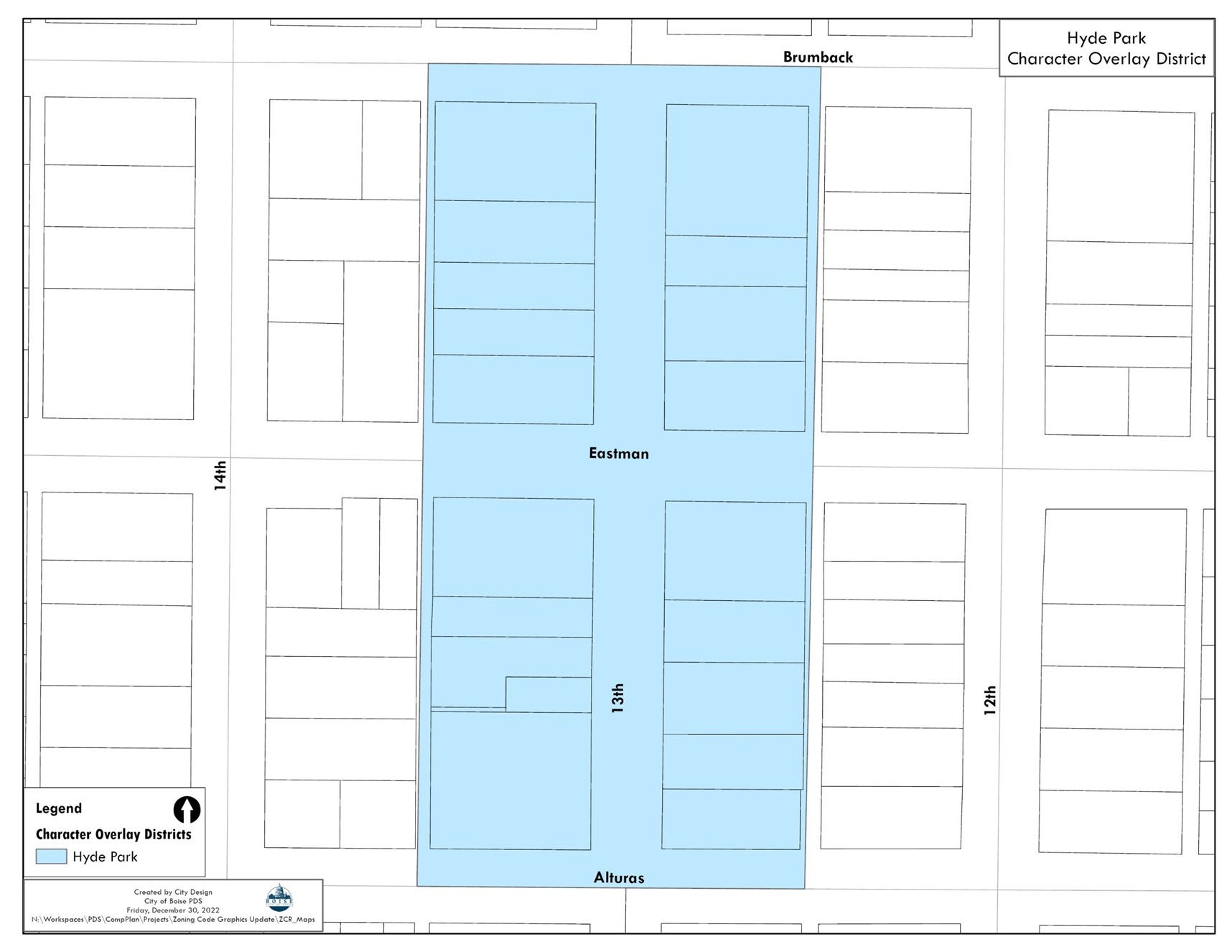
D. HC-O: Hyde Park Character Overlay:
(1) Purpose: The purpose of the HC-O District is to maintain the historical commercial district as a functioning community asset and maintain a mix of commercial, office, and residential uses. The district encourages land uses that are determined to be key to the district's long-term health and sustainability. The district regulations are intended to protect the historical and architectural character of Hyde Park and establish parking standards for this area. Parking requirements are on a graduated scale for certain uses to encourage street-level retail and restaurants as well as second story office uses. Shared parking is encouraged to reduce the need for surface parking.
(2) Boundary Map:
(3) Uses: The following uses are prohibited:
(a) Parking Garages or Park and Ride facilities; and
(b) New off-site parking lots as of March 16, 2006. On-site parking lots used as leasable off-site parking that existed prior to March 14, 2006, may continue to be used, but not expanded.
(4) District Parking Standards:
(a) Parking requirements shall follow Table 11-02.36, below.
LAND USE | GRADUATED SCALE OF USE/UNIT OF MEASURE | REQUIRED PARKING SPACES |
LAND USE | GRADUATED SCALE OF USE/UNIT OF MEASURE | REQUIRED PARKING SPACES |
Restaurant | ||
0 - 40 seats | 1 per 20 seats | |
41 - 80 seats [1] | 1 per 10 seats | |
Over 81 seats [1] | 1 per 2 seats | |
Retail | ||
0 - 750 sq. ft. | 1 | |
751 - 2000 sq. ft. [1] | 1 per 300 sq. ft. | |
Over 2001 sq. ft. [1] | 1 per 200 sq. ft. | |
Office | ||
Street level | 100 sq. ft. | |
Upper floor | 300 sq. ft. | |
Notes: [1] Parking requirements are cumulative. | ||
(b) Outdoor or seasonal seating shall be counted as regular seating and is required to meet all parking and zoning requirements in this Code. Existing outside seating shall be considered a legal nonconforming use.
(c) The allotment of parking for each business is available in the Planning and Development Services Department.
(d) Tandem parking is permitted in rear yards with alley access, provided setbacks and appropriate backup area requirements are met.
(e) All off-site parking shall have a valid contract. This contract shall state:
i. The location of the parking space(s);
ii. The contract is binding on all successors and run with the land;
iii. How the parking spaces are to be maintained and who is responsible;
iv. That the parking cannot be revoked without prior approval of the City, and shall show revocation for good cause; and
v. Provide 60 days' notice of termination to the City.
E. NC-O: Near North End Character Overlay:
(1) Purpose: The purpose of the NC-O District is to:
(a) Encourage continued residential uses;
(b) Protect the historical and architectural character of the neighborhood using adaptive reuse methods;
(c) Encourage redevelopment of sites and renovation of structures that contain established historic institutional uses;
(d) Allow for adaptive reuse of existing structures for Multiple-Family residential and established historic institutional uses;
(e) Prohibit demolition of structures for parking lots or new office developments; and
(f) Maintain the district as a transitional area between the commercial intensity of downtown and the adjacent predominantly single-family residential neighborhoods.
(2) Map and Boundaries:
(a) Boundary Map:

(3) Standards: The following restrictions and allowances beyond the requirements of the base zoning district shall apply:
(a) Parking Allowances for Adaptive Reuse in the MX-1 And R-3 Zone: Adaptive reuse of a Single-Family Detached or Single-Family Attached Dwelling for office, Multiple-Family residential, or historic institutional use may be granted the following allowances for parking requirements:
i. Tandem parking in the rear yard, with alley access, is permitted.
ii. Shared parking agreements and parking joint use agreements are required to the maximum extent practicable.
(b) Adaptive Reuse Limitation for Additions: Buildings that are adaptively reused pursuant to the provisions of this Section may be expanded in size up to 50 percent from what existed on August 21, 2001, provided:
i. The expanded portion is in keeping with the architecture of the existing building; and
ii. The site is large enough to accommodate the required number of off-street parking spaces without the granting of a Variance for setbacks or landscaping.
(c) Standards for Parking Structures and Lots in the NC-O District: On-site surface parking lots larger than 2,500 square feet are prohibited, unless incorporated within a new residential use or within and as part of the renovation, redevelopment, or expansion of an historic institutional use. As used in this paragraph, the phrase "incorporated within" shall mean located in an interior or rear yard of a development so that it is not visible from the public street.
F. BC-O: Big Sky Overlay:
(1) Purpose: The purpose of the BC-O district is to:
(a) Preserve the large lots and open character of the Big Sky Neighborhood;
(b) Retain the rural personality of this unique location; and
(c) Encourage agrarian uses through more flexible standards to maintain, protect, and enhance land use and livability.
(2) Boundary Map:

(3) Residential Standards:
(a) Setbacks:
i. New residential buildings, additions to existing residential buildings, and detached outbuildings greater than 500 square feet or 15 feet in height shall be subject to the following setback standards:
A. Front setbacks as measured from the property line shall be 35 feet minimum, 85 feet maximum, and within five feet of the average setbacks of the adjacent properties.
B. Side and rear setbacks shall be a minimum of 20 feet from the property line.
ii. Detached outbuildings with an area of up to 500 square feet and height less than 15 feet may have a reduced side and rear setbacks of 10 feet from the property line.
(b) Enclosed Garage: Dwelling units, including each unit of a Duplex Dwelling, shall have an enclosed garage with an interior dimension of at least 20 feet wide by 20 feet long.
(c) Entrances to Residential Units: Front doors of residential units shall face the street.
(d) Duplex Dwelling Standards: Duplex Dwellings in the BC-O district shall be subject to the specific design criteria as per Section 11-03-03.2.G, Dwelling, Duplex, Triplex, or Fourplex and agricultural and setback standards described in Subsection (4), below.
(a) Allowed Uses: The keeping of livestock, small animals, and similar or related agricultural uses are allowed in the BC-O district subject to the regulations of this Section.
(b) Minimum Lot Area for Large Animals: A minimum lot area of one-half acre is required for large animals as defined in this Code.
(c) Animal Reserve Area: A minimum area of one-half acre is required for the keeping and care of two animal units. Stables, paddocks, barns, and similar structures may be counted as part of the reserve area, but structures other than those related to the care of animals shall not be counted as part of the reserve area.
(d) Minimum Lot Area and Location for Small Animals: No minimum lot area is required for keeping small animals as defined in this Code. All animal units and small animals shall be kept behind the front of the principal dwelling.
(e) Animal Density Standards:
i. The maximum animal density shall be two animal units per one-half acre of reserve area. Additional reserve areas shall be added in one-half acre increments to calculate the number of animal units allowed on a particular parcel.
ii. The keeping of chickens in conjunction with the keeping of large animals is an exception to animal density standards. Up to six mature chickens may be kept simultaneously in addition to the large animals allowed per lot based on the density standard.
(f) Setbacks and Enclosures:
i. Concentrated feeding areas and buildings housing animals shall be located behind the front of the principal dwelling. Buildings for housing animals shall also comply with the setback standards for the BC-O.
ii. Livestock shall be kept within enclosures such that the livestock is prevented from encroaching on, and/or damaging, neighboring properties, fences, or vegetation or public streets. Enclosures may include but are not limited to fences, corrals, barns, and pens.
(g) Best Management Practices (BMPs):
i. Best management practices (BMPs) are intended to protect surface and ground water quality and to avoid any adverse impact to wells, irrigation ditches, and other beneficial uses. A BMP is defined as a practice or combination of practices that are the most effective, practicable means of preventing or reducing the amount of pollution generated by non-point sources to a level compatible with water quality goals. The following BMPs shall be met:
A. Fencing: Enclose one or more areas on the site with a permanent fence or structure to function as a barrier to livestock and other animals as needed in order to prevent access to and protect streams, canals, and ditches from trampling, erosion, and contamination.
B. Filter Strips for Streams, Canals, and Ditches: Maintain a gently sloping strip of ground over vegetation to filter runoff from that portion of the site occupied by animals. Filter strips shall distribute waste matter uniformly across the high end of the strip, allow waste to flow through and across the strip, and shall promote the filtering of nutrients, runoff water, and other materials through the grass in a manner so that they are absorbed by the soil and ultimately taken up by the plants.
C. Runoff Control System: Employ a combination of practices to prevent animal waste runoff to surface water and adjacent properties. Practices may include diversion of runoff from the lot, roof runoff systems, lot shaping, settling basins, and filter strips or buffer areas.
D. Liquid and Solid Waste Management System: Employ a system for managing liquid and solid waste in a manner that:
(i) Ensures fecal matter and other solid wastes do not create or promote nuisances, odors, or disease-carrying insects and animals; and
(ii) Does not degrade air, soil, or water resources. The appropriate system shall typically include the frequent spreading of liquid and solid waste, composting of manures, and off-site disposal.
ii. Additional BMPs shall be required if those listed above are shown to be ineffective. If a resident does not properly maintain or use BMPs, then the resident shall immediately cease the keeping of animals. The owner or resident can consult the following agencies for additional technical assistance:
A. Ada Soil Conservation District.
B. Natural Resources Conservation Service.
C. Idaho Soil Conversation Commission.
D. University of Idaho Extension Service.
E. Boise City Public Works Department.
G. SC-O: Sycamore Overlay:
(1) Purpose: The purpose of the SC-O district is to preserve and encourage land use and development that is consistent with the semi-rural, agricultural character and lifestyle of the Sycamore neighborhood while promoting the public health, safety, and general welfare of present and future residents of the neighborhood and Boise City.
(2) Boundary Map:

(3) Specific Standards:
(a) Setbacks: Excluding lots fronting 39th, Catalpa, and Taft Streets, the required setback for buildings and parking areas on vacant or undeveloped lots is determined by the average setback of the primary building on the two abutting lots facing the same street. The required setback shall not be less than 20 feet or greater than 40 feet. Additions to existing buildings in the SC-O district are also subject to this setback standard.
(b) Agricultural Standards: The keeping of livestock, small animals, and similar or related agricultural uses shall be subject to the generally applicable use standards of Section 11-03-03.2.J, and the standards in this Section (b). Where the standards of this Section (b) conflict with the generally applicable standards, this Section (b) shall control.
i. Allowed Uses: The keeping of livestock, small animals, and similar or related agricultural uses are allowed subject to the regulations of this Section.
ii. Minimum Lot Size: A minimum lot or parcel size of 21,780 square feet (one-half acre) is required for large animals as defined in this Code. The area of the lot or parcel used for any human dwelling shall be included when computing the one-half acre minimum lot size needed to qualify for large animals.
iii. Animal Reserve Area: A minimum animal reserve area of 10,890 square feet (one-quarter acre) is required for the keeping and care of large animals. Stables, paddocks, barns, and similar structures may be counted as part of the reserve area, but structures other than those related to the care of animals shall not be counted as part of the reserve area.
iv. Area for Small Animals: No minimum lot area is required for keeping small animals as defined in this Code, although small animals are subject to the animal density standards. All small animals as defined shall be kept behind the front of the principal dwelling.
v. Animal Density Standards:
A. The maximum animal density for large animals shall be one animal unit per one-quarter acre of reserve area. The reserve area shall be used to calculate the allowed number of large animals allowed on a particular parcel. For reserve areas larger than one-quarter acre, the one animal unit per one-quarter acre ratio shall be applied to determine the allowed number of animals. Shared reserve areas on adjacent lots may be added to the owner's reserve area to calculate the number of large animals allowed on the owner's lot.
B. The maximum animal density for small animals shall be one animal unit per one-quarter acre of land area behind the front of the principal dwelling. The area used for calculating the allowed number of small animals shall not include land occupied by any building not used for housing the animals. For areas of land different from one-quarter acre, the one animal unit per one-quarter acre ratio shall be applied to determine the allowed number of animals.
C. The keeping of chickens in conjunction with the keeping of large animals is an exception to animal density standards. Up to six chickens may be kept simultaneously and in addition to the large animals allowed per lot based on the density standard.
D. No more than one rooster shall be kept on any single parcel, regardless of the size of the parcel.
(vi) Site Plan: As deemed necessary, the Planning Director may require the owner or resident to submit a site plan, subject to approval, for the purpose of determining the amount of land available on a particular site for the keeping of animals pursuant to the standards of this Section.
(vii) Setbacks for Concentrated Feeding Areas, Buildings, and Pasture and Reserve Areas: Concentrated feeding areas and buildings housing animals shall be located behind the front of the principal dwelling and a minimum of 10 feet from all property lines. Fully enclosed buildings shall comply with the setback standards for the base zoning district and, therefore, may in some cases be set back less than 10 feet from the property line. Pasture or reserve areas shall be located behind the front of the principal dwelling and may otherwise be located at the side and rear property line.
(viii) District Perimeter Setback: Animal reserve areas for large animals shall be set back a minimum of 30 feet from any residential lot located outside the SC-O district.
(ix) Enclosures Required: Livestock shall be kept within enclosures that prevent animals from encroaching on neighboring properties or public streets. Enclosures may include, but are not limited to fences, corrals, barns, or pens.
(x) Best Management Practices (BMPs): The owner or resident shall use Best Management Practices (BMPs) to protect surface and ground water quality and to avoid any adverse impact to wells and other beneficial uses. A BMP is defined as a practice or combination of practices that are the most effective, practicable means of preventing or reducing the amount of pollution generated by non-point sources to a level compatible with water quality goals. Any owner or resident intending to keep livestock and other animals pursuant to this Section shall implement the following BMPs:
A. Fencing: Enclose one or more areas on the site as needed with a permanent fence or structure to function as a barrier to livestock and other animals to prevent access to and protect streams, canals, and ditches from trampling, erosion, and contamination.
B. Filter Strips for Streams, Canals, and Ditches: Maintain a gently sloping strip of ground cover vegetation to filter runoff from the portion of the site occupied by animals. Filter strips shall distribute waste matter uniformly across the high end of the strip and allow waste to flow through and across the strip and shall promote the filtering of nutrients, runoff water, and other material through the grass so that they can be absorbed by the soil and ultimately taken up by the plants.
C. Runoff Control System: Employ a combination of practices to prevent animal waste runoff to surface water and adjacent properties. Practices may include diversion of runoff from the lot, roof runoff systems, lot shaping, settling basins, and filter strips or buffer areas.
D. Liquid and Solid Waste Management System: Employ a system for managing liquid and solid waste in a manner that: a) ensures fecal matter and other solid wastes do not create or promote nuisances, odors, and disease-carrying insects or animals, and b) does not degrade air, soil, or water resources. The appropriate system shall typically include the frequent spreading of liquid and solid waste, composting of manures, and off-site disposal.
(xi) Additional BMPs: Additional BMPs shall be required if those BMPs listed above are shown to be ineffective. The owner or resident can consult the following agencies for additional technical assistance:
A. Ada Soil Conservation District Natural Resources Conservation Service.
B. Idaho Soil Conservation Commission.
C. The University of Idaho Extension Service.
D. Boise Public Works Department.
(xii) Periodic Assessment: At three year intervals, the residents and property owners in the SC-O district and the Planning Director shall assess the impact and effectiveness of the standards of this Section in protecting residents and owners of the district and those outside the district from unwanted impacts.
2. Design Review Overlay Districts:
A. Purpose: Design review overly districts are intended to maintain the unique design qualities of specific areas. A design review overlay district is usually applied to residential neighborhoods with certain identifiable design features or attributes embodied in architecture, urban design, or history.
B. Designation of Design Review Overlay Districts:
(1) Design review overlay districts shall be designated by ordinance. Neighborhoods or areas selected for consideration for a design review overlay district designation shall meet at least one of the following criteria:
(a) Has distinctive design character with identifiable attributes embodied in architecture, urban design development patterns, or history that make it a unique and integral part of the city's design identity; or
(b) Has a recognized neighborhood design identity and a definable design or historical character that has a high design value or a relationship to urban centers or significant areas of the city that makes the area's conservation significant to the city's history or function.
(2) Design review overlay district provisions may apply additional requirements or allow exceptions to the standard regulations of the base zoning district.
(3) Prior to recommending an area for designation as a design review overlay district initiated by the Planning Director, the Planning and Zoning Commission shall:
(a) Conduct any necessary plans, studies, research, or investigations;
(b) Assess neighborhood and landowner support; and
(c) Prepare a report containing recommendations.
(4) Prior to adoption of a design review overlay district ordinance in a district that may be of historic significance as determined by the Planning Director, the Historic Preservation Commission shall have the opportunity to review and comment on the proposed ordinance.
D. CD-O: Capitol Boulevard Design Overlay:
(1) Purpose: The purpose of the CD-O district is to recognize the importance of Capitol Boulevard and to maintain and enhance its special character. The intent of these provisions is to protect Capitol Boulevard as one of the principal gateway streets in the State of Idaho and to visually link two of the most important historic buildings in the city - the State Capitol and the Boise Depot. The CD-O provisions also are intended to ensure consistent streetscape design along the Boulevard and protect a variety of uses that are of importance to the community, including cultural centers and parks, Boise State University, hotels, retail establishments, and restaurants.
(2) Boundary Map:

(3) District Subareas: The District is divided into four areas:
(a) Downtown Corridor: Both sides of Capitol Boulevard from the centerline of Front Street north to the centerline of State Street.
(b) Central Corridor: Both sides of Capitol Boulevard from centerline of Front Street south to the Boise River.
(c) Entrance Corridor: East side of Capitol Boulevard from the Boise River to the Depot.
(d) Exit Corridor: West side of 9th Street and Capitol Boulevard from the Boise River south to the Depot.
(e) Subareas Boundary Map:

(a) Increase in building size by 10 percent;
(b) Replacement of more than 25 percent of a building;
(c) Any new building; or
(d) A façade remodel that uses different materials and design features (a color change or the addition of non-permanent features such as fabric awnings are not subject to Design Review).
(5) Standards:
(a) Streetscape Requirements: Streetscape improvements for Capitol Boulevard shall comply with the adopted Capitol Boulevard Plan and Action Program.
i. Applicability: The streetscape improvements shall be required and shown on the development plans when:
A. Constructing a new building or parking lot; or
B. Constructing an addition greater than 30 percent of the original square footage of the building, provided the addition is greater than 2,500 square feet gross floor area.
ii. Standards:
A. Downtown Corridor: For each section of the Corridor, required improvements include, but are not limited to:
(i) Brick streetscape shall remain along the west side of Capitol Boulevard from Bannock Street to Front Street.
(ii) Streetscape upgrades consistent with the "Urban Sidewalk - Brick" prototype in the Capitol Boulevard Plan and Action Program along the east side of Capitol Boulevard from Bannock Street to Front Street.
(iii) 10 foot wide detached sidewalk and nine foot wide landscape strip adjacent to the street with street trees, shrubs, and historic street lights along both sides of Capitol Boulevard from Bannock Street to Jefferson Street.
B. Central Corridor: For each section of the Corridor, required improvements include, but are not limited to:
(i) Relocated curb to form a 52 foot wide road Section measured curb to curb.
(ii) Sidewalks with pavers.
(iii) Planters with street trees, shrubs, and low steel fencing, as shown in the Capitol Boulevard Plan and Action Program.
(iv) Furnishing zone with historic street lights, as shown in the Capitol Boulevard Plan and Action Program.
(v) Benches, litter receptacles, movable planters, bicycle racks, and newsstands, as shown in the Capitol Boulevard Plan and Action Program.
(vi) Kiosks, public art, and transit stops may be considered.
C. Entrance And Exit Corridors: For each section of the Corridor, required improvements include, but are not limited to:
(i) 12 foot wide concrete multiuse pathway.
(ii) Eight to 10 foot wide landscape strips with lawn and street trees.
(iii) A second row of deciduous trees.
(iv) Historic street lights.
(v) Bus stop shelters at select locations.
(b) Building and Structure Setbacks:
i. Downtown Corridor: The setbacks of the underlying zoning district shall apply, except a 25 foot setback from the property line is required along Capitol Boulevard for any portion of a structure that is 45 feet or higher.
ii. Central Corridor: Minimum setbacks shall be as follows:
A. 45 feet from the centerline of Capitol Boulevard for structures up to 45 feet in height.
B. 75 feet from the centerline of Capitol Boulevard for any portion of a structure that is higher than 45 feet.
C. Only approved awnings, canopies, or similar projections may encroach into the public right-of-way.
iii. Entrance And Exit Corridors: Minimum setbacks shall be as follows:
A. 20 feet from the property line along Capitol Boulevard for structures less than 45 feet in height.
B. 35 feet from the property line along Capitol Boulevard for any portion of a structure that is higher than 45 feet.
iv. Required Improvements Within Entrance and Exit Corridor Setback Areas: At-grade setback areas shall include landscaping, and one or more of the following:
A. An extension of the streetscape, such as a pedestrian space or a plaza utilizing benches, pavers, and other design elements;
B. Sculptures, public art, or architectural design features;
C. Canopies and other external decorative features, provided they do not encroach more than 30 percent into the setback;
D. Sign(s); and
E. Low decorative masonry walls of three feet or less (see also Section 11-04-09, Landscaping, Fencing, Walls, and Screening.
(c) Parking Lot Setbacks and Requirements:
i. Parking Lots: Parking lots shall be located below or behind buildings facing Capitol Boulevard.
ii. Parking Lot Screening: Parking lots shall be screened using one or more of the following, unless otherwise approved by the Design Review Commission (DRC).
A. Decorative masonry screen walls that may include wrought iron fencing. The maximum length without modulation shall not exceed 30 feet.
B. Landscaping plantings that provide year-round screening.
(d) Building Design: Buildings shall be designed to the highest standards with consideration of the following:
i. All building façade materials should be of high quality to enhance the appearance of Capitol Boulevard including, but not limited to stone, brick, or tile. The same façade materials or other architecturally compatible façade materials should be used for all exposed walls on all sides of the building and other architectural features.
ii. Architectural style is not to be restricted; however, the appearance of the building shall be reviewed based on the use of materials and color, the quality of design, use of architectural details, and the scale, mass, and bulk with the overall Capitol Boulevard development.
iii. Blank walls or faux windows facing Capitol Boulevard are not allowed.
iv. Buildings located on corner sites that can be viewed from Capitol Boulevard should be given significance through the use of architectural elements, special materials, height, and/or entrance doors.
v. Distinctive roof or other termination of the building façade.
vi. Windows, doors, eaves, and parapets should be proportional to one another.
vii. New buildings and any modifications to historic buildings shall comply with the Design Guidelines for Boise City's Historic Commercial Districts and the Secretary of the Interior Guidelines.
viii. Canopies and awnings at street level should not be illuminated and should be functional for purposes of pedestrian use.
ix. Mechanical equipment should be well screened from public right-of-way with materials that are harmonious to the building's exterior materials.
x. Utilities shall be installed underground, except for transportation facilities.
(e) Lighting: Pedestrian and landscape lighting is encouraged and street lighting shall conform to the Capitol Boulevard Streetscape Master Plan.
(f) Vehicular Access:
i. Curb cuts shall be limited to the minimum width and number needed for safe vehicular access and pedestrian and bicycle crossings.
ii. Access points shall be defined with landscaping or other decorative elements.
(g) Restrictions Along Capitol Boulevard: The following shall not front on to Capitol Boulevard:
i. Off-street service and loading areas;
ii. Trash dumpsters;
iii. Outdoor storage areas;
iv. Fuel pumps;
v. Drive-up windows; and
vi. Surface parking lots fronting on the street.
(h) Signage: Sign standards for the CD-O district shall be as indicated in Section 11-04-012, Signs.
E. HD-O: Historic Design Overlay:
(1) Purpose: The purpose of the HD-O is to promote the educational, cultural, and economic welfare of the public by engaging in a comprehensive program of historic preservation to promote, preserve, and protect historic buildings, structures, sites, monuments, streets, squares, and neighborhoods that serve as visible reminders of the historical, archeological, architectural, educational, and cultural heritage of the city. It is the further purpose of this Section for the social, economic, and environmental advantages of the city to promote the use and conservation of such property and to encourage new buildings and developments that will be harmonious with the existing historical, archeological, architectural, educational, and cultural buildings, structures, sites, streets, squares, and neighborhoods.
(a) Historical or Cultural Importance:
i. Has significant character, interest, or value, as part of the development, heritage, or cultural characteristics of the city, state, or nation;
ii. Is associated with the life of a person significant in the past;
iii. Is the site of an historic event with a significant effect upon society;
iv. Exemplifies the cultural, political, economic, social, educational, or historic heritage of the community;
v. By being part of or related to a street, square, park, or other distinctive area, should be developed or preserved according to a plan based on historic, cultural, or architectural motif; or
vi. Owing to its unique location or singular physical characteristic, represents an established and familiar visual feature of the neighborhood, community, or city.
(b) Architectural Importance:
i. Portrays the environment in an era of history characterized by a distinctive architectural style;
ii. Embodies those distinguishing characteristics of an architectural-type or engineering specimen;
iii. Is the work of a designer, architect, or craftsman whose individual work has significantly influenced the development of the city, state, or nation; or
iv. Contains elements of design, detail, materials, or craftsmanship that represent a significant innovation.
(c) Archeological Importance:
i. Has yielded or may be likely to yield, information important in pre-history or history; or
ii. Contains or is likely to contain physical remains, such as fossils, relics, monuments, art, or symbols, of past human life and activities.
(4) State Property: Nothing in this Section 11-02-07.2.E or related to historic preservation or designation shall be construed to allow the designation, regulation conditioning, restriction or acquisition of historic buildings, structures, sites or areas, or other properties or facilities owned by the state or any of its political subdivisions, agencies, or instrumentalities.
(5) Acquisition of Historic Property: All lands, buildings, structures, sites, or areas acquired by funds appropriated by the City shall be acquired in the name of the City unless otherwise provided by the governing board. So long as owned by the City, historic properties may be maintained by or under the supervision and control of the City.
(6) Acquisition of Historic Easements:
(a) The City may acquire, by purchase or donation, historic easements in any area within the jurisdiction of the city wherever and to the extent City Council determines that the acquisition will be in the public interest.
(b) The City Council shall seek a recommendation from the Historic Preservation Commission regarding the historic easement and proposed resolution.
(7) Ordinary Repairs - Public Safety: Nothing in this Section 11-02-07.2.E or related to historic preservation or designation shall be construed to prevent the ordinary maintenance or repair of any exterior feature in an Historic District, or of any Historic Landmark that does not involve a change in design, material or outer appearance thereof, nor to prevent the construction, reconstruction, alteration, restoration or demolition of any such feature when the Building Official shall certify such is required for the public safety because of an unsafe or dangerous condition.
(8) Maintenance and Repair Required - Demolition by Neglect:
(a) Any property located within an Historic District or Residential Historic District or designated as an Historic Landmark shall be preserved by the owner, or such other person or persons as may have the legal custody or control of the property, against decay and deterioration and free from unreasonable structural defects. The owner or other person having legal custody and control of the property shall repair such resource if it is found to have one or more of the following defects, or other defects that in the judgment of the Historic Preservation Commission has a detrimental effect on the historical characteristics of the property or district.
i. The deterioration of exterior walls or other vertical supports;
ii. The deterioration of roofs or other horizontal members;
iii. The deterioration of exterior chimneys;
iv. The deterioration or removal of exterior finishes or fenestration;
v. The ineffective waterproofing of exterior walls, roofs and foundations including broken windows or doors; and
vi. The deterioration of any feature so as to create or permit the creation of any hazardous or unsafe condition or conditions.
(b) If the Historic Preservation Commission (HPC) makes a preliminary determination that a resource is being demolished by neglect, it shall direct the Building Official to notify the owner(s) of the resource of this preliminary determination, stating the reasons therefore, and shall give the owner of record 28 days from the date of mailing of such notice to commence work to correct the specific defects as determined by the HPC.
(c) If the owner(s) fail to commence work within the time allotted as evidenced by a Building Permit, the Historic Preservation Commission (HPC) shall notify the owner(s) in writing to appear at a public hearing before the HPC at a date, time, and place to be specified in the notice, which shall be mailed at least 28 days before the hearing. The HPC shall also notify in writing adjacent property owners and the Registered Neighborhood Association of such hearing. The HPC shall receive evidence on the issue of whether the subject resource should be repaired and the owner(s) may present evidence in rebuttal thereto. If, after such hearing, the HPC determines that the resource is being demolished by neglect, it may direct the City Attorney to commence legal action against the owner(s) if the necessary repairs are not completed within 90 days or a time frame as specified by the HPC.
(9) Exemption from Fire or Building Codes: The City Council, in order to promote the preservation and restoration of any Historic Landmark, or property within an Historic District may, upon the recommendation of the Historic Preservation Commission, exempt an Historic Landmark or property within an Historic District from the application of the City Fire or Building Codes upon compliance with the criteria for exemption set forth in the Codes and upon a finding that non- exemption would prevent or seriously hinder the preservation or restoration of the Historic Landmark or property in an Historic District. Upon rescission of an historic designation, any Code exemption herein granted shall be revoked effective the date of rescission.
(10) Notice of City Departments and Other Agencies: In addition to all other transmittals and notices required by this Section 11-02-07.2.E, within seven calendar days after the designation by ordinance of any Historic District or Landmark, the Historic Preservation Commission shall notify all departments of the city and other governmental agencies having a regulatory or legally prescribed duty affecting such District or Landmark. The notice shall state the fact of such designation, identify the boundary of the District, or the address of the Landmark, and shall summarize the effect such designation will have.
(11) Register of Historic Districts and Landmarks: A current register and map of all Historic Districts and Landmarks that have been designated by ordinance shall be made available upon request from the Planning and Development Services Department or on the City's website. Such register and map shall be made public and available to the City departments, other governmental agencies, and any interested person.
3. Sensitive Lands Overlay Districts:
A. Purpose: Sensitive lands overlay districts are intended to protect unique environmental features and systems within the city from the impacts of development, or to protect public health and safety by including additional restrictions on development in or near areas where necessary and permitted activities may create additional risks to the public.
B. Designation of Sensitive Lands Overlay Districts:
(1) Sensitive lands overlay districts shall be designated by ordinance. Areas selected for consideration for a sensitive lands overlay district designation shall meet at least one of the following criteria:
(a) Includes sensitive environmental areas or systems or portions of systems that need additional protection from the impacts of development in order to retain healthy environmental functions or to protect a unique environmental feature within the city; or
(b) Includes lands in or around an area where needed and permitted activities may create additional risks to public health and safety unless additional restrictions on the location and type of development or permitted human occupancy of those lands is subject to additional regulations.
(2) Sensitive lands overlay district provisions may apply additional requirements or allow exceptions to the standard regulations of the base zoning district.
(3) Prior to recommending an area for designation as a sensitive lands overlay district initiated by the Planning Director, the Planning and Zoning Commission shall:
(a) Conduct any necessary plans, studies, research, or investigations; and
(b) Prepare a report containing recommendations.
D. AI-O Airport Influence Area Overlay:
(1) Purpose: The purpose of the AI-O district is to:
(a) Promote development that is compatible with and protects the safe operation of the airport;
(b) Ensure all development is compatible with the noise levels from operations at the airport;
(c) Ensure future development within the Airport Influence Area is designed in accordance with the Airport Master Plan; and
(d) Ensure compliance with applicable federal regulations and guidance.
(2) Boundary Map:

(3) Design Standards: All new development and existing structures within the Airport Influence Areas shall comply with the following:
(a) All new residential development and new Schools in the Airport Influence Area A are required to provide insulation to achieve a noise level reduction of 25 decibels.
(b) Residential development or other noise sensitive development such as Schools, Universities, Religious Institutions, or Adult or Child Day Care Facilities are prohibited within the Airport Influence Area B. All compatible uses are required to provide insulation to achieve a noise level reduction of 35 decibels within the noise sensitive areas of a facility.
(c) New residential development within Airport Influence Area B-1 is required to provide insulation to achieve a noise level reduction of 30 decibels. For new residential development or redevelopment of an existing site, the maximum density within the Airport Influence Area B-1 is five residential units per acre with additional density being considered on a case-by-case basis pursuant to Section 11-05-05.3.C, Conditional Use Permit - Initial Approval or Major Expansion.
(d) Schools, Universities, Religious Institutions, and Adult or Child Day Care Facilities are prohibited within the Airport Influence Area B-1. Commercial uses are compatible but are required to provide insulation to achieve a noise level reduction of 25 decibels within noise sensitive areas of a facility.
(e) Existing residential uses in the Airport Influence Area C are considered legally nonconforming. New residential uses in this area are prohibited. Non-noise sensitive manufacturing, industrial and commercial uses are allowed but are required to provide insulation in noise sensitive areas of a facility.
(f) All approved developments in the Airport Influence Areas are required to grant the airport an avigation easement in a form acceptable to the City Attorney. Sample avigation easements are available on the airport website.
E. BR-O: Boise River System Overlay:
(1) Purpose: The purpose of the BR-O district is to:
(a) Ensure protection from flooding;
(b) Allow for conveyance of the 100 year flood flow to lessen damage to public and private properties;
(c) Preserve, protect, and enhance the abundance and diversity of fish, wildlife, and riparian vegetation native to the Lower Boise River and its floodplain, and that of its tributaries;
(d) Control runoff and pollution so as to protect water quality of the river and its tributaries;
(e) Protect the Boise River as a public asset to the city and a major amenity for its citizens;
(f) Maintain the Boise River Greenbelt;
(g) Ensure that development is designed to enhance and protect rivers including riparian areas, fish, wildlife, and recreational values; and
(h) Provide and maintain continuous public access to and along the river including appropriate facilities for parking of bikes and motor vehicles.
(2) Applicability: The following standards and regulations of uses within the district apply:
LANDS AND WATERS CLASSIFICATION | FLOODPLAIN REGULATIONS | ||||
Class A | Yes | Yes | Yes | Yes | Yes |
Class B | Yes | Yes | Yes | Yes | Yes |
Class C | Yes | Yes | No | Yes | Yes |
(3) Map and Boundaries:
(a) Boundary Map: A boundary map can be found on the City's website.
(b) Districts: The Boise River System Overlay district shall include the following areas:
i. Floodway and Floodway Fringe Overlay Districts: Lands within the 100 year floodplain boundaries adjacent to the Boise River, including lands designated within the Floodway (F) and Floodway Fringe (FF). These boundaries adjacent to the Boise River are determined by the FEMA Flood Boundary and Floodway Map. A copy of this map is available at the Planning and Development Services Department and on the City's website. The Planning Director, with recommendation from the City Engineer, shall provide boundary interpretations where necessary. These areas are subject to the standards in Section 11-02-07.3.F FP-O Flood Protection Overlay and the standards in Subsections (4) - (10), below.
ii. Alluvial Overlay District: Tributary floodplains and associated alluvial fans (AO zones) standards are addressed in Section 11-02-07.3.F, FP-O Flood Protection Overlay.
(4) Boundary Descriptions:
(a) Floodway (F) District Boundary: The Floodway District shall have the boundaries as follows: The Channel of a river or other watercourse and the adjacent land areas that shall be reserved in order to discharge the base flood without cumulatively increasing the water surface elevation more than one foot, as shown in the Flood Insurance Study for Boise City, Idaho.
(b) Flood Fringe (FF) District Boundary: The Floodway Fringe District shall have boundaries as follows: The area between the floodway boundary and the boundary of the 100 Year Flood.
(c) Area of Shallow Flooding (ASF) District Boundary Description: The Area of Shallow Flooding District shall have boundaries as area shown on the Flood Insurance Rate Map as an AO zone with base flood depths from one to three feet where a clearly defined channel does not exist, where the path of flooding is unpredictable and indeterminate, and where velocity flow may be evident.
(5) A, B, And C Lands and Waters Classifications: The BR-O district includes lands and waters that provide natural resource functions and values including the preservation of fish and wildlife amenities shall be classified as "Class A, B, or C lands and waters."
(a) Class A, B, And C Lands and Waters Established:
i. A set of master maps delineating class A, B, and C lands and waters is located in the Planning and Development Services Department or on the City's website. The precise boundaries shall be determined based on available maps, studies, outside agency input and on-site inspections.
ii. The Boise River Fish and Wildlife Habitat Study, (Sather-Blair, et al, 1983), shall be used as a reference that provides objectives for preservation and management actions for Class A and Class B areas. A copy of this study is available at the Planning and Development Services Department and on the City's website.
(b) Class A Lands and Waters - Extremely Important for Preservation: Class A lands and waters provide extremely important habitats for fish and wildlife and for flood control and protection. The objective is to preserve and protect these areas for their benefits to fish and wildlife in general and to protect Bald Eagle, Great Blue Heron, trout, and waterfowl habitats in particular. These areas include, but are not limited to:
i. Floodways;
ii. Areas with a high degree of plant community diversity;
iii. Black cottonwood riparian plant communities;
iv. Riparian forests;
v. Scrub-shrub wetlands;
vi. Emergent wetlands within the floodplain (exclusive of working irrigation canals);
vii. A 300 foot radius around Great Blue Heron rookeries;
viii. Eagle winter habitat that includes lands within 200 feet of the 6500 cubic feet per second (c.f.s.) line, as determined by the Public Works Department based on their monitoring of annual flows, east of Walnut Street on the north side of the river and east of Phase 4 of the River Run Subdivision on the south, and forested wetlands east of these points;
ix. Lands within the riparian setback lands and waters;
x. The banks of side channels and tributary stream areas within the jurisdiction of this overlay district;
xi. Islands within the river;
xii. Trout spawning waters;
xiii. Riparian areas of tributary streams within the jurisdiction of this overlay district including channels that convey floodwaters and areas that meet the definition of wetlands; and
xiv. Lands currently identified as the Barber Pool Conservation Area.
(c) Class B Lands and Waters - Moderately Important for Preservation: Class B lands and waters provide good potential for improvements to natural resource functions and values. Development should improve natural resource functions and values and avoid negative impacts. Class B lands and waters include, but are not limited to:
i. Agricultural lands;
ii. Gravel pit ponds and small lakes; and
iii. Intermittent tributary streams.
(d) Class C Lands and Waters - Least Important for Preservation: Class C lands and waters provide limited fish and wildlife habitat. Development should provide landscaping and habitat improvements. These areas include, but are not limited to:
i. Public and private parks where current uses preclude enhancement of fish and wildlife habitat;
ii. Diversion dams;
iii. Residential and commercial developments;
iv. Lands surrounding gravel ponds;
v. Subdivided properties;
vi. Former industrial areas; and
vii. Vacant lands in urban centers.
(6) Setbacks: Setbacks are intended to protect and preserve the river, Greenbelt, Great Blue Heron rookeries, eagle perching, feeding, and loafing areas, and riparian areas.
(a) Boise River Setback: The setback for structures and parking areas is 70 feet from the 6500 c.f.s. line of the Boise River or five feet from the boundary of all dedications or easements granted to the City for Greenbelt purposes in excess of 65 feet.
(b) Greenbelt Setback: The Greenbelt setback for structures and parking areas is 70 feet measured landward from the 6500 c.f.s. setback line.
(c) Great Blue Heron Rookeries Setback: The setback for structures and parking areas is 300 feet from the 6500 c.f.s. around Great Blue Heron rookeries. Rookeries shall be designated by the City and the Idaho Fish and Game Department.
(d) Eagle Perching, Feeding, and Loafing Setback: The setback for structures and parking areas is 200 feet from the 6500 c.f.s, east of Walnut Street along the north side of the Boise River, and east of Phase 4 of the River Run subdivision along the south side of the Boise River.
(e) Riparian Setback:
i. Tier 1 Waterway: A side channel with a width of less than 15 feet, measured from the top of bank, or with a flow of less than five c.f.s. shall have a riparian setback of 20 feet.
ii. Tier 2 Waterway: A side channel at least 15 feet wide, measured from top of bank, or with a flow of between five to 150 c.f.s. shall have a riparian setback of 25 feet.
iii. Structure Setback: A minimum of 15 feet shall be maintained between the riparian setback and structures.
(7) Allowed Uses and Improvements: The following uses and improvements are allowed in Class A lands and waters areas subject to the standards for uses, mitigation and enhancement provisions set forth in this Section 11-02-07.3.E.
(a) All uses not explicitly listed below are prohibited in Class A lands and waters areas.
i. Signs (non-commercial);
ii. Existing restrooms and snack bars;
iii. River bridges and paved access to river bridges;
iv. Fish and wildlife habitat improvements;
v. Irrigation weirs, diversion dams, and inlets;
vi. Water inlets to supply domestic water;
vii. Greenbelt structures under existing bridges;
viii. Greenbelt paths or non-paved pedestrian paths that may provide limited access to the river and may run into or through lands designated as Class A habitat areas;
ix. Paved paths limited to:
(A) Existing or expansions of public pathways;
(B) The Lander Street sewage treatment plant path;
(C) The Warm Springs Park area pedestrian path and bridge; and
(D) Where an existing railroad right-of-way is already located or other new areas that may be used as a multi-use public pathway;
x. Natural parks;
xi. Bank and channel stabilization projects;
xii. Hydro-electric and flood protection dams;
xiii. Selected public piers and beaches;
xiv. Public utility lines such as water and sewer lines;
xv. Storm drain outlets and detention basins;
xvi. Water pump facilities;
xvii. Gravel extraction including reuse of gravel extraction lands; and
xviii. One dwelling unit per 20 acres or legal nonconforming lot.
(b) Uses allowed in Class B and Class C areas are limited to those listed in Table 11-03.1: Table of Allowed Uses.
(8) Standards:
(a) Standards Applicable to All Development Within the BR-O District
i. Emergent Wetlands: In recognition of their importance and their scarcity, emergent wetlands shall be preserved as follows:
A. Emergent wetlands surrounded by Class B or Class C lands may be replaced with a wetland of equal size, provided that the created emergent wetland has the same or greater degree of natural resource functions and values as did the impacted emergent wetland.
B. The emergent wetland may be relocated anywhere on the project site, except within Class C lands.
C. If the emergent wetland is relocated to a site within existing Class A lands, then the land area of Class A lands and waters shall be enlarged by an amount no less than the size of the impacted emergent wetland.
ii. Enhancement of Water Resources: Proposals to use or create a water amenity shall be designed to accommodate wetland and riparian functions and waterfowl, wildlife, trout, or warm water fish habitats.
iii. Parks and Open Spaces:
A. Park areas where sporting events take place shall be located outside of Class A lands.
B. Open spaces such as parks, golf courses, greenbelt areas, or parking lots, within the floodplain shall be designed and operated to flood and provide storage capacity during flood flows in excess of 6500 c.f.s.
iv. Emergency Access: New developments shall include provisions for emergency access to the Boise River and Greenbelt as determined by the Boise Fire Department.
v. Greenbelt Access: Developments shall provide for public access to the Boise River Greenbelt and public parking for bicycles and motor vehicles.
vi. Landscaping: Landscaping shall use native or naturalized plant materials that provide wildlife food and shelter for wildlife. Manicured landscaping and lawns are prohibited in Class A lands and in riparian areas and setbacks.
vii. Bank and Channel: Bank or channel stabilization measures (e.g., rip-rap, drop structures, large cobble) shall include over-planting with shrubs and trees for the deliberate enhancement of fish habitat.
viii. Screening Requirements:
A. Structures shall be screened from view from the Greenbelt and the river with landscaping that will grow to a height of at least 20 feet within 10 years.
B. Parking areas located between a structure and the Boise River shall be screened from view by landscaping or decorative fencing at least five feet in height.
C. Appropriate landscaping should be used to screen habitat areas from new development.
ix. Construction Fencing: Fencing shall be installed where construction activities abut a riparian area.
(b) Additional Standards Applicable to Class A Lands and Waters:
i. Class A areas within a development or subdivision shall be preserved in single common ownership through a conservation easement or other method approved by the City.
ii. The removal of living or dead vegetation from the floodway shall not be permitted unless:
A. The vegetation poses a threat to persons or property;
B. The vegetation contributes to a dangerous restriction of the flow of floodwater; or
C. The removal of vegetation is part of an approved mitigation and enhancement plan.
iii. Removal of vegetation shall be confined to the minimum necessary, while still maintaining the natural riparian areas. Removal of vegetation is subject to approval by the Planning Director after review and recommendation by the Urban Forestry Division of the Boise Parks and Recreation Department.
iv. Emergency situations under ii and iii above may require actions to be taken before the Planning Director can be contacted. If that is the case, then the action taken shall be reported to the Planning Director and mitigation efforts shall be taken if the Planning Director requires them.
(c) Additional Standard Applicable to Class B Lands and Waters: Development shall improve natural resource functions and values and shall mitigate negative impacts.
(d) Additional Standard Applicable to Class C Lands: Development plans shall provide for habitat improvements and landscaping to create screens and buffer between wildlife habitat areas and new.
(9) Conditions for Permits: Conditions may be attached that:
(a) Require compliance with applicable specifications, standards or requirements of the Idaho Department of Water Resources, Army Corps of Engineers, the Idaho Fish and Game Department, U.S. Fish and Wildlife Service, Environmental Protection Agency, the city, or other agencies.
(c) Require landscaping consistent with the objectives of the Greenbelt or the extension of the natural setting of the river.
(d) Limit reclamation of eroded stream banks in the floodway and require overflow channels to remain open.
(e) Limit construction to certain periods of time.
(f) Require certification by a licensed engineer that conditions have been fulfilled.
(10) Mitigation:
(a) Purpose:
i. The purpose of this Subsection (10) is to offset negative impacts of a proposed development on the natural resource functions and values in Class A and B lands and waters.
ii. Mitigation goals for Class A and B lands shall be no net loss of existing natural resource functions and values associated with flood protection, fish and wildlife habitat, recreation and other goals of the Comprehensive Plan and Boise River Plan.
(b) Natural Resource Functions and Values: Natural resource functions and values are:
i. Water quality;
ii. Habitat for fish and wildlife;
iii. Nutrient retention and removal;
iv. Channel stability;
v. Food chain support;
vi. Flood storage and de-synchronization;
vii. Groundwater recharge and discharge;
viii. Recreation;
ix. Aesthetics; and
x. Cultural resources.
(c) Mitigation Measures and Sequencing for Class A, B, and C Lands and Waters: The mitigation sequence shall be examined in the order listed below. Several mitigation measures may be used in combination to provide the greatest protection to the resource. Different mitigation sequencing may be used provided extensive evidence is submitted and adequately demonstrates the impacts and public benefits available. The burden shall be on the applicant to demonstrate compliance with the minimum standards described in this Section.
i. Mitigation Measures for Class A and B Lands and Waters: Mitigation measures from the most to the least preferable are:
A. Avoid adverse impacts by selecting alternative alignments or locations.
B. Minimize impacts by limiting encroachments, using less intrusive construction techniques, or other methods.
C. Restore the impact area to as near its original condition as possible.
D. In-kind on-site compensation.
E. In-kind off-site compensation.
ii. Mitigation Measures for Class C Lands and Waters: Mitigation is not required. Development in Class C lands shall not adversely affect adjacent and nearby habitat in Class A or Class B lands.
(d) Procedures for Development of Mitigation Plan:
i. Generation of Field Data: To accurately describe existing conditions, constraints, and their magnitude, existing natural resource functions and values shall be assessed by the applicant. This assessment shall be provided with the project application for review by the city along with a comprehensive technical plan to mitigate impacts to natural resource functions and values, or to enhance natural resource functions and values.
ii. Early Coordination with Resource and Regulatory Agencies: Consultation with government agencies that have resource responsibilities shall be initiated by the applicant as soon as practicable to determine the natural resource functions and values existing within the area requiring a River System Permit. Consultation shall also include a discussion of the presence of threatened and endangered species, and species of special concern; fish and wildlife habitat requirements and their sensitivity to disturbance; and measures needed to mitigate for project related impacts or to enhance existing habitat. Consultation shall be documented.
iii. Comprehensive Mitigation Design: Proposed modifications to Class A and B lands and waters shall include:
A. Preliminary Mitigation Plan: A preliminary site plan shall identify the location and quality of existing natural resources, impacts to those resources attributable to the proposed project, and proposed mitigation measures.
B. Final Mitigation Plan:
(i) Upon approval of the River System Permit a final site plan shall be developed by the applicant that includes a detailed description, plan view, profile, and typical Sections of the mitigation project. The final site plan shall fully describe proposed changes to the resource and the materials and methods used to accomplish mitigation.
(ii) The final site plan may be offered to the state and federal agencies for review. Comments of these agencies shall be fully considered by the City in its determination of whether the final site plan is in accordance with the River System Permit.
iv. Performance Monitoring: The applicant shall monitor the performance of constructed mitigation improvements for a minimum period of 18 months unless otherwise fixed by the Planning and Zoning Commission. Acceptable performance shall be judged by comparing measured values to previously agreed upon standards.
(11) Enhancement:
(a) Purpose: The purpose of this Subsection (11) is to encourage innovative development design to increase the quantity and improve the quality of existing natural resource functions and values.
(b) Enhancement Plans: Enhancement plans may be submitted but are not required as part of an application for a River System Permit.
(c) Enhancement Design Standards:
i. Enhancement of Class A, B, And C Waters:
A. Enhancement of Waters Held by the Idaho Department of Fish and Game: Enhancement or creation of water amenities that use waters held by Idaho Department of Fish and Game shall be designed for the propagation and perpetuation of fish and wildlife resources.
B. Enhancement of Non-Idaho Department of Fish and Game Waters: Enhancement or creation of water amenities not held by Idaho Department of Fish and Game may be designed to enhance fish and wildlife resources or to provide a visual amenity.
ii. Enhancement of Class A, B, and C Passive Open Space:
A. Class A Passive Lands: Class A passive open space shall be designed with the primary intent of providing enhancement to fish, wildlife and riparian resources with specific design or attention given to eagles, Great Blue Heron, trout, and waterfowl. Vegetation shall be predominantly native or naturalized plant species.
B. Class B and C Passive Open Space: Class B and C passive open space should be designed to encourage the creation of fish, wildlife, and riparian resources and to create transition between natural areas and areas of more intense development. Vegetation may be a combination of native or naturalized vegetation and ornamental or exotic species.
C. Native and Naturalized Vegetation: Native and naturalized vegetation should be located near established or created habitat areas and may transition to more ornamental species towards or within the development.
D. Adjustment of Standards:
(i) In order to provide an incentive for higher quality and more extensive enhancement plans, adjustments of zoning and subdivision standards may be requested.
(ii) Adjustments may be granted by the Planning and Zoning Commission or City Council on enhancement plans that have been designed in accordance with this Section and in compliance with the BR-O district.
(iii) An adjustment of the standards may be approved when evidence presented meets the following conclusions of law: (1) that the proposed enhancement plan is in compliance with the applicable standards of Section 11-02-07.3.E(10), (2) that the proposed enhancement plan complies with all local, state, and federal laws and regulations, and (3) that the adjustments requested ensure a benefit to the public.
E. Adjustment Examples:
(i) The adjustment of sidewalk standards for the construction of pedestrian, bicycle or nature trails that functionally replace the sidewalk. Provision of pedestrian pathways is encouraged on both sides of streets.
(ii) Reduction in street width standards to minimize impervious surfaces and to provide more land for vegetation and habitat improvements, provided, however, that private streets are to be discouraged.
(iii) Density transfers and clustering of uses to provide larger areas for habitat improvements.
(iv) Permit stream and irrigation system adjustments from the design requirements of Section 11-04-04, Subdivision Standards.
(v) Permit fencing adjustments from irrigation and streams as required in Section 11-04-04, Subdivision Standards.
(vi) Permit adjustment of drainage standards, as long as drainage and water quality goals are met.
(vii) Permit flexibility in the enhancement of existing marginal Class A lands by permitting enhancements that improve the river riparian values.
(viii) Adjustments that address public safety considerations.
(ix) Flexibility in lot size and setback standards to provide large areas increasing habitat. Any adjustment or variance from setback requirements under this overlay district shall be shown to be required by legal necessity (a taking would otherwise occur) or to promote and enhance public safety, or that strict compliance with the setback in a given area would result in more damage to the habitat and environment than would granting the adjustment or variance under the provisions of this and other overlay district(s) or other Code provisions.
(d) Procedures for Development of Enhancement Projects:
i. The same field data required to satisfy Section 11-02-07.3.E(10)(d), Procedures for Development of Mitigation Plan, shall be gathered and used to aid in the design of the enhancement plan.
ii. A combined mitigation and enhancement preliminary plan may be submitted if the plans clearly designate that those features fulfill the mitigation requirements and that features fulfill the enhancement plan. Enhancement features may be considered part of a mitigation plan only if such features meet the standards of Sections 11-02-07.3.E(10)(a) and (c).
(e) Performance Monitoring: The applicant shall monitor the performance of constructed enhancements for a minimum period of 18 months unless otherwise fixed by the Planning and Zoning Commission. Acceptable performance shall be judged by comparing measured values to standards that were previously agreed-upon.
F. FP-O Flood Protection Overlay:
(1) General Provisions:
(a) Purpose:
i. The flood hazard areas of Boise City are subject to periodic inundation, which may result in loss of life and property, health and safety hazards, disruption of commerce and government services, extraordinary public expenditures for flood protection and relief, and impairment of the tax base, all of which adversely affect the public health, safety, and general welfare.
ii. Flood losses are caused by natural forces and construction practices that increase flood heights and velocities, and by structures that are inadequately anchored and that may damage property in other areas. Uses that are inadequately flood-proofed, elevated, or otherwise unprotected from flood damage also contribute to flood losses.
iii. The purpose of this Section is to promote public health, safety, and general welfare, and to minimize public and private losses due to flood conditions in specific areas by provisions designed to:
A. Protect human life and health;
B. Minimize expenditures of public money and costly flood control projects;
C. Minimize the need for rescue and relief efforts associated with flooding that are generally undertaken at the expense of the general public;
D. Minimize prolonged business interruptions;
E. Minimize damage to public facilities and utilities such as water and gas mains; electric, telephone and sewer lines; and streets and bridges located in Areas of Special Flood Hazard;
F. Help maintain a stable tax base by providing for the sound use and development of Areas of Special Flood Hazard so as to minimize future flood blight areas;
G. Ensure that potential buyers are notified when property is in an Area of Special Flood Hazards; and
H. Ensure that those who occupy the Areas of Special Flood Hazard assume responsibility for their actions.
(b) Methods of Reducing Flood Losses: This Section 11-02-07.3.F(1)(b) describes guidelines and provisions for:
i. Restricting or prohibiting redevelopment that is dangerous to health, safety, and property due to water or erosion hazards, or that results in damaging increases in erosion or in flood heights or velocities;
ii. Requiring that development vulnerable to floods, including facilities, be protected against flood damage at the time of initial construction;
iii. Controlling the alteration of natural floodplains, stream channels, and natural protective barriers, which help accommodate or channel flood waters;
iv. Controlling filling, grading, dredging, and other development that may increase flood damage; and
v. Preventing or regulating the construction of flood barriers that will unnaturally divert flood water or may increase flood hazards in other areas.
(c) Applicability: The provisions of this Section shall apply to all Areas of Special Flood Hazard, within the jurisdiction of Boise City, and as such lands are identified, within the Floodway, Floodway Fringe, or the Area of Shallow Flooding. The Areas of Special Flood Hazard are identified by the Federal Emergency Management Agency (FEMA) in a scientific and engineering report entitled "Flood Insurance Study for Ada County, Idaho, and Incorporated Areas" dated July 19, 2020, with accompanying Flood Insurance Rate Maps, and flood profiles, along with all subsequent amendments that are hereby adopted by reference and declared to be a part of this Section. The Flood Insurance Study and Flood Insurance Rate Maps are on file with the Planning Director and the City Engineer.
(d) Creation of Zones: The Floodway Zone, the Floodway Fringe (FF) Zone and Area of Shallow Flooding (ASF) Zone are hereby created and shall have the boundaries as defined in Chapter 11-06, Definitions and shall have the requirements as set forth in this Section.
(e) Exclusions: Upon issuance of a Letter of Map Amendment or Letter of Map Revision, from FEMA, such land shall be deemed to be automatically excluded from the Floodway, Floodway Fringe and Area of Shallow Flooding.
(g) Abrogation and Greater Restrictions: The provisions of this Section shall be in addition to, and shall not be deemed to repeal, abrogate, or impair any other ordinance, regulation, easement, covenant, or deed restriction. In the event that the provisions of this and any other ordinance, regulation, easement, covenant, or deed restriction conflict or overlap, whichever has the more restrictive requirements shall control.
(h) Severability: Each Section, clause, and provision of this Code is declared severable as per Section 11-01-010, Severability.
(i) Interpretation: All of the provisions of this Section shall be liberally construed in favor of the governing body and shall not be deemed to limit or repeal any other powers granted under state statutes.
(j) Warning and Disclaimer: The degree of flood protection required by this Section is considered reasonable for regulatory purposes and is based on scientific and engineering considerations. Larger floods can and will occur on rare occasions. Flood heights may be increased due to artificial or natural causes. This Section does not imply that lands outside the identified Areas of Special Flood Hazard will be free from flooding or flood damages or that uses permitted within the identified Areas of Special Flood Hazard will be free from flooding or flood damages. This Section 11-02-07.3.F shall not create liability on the part of Boise City, or any officer or employee thereof, for any flood damages that results from reliance on this Section or any administrative decision lawfully made using this Section.
(2) Floodway Zone:
(a) Allowed Uses: All uses permitted by the base zoning district within this Code are permitted in Floodway Zones to the extent that the uses are consistent with the standards of this Section.
(b) Standards:
i. No new development shall be permitted including fill, new construction, substantial improvements, or other development, unless:
A. It is public infrastructure, including but not limited to bridges, roadways, sewer, and water lines; and
B. It has been demonstrated through hydrologic and hydraulic analyses performed in accordance with standard engineering practice that the proposed encroachment would not result in any increase in flood levels within the community during the occurrence of the base flood discharge.
ii. All new development, new construction and substantial improvements shall comply with the applicable standards for uses in the Floodway Fringe.
iii. Existing structures in the Floodway Zone that are displaced by floodwater shall not be reconstructed.
iv. No alteration or relocation of a water course shall be permitted that would diminish the flood carrying capacity of the water course, or that would result in the flooding of lands that are not subject to flooding prior to such alteration or relocation of the water course, or that will result in adverse effects on other properties including but not limited to, bank erosion resulting from higher velocities, increased heights of floodwaters, extended flood duration, or alterations that may promote channel blockage.
v. Uses on parcels that include any portion of a floodway shall provide for channel stabilization, bank stabilization, or a setback from the edge of the floodway sufficient to protect the use from flood related erosion. Such measures shall be reviewed by a licensed professional engineer for effectiveness for the flood flow and velocity conditions anticipated at the site.
vi. Check dams shall be designed and reviewed by a licensed professional engineer, and reviewed and approved by the City Engineer to ensure the safety of persons and property that could be affected by the construction of the check dam.
vii. In areas where a regulatory floodway has not been designated, no new construction, substantial improvements, other development (including fill) shall be permitted within zones A1-30 and AE on the community's FIRM, unless it is demonstrated that the cumulative effect of the proposed development, when combined with all other existing and anticipated development, will not increase the water surface elevation of the base flood more than one foot at any point within the community.
(c) Prohibited Uses:
i. New construction or substantial improvements of residential and nonresidential structures, including both principal and accessory use structures, except as provided in 11-02-07.3.F(2)(b), above.
ii. The manufacturing and storage of materials that are buoyant, flammable, toxic or explosive, or that may present a hazard to public health or safety in time of flooding.
iii. Material stockpiles and permanently installed structures shall not be located within the floodway.
(d) Relocating the Floodway (Line):
i. All proposals to redefine the floodway boundary lines require a resolution from the City Council to adopt the amendments to the Flood Insurance Rate Map, and the Flood Insurance Study. The procedure shall include a review by the U.S. Army Corps of Engineers, the Federal Emergency Management Agency (LOMC Process), the Department of Public Works, and the Planning and Development Services Department, prior to submittal to the City Council.
ii. The Floodway Boundary Line may be relocated due to refinements of the floodway calculations based upon new information concerning the existing conditions.
iii. The floodway boundary line shall not be relocated through physical alterations to the lands in the floodplain.
(3) Floodway Fringe (FF) Zone and Area of Shallow Flooding (ASF) Zone:
(a) Allowed Uses: All uses permitted in the base zoning district within this Code and as amended, are permitted in the Floodway Fringe Zone and Area of Shallow Flooding Zone to the extent that such uses are consistent with the standards within this Section.
(b) Standards:
i. Uses:
A. Except for levees, all new development shall use methods and practices that minimize flood damage and prevent the increase in flood damage potential to other properties or other adverse impacts including but not limited to, bank erosion resulting from higher velocities, increased heights of floodwaters, extended flood duration, or alterations that may promote channel blockage.
B. All new development shall use materials and utility equipment resistant to flood damage.
C. All new construction and substantial improvements to structures shall be anchored to prevent flotation, collapse or lateral movement of the structure resulting from hydrostatic and hydrodynamic loads including the effects of buoyancy.
D. All Manufactured Homes shall likewise be anchored to prevent flotation, collapse, or lateral movement, and shall be installed using methods and practices that minimize flood damage. Anchoring methods may include but are not limited to use of over-the-top or frame ties to ground anchors (Reference FEMA's Protecting Manufactured Homes from Floods and Other Hazards FEMA P-85 11/2009 for additional techniques).
E. Drainage practices shall be used that minimize exposure to flood hazards.
F. Manufacture and/or storage of material that is buoyant, flammable, toxic or explosive is prohibited.
G. River crossings shall be designed to withstand the flows and velocities of the base flood discharge and shall not impede the flows.
H. All development and structures shall meet or exceed the requirements of Section 11-02-07.3.E, BR-O: Boise River System Overlay, if applicable.
I. Water velocities within the Floodway Fringe are not significantly increased so as to cause adverse effects on the site or to surrounding properties.
J. Require adequate drainage paths around structures on slopes to guide floodwaters around and away from proposed structures.
ii. Utilities:
A. All new and replacement water supply systems shall be designed to prevent infiltration of flood waters into the systems.
B. New and replacement wastewater disposal systems shall be designed to minimize or eliminate infiltration of flood waters into the systems and discharge from the systems into flood waters.
C. On-site waste disposal systems are prohibited in the Floodway Fringe Zone and Area of Shallow Flooding Zone.
D. Electrical, heating, ventilation, plumbing, and air-conditioning equipment and other service facilities shall be designed and/or otherwise elevated or located so as to prevent water from entering or accumulating within the components during conditions of flooding.
iii. Development Including Subdivisions and Manufactured Home Parks:
A. All proposals shall be consistent with the need to minimize flood damage.
B. All proposals shall have public utilities and facilities such as sewer, gas, electrical, and water systems located and constructed to minimize flood damage.
C. All proposals shall have adequate drainage to reduce exposure to flood damage.
D. Base flood elevation data shall be provided and shown on the Preliminary Plat for all proposals. Such elevation data shall be certified by a licensed professional engineer or registered land surveyor. Where base flood elevation data has not been provided or is not available from another authorized source, it shall be generated for subdivision proposals and other proposed developments that contain greater than 50 lots or five acres (whichever is the lesser).
iv. Residential Structures:
A. New construction and substantial improvement of any residential structure (including but not limited to Manufactured Homes) located in the Floodway Fringe shall have the lowest floor including basements and crawl spaces, elevated two feet above the base flood elevation.
B. New construction and substantial improvement of any residential structure located in the Area of Shallow Flooding (AO Flood Zone) shall have the lowest floor, including basements and crawl spaces, elevated one foot above the flood depth specified on the FIRM measured at highest adjacent grade, or at least two feet above highest adjacent grade when a flood depth is not identified. The height of the adjacent grade and the lowest floor including basement and/or the first floor shall be certified by a licensed professional engineer or registered land surveyor.
C. Fully enclosed areas below the lowest floor that are subject to flooding shall be designed to automatically equalize hydrostatic flood forces on exterior walls by allowing for the entry and exit of floodwaters. Designs for meeting this requirement shall either be certified by a registered professional engineer or shall meet or exceed the following minimum criteria:
(i) A minimum of two openings having a total net area of not less than one square inch for every square foot of enclosed area subject to flooding shall be provided.
(ii) The bottom of all flood openings shall be no higher than one foot above the interior or exterior adjacent grade.
(iii) Openings may be equipped with screens, louvers, or other coverings or devices provided that they permit the automatic entry and exit of floodwaters.
v. Manufactured Homes:
A. All Manufactured Homes that are placed or substantially improved on sites:
(i) Outside of a Manufactured Home Community or subdivision;
(ii) In a new Manufactured Home Community or subdivision;
(iii) In an expansion to an existing Manufactured Home Community or subdivision; or
(iv) In an existing Manufactured Home Community or subdivision on which a Manufactured Home has incurred substantial damage as the result of a flood.
B. All Manufactured Homes shall be elevated on a permanent foundation such that the lowest floor of the Manufactured Home is elevated to or above the base flood elevation and be securely anchored to an adequately anchored foundation system to resist flotation, collapse, and lateral movement.
C. Manufactured Homes to be placed or substantially improved on sites in an existing Manufactured Home Community or subdivision that are not subject to the provisions of "A" above, shall be elevated so that either:
(i) The lowest floor of the Manufactured Home is at or above the base flood elevation; or
(ii) The Manufactured Home chassis is supported by reinforced piers or other foundation elements of at least equivalent strength that are no less than 36 inches in height above grade and be securely anchored to an adequately anchored foundation system to resist flotation, collapse, and lateral movement.
vi. Nonresidential Structures (Includes Accessory Structures Such as Sheds or Detached Garages):
A. Elevating: New construction and substantial improvement of any nonresidential structures shall meet the following:
(i) When located in the Floodway Fringe, such structures shall have the lowest floor, including basements and crawl spaces, elevated to two feet above the base flood elevation. When located in the Area of Shallow Flooding, such structures shall have the lowest floor, including basement, elevated to the level of the base flood depth as indicated on the FIRM or at least two feet above highest adjacent grade if no depth number is specified.
(ii) Elevations of adjacent grade and the first floor shall be certified by a licensed professional engineer or registered land surveyor to the Building Official.
(iii) Nonresidential structures that are elevated, but not flood proofed, shall meet the same standards for space below the first floor as described in Subsection v. above.
B. Flood-Proofing: In lieu of elevating nonresidential structures as required in this Section, new construction and substantial improvement of any nonresidential structures shall meet the following:
(i) When located in the Floodway Fringe, such structures together with attendant utility and sanitary facilities shall be flood-proofed to one foot above the base flood level so the structure is watertight with walls substantially impermeable to the passage of water.
(ii) When located in the Area of Shallow Flooding, such structures, together with attendant utility and sanitary facilities, shall be flood-proofed to the base flood level so the structure is watertight with walls substantially impermeable to the passage of water.
(iii) Structural components shall be capable of resisting hydrostatic and hydrodynamic loads and the effects of buoyancy.
(iv) A licensed professional engineer shall certify that the design and methods of construction are in accordance with accepted standards of practice for meeting provisions of this Section based on their review of the structural design, specifications, and plans. Such certifications shall be provided to the Planning Director.
vii. Recreational Vehicles: Recreational vehicles shall either:
A. Be on the site for fewer than 180 consecutive days and be fully licensed and ready for highway use (a recreational vehicle is ready for highway use if it is on its wheels or jacking system, is attached to the site only by quick disconnect type utilities, and has no permanently attached additions); or
B. Meet the permit and elevation requirements for residential structures (Subsection v. above) and the anchoring requirements for Manufactured Homes (Subsection vi. above).
(4) Unnumbered "A Zones":
(a) Allowed Uses: All uses permitted in the base zoning district within this Code and as amended, are permitted in the Unnumbered "A Zone" to the extent that such uses are consistent with the standards within this Section.
(b) Standards:
i. Uses:
A. The use shall meet the standards listed in the standards for uses in the Floodway Fringe Zone and Area of Shallow Flooding Zone in Section 11-02-07.3.F(3)(b)i.
B. Where elevation data is not available either through the Flood Insurance Study or from another authoritative source, applications for Building Permits shall be reviewed to assure that proposed construction will be reasonably safe from flooding. The test of reasonableness is a local judgment and includes use of historical data, high water marks, or photographs of past flooding, where available. Failure to elevate at least two feet above grade in these zones may result in higher insurance rates.
C. Require adequate drainage paths around structures on slopes to guide floodwaters around and away from proposed structures.
ii. Utilities: The utilities shall meet the standards listed for utilities in the Floodway Fringe Zone and Area of Shallow Flooding Zone in Section 11-02-07.3.F(3)(b)ii.
iii. Development, Including Subdivisions and Manufactured Home Communities: The proposal shall meet the standards listed in the Floodway Fringe Zone and Area of Shallow Flooding Zone in Section 11-02-07.3.F(3). The applicant shall submit an application for a Conditional Letter of Map Revision (CLOMR) prior to Preliminary Plat approval and have obtained a Letter of Map Revision (LOMR) prior to any Building Permits for structures being issued.
iv. Standards for Residential Structures: The residential structures shall meet the standards for residential structures listed in Floodway Fringe Zone and Area of Shallow Flooding Zone in Section 11-02-07.3.F(3)(b)iv.
(5) Critical Facilities: Construction of new critical facilities shall be, to the maximum extent practicable, located outside the limits of the Special Flood Hazard Area (SFHA). Construction of new critical facilities shall be permissible within the SFHA if no feasible alternative site is available. Critical facilities constructed within the SFHA shall have the lowest floor elevated three feet or to the height of the 500 year flood, whichever is higher. Access to and from the critical facility should also be protected to the height used above. Flood-proofing and sealing measures shall be taken to ensure that toxic substances will not be displaced by or released into floodwaters. Access routes elevated to or above the level of the base flood elevation shall be provided to all critical facilities to the extent possible.
(6) General Irrigation Floodplain Development Permit: A General Irrigation Floodplain Development Permit (GIFD) applies to qualifying activities within the regulatory floodway or SFHA. These permits may be issued to an irrigation entity for a period not to exceed five years. Examples of activities eligible under this provision include:
(a) Dredging and grading of irrigation and drainage channels when the fill from dredging or grading is not deposited on the banks of channels or anywhere within the regulatory floodway or SFHA for longer than 10 days.
(b) Seasonal grading within natural stream channels to check or direct water into irrigation facilities (i.e., earthen "push-up dams" and "wing dams").
(c) Deposition of fill within the SFHA for less than 10 days. After 10 days, deposited fill shall be removed from the SFHA, or graded and compacted to existing grade within ± 0.2 feet. Deposition of fill includes deposition of material resulting from grading or excavating irrigation or drainage channels. Deposition of fill within the mapped floodway requires an individual permit.
(d) Construction of new underground utilities that do not permanently alter the existing grade elevations by ± 0.5 feet. Excess soil from new pipes larger than two feet in diameter shall be disposed of outside the regulatory floodway and SFHA.
(e) In-kind replacement of irrigation and drainage works or components including but not limited to control gates or head gates, measuring devices and their housing structures/stilling wells, culverts, pumps, pipes, flumes, siphons, and similar works. GIFD permits cannot authorize the In-kind replacement of dams or bridge structures.
(f) New driveways, trails, sidewalks, roads, and streets constructed completely at-or-below existing grade.
(g) Armoring, stabilizing, securing, or in-kind replacement of existing infrastructure within the channel banks (such as bridge piers, sewer/utility supports and storm water/sewer drainage outfalls/headwalls) when the dimensions (bank slopes, channel location, channel elevation) of the channel are not altered. This should not involve replacement with larger or additional above ground infrastructure.
G. HS-O: Hillside Development Overlay:
(1) Purpose and Intent: The purpose of the HS-O district is to ensure the development of hillsides and foothills is consistent with the Comprehensive Plan and to ensure protection from hazards due to slope, erosion-prone soils, unstable soils, earth movement, and other geologic and hydrologic hazards.
(2) Applicability: These provisions shall apply to development on properties where the slope exceeds 15 percent or where adverse conditions due to slope stability, expansion soils, high water table and springs, erosion, or sedimentation are present as determined by the Planning Director or City Engineer.
(3) Categories of Hillside Development Permits: The Planning Director (with input from the City Engineer) shall determine whether an application may be processed as a Category 1, 2, or 3 permit.
(a) Category 1: Category 1 Permits are issued by the Planning Director for minor, routine construction on prepared building pads and single lots that do not involve significant grading. For example:
i. Single-Family Detached Dwellings or accessory structures placed on lots needing little modification, in a development for which a Category 3 permit has previously been issued.
ii. Single-Family Detached Dwellings or accessory structures placed upon lots of record that comply with approved building envelopes and limits to grading and for which Category 2 Permit criteria are not exceeded.
(b) Category 2: Examples of the development requiring a Category 2 Permit are:
i. Exterior additions to existing structures;
ii. Grading with significant modification of approved topography including:
A. A retaining wall that is greater than four feet of exposed height or more than one retaining wall when the horizontal distance between retaining walls is less than 10 feet and the total of all exposed retaining walls exceeds four feet in height; or
B. An excavation or fill that exceeds the limits as defined by the International Building Code Chapter 18 and Appendix J as amended by Chapter 9-1 of the Boise City Code;
iii. Access roads or driveways in excess of 100 feet in length or in excess of 15 percent grade. Such driveways shall be reviewed for impacts on drainage and soil stability, emergency access, access to the public street and potential physical impacts on neighboring properties; or
iv. Multiple retaining walls located within setbacks, per Section 11-04-09, Landscaping, Fencing, Walls, and Screening.
(c) Category 3: Category 3 Permits are for PUDs, Preliminary Plats, or grading involving modification of approved topography beyond that allowed under Categories 1 and 2 including:
i. Projects where the Planning Director, with input from the City Engineer, determines that slope stability or drainage problems exist.
ii. Projects involving modification of pre-graded lots in excess of 30 percent of the volume of previous excavation or fill or 30 percent of the surface area by square footage.
iii. Projects involving modification of lots with natural topography in excess of 30 percent of the surface area of the lot.
iv. Projects not defined as a Category 1 or 2 but that fall under the purview of this Section 11-02-07.3.F.
(4) Hillside Development Restrictions: Any area that presents one or more of the following limiting factors shall not be subject to development unless the project engineer can demonstrate satisfactorily to the City Engineer, based on the required technical reports, that these site limitations can be overcome in such a manner as to minimize hazard to life, hazard to property, and adverse effects on the safety, use, or stability of a public way or drainage channel. Such site limitations to be overcome shall include, but not be limited to the following:
(a) Landslide areas or scarps, or areas of active landslides;
(b) Lines of active faults;
(c) Areas with expansive soils or collapsible soils;
(d) Slopes greater than 25 percent; or
(e) High water table and springs.
(5) Hillside Development Standards:
(a) Standards Applicable to All Categories of Hillside Development Permits:
i. Planning of development shall account for the topography, soils, geology, vegetation, outstanding features such as outcropping and cliffs, hydrology and other conditions existing on the proposed site.
ii. Development shall be oriented on the site so that grading and other site preparations are kept to a minimum.
iii. Essential grading shall be completed during site preparation, rather than left for future lot owners so that:
A. Shaping shall blend in with existing topography to minimize the necessity of padding or terracing of building sites; and
B. Building pads and terracing shall be graded to blend into the natural contours.
iv. Paving shall be completed within 60 days after final grading (final grading is any grading done after the placement of utilities).
v. Areas not well suited for development because of soil, geology, vegetation, or hydrology limitations shall be reserved for open space.
vi. Disruption of existing plant and animal life shall be minimized.
vii. Innovative methods of slope and soil stabilization, grading, and landscaping are encouraged.
viii. Multiple access points and street grades that meet requirements of the Boise Fire Department and ACHD shall be provided.
ix. Pedestrian access to and through the project shall be provided.
x. A bond and surety agreement or an irrevocable letter of credit in an amount of 110 percent of the cost estimated by the City Engineer is required to enable restoration of the site if the project is not completed as approved. The bonding shall be provided prior to the issuance of a Grading Permit or signing of the Final Plat by the City Engineer.
xi. Prior to issuance of a Grading Permit, the owner and/or developer shall provide a legally binding easement allowing the Boise City and/or its agents to enter upon the property to do work, as deemed necessary by the City Engineer, to restore the site's appearance and drainage in case of non-completion or substantial deviation from the approved plans of the project by the developer/owner.
xii. All work shall be performed in accordance with the latest approved contract plans and specifications. Work not in accordance with such plans and specifications shall not be accepted. Revisions to the plans and specifications shall be submitted to the City Engineer and Planning Director, allowing sufficient time for review, comment, revision, and approval.
(b) Grading Standards:
i. No grading, filling, clearing, or excavation of any kind in excess of 50 cubic yards or stripping of vegetation shall be initiated until the required final grading plan is approved by the Public Works Department and a Grading Permit is issued.
ii. Fill areas shall be prepared by removing any organic material that is determined by the geotechnical report to be detrimental to proper compaction or otherwise not conducive to stability.
iii. Borrowing for fill shall be prohibited unless the material is obtained from a cut permitted under an approved grading plan or imported from outside the hillside areas of Ada County. No cuts shall be permitted solely for the purpose of obtaining fill unless approved in the grading plan.
iv. All retaining walls higher than four feet shall be engineered so that structural members are keyed into stable foundations and are capable of sustaining the design loads.
v. Fills shall be compacted to at least 95 percent of maximum density, as determined by AASHTO T-99, ASTM D-698, ASTMD-1557 or greater as recommended by the geotechnical report. The frequency of compaction testing shall be addressed in the geotechnical report and shall be approved by the City Engineer.
vi. Cut slopes shall be no steeper than two feet horizontal to one foot vertical unless it can be shown by the project geotechnical engineer that steeper slopes are feasible, considering safety, stability, erosion control, and re-vegetation. For cut slopes steeper than two feet horizontal to one foot vertical, subsurface drainage shall be provided as necessary for stability.
vii. Fill slopes shall be no steeper than two feet horizontal to one foot vertical unless it can be shown by the project geotechnical engineer that steeper slopes are safe, stable, erosion resistant, and can be adequately re-vegetated. Fill slopes shall not be located on natural slopes two feet horizontal to one foot vertical or steeper, or where fill slopes toe out within 12 feet horizontally of the top of an existing or planned cut slope.
viii. Prior to placement of fill, the ground shall be prepared in accordance with the International Building Code Chapter 18 and Appendix J as amended by Chapter 9-1 of the Boise City Code. Subsurface drainage shall be provided as necessary for stability.
ix. The tops and toes of cut and fill slopes shall be set back from property boundaries in accordance with the requirements of the International Building Code Chapter 18 and Appendix J as amended by Chapter 9-1 of the Boise City Code.
(c) Re-Vegetation and Erosion Control Standards:
i. Vegetation should not be disturbed beyond the limits of the approved grading plan.
ii. Topsoil removed during construction shall be conserved for later use on areas requiring re-vegetation or landscaping.
iii. Topsoil shall be placed at a minimum thickness of four inches.
iv. The minimum acceptable plant coverage is 80 percent two years after planting.
v. Seed mix shall include deep-rooted plants and subsequent planting of seedlings.
vi. Erosion shall be controlled to prevent deposition of sediment on adjacent property.
(d) Hydrologic Controls:
i. Interceptor ditches or other methods approved by the City Engineer shall be established above all cut or fill slopes, and the intercepted water shall be conveyed to a stable channel with adequate capacity. Provision for ditch maintenance shall be approved by the City.
ii. Curb, gutter and pavement design and lot grading shall be such that water on roadways is prevented from flowing off roadway, except in conveyance conduits.
iii. Natural stream channel shall be stabilized using a method acceptable to the City Engineer.
iv. Runoff from areas of concentrated impervious cover such as roofs, driveways, and roads shall be retained on-site or collected and transported to a channel with sufficient capacity to accept the discharge without erosion or flooding. Provision should be made by the owner or developer for the cleaning of drainage facilities from the onset of construction through the completion of the project.
v. Waste material from construction, including soil and other solid materials, shall not be deposited within the 100 year floodplain unless the City Engineer concurs that there is no reduction in storage and flow capacity of the floodplain.
vi. Drainage systems shall be designed to accommodate a 100 year flood event.
vii. With the exception of road crossings, approved drainage structures, and recreation and open space uses that do not involve the destruction of vegetative cover, development shall be prohibited within the 100 year floodplain.
viii. Sediment catchment ponds shall be constructed and maintained downstream from each development unless sediment retention facilities are otherwise provided. Any facility used shall provide for the removal of surface debris and contaminants, as well as sediment retention. The facilities shall be designed to facilitate maintenance at minimal cost. Each completed phase of a drainage system shall be designed for the 100 year occurrence.
ix. The overall drainage system shall be completed and made operational at the earliest possible time during construction.
x. Alterations of major floodways shall only be made with approved drainage conveyance systems and structures as approved by the City Engineer, Army Corps of Engineers, and FEMA.
xi. Natural streams or improved open channels shall be preserved or provided for in major (10 acres or larger)catchments except where otherwise approved by the City Engineer. In minor catchments, drainage shall be permitted to be enclosed in conduits.
xii. Flow rates from a newly developed site shall not exceed the flow rate from the site in its natural condition prior to development. Exceptions shall be appropriate if compliance with the prior sentence creates more adverse impacts to the overall drainage area than other drainage alternatives.
xiii. Drainage facilities shall be designed to coordinate with any Master Drainage Plan for the drainage basin in which the proposed development is located.
xiv. Special drainage facilities or an overflow path for floodwater shall be designated in all locations where there is a sag in the profile of the street or at the end of a cul-de-sac that is lower than the intercepting street. Restriction shall be placed to protect the overflow path from the future building of any fence, shed, dwelling, or obstruction that would impede the flood flow.
(e) Roadways and Circulation:
i. Roads shall be designed to minimize land coverage and soil disturbance.
ii. Existing deep-rooted perennial vegetation shall be preserved to the maximum extent practicable.
iii. Variations in road design and construction and public right-of-way requirements shall be sought through ACHD in order to keep grading and cut or fill slopes to a minimum.
iv. Road alignments should follow natural contours.
v. Shared driveways shall be used to the maximum extent practicable.
vi. One-way couplets shall be encouraged where appropriate for the terrain and where public safety would not be jeopardized. Road width shall be a minimum of 20 feet to allow the passage of emergency vehicles.
vii. If the sidewalk is to be installed parallel to the roadway on fills, the slope shall be rounded for four feet from the back of the sidewalk.
viii. A pedestrian pathway shall be required as approved by the Planning and Zoning Commission.
ix. Combinations of collective or common private driveways, cluster parking areas, and on-street parallel parking bays shall be used where possible to attempt to optimize the objectives of minimum soil disturbance, minimum impervious cover, excellence of design, and aesthetic sensitivity.
(f) Maintenance: The owner of any private property on which grading or other work has been performed pursuant to a grading plan approved under the provisions of the this Section, or a Building Permit granted by the Planning and Development Services Department, within a subdivision approved under the provisions of this Section 11-02-07.3.F, shall maintain in perpetuity and repair all graded surfaces and erosion prevention devices, retaining walls, drainage structures, means, or devices deemed not to be the responsibility of the ACHD or other public agency, and plantings and ground cover installed or completed. Such requirements shall be incorporated into the protective covenants for any subdivision or development.
(g) Adjustments: The developer, the project engineer, or the developer's representative may request an adjustment of any of the provisions of this Section 11-02-07.3.D. The request shall be made to both the Planning Director and the City Engineer. The Planning Director and City Engineer shall notify the public of the request for adjustment in accordance with Section 11-05-04.5, Scheduling and Notice of Public Hearing. After public notice and comment on the adjustment request, the City Engineer and Planning Director shall review and decide on the proposed adjustment. The decision may be appealed to the Hearing Examiner.
(h) Inspection and Enforcement:
i. All construction subject to these regulations shall be subject to inspection by the City Engineer and Planning and Development Services Department in addition to inspections by the Project Engineer and consultants. When required by the City Engineer, special inspections and special testing shall be performed to verify conformance with these regulations. The developer shall bear the cost of special inspections and special testing.
ii. If the City Engineer determines that any portion of the project is not in conformance with the requirements of this Section 11-02-07.3.F and no adjustment of such requirements has been granted, the City Engineer shall notify, in writing, the project engineer and/or developer. The project engineer and/or developer shall take prompt action to resolve the problem(s) enumerated. If corrective action is not taken to the satisfaction of the City Engineer then the City Engineer shall cause a stop work order be issued by the Planning and Development Services Department, notify the agency issuing the bond or irrevocable letter of credit, shall cause the necessary work to be performed at the developer's expense, not sign the Final Plat, cause the Planning and Development Services Department to not issue any additional Building Permits for this development and/or collect on the bond or irrevocable letter of credit.
H. WUI-O: Wildland Urban Interface Overlay:
(1) Purpose: The purpose of the WUI-O is to reduce the risks to human life, property, livelihoods, and wildlife within areas with higher risk of wildfire, and to recognize and clarify the respective roles of the City and property owners in the WUI-O to reduce those risks.
(2) Responsibility: Lands within the WUI-O are areas at higher risk for wildland fires and areas known to be frequented by wildlife. An increased risk to wildland fire will continue to be present in and around existing dwellings and new dwellings built in these areas, and it is the responsibility of the property owners within the WUI-O to assist the City to reduce those risks by maintaining their properties and avoiding actions that would increase those risks, as described in this Section 11-02-07.3.H.
(3) Applicability:
(a) General: The provisions of this Section 11-02-07.3.H shall apply to the following activities, except as listed in Subsection (b) below:
i. All new structures and additions to structures constructed in the WUI-O after the Effective Date; and
ii. Renovation or modification of primary and accessory structures existing on the Effective Date that increase the gross floor area of the structure on the Effective Date by more than 49 percent.
(b) Exceptions: The provisions of this Section 11-02-07.3.H shall not apply to:
i. Interior renovations, regardless of the gross floor area involved, unless they coincide with exterior modifications exceeding the 49 percent criteria given above.
ii. Renovation of historic buildings where the proposed renovation is necessary to replace or repair materials that have deteriorated, or to restore historic buildings to their historic appearance in accordance with generally accepted historic preservation practices.
iii. Relocation of historic buildings to recognized museums.
iv. Construction, renovation, or modification of accessory buildings used for agricultural purposes and located 50 feet or more from all buildings containing habitable spaces.
(4) Boundary Map:

(5) Compliance Required:
(a) All properties and activities subject to this Section 11-02-07.3.H pursuant to Subsection (3) above shall comply with all applicable provisions of this Section 11-02-07.3.H and with all applicable provisions of the Wildland Urban Interface Fire Code as set forth in Chapter 14 of the Boise City Code as adopted and periodically amended or updated.
(b) Should any provision within this Section conflict with any other provision of the Boise City Code, then the more restrictive shall control.
(6) Wildland-Urban Interface Map and Classifications:
(a) The boundaries of the WUI-O and the boundaries of the risk zones, IR1, IR2, and other subdistricts described below are shown on the zoning map of that base district, and generally follow natural and manmade features.
(b) These generalized risk zone boundaries are subject to interpretation by the Fire Code Official based on the most current fire site conditions and fire risk information, and that Official shall have final authority in determining which lots or parcels shall be included within the WUI-O district and the subdistricts described below.
i. General IR1 Areas: IR1 areas are required to use Class 1 Ignition-Resistant Construction (IR1), that generally include foothills fire hazard areas. As the City annexes land to the north and west, the IR1 areas will be automatically modified to include annexed lands that are generally north and west of Hill Road.
ii. General IR2 Areas: IR2 areas are required to use Class 2 Ignition-Resistant Construction (IR2), that generally depict valley, desert, and other occluded fire hazard areas. Interior lots for IR2 areas may be allowed to use Class 3 Ignition-Resistant Construction (IR3) if the Fire Code Official determines that such construction shall not materially increase the risk of fire-related losses or life or property.
iii. Other Fire Risk Areas: The Fire Code Official may identify additional areas at threat from wildfire, that may include but are not limited to properties adjacent to occluded undeveloped properties in areas not historically considered wildland-urban interface areas.
(7) Access Standards: Access roads, driveways, driveway turnarounds, and driveway turnouts shall comply with the applicable provisions of the International Fire Code and Boise City Code. The Planning Director shall determine whether required access will provide public or restricted access, based on considerations of public safety and desired levels of connectivity. The Fire Code Official is authorized to require areas within 10 feet on each side of portions of fire apparatus access roads and driveways to be cleared of non-fire-resistive vegetation growth. The requirement to remove such vegetation does not apply to single specimens of trees, ornamental vegetative fuels, or cultivated ground cover, such as green grass, ivy, succulents, or similar plants used as ground cover, unless the Fire Code Official determines they form a means of readily transmitting fire.
(8) Building and Structure Standards: Buildings in the IR1 and IR2 areas, including but not limited to IR2 perimeter areas abutting undeveloped land, shall comply with the following standards:
(a) Roofs: Roofs are required to be a Class A material such as cement shingles or sheets, exposed concrete slab, ferrous or copper shingles or sheets, clay or concrete tile, slate, and metal. The roof covering on buildings or structures in existence prior to the Effective Date that are replaced, or on which 50 percent or more of the roof areas is replaced, during a 12 month period shall be replaced with a roof covering required for new construction based on the type of ignition-resistant construction.
(b) Building Appendages and Projections: Unenclosed accessory structures attached to buildings with habitable spaces and projections, including but not limited to decks, shall be not less than one-hour fire-resistance-rated construction or shall be constructed of one of the following:
i. Fire-retardant-treated wood identified for exterior use and meeting the requirements of Section 2303.2 of the International Building Code;
ii. Heavy timber construction with following minimum dimensions: six by six inches for columns, four by eight inches for joists, four by 10 inches or six by eight inches for beams and three by four inches for ledgers; or
iii. Other non-combustible or ignition resistant materials approved by the Fire Code Official.
(c) Siding:
i. Siding shall be constructed of noncombustible and fire resistive materials that are:
A. Materials approved for not less than one-hour fire- resistance-rated construction on the exterior side;
B. Heavy timber or log wall construction;
C. Fire-retardant-treated wood labeled for exterior use and meet the requirements of Section 2303.2 of the International Building Code on the exterior side;
D. Ignition-resistant materials complying with Section 4108.2 on the exterior side; or
E. Other non-combustible or ignition-resistant materials approved by the Fire Code Official.
ii. Required siding materials shall extend from the top of the foundation to the underside of the roof sheathing.
iii. The siding on buildings or structures in existence prior to the Effective Date that are replaced or on which 50 percent or more of the siding areas is replaced during a 12 month period shall be replaced with siding required for new construction based on the type of ignition-resistant construction.
(d) Exterior Doors and Windows:
i. Exterior doors, other than vehicular access doors to garages, shall be noncombustible or solid core not less than one inch thick.
ii. Exterior windows, window walls, glazed doors, windows within exterior doors, and skylights shall be tempered glass, multilayered glazed panels, glass block or have a fire protection rating of not less than 20 minutes.
(e) Eaves and Soffits:
i. Eaves and soffits shall be protected on the exposed underside by ignition-resistant materials in accordance with Section 4108.2 of the International Building Code or by materials approved for not less than one hour fire resistance-rated construction, two inch nominal dimension lumber, or one inch nominal fire-retardant-treated lumber or three-fourth inch nominal fire-retardant-treated plywood, identified for exterior use and meeting the requirements of Section 2303.2 of the International Building Code. Facias are required and shall be protected on the backside by ignition-resistant materials in accordance with Section 4108.2 of the international Building Code or by materials approved for not less than one hour fire-resistance-rated construction or two inch nominal dimension lumber.
ii. Soffits and eaves shall be constructed as fire resistive materials and shall not include venting or penetrations.
(f) Chimneys and Vents:
i. Chimneys and vents serving fireplaces, barbecues, incinerators, or decorative heating appliances in which solid or liquid fuel is used shall be provided with a spark arrester.
ii. Attic and dryer vents and other small openings shall be screened with one-eighth inch wire mesh.
(g) Underfloor Areas: Buildings or structures shall have all under floor areas enclosed to the ground with exterior walls.
(9) Defensible Space:
(a) A vegetation plan shall be required for new dwellings and residential subdivisions and shall provide a minimum of 30 feet of defensible space around the perimeter of each principal dwelling structure.
(b) Within the defined defensible space, only plantings recommended by the National Fire Protection Association Firewise program and hardscapes including but not limited to concrete or masonry patios, walkways, walls, boulders, or rock mulch, shall be installed.
(10) Vegetation:
(a) Landscaping shall include only fire-resistive plantings.
(b) Landscaping shall include seed mixes and landscaping plants of native origin, suitable for dryland applications, and that are drought-resistant, and deer and elk resistant.
(c) Landscaping shall not include Japanese, Chinese, European, or hybrid varieties of ornamental yew species.
(11) Fencing:
(a) Fencing is not required in the Wildland Urban Interface.
(b) If fencing is proposed, all fencing shall be constructed of non-combustible materials. Fences using horizontal wires or rails shall have spacing between horizontal wires or rails of at least 12 inches between the top two and 18 inches between the lower cross member and the ground, with a maximum height not exceeding 40 inches. Wrought iron, chain link, and fencing that includes points, spires or finials that can cause injury to animals are prohibited.
(c) If large animal feed is stored on the property, solid fencing or screening at least six feet in height shall be installed around the feed storage area to provide visual barriers to wildlife.
(12) Incinerators, Outdoor Fireplaces, Permanent Barbecues and Grills:
(a) Incinerators, outdoor fireplaces, permanent barbecues, and grills shall not be built, installed, or maintained unless the Fire Code Official determines that the location, design, and operation of those items will not materially increase wildfire risk.
(b) Where permitted by the Fire Code Official, incinerators, outdoor fireplaces, permanent barbecues, and grills shall include an approved spark arrester, screen, or door on each opening and shall be maintained in good repair and in a safe condition at all times.
(13) Storage of Firewood, Flammable and Combustible Materials:
(a) Firewood and other flammable and combustible material shall not be stored in unenclosed spaces beneath buildings or structures, or on decks or under eaves, canopies, or other projections or overhangs.
(b) When required by the Fire Code Official, unenclosed storage of firewood and combustible material in the defensible space shall be located a minimum of 20 feet from structures and shall be separated from the crown of all trees by a minimum horizontal distance of 15 feet.
(14) Keeping of Domestic Livestock:
(a) Domestic livestock such as horses, llamas, and cows shall be fed in distinct, fenced enclosures that have fencing or other features to prohibit the entrance of big game into the area.
(b) All feed shall be stored in sheds or enclosures and shall not be visible to big game animals on surrounding properties.
(c) Domestic fowl shall be housed in wildlife-proof homes. (Ord. 27-23, 7-18-2023, eff. 12-1-2023; amd. Ord. 43-23, 12-5-2023)
1. Purpose: Specific Plan Districts provide a means to create new zoning regulations for unique areas and developments where other conventional zoning mechanisms cannot achieve the desired results. Specific plans shall implement and be consistent with the Comprehensive Plan including the Future Land Use Map and policies. The purpose of a Specific Plan is to create unique zoning regulations for the buildout of a community over time.
2. Scope:
A. Examples of Specific Plans: Specific Plans may take the form of mixed use districts and planned communities or planned development. Each Specific Plan has its own non-transferable set of regulations. The regulations may include zoning standards, design guidelines, a site plan, an infrastructure plan, a phasing plan, and other elements. Specific Plans are adopted into the Code by ordinance and become either the base zoning district or an overlay zoning district for the property.
B. Specific Plan Elements: A Specific Plan may include many different chapters with detailed standards for the issues addressed in each chapter. For example, a large, planned community Specific Plan may include a detailed land use plan with lotting patterns, building envelopes, and street networks. Detailed zoning standards could be included that address setbacks, building heights, mix of uses, and parking ratios. A design chapter could describe materials, architectural styles, and sign programs. A landscape section could address open space with a plant palette and irrigation plans. A transportation chapter could include roadway cross sections and streetscapes, pathways, or a public transportation or transportation management program. An infrastructure chapter could address the location, sizing and timing of sewer, water, fire, and other facilities. An environmental chapter could address water quality, riparian protection, revegetation of graded slopes and similar issues. A phasing chapter could identify how the construction would proceed and at which point in time certain infrastructure elements would be installed. A review process chapter could describe the specific review and approval process for individual phases within the project. In this case, the Specific Plan might constitute all aspects of project approval short of subdivision Final Plat approval.
3. Land Use Controls: The type of uses and amount of development in a SP district shall be as established by the Specific Plan. Pre-existing legal nonconforming uses shall be permitted in a SP district. Any permitted or conditional use may be included in a Specific Plan District.
4. Initiation: An amendment may be initiated by a property owner or authorized agent, the Planning and Zoning Commission, or City Council. If the property is not under a single ownership, the majority of ownership shall join in the application, and a map showing the extent of ownership shall be submitted with concept plans and materials. For the purposes of this Section, a majority of ownership shall be defined as either 75 percent of the affected owners or 75 percent of the affected land area. For projects larger than 200 acres, a neighborhood scoping meeting, per Section 11-05-04.3.B, Neighborhood Meeting, between the applicant and the City shall be conducted prior to application submittal to determine which supporting materials and specific plan elements shall be appropriate and required for the proposal.
5. Minimum Area Standards: The minimum area of a SP district shall be 20 acres.
6. Additional Eligibility Requirements: Each Specific Plan application shall include two of the following three elements, to be selected by the applicant:
A. Natural Systems: Commitments to permanently protect and manage open space, natural systems, and resources.
B. Housing Affordability: Commitments to deed restrict at least 10 percent of residential to households earning not more than 60 percent of the Area Median Income for the Boise area if the dwelling unit (s) is a rental unit; or 15 percent of residential units affordable to households earning no more than 120 percent of the Area Median Income if the dwelling unit(s) is a for-sale property, for a period of at least 20 years.
C. Sustainable Building Design: Commitments that the project will include conformance with sustainable building practices including Silver Certification by the U.S. Green Building Council (USGBC) Leadership in Energy and Environmental Design (LEED) rating system or the adopted City of Boise Green Building Code. (Ord. 27-23, 7-18-2023, eff. 12-1-2023; amd. Ord. 43-23, 12-5-2023)