Loading...
(A) District summary. The "IL", Light Industrial zoning district is intended to provide locations for production, assembly, warehousing, research and development facilities, and similar land uses. This district is intended to accommodate only industrial uses that are completely contained within structures and do not involve the outdoor storage of materials or the release of potential environmental pollutants. This district should be used to support industrial retention and expansion in Hancock County.
(B) Permitted primary uses.
(1) Land use matrix. The land use matrix set forth in § 156.021 provides detailed use lists for all zoning districts.
(2) Agricultural uses.
(a) Crop processing and storage (materials produced on-site).
(b) Crop production.
(c) Farm equipment sales and service.
(3) Communications/utilities uses.
(a) Communication service exchange.
(b) Utility substation.
(c) Water tower.
(4) Institutional/public uses.
(a) Church or other place of worship.
(b) Heliport.
(c) Medical clinic.
(d) Parking lot or structure (as a primary use).
(e) Police, fire, or rescue station.
(f) Trade or business school.
(5) Park uses.
(a) Nature preserve/center.
(6) Commercial uses.
(a) Administrative/professional office.
(b) Building finishes shop (paint, carpet, wallpaper, etc.).
(c) Building supply store.
(d) Business/financial services office.
(e) Conference center.
(f) Data processing/call center.
(g) Employment service.
(h) Investment firm.
(i) Print shop/copy center.
(j) Radio/TV station.
(k) Recreational vehicle sales and service.
(l) Vehicle detailing/accessory shop.
(7) Industrial uses.
(a) Assembly facility.
(b) Contractor's warehouse/storage facility.
(c) Lumber yard.
(d) Mini-warehouse self-storage facility.
(e) Packaging facility.
(f) Printing/publishing facility.
(g) Research and development facility.
(h) Tool and dye shop.
(i) Warehouse and distribution facility.
(C) Special exception primary uses.
(1) Land use matrix. The land use matrix set forth in § 156.021 provides detailed use lists for all zoning districts.
(2) Agriculture uses.
(a) Agricultural chemical sales, distribution, and storage.
(b) Farm co-op facility.
(c) Fertilizer sales, distribution, and storage.
(d) Livestock raising and breeding.
(e) Seed sales, distribution, and storage.
(3) Communications/utilities uses.
(a) Sewage treatment plant.
(b) Telecommunications facility/tower.
(4) Institutional/public uses.
(a) Airport.
(b) Airstrip (private).
(c) Animal shelter.
(d) Government facility (non-office).
(e) Government office.
(f) Penal or correctional institution.
(g) Public bus/train terminal.
(5) Commercial uses.
(a) Auto repair and body shop.
(b) Child care center.
(c) Kennel.
(d) Manufactured home sales.
(e) Truck stop/travel center.
(6) Industrial uses.
(a) Boat/RV storage facility (outdoor).
(b) Fabrication facility.
(c) Food and beverage production.
(d) Manufacturing facility.
(e) Power generation facility (commercial).
(f) Semi-tractor/trailer storage.
(g) Truck freight terminal.
(h) Truck sales and service center.
(D) Lot standards.
(1) Minimum lot area:2 acres.
(2) Maximum lot area:not applicable.
(3) Minimum lot width (measured at front setback/build-to line): 125 feet.
(4) Maximum lot coverage (including all hard surfaces): 75%.
(5) Minimum front yard setback - (measured from street right-of-way): 50 feet.
(6) Minimum side yard setback - (measured from adjacent property line): 25 feet.
(7) Minimum rear yard setback - (measured from rear property line): 50 feet.
(8) Minimum living area per dwelling: not applicable.
(9) Minimum ground floor living area: not applicable.
(10) Maximum primary structures per lot: not applicable.
(11) Maximum height: 50 feet.
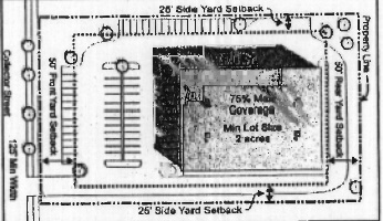
Illustrative layout (does not reflect all requirements contained within this chapter)
(Ord. 2007-1B, passed 2-5-07)
Cross reference:
Development standards, see §§ 156.060 et seq.
Overlay districts, see §§ 156.040 et seq.
Procedures and permits, see §§ 156.100 et seq.
Sign standards, see §§ 156.085 et seq.
(A) District summary. The "IG", Industrial: General zoning district is intended to provide locations for general industrial manufacturing, production, assembly, warehousing, research and development facilities, and similar land uses. This district is intended to accommodate a variety of industrial uses in locations and under conditions that minimize land use conflicts. This district should be used to support industrial retention and expansion in Hancock County.
(B) Permitted primary uses.
(1) Land use matrix. The land use matrix set forth in § 156.021 provides detailed use lists for all zoning districts.
(2) Agricultural uses.
(a) Crop processing and storage (materials produced on-site).
(b) Grazing and pasture land.
(3) Communications/utilities uses.
(a) Communication service exchange.
(b) Utility substation.
(c) Water tower.
(4) Institutional/public uses.
(a) Heliport.
(b) Medical clinic.
(c) Parking lot or structure (as a primary use).
(d) Police, fire, or rescue station.
(e) Trade or business school.
(5) Park uses.
(a) Nature preserve/center.
(6) Commercial uses.
(a) Administrative/professional office.
(b) Conference center.
(c) Data processing/call center.
(d) Radio/TV station.
(7) Industrial uses.
(a) Agricultural products terminal.
(b) Assembly facility.
(c) Fabrication facility.
(d) Food and beverage production.
(e) Lumber yard.
(f) Manufacturing facility.
(g) Mini-warehouse self-storage facility.
(h) Packaging facility.
(i) Printing/publishing facility.
(j) Research and development facility.
(k) Tool and dye shop.
(l) Truck freight terminal.
(m) Warehouse and distribution facility.
(n) Wholesale distribution facility.
(C) Special exception primary uses.
(1) Land use matrix. The land use matrix set forth in § 156.021 provides detailed use lists for all zoning districts.
(2) Agriculture uses.
(a) Agricultural chemical sales, distribution, and storage.
(b) Crop production.
(c) Farm co-op facility.
(d) Farm equipment sales and service.
(e) Fertilizer sales, distribution and storage.
(f) Livestock auction/sales facility.
(g) Livestock raising and breeding.
(h) Nursery.
(i) Seed sales, distribution, and storage.
(j) Winery.
(3) Communications/utilities uses.
(a) Sewage treatment facility.
(b) Telecommunications facility/tower.
(4) Institutional/public uses.
(a) Airport.
(b) Airstrip (private).
(c) Government facility (non-office).
(d) Government office.
(e) Penal or correctional institution.
(f) Public bus/train terminal.
(5) Commercial uses.
(a) Adult uses.
(b) Child care center.
(c) Indoor/outdoor recreation facility.
(d) Motocross facility.
(e) Truck stop/travel center.
(6) Industrial uses.
(a) Animal and animal products processing.
(b) Boat/RV storage facility (outdoor).
(c) Bottle gas storage and distribution.
(d) Concrete/asphalt production facility.
(e) Contractor's warehouse/storage facility.
(f) Explosive manufacturing and storage.
(g) Inoperable vehicle storage.
(h) Junk/scrap metal yard.
(i) Mineral extraction and processing.
(j) Petroleum and chemical processing and storage.
(k) Power generation facility (commercial).
(l) Refuse dump/transfer station.
(m) Sanitary landfill.
(n) Semi-tractor/trailer storage.
(o) Truck sales and service center.
(p) Waste incinerator.
(D) Lot standards.
(1) Minimum lot area: 5 acres.
(2) Maximum lot area: not applicable.
(3) Minimum lot width (measured at front setback/build-to line):1 25 feet.
(4) Maximum lot coverage (including all hard surfaces): 75%.
(5) Minimum front yard setback - (measured from street right-of-way): 100 feet.
(6) Minimum side yard setback - (measured from adjacent property line): 50 feet.
(7) Minimum rear yard setback - (measured from rear property line): 100 feet.
(8) Minimum living area per dwelling: not applicable.
(9) Minimum ground floor living area: not applicable.
(10) Maximum primary structures per lot: not applicable.
(11) Maximum height: 50 feet.
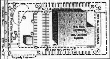
Illustrative layout (does not reflect all requirements contained within this chapter)
(Ord. 2007-1B, passed 2-5-07)
Cross reference:
Development standards, see §§ 156.060 et seq.
Overlay districts, see §§ 156.040 et seq.
Procedures and permits, see §§ 156.100 et seq.
Sign standards, see §§ 156.085 et seq.
OVERLAY ZONING DISTRICTS
(A) Establishment of overlay districts. The overlay districts noted below have been established to provide additional development standards that respond to unique characteristics of the properties to which they apply. The overlay districts will assist Hancock County in providing for the public welfare and accomplishing the goals of the Comprehensive Plan. The development of properties which are located in one or more overlay districts shall be subject to the requirements of both the overlay district(s) and the underlying district in which they are located. The following overlay zoning districts shall apply to properties in the jurisdiction of the Hancock County Area Plan Commission as specified in the description of each district in this subchapter.
(1) | WP-OL | Wellfield Protection. |
(2) | C-OL | Corridor. |
(3) | AP-OL | Airport. |
(4) | V-OL | Rural Village. |
(5) | Shirley Overlay. |
(B) Effect of planned unit development district. All planned unit developments shall be consistent with the requirements of §§ 156.050 et seq. Planned unit developments shall not be subject to the requirements of any overlay district, unless otherwise specified as an element of the planned unit development detailed plan.
(C) Land uses. All land uses which are permitted, non-permitted or a special exception use in any underlying zoning district to which an overlay district is applied shall remain permitted, non-permitted, or special exception uses unless otherwise specified by the applicable overlay district(s).
(D) Lot, yard, and development standards. Any lot, yard, and development standards established by an overlay district shall apply as follows:
(1) Replacement of underlying district standards. All lot, yard, and development standards established by an underlying zoning district shall apply unless alternate standards are provided by the overlay district(s).
(2) Additional overlay district standards. Properties located in any overlay district(s) shall also be subject to any additional lot, yard, and development standards established by the overlay district(s).
(Ord. 2007-1B, passed 2-5-07; Am. Ord. 2014-8C, passed 8-5-14; Am. Ord. 2021-7A, passed 7-20-21)
Cross reference:
Planned unit developments, see §§ 156.050 et seq.
Zoning districts, see §§ 156.020 et seq.
(A) Intent. This section is intended to safeguard the public health, safety, and general welfare of those persons within Hancock County who rely on public and/or utility-operated wellfields for clean, safe drinking water. These regulations are intended to prevent land uses and certain development practices that commonly have the potential to degrade water quality by introducing chemicals, organic hazards, and other potentially harmful elements into the ground water system within the five-year capture area of the wellfields. This includes the introduction of hazardous materials into the area, the creation of hazardous by-products from onsite activities, and the alteration of the land in a manner that increases the exposure of the ground water system to potential contaminants.
(B) Boundaries and exemptions. The Wellfield Protection Overlay District (WP-OL) shall apply to all properties as indicated on the official zoning map of Hancock County, but shall generally conform to the boundaries of the five-year wellfield capture areas within the county's jurisdiction (as updated periodically).
(C) Uses. All uses permitted in the underlying district(s) are permitted in the Wellfield Protection Overlay District; and all uses that are special exceptions in the underlying district(s) are special exceptions in the Wellfield Protection Overlay District unless specifically noted otherwise below.
(1) Prohibited uses. The following uses shall be prohibited in the Wellfield Protection Overlay District (see the land use matrix set forth in § 156.021 for detailed use listings):
(a) Agriculture uses. Agricultural chemicals, products sales, distribution, and storage facility; farm (confined feeding); farm equipment sales and service; greenhouse (commercial); and livestock auction/sales facility.
(b) Communications/utility uses. Sewage treatment plant.
(c) Park uses. Campground/RV park; driving range (as a primary use); golf course and/ or country club (including driving range).
(d) Institutional/public uses. Airport; animal shelter; fairgrounds; government facility (non-office); heliport; hospital/medical center; and medical clinic.
(e) Commercial uses. Auto-oriented uses (small scale); auto-oriented uses (medium scale); auto-oriented uses (large scale); mass transit terminal/station (excluding a public bus stop); kennel; fireworks sales (permanent); and truck stop/travel center.
(f) Industrial uses. Animal and animal products processing; boat/RV storage facility (outdoor); concrete/asphalt production facility; contractor's warehouse/storage facility; food and beverage production; general industrial production; hazardous materials production; light industrial assembly and distribution; light industrial processing and distribution; mineral extraction and processing; research and development facility; truck freight terminal; truck sales and service center; and waste disposal facility.
(2) Uses not specified. The Plan Commission, through the site development plan review process, may also prohibit or impose conditions on other uses not listed in division (C)(1) above that are reasonably demonstrated to pose a hazard to the drinking water supply due to chemicals used onsite or by-products of onsite activities. Some examples of this type of use may include building cleaning or maintenance service companies, engineering or vocational shops or laboratories, landscape or lawn installation or maintenance services, and mortuaries.
(D) Development standards. All development within the boundaries of the Wellfield Protection Overlay District shall comply with all applicable state, federal, and local regulations, in addition to the following development standards.
(1) Abandoned wells. All known abandoned wells shall be identified and sealed consistent with any applicable requirements of the County Engineer.
(2) Surface water impoundments.
(a) No surface impoundments, ponds, or lagoons shall be established except for the purpose of:
1. Storm water retention and detention ponds, or
2. Recreation and landscaping purposes.
(b) All detention and retention ponds shall be constructed in a manner that provides an effective barrier to the migration of potential contaminants into the ground water and in accordance with the Stormwater Drainage Ordinances of Hancock County or McCordsville.
(3) Public sewer service. All development, with the exception of a single-family residence located on a lot of at least two acres, shall be connected to a public sewer. All floor drains must be routed to a temporary holding area for future removal or as otherwise permitted by the Planning Director.
(4) Trash and recycling containers. All non-residential trash and recycling containers shall be located on hard-surfaced areas that drain to a public storm sewer.
(5) Storage and transfer of potential contaminants. All areas that may be used for the storage and/or transfer of potential ground water contaminants shall be constructed in a manner to prevent any release from the area from reaching the ground water. The containment area shall be capable of, at a minimum, containing 110% of the potentially hazardous material for which the area has storage and transfer capacity.
(6) Auto repair facilities. All vehicle and auto repair facilities shall be located within an enclosed building that includes a floor constructed of material that forms an effective barrier to prevent the migration of fluids or other materials into the ground water.
(Ord. 2007-1B, passed 2-5-07)
(A) Intent.
(1) The purpose of this section is to establish an overlay district to address the unique characteristics of the properties adjacent to Hancock County's transportation routes. These corridors have unique traffic management needs, development pressures, and aesthetic characteristics that require the establishment of additional development standards to meet the goals of the Comprehensive Plan and fulfill the purpose of this chapter.
(2) The intent of the Corridor Overlay District is to require development along the county's thoroughfares that is aesthetically consistent, responsive to development pressures, and proportional to the area's traffic management issues.
(B) Boundaries and exemptions. The Corridor Overlay District (C-OL) shall apply to all development sites, buildings, structures, plantings, signs, street hardware, and any other improvements that are visible to the public and affect the physical development of land within the I-70, US 40, US 52, US 36/SR67, SR 9 north of Greenfield past Maxwell, the crossing of SR 234 and 200W, and CR 600W between the US 52 and US 36/SR 67 corridor overlay zones as shown on the official zoning map or as measured 600 feet from the centerline of the corridor street. Breaks and widths of corridor overlays can be seen on the official zoning map. All agricultural, single and two-family residential uses shall be exempt from the requirements of this overlay district.
(C) Uses. All uses permitted in the underlying district(s) are permitted in the Corridor Overlay District. All uses that are special exceptions in the underlying district(s) are special exceptions in the Corridor Overlay District.
(D) Development standards. All commercial development within the boundaries of the Corridor Overlay District shall comply with the development and design standards set forth in this section. The visibility and accessibility of the land within the corridors is unique and therefore commands the highest standards of development which stimulate substantial capital investments, encourage efficient land use, promote coordinated development, permit innovative site designs, establish development standards and preserve the integrity of the roadways within the corridors.
(1) Vehicular access. The corridor streets which function as primary thoroughfares must have reasonable restrictions as to the number and location of access points within the overlay zone. Access shall be approved by the town, County Highway Engineer or INDOT depending on jurisdiction. To provide safe and sufficient traffic movement to and from adjacent lands:
(a) Frontage roads, access roads, and distributors roads may have to be constructed.
(b) Shared access shall be coordinated with contiguous lots and designed to preserve the aesthetic benefits provided by the greenbelt areas. Access at the side or rear of buildings is encouraged.
(c) New access points onto the primary thoroughfares in the corridors shall be coordinated with existing access points whenever possible and approved by the town, County Highway Engineer or INDOT depending on the jurisdiction.
1. The following curb cut policy shall apply throughout the US 40, US 52, US 36/SR 67, and CR 600W corridors.
2. Curb cuts shall be no closer than one foot for each 400 feet of frontage.
3. No curb cuts shall be within 200 feet of any intersection of public roads.
4. Opposing curb cuts shall align squarely or be offset no less than 200 feet.
(2) Access to undeveloped sites. Stub streets shall be built in all cases where adjacent lots have reasonable potential for development. "Reasonable potential" shall include any adjacent parcel of adequate size for commercial or residential development or any adjacent parcels determined by the County Area Plan Commission or its duly appointed or designated representative.
(3) Site layout. Development plans shall include the full development of the site. Ownership patterns may limit the degree to which this can be shown. Plans should indicate phasing and be prepared in accordance with the requirements of §§ 156.100 et seq.
(a) Site layout shall consider the relationship between all buildings on site.
(b) Pedestrian connectivity between uses shall be shown.
(c) The amount of offstreet parking located between the street and the front facade of the building shall not exceed 80% of the total parking requirement.
(d) Internal drive aisles that connect multiple lots shall minimize points of access for safe vehicular circulation.
(e) The orientation and access for outlots shall be considered and show on the plan.
(4) Architectural standards. The following architectural standards shall apply to commercial facilities:
(a) Facade. The facade is the wall that fronts on a public or private street. If the structure fronts onto more than two streets, the wall that faces the streets with the highest Thoroughfare Plan classification, shall be treated as the front facade. Facades on outlots/outparcels shall have exterior treatments similar to that on the front facade. All front facades shall incorporate the following elements.
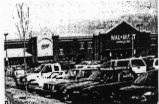
(“Big box” commercial with enhanced architecture)
1. Recesses/projections. Wall recesses/projections that are at least 12 inches for every 70 feet of facade. The projection shall extend for at least 20% of the length.
2. Entry features. Entryway features are only required at the primary entrance to the structure and shall include at least three of the following design elements:
a. Raised corniced parapets over the door, peaked roof forms having an average slope greater than or equal to a minimum 5/12 pitch, arches, or architectural details such as tile work and moldings that are integrated into the building structure and design;
b. Integral planters or wing walls that incorporate landscaped areas and/or places for sitting;
c. Enhanced exterior lighting such as wall sconces, building mounted accent lights, or decorative pedestal lights;
d. Prominent three-dimensional entryway feature, such as a clock tower or other similar architectural design element, projecting from the plane of the main exterior walls by a minimum of eight feet and raised above the adjoining parapet wall/roof by a minimum of three feet; and
e. Pilasters projecting from the plane of the wall by a minimum of eight inches and/or architectural or decorative columns to create visual breaks and interest in the facade walls.
3. Display windows. All facade walls shall have display windows, faux windows, or decorative windows for no less than 60% of the facade's horizontal length along all pedestrian walkways.
4. Entrances. All facades that abut a street, public or private, shall feature as least one customer entrance.
5. Detail features. Building facades shall include a repeating pattern that incorporates no less than three of the elements listed below. At least one of these elements shall repeat horizontally. All elements shall repeat at intervals of no more than 100 feet, either horizontally or vertically.
a. Color change.
b. Texture change.
c. Material module change.
d. Architectural change: In the form of structural bays created through a change in plane no less than 24 inches wide such as an offset, reveal, or projecting rib.
e. Story change: A clear delineation between each story of the structure provided by a consistent cornice line.
6. Exterior materials. The use of smooth-faced concrete block, untextured smooth-faced tilt-up panels, and standing seam metal panels shall be prohibited. The Planning Director shall approve or deny the use of all composite and alternative materials that replicate the appearance and durability of those listed below. All facade wall exterior building materials shall be high quality, and shall be limited to any combination of the following:
a. Brick or face tile;
b. Wood;
c. Native stone;
d. Glass (reflective glass shall be limited to a maximum of 50% of the area of any facade wall on which glass is used);
e. Tinted and/or textured concrete masonry units (such as split face block and burnished block);
f. Tilt-up concrete panels that are adorned or textured;
g. Architectural precast concrete;
h. Architectural metal;
i. E.I.F.S; and
j. Fiber cement board.
7. Exterior colors. Exterior facade wall colors shall be low reflectance and subtle tones. The use of high intensity, primary, metallic, black or fluorescent colors shall be prohibited. Building trim and accent areas may feature brighter colors or primary colors. Such building trim and accent areas shall not exceed 10% of any single exterior wall area excluding all windows, doors, and glass construction materials.
8. Roof design. All roofs or parapets should vary three-dimensionally to add visual interest to the building and shall include architectural detailing, cornices, moldings, trims, variations in brick coursing, and other similar detailing. All roofs shall comply with the following:
a. All rooftop mechanical equipment, such as HVAC units, shall be screened from the view of all streets (public and private) by parapets, dormers, or other screens on properties within the corridor overlay. The material of all such screens shall be consistent with the exterior materials used on the facade of the structure.
b. Sloped roofs shall not exceed an average height equal to that of the supporting walls.
c. Sloped roofs shall have overhanging eaves that extend a minimum of eight inches past the supporting walls.
d. Sloped roofs shall either be of architectural standing seam metal, tile, slate, or dimensional shingles.
(5) Pedestrian circulation and public spaces. The following provisions are intended to maximize the safety of the site for vehicles and pedestrians and shall apply to all commercial facilities.
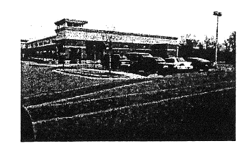
(Parking lot with special paving and landscape)
(a) Pedestrian facilities. A continuous, delineated pedestrian pathway network no less than six feet wide, that continues from the perimeter public sidewalk to the principal customer entrance of all principal buildings on the site shall be provided.
1. Sidewalks, no less than eight feet wide, must be provided along the full length of the building along any facade that features a customer entrance.
2. All internal pedestrian walkways shall be distinguished from driving surfaces through the use of special pavers, bricks, or scored concrete. The design characteristics of the internal pedestrian walkways must continue when the walkway crosses driving surfaces.
3. All internal walkways must feature landscaping, benches, and other such materials/ facilities for no less than 50% of their length. Internal walkway features can be composed of any combination of the following: benches, tree plantings decorative lighting (no more than ten feet in height), decorative bollards, kiosks, shrubs, or hedges.
(b) Public spaces. Each establishment must contribute to the enhancement of the community and its public spaces by providing at least two of the following amenities.
1. A landscaped patio/outdoor seating area or plaza that is a minimum of 2,000 square feet in area.
2. A water feature (excluding any required detention/retention ponds).
3. A clock or bell tower or other vertical element (either as a freestanding structure or in conjunction with the primary entrance features).
4. Bus/public transportation shelters and turn off lanes.
5. Public art or sculpture.
6. A mini park.
(6) Outdoor storage, service and loading areas. Areas for outdoor storage, truck parking, trash collection/compaction, loading and unloading, or other such uses shall not be visible from abutting streets (public or private), or adjacent non-industrial properties.
(Screened trash and loading area)
(a) Delivery and auto service areas. Service areas including, but not limited to, loading docks, truck courts, and automobile service bays shall be oriented away from the view of any public street or adjacent residential zoning district or use unless screened by an eight-foot masonry wall constructed of materials compatible with the primary architecture, and extending the entire length of the service area.
1. The service areas shall have additional screening along the exterior side of the masonry wall in the form of landscaping buffer, designed by a landscape professional, to be 100% opaque and four feet in height at the time of planting.
2. No property owner shall be permitted to inhibit the height and density of any required landscaping outlined in this section except for maintenance purposes.
(b) Permanent outdoor display, sales and storage.
1. Merchandise may be stored or displayed for sale to customers only in areas immediately adjacent to the primary structure on each property. The storage of outdoor merchandise for sale elsewhere on the property shall be prohibited. This area shall be:
a. Enclosed by a minimum eight-foot tall wall, or
b. Composed of a three-foot tall base wall topped by wrought iron or tubular steel fencing.
2. No merchandise other than trees shall be visible above the wall or fencing. Each wall shall comply with the building materials requirements of division (D)(4)(a)6. above and shall be consistent in appearance and material as the primary structure on the property.
(c) Shopping cart storage. Shopping carts may be stored outside each entrance to the building provided that there are no more than two cart storage areas (on each side of the entryway) and that no single cart storage area exceeds 20 feet in length. The cart storage areas shall be screened with building materials substantially similar to the building facade.
Illustrative layout (does not reflect all requirements established by this chapter)
(Ord. 2007-1B, passed 2-5-07)
(A) Intent. The Airport Overlay District permits operation of the Mt. Comfort Airport and regulates uses adjoining the airport to ensure compatible growth and development. District regulations control building height and prohibit uses that create electrical interference. Underlying districts define permitted uses in the Airport Overlay District.
(B) Definitions. For the purpose of this section, the following definitions shall apply unless the context clearly indicates or requires a different meaning.
ACT. The Indiana Tall Structure Act, being I.C. 8-21-10 and as hereafter amended.
AIRPORT. Mt. Comfort Airport.
AIRPORT HAZARD. Any structure, tree, object, or use of land which penetrates the airspace reserved herein for passage of aircraft or is otherwise hazardous to the flight of aircraft in landing or taking off at the airport.
AIRPORT REFERENCE POINT. The point established as the approximate geographic center of the airport landing area.
AIRPORT ZONING MAP. The map showing height restriction zones for Mt. Comfort Airport. The airport zoning map was adopted with the height ordinance for property in the vicinity of Mt. Comfort Airport, also known as Ordinance 2009-3C, and is made part of this section and the official county zoning map by reference.
ESTABLISHED AIRPORT ELEVATION. The established elevation of the highest point on the landing area, which is 863 feet above mean sea level (MSL).
HEIGHT. For the purpose of determining the height in limits in all zones set forth in this section and shown on the airport zoning map, the datum shall be mean sea level (MSL) elevation unless otherwise specified.
LANDING AREA. The area of the airport used for the landing, take off, or taxiing of aircraft.
NOISE SENSITIVE ZONE. The Act at I.C. 8-21-10-3 defines a noise sensitive zone as an area lying 1,500 feet on either side of the extended centerline of a runway for a distance of one nautical mile from the boundary of a public use airport which definition is incorporated herein and made a part of this chapter.
NONCONFORMING USE. Any structure, tree, or use of land which is lawfully in existence at the time of this section or an amendment thereto becomes effective and which does not then meet the requirements of this section or amendment.
NON-PRECISION INSTRUMENT RUNWAY. A runway that has or is planned to have and is so indicated on a Federal Aviation Administration (FAA) planning document, an electronic approach guidance system utilizing navigational aids that provide horizontal course alignment guidance and position location, but not electronic descent guidance which authorizes aircraft to execute non-precision approaches with visibility minimums down to and including ¾ mile.
PERSON. An individual, firm, partnership, corporation, company, association, joint stock association, or body politic, and includes a trustee, receiver assignee, administrator, executor, guardian, or other representative.
PRECISION INSTRUMENT RUNWAY. A runway that has or is planned to have and is so indicated on a Federal Aviation Administration (FAA) planning document, an electronic approach system utilizing navigational aids that provide electronic descent guidance in addition to the course alignment guidance of a non-precision instrument runway which authorizes aircraft to execute precision approaches with visibility minimums of ¾ mile or less.
RUNWAY. The surface of an airport used for landing and taking off of aircraft.
RUNWAY CLEAR ZONE. The land underlying a Precision Instrument Approach Surface, a Non-Precision Instrument Approach Surface or a Visual Approach Surface as defined in this chapter extending for the first 5,200 feet of the respective approach surface measured horizontally from the runway end along the extended centerline of such runway.
STRUCTURE. An object constructed or installed by man, including, but without limitation thereof buildings, towers, smokestacks, and overhead transmission lines.
TERMINAL NAVIGATIONAL AIDS (NAVAIDS). Those facilities and equipment installed on or near the airport for the purpose of providing pilots with electronic guidance or visual reference to use in executing an approach to land at the airport.
TREE. Any object of natural growth.
VISUAL RUNWAY. A runway that is used only under visual flight rules (VFR) and/or for circle to land instrument flight procedures.
(C) Height restriction zones. There are hereby created and established certain zones which include all of the land lying within and under the approach surfaces, transition surfaces, horizontal surfaces, and conical surfaces. The zones and surfaces are shown on the Mt. Comfort Airport zoning map. The various zones are hereby established and defined as follows:
(1) Precision instrument approach surface. The land area located at each end of each instrument runway to be equipped for precision landings, its surface area having a width of 1,000 feet at a horizontal distance of 200 feet beyond each end of the runway and widening thereafter uniformly to a width of 16,000 feet at a horizontal distance of 50,200 feet beyond each end of the runway, its centerline being the continuation of the runway centerline.
(2) Non-precision instrument or visual approach surface. The land area located at each end of each non-precision instrument or visual runway for landings and take-offs, its surface area having an inner width identical to width of the primary surface at a width of 4,000 feet at a distance of 10,200 feet beyond the end of the runway. The approach surface centerline is the continuation of the runway centerline.
(3) Primary surface. A surface longitudinally centered on a runway. When the runway has a specially prepared hard surface, the primary surface extends 200 feet beyond each end of that runway, but when the runway has no specially prepared hard surface or planned hard surface, the primary surface ends at each end of that runway. The elevation of the nearest point on the primary surface is the same as the elevation of the nearest point on the runway centerline. The width of a primary surface is 500 feet for visual runways and 1,000 feet for all other runways. The width of the primary surface is the width prescribed for the most precise approach to either end of the runway.
(4) Transitional surface. These surfaces extend outward and upward at right angles to the runway centerline and the runway centerline extended from the sides of the primary surface and from the sides of the approach surfaces. Transitional surfaces for those portions of a precision approach surface which project through and beyond the limits of the conical surface, extend a distance of 5,000 feet measured horizontally from the edge of the approach surface and at right angles to the runway centerline.
(5) Horizontal surface. A horizontal plane 150 feet above the established airport elevation, the perimeter of which is constructed by swinging arcs of specified radii from the center of each end of the primary surface of each runway of each airport and connecting the adjacent arcs by lines tangent to those arcs. The radius of each arc is 5,000 for visual runways and 10,000 for all other runways.
(6) Conical surface. The land area beginning at the periphery of the horizontal surface area and thence extending outwardly for a horizontal distance of 4,000 feet.
(D) Height limitations. Except as otherwise provided herein, no structure or tree shall be erected, altered, allowed to grow, or maintained in any zone created by this section to a height in excess of the height limit herein established for the zone. The height limitations are computed from the applicable runway and elevation or the airport elevation as appropriate, and are hereby established for each of the zones in question. When an area is covered by more than one height limitation, the more restrictive limitation shall prevail. Nothing in this section shall be construed as prohibiting the growth, construction, or maintenance of any tree or structure to a height 50 feet or less above the surface of the land.
(1) Precision instrument approach surface. Height limits shall be one foot in height for each 100 feet in horizontal distance beginning at a point 200 feet from the end of the instrument runway and extending to a distance of 10,200 feet from the end of the runway, thence one foot in height for each 50 feet in horizontal distance to a point 50,200 feet from the end of the runway.
(2) Non-precision instrument approach surface. Height limits shall be one foot in height for each 50 feet in horizontal distance beginning at a point 200 feet from the end of the non-precision instrument runway and extending to a point 10,200 feet from the end of the runway.
(3) Transitional surface. Height limits shall be one foot in height for each seven feet in horizontal distance beginning at the primary surface edge, measured at right angles to the longitudinal centerline of the runway, extending upward to a maximum height of 150 feet above the established airport elevation. In addition to the foregoing, there are established height limits of one foot in vertical height for each seven feet in horizontal distance measured from the edges of all approach surfaces for the entire length of the approach surface and extending upward and outward to the points where they intersect the horizontal and conical surfaces. Further, where the instrument approach surface projects through and beyond the conical surface, a height limit of one foot for each seven feet of horizontal distance shall be maintained beginning at the edge of the instrument approach surface and extending a distance of 5,000 feet from the edge of the precision instrument approach surface measured at right angles to the continuation of the centerline of the runway.
(4) Conical surface. Height limits shall be one foot in height for each 20 feet of horizontal distance beginning at the periphery of the horizontal surface and measured perpendicularly to the periphery of the horizontal surface.
(E) Use restrictions. No use may be made of land within any zone established by the subchapter in a manner as to create electrical or radar interference with radio communication between the airport and aircraft, making it difficult for flyers to distinguish between airport lights and others, resulting in glare in the eyes of the flyers using the airport, impairing visibility in the vicinity of the airport, or otherwise endangering the landing, taking off, or maneuvering of aircraft.
(1) Bird strike hazard restrictions. No waste disposal site, solid waste transfer station, recycling facility, or other bird attracting use shall be located within the AP-OL district without approval and proper authorization by the Federal Aviation Administration.
(2) Exempt uses. The following uses and structures are exempt from these height restrictions:
(a) A structure or object that is shielded by existing permanent structures or by natural terrain or topographic features of equal or greater height and is located in an area of established development where it is evident that the shielded structure would not adversely affect aircraft navigation.
(b) Any air navigation facility, airport visual approach or landing aid, aircraft arresting device, or meteorological device of a type approved by the FAA and the height of which is fixed by its functional purpose.
(c) Any structures owned or maintained by the airport or any branch of government for utility purposes.
(3) Prohibited uses. The following types of uses shall be prohibited within the runway clear zone:
(a) Auditoriums.
(b) Amphitheaters.
(c) Day care facilities.
(d) Concert halls.
(e) Hospitals.
(f) Major residential plats.
(g) Major commercial or industrial plats with a residential component.
(h) Mobile home parks.
(i) Nursing homes.
(j) Outdoor music facilities.
(k) Public and private educational institutions.
(l) Religious places of worship.
(m) Wireless communication facilities.
(n) Any uses involving the sales, storage, manufacture, and/or distribution of gasoline, propane, or other flammable, toxic, explosive, radioactive, biohazardous materials in a quantity and of a type that would further jeopardize the health of aircraft occupants, bystanders, and emergency personnel in the event of an aircraft accident.
(o) Any uses not expressly identified above, in addition to all uses legally existing before the effective date of this chapter, shall be permitted in the runway clear zone.
(4) Special exception uses. The following types of uses shall be special exceptions within the runway clear zone, provided that they are also listed as permitted or special exception uses in the underlying standard zones:
(a) Mixed non-residential uses.
(b) Shopping centers not exceeding 15,000 square feet in gross floor area.
(c) Cemeteries.
(d) Hotels.
(5) Noise protection. All structures as defined in the Act permitted in the noise sensitive zone after effective date of this chapter shall obtain a noise-sensitive permit from the Indiana Department of Transportation, Aeronautics Section in accordance with the procedures specified in the Act at I.C. 8-21-10-3.
(F) Nonconforming uses. The height limits and use limitations established by this section shall not be construed to require the removal, lowering, or other changes or alteration of any structure or tree not conforming to the regulations as of the effective date of this subchapter, or otherwise interfere with the continuance of any nonconforming use. Nothing herein shall require any change in construction, alteration, or intended use of any structure, the construction or alteration of which was begun prior to the effective date of this chapter, and is diligently prosecuted.
(G) Safety lights. The owner of any nonconforming structure or tree is hereby required to permit the installation, operation, and maintenance thereon of markers and lights as shall be deemed necessary by the Indianapolis Airport Authority to indicate to the operators of aircraft in the vicinity of the airport the presence of airport hazards. The markers and lights shall be installed, operated, and maintained at the expense of the Indianapolis Airport Authority.
(H) Permits. No permit for construction or alteration of a structure or use within the Airport Overlay District shall be granted except in accordance with the following provisions:
(1) Airport hazards. No permit shall be granted for the establishment or creation of an airport hazard or to permit a nonconforming use, structure, or tree to be made or to become higher, or to become a greater hazard to air navigation than it was on the effective date of this chapter or any amendments thereto, or than it is when the application for a permit is made.
(2) Abandonment. Whenever the Planning Director or designated authority determines that a nonconforming structure or tree has been abandoned or more than 80% torn down, physically deteriorated or decayed, no permit shall be granted that would allow the structure or tree to exceed the applicable height limit or otherwise deviate from the zoning regulations.
(Ord. 2007-1B, passed 2-5-07; Am. Ord. 2009-3C, passed 3-9-09)
(A) Intent. Development standards should promote the health safety and welfare and preserve the character and pedestrian scale of the village. Development standards should reflect the existing size, scale and massing of structures and pedestrian orientation and interconnectivity of the streets.
(B) Boundaries and exemptions. The Village Overlay District (V-OL) shall apply to Spring Lake and village areas as designated on the Official Zoning Map of Hancock County.
(C) Uses. All uses permitted in the underlying district(s) are permitted in the Village Overlay District. All uses that are special exceptions in the underlying district(s) are special exceptions in the Rural Village Overlay District.
(D) Development standards. All development within the boundaries of the Village Overlay District shall comply with the following development standards. Under conditions where a strict interpretation of the design and development standards cannot be met, a modification to the development plan may be proposed to maintain the spirit rather than the letter of the law. In addition, developments with distinct and unique architectural designs may be considered. The request of modification shall be submitted to the Planning Commission for review.
(1) Applicability. This overlay, unless otherwise noted, shall apply to all public, private, and institutional development. Unless specified, requirements and development standards of the CN: Commercial Neighborhood District shall apply.
(2) Review. Development plans in this zoning classification shall be subject to review by the Area Plan Commission and/or its designees in accordance with the procedures in § 156.107.
(3) Streets. Public streets and alleys shall be designed to the standards set forth in the Hancock County Thoroughfare Plan as approved by the County Highway Engineer. If a town thoroughfare plan exists, then the streets and alleys shall be designed to the standards set forth in the town thoroughfare plan within the town jurisdiction.
(4) Architectural.
(a) Scale and massing. The architectural design of development shall reflect scale and massing of development within the district. Similar massing can be achieved by respecting existing setbacks, proportionate sizing of windows, doorways, rooflines and similar use of exterior and landscape materials. One-story buildings along the street elevation shall incorporate architectural elements such as three-dimensional cornices, dormers, windows and parapet walls to provide the illusion of an additional one-half to one story.
(b) Setbacks.
1. Front. Setbacks shall be equal to the average setbacks for buildings on the same side of the street within 100 feet. Where there are no such buildings, the minimum front yard setback is determined by the classification of the adjoining road as noted on the Thoroughfare Plan.
2. Side. Setbacks shall be equal to the average setbacks for buildings on the same side of the street within 100 feet, or the minimum sideyard setback as stated in the applicable underlying zoning district, which ever is less.
(c) Facades. Architectural design shall be in context with existing development. All siding shall be natural materials such brick, stone, wood, or fiber cement plank siding, decorative precast panels, E.I.F.S. or a combination of these materials. Color should be subtle, neutral hues and of low reflectance. Building materials shall not include smooth-faced concrete block or concrete tilt-up panels. The street level facade should be at least 60% transparent to discourage blank unarticulated facades. The rear elevation of the building will be consistent in finish with the front facade of the building; however, the high degree of architectural detailing and articulation seen on the front will not be required.
(d) Entries. Entryways shall be clearly defined and contain such features as canopies, porticos, arcades, raised corniced parapets, arches, awnings, integral planters, etc.
(e) Roofs. Roofs shall have at least two of the following features:
1. Parapets. Parapets shall not exceed 30% of the height of the supporting wall and must conceal flat roofs.
2. Cornice. Cornices shall be three dimensional.
3. Eaves. Eaves and overhangs shall be a minimum of three feet past the supporting walls.
4. Cupolas.
5. Dormers.
6. Roof pitch. Roof pitch shall be a minimum of 5:12 pitch on a sloped roof; a facade gable shall be a minimum of 8:12 pitch.
(f) Service areas. All delivery service areas shall employ walls or landscaping to screen views.
(g) Mechanical equipment. Ground, building and roof-mounted mechanical equipment shall be screed from view. Landscaping, fences, walls and parapet walls on roofs can be used.
(5) Parking.
(a) On-street parking shall be permitted in this district and shall count towards required parking.
(b) Shared parking. Cooperative provisions for off-street parking may be made by contact between two or more adjacent property owners. The parking area provided on any one lot may be reduced to not less than 75% of the number of required parking spaces for the use occupying such lot.
(c) To the extent that developments make joint use of the same parking spaces at different times, up to 1/2 of the parking spaces may be credited to both uses if one use is a church, theater, professional offices or assembly hall shoes peak hours of attendance will be at night or on Sundays, and the other use or uses are ones that will be closed at night or on Sundays.
(6) Landscaping. A premium shall be placed on the preservation of existing mature plant material and credit shall be given towards in-kind required landscaping. Landscaping requirements for commercial zoning districts as set forth in §§ 156.060 et seq. shall apply.
(7) Lighting. Decorative lighting shall be used for streets, parking lots, buildings and landscaping.
(8) Site amenities. Plazas, mini-parks, water features, flagpoles, public art, and coordinated site furniture are encouraged.
(a) Signage shall be designed to be an integral part of the site context and architectural features. The scale, colors and materials of signs shall be compatible and harmonious with existing development.
(b) Sign shall be visible to both motorists and pedestrians.
(c) Signs shall be externally illuminated. No signage illumination shall be so designed, located or directed to cast glare or direct light onto adjacent public roadways.
(Ord. 2007-1B, passed 2-5-07; Am. Ord. 2007-6A, passed 6-4-07; Am. Ord. 2014-8C, passed 8-5-14; Am. Ord. 2021-7A, passed 7-20-21)
Loading...