1. Purpose. The purpose of these zones is to prevent injury and/or the loss of property and life and to avoid safety hazards by:
A. Regulating the height of buildings, structures, and natural plant growth within all AH zones which might otherwise have the potential for endangering the lives and property of the users of all public airports within Dover Township and the surrounding vicinity, and the property or occupants of land in the vicinity of the public Airports. (Such hazards might be created by an obstruction which could reduce the size of areas available for the landing, takeoff, and maneuvering of aircraft, thus tending to destroy or impair the utility of the public airports).
B. Encouraging and/or requiring the removal, alteration, or marking and lighting of obstructions, whether manmade or natural, which are potential hazards to air navigation in the vicinity of all public Airports.
C. Endeavoring to protect individuals who intend to buy or acquire interest in lands, buildings, or structures which are located within an Airport Hazard Zone.
2. Warning and Disclaimer of Liability.
A. The degree of protection from danger, loss, or injury sought by the provisions of this Chapter is considered reasonable for regulatory purposes and is based on information provided by the Pennsylvania Department of Transportation's Bureau of Aviation pursuant to Act 164, 1984 Pa. Laws 164, Chapter 59, Subchapter B, 74 Pa.C.S.A. §5915(a). This Chapter does not imply that accidents involving aircraft utilizing public Airports and hazards or obstructions in the vicinity of that airport will be or can be avoided solely by the adoption and/or enforcement of the regulations contained herein.
B. This Section shall not create liability on the part of Dover Township or any officer or employee thereof for any airport and/or airport hazard related damage, loss, or injury that results from reliance on this Section of any administrative decision lawfully made thereunder.
3. Definitions. The following definitions relate solely to the airport hazard regulations and shall not apply universally nor shall said regulations be used to interpret other sections of this Part which do not directly apply to airport hazard zoning.
Aircraft - any contrivance, except an unpowered hang glider or parachute, used for manned ascent into or flight through the air.
Airport - any area of land or water which is used, or intended to be used, for airport buildings or air navigation facilities or right-of-way, together with all airport buildings and facilities thereon. As used herein, the term “airport” includes public airports but excludes private airports and heliports. Public and private airports are defined separately in this subsection.
Airport elevation - the highest point of an airport's usable landing area measured in feet above sea level. (The airport elevation of the York Airport is 486 feet. The airport elevation of the Lazy B Airport is 450 feet).
Airport hazard - any structure or object, natural or manmade, or use of land which obstructs the airspace required for flight or aircraft in landing or taking off at an airport or is otherwise hazardous as defined by “airport hazard” in 74 Pa. C.S.A. §5102.
Airport hazard area - any area of land or water upon which an airport hazard might be established if not prevented as provided for in this Section and the Act 164 of 1984 (Pennsylvania Laws Relating to Aviation).
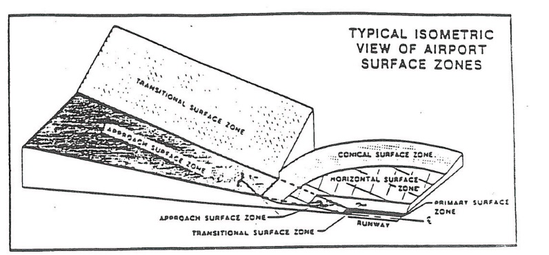
Approach surface - A surface longitudinally centered on the extended runway centerline, extending outward and upward from the end of the primary surface and at the same slope as the approach surface zone height limitation 20:1. In plan the perimeter of the approach surface coincides with the perimeter of the approach surface zone.
Conical surface - a surface extending outward and upward from the periphery of the horizontal surface at a slope of 20 to 1 for a horizontal distance of 4,000 feet.
Department - Pennsylvania Department of Transportation.
FAA - Federal Aviation Administration of the United States Department of Transportation.
Height - for the purpose of determining the height limits in all zones set forth in this Section and shown on the zoning map, the datum shall be mean sea level elevation unless otherwise specified.
Horizontal surface - a horizontal plane 150 feet above the established airport elevation, the perimeter of which in plan coincides with the perimeter of the horizontal surface zone.
Nonconforming use - any pre-existing structure, object of natural growth, or use of land which is inconsistent with the provisions of this Section or an amendment thereto.
Obstruction - any structure, growth, or other object, including a mobile object, which exceeds a limiting height set forth in this Section.
Person - an individual, firm, partnership, corporation, company, association, joint stock association, or governmental entity; includes a trustee, a receiver, an assignee, or a similar representative of any of them.
Primary surface - A surface longitudinally centered on a runway. When a runway has a specifically prepared hard surface, the primary surface extends 200 feet beyond each end of the runway. The width of the primary surface is 250 feet. The elevation of any point on the primary surface is the same as the elevation of the nearest point on the runway centerline.
Private airport - an airport which is privately owned and which is not open or intended to be open to the public as defined in 74 Pa.C.S.A. §5102.
Public airport - an airport which is either publicly or privately owned.
Runway - a defined area of an airport prepared for landing and takeoff aircraft along its length.
Structure - an object, including a mobile object, constructed or installed by man, including, but not limited to, buildings, towers, cranes, smokestacks, earth formations, and overhead transmission lines.
Transitional surfaces - these surfaces extend outward at 90 degree angles to the runway centerline and the runway centerline extended at a slope of seven feet horizontally for each foot vertically from the sides of the primary and approach surfaces to where they intersect the horizontal and conical surfaces.
Visual runway - a runway intended solely for the operation of aircraft using visual approach procedures.
4. Establishment of Airport Hazard Zones. The affected area of Dover Township related to the York Airport is the Village of Admire south to the Township line, east to Berlin Road where the Township line intersects, and west to the Robin Road/Admire Road intersection; containing ± 2,000 acres of area. The affected area of Dover Township related to the Lazy B Ranch Airport is Bull Road at the Township and eastern boundary, south to the Bull Road crossing of the Little Conewago Creek, west to the Dover Elementary School and north to Brehmer Road/Bull Road intersection; containing ± 3,000 acres of area. (refer to the Airport Hazard Overlay Maps at the end of this section).
A. Description of Zones.
(1) Basis of Zones. The various Airport Hazard Zones shall include all defined areas delineated below with limitations based on elevations, specified in this Section of the Chapter.
(a) Approach Surface Zone. Established beneath the visual approach surface. The inner edge of this zone coincided with the width of the primary surface and is 250 feet wide. The zone expands outward uniformly to a width of 1,250 feet at a horizontal distance of 5,000 feet from the primary surface. Its centerline is the continuation of the centerline of the runway.
(b) Horizontal Surface Zone. Established beneath the horizontal surface, 150 feet above the established airport elevation, the perimeter of which is constructed by swinging arcs of 5,000 feet radii from the center of each end of the primary surface of each runway and connecting the adjacent arcs by drawing lines tangent to those arcs. The horizontal surface zone does not include the approach surface and transitional surface zones.
(c) Conical Surface Zone. Established beneath the conical surface. This zone commences at the periphery of the horizontal surface and extends outward there from a horizontal distance of 4,000 feet.
(d) Transitional Surface Zone. Slopes seven feet outward for each foot upward beginning at the sides of and at the same elevation as the primary surface and approach surface, and extending to a height of 150 feet above the airport elevation.
(2) Overlay Concept.
(a) The aforementioned Airport Hazard Zones shall be overlays to the existing and underlying zones as shown on the Official Zoning Map of Dover Township, and as such, the provisions for the Airport Hazard Zones shall serve as a supplement to the underlying zone provisions.
(b) Where there exists any conflict between the provisions of any Airport Hazard Zones and those of any underlying zone the more restrictive provisions shall apply.
B. Inclusion in Zoning Map. The boundaries of the Airport Hazard Zones are established as shown on the York Airport Hazard Overlay Map and the Lazy “B” Ranch Airport Hazard Overlay Map, attached hereto.
C. Zone Boundary Changes. The delineation of any of the airport hazard areas may be revised by the Board of Supervisors only in instances where natural or manmade changes have occurred or corrections are required and detailed studies have been conducted by the Pennsylvania Department of Transportation, Bureau of Aviation, the Federal Aviation Administration or another qualified agency(s) or individual(s) approved by the Bureau and the FAA, and both the Bureau and the FAA recommend and document the advisability of such change.
D. Interpretation of Zone Boundaries. Initial interpretations of the boundaries of the Airport Hazard Zones shall be made by the Zoning Officer. Should a dispute arise concerning the boundaries of any of the zones, the person questioning or contesting the location of the zone boundary should be given a reasonable opportunity to present his/her case to the Township Zoning Hearing Board and to submit his/her own technical evidence if he/she so desires.
E. Status of Airport. If a change in the airport is proposed, through improvements to lighting, runways, etc., that would affect airport hazard zoning (i.e., that would necessitate a modification of height and/or distance requirements), the owner and/or operator of the airport must notify the Township's Board of Supervisors in order that this Section may be amended to reflect such changes.
5. Provisions. All uses, activities, and development occurring within an Airport Hazard Zone shall be undertaken only in strict compliance with the provisions of this Chapter and with all other applicable codes and ordinances (such as the Uniform Construction Code) where applicable.
6. Use Restrictions. Notwithstanding any other provisions of this Section, no use may be made of land or water within any zone established by this Chapter in such a manner as to create electrical interference with navigational signals or radio communication between the airport and aircraft, make it difficult for pilots to distinguish between airport lights and others, result in glare in the eyes of pilots using the airport, impair visibility in the vicinity of the airport, create bird strike hazards, or otherwise in any way endanger or interfere with the landing, takeoff, or maneuvering of aircraft intending to use the airport
7. Nonconforming Uses.
A. Regulations Not Retroactive. The regulations prescribed by this Section shall not be construed to require the removal, lowering or other change or alteration of any structure or tree not conforming to the regulations as of the effective date of this Chapter, or otherwise interfere with the continuance of any nonconforming use. Nothing contained herein shall require any change in the construction, alteration, or intended use of any structure, the construction or alteration of which was begun prior to the effective date of this Chapter, and is diligently executed.
B. Nonconforming Uses Abandoned or Destroyed. Whenever the Zoning Officer determines that a nonconforming tree or structure has been abandoned or more than 75% torn down, physically deteriorated, or decayed, no permit shall be granted that would allow such structure or tree to exceed the applicable height limit or otherwise deviate from this Section.
8. Permits.
A. Except as specifically provided hereunder, no material change shall be made in the use of land, no structure shall be erected or otherwise established, and no tree shall be planted in any Airport Hazard Zone hereby created unless a permit therefore shall have been applied for and granted.
(1) Each application for a permit shall indicate the purpose for which the permit is desired, with sufficient particularity to permit it to be determined whether the resulting use, structure, or tree would conform to the regulations herein prescribed.
(2) If such determination is in the affirmative, the permit shall be granted.
(3) No permit for a use inconsistent with provisions of this Chapter shall be granted unless a variance has been approved in accordance with § 27-410.10.
B. The following permit exception applies:
(1) In the area lying within the limits of the horizontal zone and conical zone, no permit shall be required for any tree or structure less than 75 feet of vertical height above the ground, except when, because of terrain, land contour, or topographic features, such tree or structure would extend above the height limits prescribed for such zones.
(2) In areas lying within the limits of the approach zones, but at a horizontal distance of not less than 4,200 feet from each end of the runway, not permit shall be required for any trees or structure less than seventy-five feet of vertical height above the ground, except when, because of terrain, land contour or topographic features, such tree or structure would extend above the height limit prescribed for such approach zones.
(3) In the areas lying within the limits of the transition zones beyond the perimeter of the horizontal zones, no permit shall be required for any tree or structure less than 75 feet of vertical height above the ground except when such a tree or structure, because of terrain, land contour or topographic feature, would extend above the height limit prescribed for such transition zones.
(4) Nothing contained in the foregoing exception shall construed as permitting or intending to permit any construction, or alteration of any structure, or growth of any tree in excess of any of the height limits established by this Chapter, except that no permit is required to make maintenance repairs or to replace parts of existing structures which do not enlarge or increase the height of an existing structure.
9. Existing Uses. Before any nonconforming structure may be replaced, substantially altered or rebuilt or tree allowed to grow higher or replanted, a permit must be secured from the Township authorizing the replacement or change. No permit shall be granted that would allow the establishment or creation of an obstruction or permit a nonconforming use, structure or tree to become a greater hazard to air navigation than it was on the effective date of this Chapter or any amendments thereto, or than it is when the application for a permit is made.
10. Variances.
A. Any person, desiring to erect any structure, increase the height of any structure, permit the growth of any object of natural growth or otherwise use his property in violation of airport zoning regulations, may apply to the Zoning Hearing Board for a variance from the zoning regulations in question. A variance shall be granted only after the requirements of this Section and § 27-1102 of this Chapter are satisfied.
B. The application for variance from a provision of this Section shall be accompanied by a determination from the Federal Aviation Administration (based on Form 7460-1, “Notice of Proposed Construction or Alteration,” or the form acceptable to that Administration) and a determination from the Bureau of Aviation of the Pennsylvania Department of Transportation (based on Form AV-57, “Notice of Proposed Construction or Alterations” or other form acceptable to that Bureau) as to the effect of the proposal on the operation or air navigation facilities and the safe, efficient use of navigable airspace.
C. Additionally, no application for variance to the requirements of this Section may be considered by the Zoning Hearing Board unless a copy of the application has been furnished to the airport manager (or person of equivalent description) for advice as to the aeronautical effects of the variance. If the airport manager (or person of equivalent description) does not respond to the application within 15 days after receipt, the Zoning Hearing Board may act without such input to grant or deny said application.
11. Hazard Marking and Lighting. In granting any permit or variance under this Section, the Zone Hearing Board shall permit or grant a variance as to require the owner of the structure or object of natural growth in question to permit the airport owner operator, at its own expense, or require the person or persons requesting the permit or variance, to install, operate and maintain thereon such markers and lights as may be required by guidelines or regulations adopted by the FAA.
12. Enforcement.
A. Local Enforcement. It shall be the duty of the Zoning Officer to administer and enforce the regulations prescribed herein. Applications for permits and variances involving Airport Hazard Zones shall be made to the Zoning Officer upon a form published for that purpose.
B. Notice to Department. Notwithstanding any other provision of law, a municipality or board which decides to grant an airport hazard zoning permit or variance under this Section shall notify the Department of Transportation.
13. Acquisition of Air Rights. In any case in which it is desired to remove, lower or otherwise terminate a nonconforming structure or use, or the approach protection necessary cannot, because of constitutional limitations, be provided by airport zoning regulations, or it appears advisable that the necessary approach protection be provided by acquisition of property rights, rather than by airport zoning regulations, Dover Township may acquire by purchase, grant or condemnation, in the manner provided by the law under which municipalities are authorized to acquire real property for public purposes, such air right, aviation easement or other estate or interest in the property or nonconforming structure or use in question as may be necessary to effectuate the purpose of this Section. In the case of the purchase of any property or any easement or estate, or interest therein, or the acquisition thereof by the power of eminent domain, Dover Township shall, in addition to the damages for the taking, injury or destruction of property, also pay the cost of removal and relocation of any structure or any public utility which is required to be moved to a new location.
14. Airport Surface Zone Height Limitations.
A. Approach Surface Zone. Slopes 20 feet outward for each foot upward beginning at the end of an at the same elevation as the primary surface and extending to a horizontal distance of 5,000 feet along the extended runway centerline.
B. Transitional Surface Zone. Slopes seven feet outward for each foot upward beginning at the sides of and at the same elevation as the primary surface and the approach surface, and extending to a height of 150 feet above the airport elevation.
C. Horizontal Surface Zone. Established at 150 feet above the established airport elevation or a height of 750 feet above mean sea level.
D. Conical Surface Zone. Slopes 20 feet outward for each foot upward beginning at the periphery of the horizontal surface, and at 150 feet above the established airport elevation, and extending to a height of 350 feet above the established airport elevation or at a height of 950 feet above mean sea level.
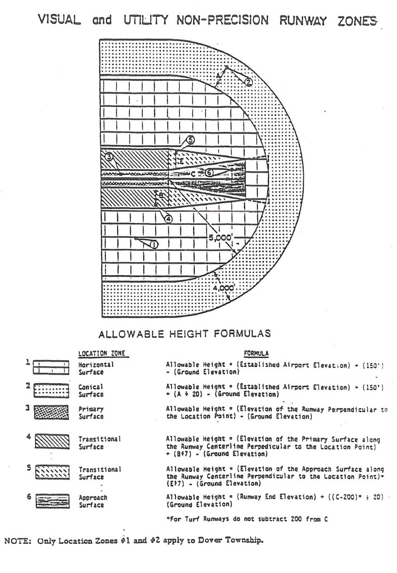
15. Maximum Allowable Height. The following figure and formulas have been prepared for determining the maximum allowable heights of objects within the airport's vicinity. The formulas are used in conjunction with the figure; where a formula is assigned a number, that formula corresponds with a point location of the same number on the figure. By using the formulas and following the steps outlined below, the maximum allowable height at a point location can be determined.
A. Locate the point (object) in question on the figure (sample point locations identified by numbers are given in various coded airport zones).
B. Apply the formula having the same number as the chosen point location to calculate the maximum allowable height for an object at that point (some formulas will have letter variables (e.g., “A”) shown on the figure).
(Ord. 2015-06, 9/28/2015)