Loading...
2. Type 2 Administrative Decisions:
A. Allowed Use with Allowed Form:
(1) Applicability: This procedure applies to all applications for an Allowed Use, as shown in Table 11-03.1: Table of Allowed Uses that meets all applicable Use-Specific Form Standards and therefore has an Allowed Form applicable to the Allowed Use.
(2) Procedure:

(3) Findings for Approval: The Planning Director shall approve the application, or approve it with conditions, if it complies with the criteria in Section 11-05-04.6.A(3)(a), Decision by Planning Director, City Official, or Hearing Examiner including but not limited to the applicable Use-Specific Standards for that use, and specifically including those Use-Specific Form Standards (the Allowed Form) applicable to the Allowed Use in the zoning district in which it is located.
B. Alternative Sign Plan:
(1) Applicability: This procedure applies to all applications for approval of an Alternative Sign Plan pursuant to Section 11-04-012.8.
(2) Procedure:

(3) Findings for Approval: The Planning Director shall approve the application, or approve it with conditions, if:
(b) It will not create material distractions or confusion that could materially impact traffic safety; and
(c) It will not materially increase visual clutter when viewed from adjacent streets, parks, open spaces, and Residential zoning districts, or any material impact to visual clutter have been mitigated to the maximum extent practicable.
C. Certificate of Appropriateness - Minor:
(1) Applicability:
(a) General: Within any HD-O district, the following provisions shall apply unless an exception to these provisions is shown in Subsection (b) below;
i. No building, site, structure, or exterior feature of any building, site, structure, or object (including, but not limited to, walls, pavement, or other appurtenant features), above ground utility structure, trees removed or substantially modified, or any type of sign shall be erected, altered, restored, moved, or demolished within such district until after an application for a Minor Certificate of Appropriateness has been approved by the Planning Director or the HPC.
ii. A Minor Certificate of Appropriateness shall be required whether or not a Building Permit is required, and before any other application under this Code may be approved for the property in question.
iii. The Minor Certificate of Appropriateness process shall apply to each activity identified in Subsection i. above that is identified as eligible for review and decision by the Planning Director in the Certificate of Appropriateness Matrix of major and minor historic preservation actions adopted by resolution by the City Council on recommendation from the HPC and on file in the Planning and Development Services Department and available on the City's website.
(b) Exceptions:
i. No Certificate of Appropriateness is required for the following items:
A. Interior arrangement of any building or structure;
B. Installation of temporary structures and features that do not remain in existence for more than 45 days in any consecutive 12 month period.
C. A site or building improvement that does not require a Certificate in the Certificate of Appropriateness Matrix as adopted by resolution by the City Council and on file in the Planning and Development Services Department and available on the City's website.
ii. If an application that is eligible for review as a Minor Certificate of Appropriateness will also require a Variance, it shall be reviewed as a Major Certificate of Appropriateness.
(2) Procedure:

(3) Findings for Approval: The Planning Director shall approve, or approve with conditions, the application if the Planning Director, after consideration of the factors listed in Section 11-05-05.3.B(3), Findings for Approval, as applicable, determines that the proposed activity will not create a material negative impact on the historic character of the HD-O district in which the property is located, and that any minor impacts have been mitigated to the maximum extent practicable.
D. Conditional Use - Minor Expansion:
(1) Applicability: This procedure applies to all applications for approval to:
(a) Expand an approved conditional use by less than 20 percent of the approved gross floor area or site area;
(b) Reduce the project density by up to 25 percent of the total units;
(c) Relocate dwelling units or building pads for some practical reason such as road alignment, topography, access, solar access, or stability in hillside areas;
(d) Modify the phasing Plan;
(e) Modify the recreation area or open space design that will not eliminate or significantly reduce these areas;
(f) Increase or decrease in the proposed setbacks that comply with Code standards; and
(g) Modify building elevations.
(2) Procedure:

(b) In addition to the Interdepartmental Review that may be required by the Planning Director pursuant to Section 11-05-04.3.C prior to submittal of an application, the Planning Director may require an Interdepartmental Review of the application after the completeness of an application has been confirmed pursuant to Section 11-05-04.4.
(3) Findings for Approval: The Planning Director shall approve the application, or approve it with conditions, if it complies with the criteria in Section 11-05-04.6.A(3)(a), Decision by Planning Director, City Official, or Hearing Examiner and with the following criteria:
(a) The location and design of the proposed use is compatible to other uses in the surrounding area; and
(b) The proposed expansion will not create any material negative impacts to uses in the surrounding area, or any material negative impacts will be mitigated to the maximum extent practicable.
E. Design Review - Minor:
(1) Applicability:
(a) General: This procedure applies to all applications for Minor Design Review approval unless exempted pursuant to Subsection (b) below:
i. A commercial or mixed-use building not exceeding 5,000 square feet gross floor area that is not on a lot abutting a Residential zoning district or residential use;
ii. An industrial building not exceeding 10,000 square feet gross floor area that is not on a lot or parcel abutting a residential zoning district or a residential use;
iii. A residential development of less than 50 dwelling units;
iv. Surface parking lots;
v. Signs;
vi. Demolition of structures (excluding uninhabited accessory structures); and/or
vii. A Modification meeting the standards set forth in Section 11-05-04.7.B(1)(b)ii.
(b) Exceptions:
i. Single-Family Detached, Single-Family Attached, Duplex, Triplex, and Fourplex Dwellings are exempted from the requirements of this Section, unless they are required to comply pursuant to Section 11-04-03.4, Residential Small Lots.
ii. Installation of the following:
A. Building additions or accessory buildings less than 200 square feet;
B. Roof and fascia changes;
C. Minor parking lot revisions;
D. Minor repairs that do not result in discernable changes; and/or
E. Repainting of approved parking stalls.
(c) Applications that are not required to complete Minor Design Review are still required to comply with applicable design standards in Section 11-04-06, Building Design.
(2) Procedure:
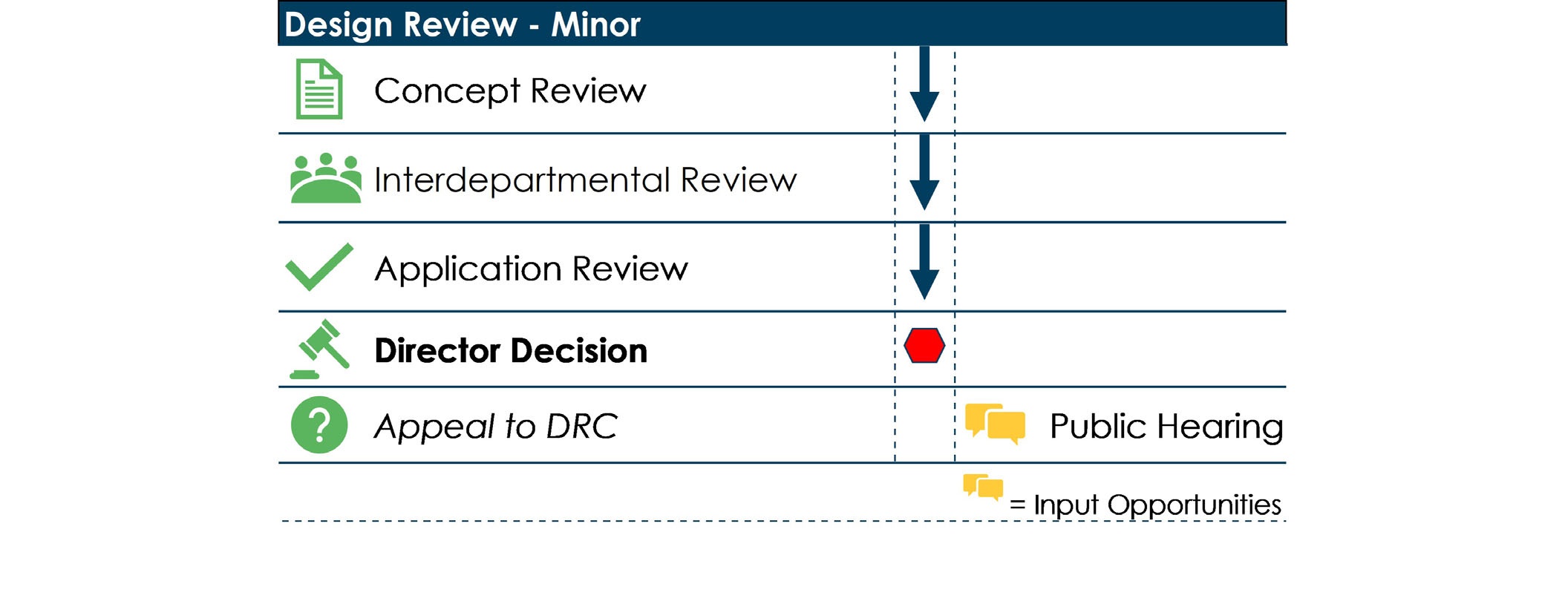
(b) The Planning Director shall determine whether the application is categorized as requiring Minor or Major Design Review.
(c) For those applications that require Minor Design Review pursuant to Section 11-05-05.2.E, a separate application for a Zoning Certificate shall not be required and compliance with the applicable use standards shall be reviewed as a part of the Minor Design Review approval.
(3) Findings for Approval:
The Planning Director shall approve, or approve with conditions, the application if it complies with the criteria listed in Section 11-05-04.6.A(3)(a), Decision by Planning Director, City Official, or Hearing Examiner.
F. Floodplain Permit:
(1) Applicability:
(a) A Floodplain Permit is required for all development within the Flood Protection Overlay district (FD-O) as described in Section 11-02-07.3.F(1)(c), Applicability.
(b) Compliance with the standards in this Code shall not relieve any person of the independent obligation to comply with all applicable standards and practices established in federal and state law and all other applicable rules, regulations, standards, and specifications of the City regarding development within a floodplain.
(2) Procedure:

(b) The application shall be processed concurrently with other related development applications for the same project.
(3) Findings for Approval: The Planning Director shall approve the application, or approve it with conditions, after consultation with the Floodplain
G. Legal Nonconformity - Confirmation, Change, or Minor Expansion:
(1) Applicability:
(a) This Section applies to:
i. All applications by a property owner to confirm the legal nonconforming status of an existing parcel, use, or building;
ii. All applications by a property owner to expand a legal nonconforming use or building by less than 20 percent of the gross floor areas at the time the use became nonconforming;
iii. All applications by a property owner to change a legal nonconforming use to a different legal nonconforming use; and
iv. All requests by the Planning Director to have a property owner provide evidence of the legal nonconforming status and existing use.
(b) Applications for an expansion of a legal nonconforming use or building by 20 percent or more shall be subject to the standards set forth in Section 11-05-05.3.G, Legal Nonconformity - Major Expansion.
(2) Procedure:

(b) Regardless of whether the property owner or the Planning Director has requested confirmation of the legal nonconforming status of a property, the property owner shall be required to provide evidence of the date on which the parcel, structure, use, sign, or site feature was first created or established. Evidence may include but is not limited to utility records, photographs, assessor's records, rental receipts, phone directories, notarized statements, and Polk Directories.
(c) If the Planning Director determines that the legal nonconforming status has been demonstrated by the property owner, the Planning Director shall issue a Zoning Compliance Review documenting the legal nonconforming status.
(d) If the property owner does not provide evidence or the Planning Director determines that the evidence presented does not demonstrate legal nonconforming status of the parcel, structure, use, sign, or site feature, the Planning Director shall mail the property owner a notice that the property does not have legal nonconforming status. The notice may also identify what portions or aspects of the property may be violations of this Code and what is required to bring the property into compliance with this Code.
(3) Findings for Approval:
(a) The Planning Director shall approve or approve with conditions the application for confirmation of a legal nonconforming use or building if the Planning Director determines that the use or building that is the subject of the application was legal when the use was begun or the building was constructed, and has become nonconforming since that time due to the actions of a government agency, including but not limited to an amendment to this Code or another government regulation, and not due to the actions of the current or prior owner of the property.
(b) The Planning Director shall approve or approve with conditions a change of a legal nonconforming use to different legal nonconforming use if the new use:
i. Will not unduly burden transportation or service facilities in the vicinity and does not adversely impact the delivery of services by any political subdivision providing services;
ii. Will not result in material negative impacts to surrounding properties; or that any deviation from those criteria has been mitigated to the maximum extent practicable;
iii. Will be no greater in intensity, impacts, and demand for services than the existing legal nonconforming use; and
iv. Will not be in conflict with the Comprehensive Plan;
(c) The Planning Director shall approve or approve with conditions an expansion of a legal nonconforming use or building by up to 20 percent beyond the area of the building or parcel occupied by the legal nonconforming use or the building on the date it became legally nonconforming, if:
i. The expansion will not unduly burden transportation or service facilities in the vicinity and does not adversely impact the delivery of services by any political subdivision providing services;
ii. The expansion will not result in material negative impacts to surrounding properties or that any deviation from those criteria has been mitigated to the maximum extent practicable;
iii. Any expansion of a legal nonconforming building will conform to the applicable sections of this Code and will not increase the degree of nonconformity of that part of the building that does not meet the provisions of this Code; and
iv. The expansion will not be in conflict with the Comprehensive Plan.
H. Planned Unit Development Modification - Minor:
(1) Applicability:
(b) For Planned Unit Developments approved prior to the Effective Date, modifications shall be reviewed through the Conditional Use Minor Expansion process pursuant to Section 11-05-05.2.D.
(2) Procedure:

(3) Findings for Approval: The Planning Director shall approve, or approve with conditions, the application if it complies with the required Findings for Approval for a Minor Design Review in Section 11-05-05.2.E(3) or for a Zoning Certificate in Section 11-05-05.2.M(3), as applicable to the proposed modification.
I. Reasonable Accommodation for Accessibility:
(1) Applicability: This procedure shall apply to each request to deviate from the standards in this Code to provide Reasonable Accommodation for a person experiencing disabilities as defined in the federal Fair Housing Amendments Act, as amended and interpreted by the courts.
(2) Procedure:

(a) Any ADA accommodation that is medically necessary and cannot satisfy the zoning code requirements may request additional review and approval prior to a zoning approval being issued.
(b) Any ADA accommodation that is not medically necessary and cannot satisfy the zoning code requirements shall be treated as a variance and shall file a variance application.
(3) Findings for Approval:
(a) No such accommodation shall encroach or be located within a public right-of-way.
(b) Such ADA accommodation for residential use shall refer to the adopted Building Code for construction guidance to ensure safe assembly, heights, distances, entry access and slope.
(c) The Planning Director shall approve the application, or approve it with conditions, after consultation with the City Attorney and other applicable parties, determines that approval of the Fair Housing Reasonable Accommodation is required to comply with the provisions of the Federal Fair Housing Amendments Act.
J. Record of Survey:
(1) Applicability: A Record of Survey is required for the following:
(a) A Property Line Adjustment that establishes or modifies the boundaries of buildable parcels with boundaries that differ from existing buildable parcels and/or buildable lot boundaries;
(b) A Parcel Consolidation that combines two or more existing, contiguous buildable parcels into one buildable parcel; and
(c) A Minor Land Division.
(2) Procedure:

(b) Evidence of recordation of a notice of buildable parcel with the City Clerk and Ada County Recorder is required before a Building Permit may be issued.
(3) Findings for Approval: The Planning Director shall approve the application, or approve it with conditions, if it complies with the criteria in Section 11-05-04.6.A(3)(a), Decision by Planning Director, City Official, or Hearing Examiner, including, but not limited to, the applicable standards set forth in Section 11-04-04.3, Records of Survey.
K. Residential Small Lot Approval - Minor:
(1) Applicability: This procedure applies to all applications subject to the Residential Small Lot standards in Section 11-04-03.4 that contain four or fewer dwelling units on up to four contiguous Residential Small Lots.
(2) Procedure:

(3) Findings for Approval: The Planning Director shall approve the application, or approve it with conditions, if it complies with the criteria in Section 11-05-04.6.A(3)(a), Decision by Planning Director, City Official, or Hearing Examiner, including but not limited to the applicable standards set forth in Section 11-04-03.4, Residential Small Lots.
L. River System Permit - Minor:
(1) Applicability: A Minor River System Permit is required for all lands and waters and all aquatic, wetland, riparian, and upland environments within the jurisdiction of Boise City that lie:
(a) Within the 100 year Floodplain boundaries adjacent to the Boise River; or
(b) Within the Setback Lands and Waters as described in Section 11-02-07.3.E(6), Setbacks; or
(c) Within Class A, Class B and Class C areas as described in Section 11-02-07.3.E(5), A, B, And C Lands and Waters Classifications; and that
(d) Do not affect more than 100 lineal feet of river bottom or bank, nor more than one-half acre of Class A or B lands;
(e) Do not materially alter, fully restores, or enhances the existing surface and groundwater hydrology, soils, plant and animal communities and habitats present within or adjacent to the project; and
(f) Provide for the maintenance of storm water detention/sedimentation basins and stabilization structures.
(2) Procedure:

(b) In addition to that Interdepartmental Review that may be required by the Planning Director pursuant to Section 11-05-04.3.C prior to submittal of an application, the Planning Director may require an Interdepartmental Review of the application after the completeness of an application has been confirmed pursuant to Section 11-05-04.4.
(c) The application shall be reviewed concurrently with all other applications required for approval of the specific development proposed for the property.
(3) Findings for Approval: The Planning Director shall approve the application, or approve it with conditions, if it complies with the criteria in Section 11-05-04.6.A(3)(a), Decision by Planning Director, City Official, or Hearing Examiner and with the following criteria:
(a) The proposed development complies with the applicable standards for Uses in Class A, B or C lands and waters in Section 11-02-07.3.E(5), A, B, And C Lands and Waters Classifications.
(b) The proposed development complies with all standards in Section 11-02-07.3.F, FP-O Flood Protection Overlay applicable to the property.
(c) The proposed development is not in conflict with the Comprehensive Plan and complies with all the policies and standards of the Boise River Plan.
(d) The proposed development includes measures designed to ensure that natural resources functions and values are preserved or enhanced and maintained.
(e) The proposed development complies with all local, state, and federal laws and regulations.
M. Zoning Certificate:
(1) Applicability:
(a) A Zoning Certificate is required for any use that:
i. Does not require a Conditional Use Permit or Design Review approval;
ii. Is not listed separately as a Type 2 application; and
iii. Only requires review by the Planning Director to confirm compliance with the applicable standards of this Code. This category includes but is not limited to applications for approval of a mural, Sidewalk Café, Accessory Dwelling Unit, a Duplex, Triplex, or Fourplex Dwelling, or an Adult or Child Day Care Facility.
(b) A Zoning Certificate is also required prior to demolition of the following:
i. Any primary structure containing a primary Multiple-Family Dwelling or a Public, Institutional, and Civic, Commercial, or Industrial use as described in Table 11-03.1: Table of Allowed Uses.
ii. Any non-accessory residential structure completed more than 50 years ago.
(c) Any request for demolition addressed in Subsection (b) above that is not accompanied by an application for a replacement structure shall be reviewed for compliance with the applicable Sections of Chapter 11-04, Development and Design Standards.
(2) Procedure:

(b) For those applications that require Minor Design Review pursuant to Section 11-05-05.2.E, a separate application for a Zoning Certificate shall not be required and compliance with the applicable Design Review standards shall be reviewed as a part of the Minor Design Review.
(3) Findings for Approval: The Planning Director shall approve the application, or approve it with conditions, if it complies with the criteria in Section 11-05-04.6.A(3)(a), Decision by Planning Director, City Official, or Hearing Examiner and that all applicable Minor Design Review criteria set forth in Section 11-05-05.2.E(3) have been met.
3. Type 3 Decisions by an Appointed Body:
A. Allowed Use with Alternative Form:
(1) Applicability: This procedure applies to all applications for an Allowed Use, as shown in Table 11-03.1: Table of Allowed Uses that comply with all Use-Specific Standards for the use, except that they do not meet one or more of Use-Specific Form Standards applicable to the Allowed Use in the zoning district that they are located in and therefore are proposing an Alternative Form for approval.
(2) Procedure:

(b) The review of the PZC shall be limited to consideration of the proposed Alternative Form of the proposed development and shall not consider or attach conditions to the use, operation, or activities within the proposed development.
(3) Findings for Approval: The PZC shall approve the Alternative Form for the Allowed Use, or approve it with conditions, if it determines that at least one of the following criteria have been met:
(a) The Alternative Form will promote the urban design goals of the Comprehensive Plan and other approved plans applicable to the property as well or better than compliance with all Use-Specific Form Standards applicable to the Allowed Use;
(b) The Alternative Form is needed because the use and design of adjacent developed properties makes it impracticable to comply with the one or more of the Use-Specific Form Standards; or
(c) If the Alternative Form includes a reduction in the required minimum height of the building:
i. The reduced height of the building will still provide an adequate sense of street enclosure and an adequate level of residential or nonresidential activity from the building to promote the goals of the Comprehensive Plan and other applicable plans for the property; or
ii. The reduced height of the building, and any resulting reduction in the size of the building will not result in the underdevelopment of the site or the inefficient use of City facilities and infrastructure.
B. Certificate of Appropriateness - Major:
(1) Applicability:
(a) General: Within any HD-O district, the following provisions shall apply, unless an exception to these provisions is shown in Subsection (b) below.
i. No building, site, structure, or exterior feature of any building, site, structure or object (including, but not limited to, walls, pavement or other appurtenant features), above ground utility structure, trees removed or substantially modified, or any type of sign shall be erected, altered, restored, moved or demolished within such district until after an application for a Minor or Major Certificate of Appropriateness has been approved by the Planning Director or the HPC.
ii. A Major Certificate of Appropriateness shall be required whether or not a Building Permit is required, and before any other application under this Code may be approved for the property in question.
(b) Exceptions:
i. No Certificate of Appropriateness is required for the following items:
A. Interior arrangement of any building or structure; and
B. Installation of temporary structures and features that do not remain in existence for more than 45 days in any consecutive 12 month period;
C. A site or building improvement that does not require a Certificate in the Certificate of Appropriateness Matrix as adopted by resolution by the HPC and on file in the Planning and Development Services Department.
ii. An application for a Major Certificate of Appropriateness may include a request for a Variance pursuant to Section 11-05-05.3.L(1), Applicability.
(2) Procedure:

(b) If an alteration, demolition, or relocation that requires a Certificate of Appropriateness occurs prior to the issuance of a Certificate of Appropriateness for that action, the Planning Director shall, within 180 days, prepare a premature alterations report. The report shall identify any violations of Section 11-05-05.3.A and recommends rehabilitative measures, if any. The Planning Director shall provide the premature alterations report to the applicant and the relevant Registered Neighborhood Association and applicant. Upon issuance of the report, the Planning Director shall negotiate with the applicant, relevant Registered Neighborhood Association, and other affected parties in an effort to find a means of restoring the property to its original condition. Thereafter, but in no event to exceed 180 days from the issuance of the premature alterations report, the Planning Director shall provide to the Historic Preservation Commission a final report incorporating findings, recommendations, comments, and any other information. Pursuant to its grant of power under Idaho Code Section 67-4604 and Section 11-05-03.5.A, Duties, Jurisdiction, and Authority, the Commission may adopt, adopt with modifications, or deny the findings and recommendations of the final premature alterations report.
i. The premature alterations procedure, including the preparation of the report and negotiations, may be waived at the discretion of the Planning Director at any time.
ii. During a review of a premature alteration, all work at the subject property, including further alterations, demolitions, relocations, construction, or modifications of any kind, shall cease until the final premature alterations report is adopted, or adopted with modifications. If denied by the Commission work on the property shall remain stopped until resolved either by further action of the Commission or appeal to the City Council.
(c) The HPC shall schedule a public hearing and 15 calendar days prior to the hearing, notice shall be mailed to the applicant, adjacent property owners and residents (including tenants), and to the Registered Neighborhood Association.
(d) If the HPC determines that the findings for approval in Subsection (3) have not been met, it shall place upon its records the reason for such determination and shall notify the applicant in writing of its reasons and recommendations, if any, as to what actions could be taken in order to obtain a certificate.
(e) The decision is deemed to have been made on the date that the HPC adopts written findings of fact and conclusions of law.
(3) Findings for Approval: The HPC shall approve the application, or approve it with conditions, if the following criteria have been met:
(a) General Findings:
i. Plans and Guidelines: The design of the project is consistent with the following plans and guidelines as applicable to the property:
A. 1993 Downtown Boise Plan;
B. Urban Renewal Plans;
C. Design Guidelines for Residential Historic Districts;
D. Boise City Historic Preservation Plan (dated July 1979);
E. The Secretary of the Interior's Standards for the Treatment of Historic Properties with Guidelines for Preserving, Rehabilitating, Restoring and Reconstructing Historic Buildings (The Secretary of the Interior's Standards);
F. A Field Guide to American Houses by Virginia and Lee McAlester;
G. American Vernacular Design 1870-1940 An Illustrated Glossary by Herbert Gottfried and Jan Jennings; and
H. Design Guidelines for Commercial Historic Districts with the Secretary of the Interior's Standards for Historic Preservation August 2009.
ii. Site Design: The application shall be reviewed by the HPC, with input from other agencies, to evaluate the site design, and to determine compatibility and impact both on and adjacent to the site as it relates to access, parking lot design, landscaping, grading and storm drainage, and other development of the site. The HPC's decision with regards to site design shall be based upon the following findings as they relate to historic preservation:
A. Traffic Impact, Pedestrian and Bicyclist Provisions: That the site provides a safe, convenient, and efficient network that minimizes conflicts between pedestrians, bicyclists, and vehicular traffic by creating a network that includes sidewalks, pathways, landscaping that promotes and supports active transportation and does not adversely impact the delivery of services by any political subdivision providing services.
B. Landscaping: That the proposed landscaping enhances the Historic District and neighborhood with attributes that include but are not limited to protection of desirable existing trees, provision of street trees, and adequate screening methods where needed to buffer adjacent uses and unsightly areas or features.
C. On-Site Grading and Drainage: That on-site grading and drainage have been designed so as to minimize off-site impact and provide for erosion control as required by the Public Works Department, Ada County Highway District and/or other jurisdictional agencies.
D. Utility Service Systems: That utility service systems and equipment do not detract from the building design or adjacent buildings, and the size and location of all service systems are appropriate and maintainable.
iii. Structure Design: The design of all proposed buildings shall be reviewed in accordance with the Design Guidelines for Commercial Historic Districts Design Guidelines for Residential Historic Districts, on file in the Planning and Development Services Department and available on the City's website, as well as the following findings:
A. Building Mass: That the mass of the building is reviewed for its relationship and consistency to other buildings within the Historic District and area, and with the use proposed by the applicant.
B. Proportion of Building Façades: That the height to width relationship shall be compatible and consistent with the predominant architectural character of the Historic District.
C. Shadow Relief/Design Interest: That the exterior of the building provides shadow relief and design interest compatible with the architectural character of the area.
D. Relationship of Exterior Materials: That the appropriateness of materials and colors (paint colors are only reviewed in commercial Historic Districts) shall be reviewed as they relate to building mass, shadow relief and compatibility with other buildings within the Historic District and area.
E. Multiple-Family Buildings: That any Multiple-Family building is designed to include features that add to the visual and aesthetic appearance of the structure and help prevent a sterile, box-like appearance. Such features may include the use of brick or stone, roof or façade modulation, planter boxes, bay windows, balconies, or porches. Specific design features have been added to enhance the physical appearance of such Multiple-Family residential structures.
F. Commercial/Industrial Buildings Adjacent to Residential Uses: That the building is designed to minimize impacts on adjacent residential uses and/or Residential zoning districts.
(b) Findings for Alterations: In addition to the general findings in Subsection (a) above, an application for the alteration of an existing building shall only be approved or approved with conditions if the HPC finds that the application:
i. Is consistent with the Design Guidelines for Commercial Historic Districts or Residential Historic Districts and that based on the Guidelines, the request will not be incongruous with the historical, architectural, archeological, educational, or cultural aspects of the district;
ii. Is consistent with the Secretary of the Interior's Standards for Rehabilitation, or other standards as applicable (preservation, restoration, or reconstruction);
iii. Complies with the dimensional standards and other applicable requirements of this Code including, but not limited to, setbacks, height restrictions and parking requirements unless the HPC finds that modifying those standards is necessary to protect the overall characteristics of the district and to comply with the adopted Design Guidelines; and
iv. Will not be in conflict with the Comprehensive Plan
(c) Findings for Signs: In addition to the general findings in Subsection (a) above, an application for a sign shall only be approved if the HPC finds that the sign will be congruous with the building in design, materials, size, and location.
(d) Findings for Demolitions or Relocations:
i. If the application involves the demolition or relocation of a structure, in addition to the general findings in Subsection (a) above, the HPC shall find that at least three out of the five following criteria have been met:
A. The building, site, structure, or object is not classified as contributing within the district as stated on the survey form on file in the Planning and Development Services Department;
B. The building, site, structure, or object cannot reasonably meet national, state, or local criteria for designation as an historic property;
C. Demolition of the building, site, structure, or object would not have an adverse impact on the character of the district and/or the adjacent properties;
D. The owner has reasonably demonstrated that rehabilitation of the building, site, structure, or object would not be economically practical, realistic, or viable based on review of the information required in the application provided by the applicant at the time the request for a Certificate of Appropriateness is submitted; and
E. Plans have been submitted to redevelop the property if the demolition proceeds and such plans will have a positive effect on the district and/or adjacent properties. The size, scale, use, materials, and/or overall design of the project may be considered as qualities for producing a positive effect.
ii. If the HPC has approved a partial demolition and approved the replacement structure and the plans for the replacement structure remain the same, and the Building Official later determines in writing that a full demolition is necessary for life safety and there are no other cost-effective alternatives, the Planning Director may approve the full demolition.
(e) Findings for Change in Use: If the application requests a change of use, in addition to the general findings in Subsection (a) above, the HPC shall find that the following criteria have been met:
i. That the request will not be in conflict with the Comprehensive Plan and supports the goals, objectives, and policies of the applicable neighborhood plans; and
ii. That the request will be congruous with the historical, architectural, archeological, educational, or cultural significance of the district.
(f) Findings if a Request for Variance is Included: An application for a Certificate of Appropriateness may be combined with an application for a Variance pursuant to Section11-05-05.3.L, and both applications may be reviewed and a decision made by the HPC after a single public hearing, provided that the decision on the Variance application shall be based on the findings for approval in Section 11-05-05.3.L(3).
C. Conditional Use Permit - Initial Approval or Major Expansion:
(1) Applicability:
(a) A Conditional Use Permit is required for any use that is classified as a Conditional Use in Table 11-03.1: Table of Allowed Uses and for a Major Expansion of an approved conditional use permit. A Major Expansion of an approved conditional use permit includes but is not limited to:
i. An increase in density;
ii. A density decrease exceeding 25 percent of the total units that has been approved through a Conditional Use Permit;
iii. Any change that will impact the neighborhood, such as a significant change in traffic generation or flow;
iv. A change that was the subject of an appeal during the public hearing;
v. A change that would affect some other condition such as a condition regarding pathways, streets, schools, floodplain, or foothills;
vi. A request for a greater than 20 percent increase in building square footage;
vii. A request to change the nature of the approved use;
viii. A request to change or delete a condition of approval; and
ix. A request that would increase or cause impacts to a foothill or river area, or an increase in soil erosion.
(b) No conditional use shall be conducted except in compliance with all applicable provisions of this Code and with any conditions upon such Conditional Use Permit approval.
(2) Procedure:

(b) An application for a Conditional Use Permit may be combined with an application for a Variance pursuant to Section 11-05-05.3.L, and both applications may be reviewed and a decision made by the PZC after a single public hearing, provided that the decision on the Variance application shall be based on the findings for approval in Section 11-05-05.3.L(3).
(c) The PZC may extend the review and processing period for Conditional Use Permit applications. This extended review period is to allow for adequate staff research and analysis, agency review and comment, coordination with other City departments, and coordination with the applicant.
(d) In addition to those types of conditions listed in Section 11-05-04.6.A(4), Conditions, the PZC may attach additional conditions to the approval of a Conditional Use Permit, including but not limited to the following types of conditions:
i. Requiring more restrictive standards than those generally required in an ordinance;
ii. Conformity to approved plans and specifications;
iii. Provision of open spaces, pathways, buffer strips, walls, fences, landscaping, and lighting;
iv. Maximum volume of traffic generated, requirements for off-street parking, service drive design, construction standards, vehicular and pedestrian movements within the site, and points of ingress and egress;
v. Performance characteristics related to noise, vibration, and other potentially dangerous or objectionable elements;
vi. Limits on hours of operation;
vii. The period of time for which a permit is issued;
viii. The sequence and timing of the development;
ix. Guarantees as to compliance with the terms of the permit;
x. Number, location, color, size, height, lighting, use of outdoor areas, and landscaping of outdoor signs and structures;
xi. Requiring the provision for on-site or off-site public facilities or services, including the installation of street lights in accordance with the requirements of the Public Works Department;
xii. Requiring irrigation or drainage facilities to be covered or fenced for public safety.
(e) Conditions applied by the PZC shall not restrict or specify the exterior detail or design, color, or materials, except if such detail is of such magnitude as to affect the general appearance and compatibility of the development with its surroundings.
(3) Findings for Approval:
(a) General: Unless Subsection (b) below applies, the PZC shall approve the application or approve it with conditions if it complies with the criteria in Section 11-05-04.6.A(3)(b), Decision by Appointed Body or City Council and the following criteria:
i. The proposed location is uniquely suited to accommodate the proposed use or is a location for the proposed use supported by the Comprehensive plan or other adopted plan of the City;
ii. The proposed use will not create any material negative impacts to uses in the surrounding area, or any material negative impacts will be mitigated to the maximum extent practicable, and the public benefits of the proposed use outweigh any material negative impacts of the proposed use that cannot be mitigated;
iii. The site is large enough to accommodate the proposed use and all yards, open spaces, pathways, walls, fences, parking, loading, landscaping, and other such features as are required by this Code;
iv. The site provides a safe, convenient, and efficient network that minimizes conflicts between pedestrians, bicyclists, and vehicular traffic by creating a network that includes sidewalks, pathways, landscaping that promotes and supports active transportation and does not adversely impact the delivery of services by any political subdivision providing services;
v. The proposed use is not in conflict with the Comprehensive Plan; and
vi. If the application is combined with an application for a Variance, the findings for approval of the requested Variance in Section 11-05-05.3.L have been met.
(b) Reduction in Required Parking Greater than 50 Percent: If the application is to reduce the minimum required vehicle parking by more than 50 percent below that required by Table 11-04.9: Off-Street Parking Requirements, the PZC shall approve the application or approve it with conditions if it complies with the criteria in Section 11-05-04.6.A(3)(b), Decision by Appointed Body or City Council, and the following criteria:
i. The parking reductions offered in Section 11-04-08.7, Parking Adjustments, have been incorporated into the site design to the maximum extent practicable;
ii. The proposed reduction is uniquely suited to accommodate the proposed use or is a location for the proposed use supported by the Comprehensive plan or other adopted plan of the City;
iii. The proposed reduction will not create any material negative impacts to uses in the surrounding area, or any material negative impacts will be mitigated to the maximum extent practicable and the public benefits of the proposed use outweigh any material negative impacts of the proposed use that cannot be mitigated;
iv. The site provides a safe, convenient, and efficient network that minimizes conflicts between pedestrians, bicyclists, and vehicular traffic by creating a network that includes sidewalks, pathways, landscaping that promotes and supports active transportation and does not adversely impact the delivery of services by any political subdivision providing services; and
v. The proposed reduction is not in conflict with the Comprehensive Plan.
D. Design Review - Major:
(1) Applicability:
(a) Compliance Required: A Major Design Review application is required for each of the following, unless listed as an action that can be approved as a Minor Design Review application under Section 11-05-05.2.E or exempted by Subsection (b) below:
i. Any visible exterior improvement or alteration to a site, building, or structure, including demolitions;
ii. Any development in the CD-O district that meets the criteria set forth in Section 11-02-07.2.D(4), Design Review Permit; and
iii. Any development in the HD-O district that is also subject to the Citywide or Downtown Design Standards and Guidelines, on file in the Planning and Development Services Department and available on the City's website. If the Citywide or Downtown Design Standards and Guidelines conflict with the Historic Preservation Guidelines, the Historic Preservation Guidelines shall prevail.
(b) Exceptions:
ii. Installation or modification of the following:
A. Building additions or accessory buildings less than 200 square feet;
B. Replacement of approved roof and fascia;
C. Minor parking lot revisions;
D. Minor repairs that do not result in discernable changes; and
E. Repainting of approved parking stalls.
iii. Applications that are not required to complete Minor Design Review or Major Design Review are still required to comply with applicable design standards in Section 11-04-06, Building Design.
(2) Procedure:

(b) The Planning Director shall determine whether the application is categorized as requiring Minor or Major Design Review.
(c) Applications that are for new buildings or building additions greater than 200 square feet shall be prepared by, or under the direct supervision of, a duly licensed architect who shall be clearly identified on such designs, unless exempted under Idaho Code, Section 54-306.
(d) If a Design Review application requires associated approvals by the PZC or City Council, such as a Conditional Use Permit or Planned Unit Development, those approvals shall be obtained before an application for Design Review approval may be processed.
(e) The Planning Director may extend the review/processing period for Major Design Review applications. This extended review period is to allow for adequate staff research and analysis, agency review and comment, coordination with other City departments, and coordination with the applicant.
(f) Except for development on Residential Small Lots, the DRC shall not require reductions in height, density, floor area ratio, or other regulations included in Table 11-04.2: Residential District Dimensional Standards and Table 11-04.3: Mixed-Use, Industrial, and Open Land District Dimensional Standards, unless required for reasons public safety, reasonable accommodation, or health.
(3) Findings for Approval: The DRC shall approve the application, or approve it with conditions, if it complies with the following criteria.
(a) Site Design:
i. The site provides a safe, convenient, and efficient network that minimizes conflicts between pedestrians, bicyclists, and vehicular traffic by creating a network that includes sidewalks, pathways, landscaping that promotes and supports active transportation.
ii. The landscaping promotes well-conceived and attractive landscaping that will retain and protect existing vegetation where possible, enhance environmental conditions of the Treasure Valley, reduce potential impacts between adjacent and neighboring uses, and screen and conceal utilities, mechanical units, and services areas.
iii. The on-site grading and drainage are designed to minimize off- site impact and provide for erosion control.
iv. Signs minimize visual clutter.
v. Utility systems do not detract from building design and their size and location are appropriate and maintainable.
(b) Structure Design:
i. The building mass is appropriately designed to address the street and create a pedestrian-friendly environment.
ii. The design employs façade articulation techniques that add visual interest to the pedestrian realm and reduce the perceived scale of large buildings.
iii. Openings in the building façade provide visual interest to the pedestrian and mitigate impacts of monotonous flat walls planes, blank wall areas and provide shadow relief.
iv. Exterior materials are high-quality materials that minimize maintenance cost and provide visual interest to the street. Locally sourced and sustainable materials are strongly encouraged.
v. The building design shall minimize impacts on adjacent Residential zoning districts and residential uses.
(c) Adopted Plans and Design Guidelines: The application complies with all adopted plans and design guidelines, including the Citywide and Downtown Design Standards and Guidelines, unless modified by conditions attached by the DRC to satisfy the required findings in Subsections (a) and (b) above.
E. Floodplain Variance:
(1) Applicability:
(a) A Floodplain Variance is required for all requests to vary the requirements of Section 11-02-07.3.F, FP-O Flood Protection Overlay.
(b) Floodplain Variances may generally be issued for new construction and substantial improvements to be erected on a lot of one-half acre or less in size that is contiguous to and surrounded by lots with existing structures constructed below the Base Flood Elevation.
(2) Procedure:

(b) In reaching a decision, the Hearing Examiner shall review:
i. The danger that materials may be swept onto other lands to the injury of others;
ii. The danger to life and property due to flooding or erosion damage;
iii. The susceptibility of the proposed facility and its contents to flood damage and the effect of such damage on the individual owner;
iv. The importance of the services provided by the proposed facility to the community; the necessity to the facility of a waterfront location where applicable;
v. The availability of alternative locations for the proposed use that are not subject to flooding or erosion damage;
vi. The compatibility of the proposed use with existing and anticipated development;
vii. The relationship of the proposed use to the Comprehensive Plan and floodplain management program for that area;
viii. The safety of access to the property in times of flood for ordinary and emergency vehicles;
ix. The expected heights, velocity, duration, rate of rise, and sediment transport of the flood waters, if applicable, expected at the site; and
x. The costs of providing governmental services during and after flood conditions, including maintenance and repair of public utilities and facilities including but not limited to sewer, gas, electrical, water systems, and streets and bridges.
(c) Any applicant to whom a Floodplain Variance is issued shall be given written notice that the cost of flood insurance may be commensurate with any increased flood risk.
(d) The Floodplain Administrator shall maintain a record of all Floodplain Variance actions, including justification for their approval.
(3) Findings for Approval:
(a) General: The Hearing Examiner shall approve a Floodplain Variance request, or approve it with conditions, if it complies with the criteria in Section 11-05-04.6.A(3)(a), Decision by Planning Director, City Official, or Hearing Examiner and the following criteria:
i. Floodplain Variances shall not be issued within any designated floodway if any increase in flood levels during the Base Flood discharge would result.
ii. A Floodplain Variance shall only be issued upon determination that the variance is the minimum necessary, considering the flood hazard, to afford relief.
iii. A Floodplain Variance shall only be issued upon a showing of good and sufficient cause, a determination that failure to grant the variance would result in exceptional hardship to the applicant; and a determination that the granting of a variance shall not result in increased flood heights, additional threats to public safety, extraordinary public expense, the creation of nuisances, degradation of or victimization of the public, or conflict with existing local laws or ordinances.
iv. The Floodplain Variance is consistent with the National Flood Insurance Program adoption of the general zoning law principles that:
A. They pertain to a physical piece of property;
B. They are not personal in nature;
C. They do not pertain to the uniqueness of the structure, its inhabitants, economic or financial circumstances;
D. They primarily address smaller lots in densely populated residential neighborhoods; and
E. They should be approved quite rarely.
v. Floodplain Variances for nonresidential buildings may be approved in very limited circumstances to allow a lesser degree of flood-proofing than watertight or dry-flood-proofing, where it can be determined that such action will have low damage potential, and otherwise complies with the standards in Sections 11-02-07.3.F(3)(b)i, Uses and 11-02-07.3.F(3)(b)ii, Utilities.
F. Hillside Development Permit - Category 3:
(1) Applicability:
(a) A Hillside Development Permit is required for any development proposal for properties when any topographical slope exceeds 15 percent or where adverse conditions associated with slope stability, expansion soils, high water table and springs, erosion or sedimentation are present as determined by the Planning Director or City Engineer.
(b) A Category 3 Hillside Development Permit is required for those projects defined in Section 11-02-07.3.G(3)(c).
(2) Procedure:

(b) A meeting with the Public Works Department shall be held after acceptance of the application.
(c) An application for a Category 3 Hillside Development Permit may be combined with an application for a Subdivision Plat or Planned Unit Development and both applications may be reviewed, and a recommendation made by the PZC to the City Council.
(3) Findings for Approval: The PZC shall approve the application, or approve it with conditions, if it complies with the criteria in Section 11-05-04.6.A(3)(b), Decision by Appointed Body or City Council and the following criteria:
(a) The proposed development complies with the technical requirements of Sections 11-02-07.3.G, HS-O: Hillside Development Overlay and 11-04-05.6, Foothills Development Standards if applicable including those related to grading, drainage, hazardous areas, revegetation, preservation of outstanding and unique features;
(b) If located in the FP-O district, the proposed development complies with all requirements of Section 11-02-07.3.F, FP-O Flood Protection Overlay.
(c) The land itself is capable of the volume and type of development proposed as determined by geological, hydrological and soils engineering analysis; and
(d) The project does not create a potential hazard of flooding, soil instability, fire, and erosion.
G. Legal Nonconformity - Major Expansion:
(1) Applicability: This procedure applies to all applications to expand a legal nonconforming use or building by 20 percent or more of the areas occupied at the time the use became legally nonconforming.
(2) Procedure:

(3) Findings for Approval: The PZC shall approve the application, or approve it with conditions, if it complies with the criteria in Section 11-05-04.6.A(3)(b), Decision by Appointed Body or City Council and the following criteria:
(a) The expansion will not unduly burden transportation or service facilities in the vicinity and does not adversely impact the delivery of services by any political subdivision providing services;
(b) Will not result in material negative impacts to surrounding properties; or that any deviation from those criteria has been mitigated to the maximum extent practicable and the public benefits of the proposed expansion outweigh any material negative impacts of the proposed expansion that cannot be mitigated;
(c) Any expansion of a legal nonconforming building will not increase the degree of nonconformity of that part of the building that does not meet the provisions of this Code; and
(d) The expansion will not be in conflict with the Comprehensive Plan.
H. Planned Unit Development Modification - Major:
(1) Applicability:
(a) This Section applies to applications for modifications to Planned Unit Developments approved after the Effective Date that the Planning Director determines are not eligible for approval as a Planned Unit Development Minor Modification pursuant to Section 11-05-05.2.H.
(b) For Planned Unit Developments approved prior to the Effective Date, modifications shall be reviewed through the Conditional Use Major Expansion process pursuant to Section 11-05-05.3.C.
(2) Procedure:

(3) Findings for Approval: The PZC shall approve the application, or approve it with conditions, if it complies with the required findings for approval for a Zoning Map Amendment pursuant to Section 11-05-05.4.I(2)(a)ii as applicable to a Planned Unit Development.
I. Reclassification of Historic Resource
(1) Applicability: This procedure applies to any application to change the classification of any building, site, structure, or object located within a designated Historic District from a non-contributing to a contributing property, or from a contributing to a non-contributing property, which action may occur on or after the 50th anniversary of its original construction.
(2) Procedure:

(b) The application shall be filed pursuant to a motion of the Historic Preservation Commission or at the request of the Planning Director, property owner, or an applicant with the written consent of the property owner,
(c) The HPC may reclassify a building, site, structure, or object within a designated HD-O district from non-contributing to contributing or from contributing to non-contributing.
(3) Findings for Approval: The HPC shall approve the application, or approve it with conditions, if it complies with the criteria in Section 11-05-04.6.A(3)(b), Decision by Appointed Body or City Council and the following criteria:
(a) A building, site, structure, or object may be reclassified from non-contributing to contributing or from contributing to non-contributing if the HPC determines that an error was made on the original survey.
(b) A building, site, structure, or object may be reclassified from contributing to non-contributing or from non-contributing to contributing if alterations, additions, or restorations have been made so that the classification prior to the change no longer reflects the proper classification after the change.
(c) If the HPC determines that a reclassification is justified pursuant to Subsections (a) or (b) above, the HPC shall also make the following findings in writing.
i. Whether or not the building, site, structure, or object is eligible for the National Register of Historic Places.
ii. Whether or not the building, site, structure, or object contributes to the HD-O district in which it is located.
J. Residential Small Lot Approval - Major:
(1) Applicability: This procedure applies to all applications subject to the Residential Small Lot standards in Section 11-04-03.4 that contain five or more dwelling units on five or more contiguous Residential Small Lots.
(2) Procedure:

(3) Findings for Approval: The DRC shall approve the application, or approve it with conditions, if it complies with the criteria in Section 11-05-04.6.A(3)(b), Decision by Appointed Body or City Council, including but not limited to the applicable standards set forth in Section 11-04-03.4, Residential Small Lots.
K. River System Permit - Major:
(1) Applicability: A Major River System Permit is required for all lands and waters and all aquatic, wetland, riparian, and upland environments within the jurisdiction of Boise City that lie:
(a) Within the 100 year Floodplain boundaries adjacent to the Boise River;
(b) Within the Setback Lands and Waters as described in Section 11-02-07.3.E(6), Setbacks; or
(2) Procedure:

(b) In addition to that Interdepartmental Review that may be required by the Planning Director pursuant to Section 11-05-04.3.C prior to submittal of an application, the Planning Director may require an Interdepartmental Review of the application after the completeness of an application has been confirmed pursuant to Section 11-05-04.4.
(c) Review by the Parks Board is required when the property to which the application relates is adjacent to or includes the Greenbelt setback lands and waters.
(d) The application shall be reviewed concurrently with all other applications required for approval of the specific development proposed for the property.
(3) Findings for Approval: The PZC shall approve the application, or approve it with conditions, if it complies with the criteria in Section 11-05-04.6.A(3)(b), Decision by Appointed Body or City Council and the following criteria:
(a) The proposed development is in compliance with the applicable standards for uses in Class A, B, or C lands and waters.
(c) The proposed development includes measures designed to ensure that natural resources functions and values are preserved or enhanced and maintained.
(d) The proposed development complies with or shall comply with all local, state, and federal laws and regulations.
L. Variance:
(1) Applicability:
(a) This procedure applies to all applications by a property owner to deviate from the standards of this Code applicable to a proposed action or development, and that is not eligible for review and decision pursuant to Section 11-05-05.3.E, Floodplain Variance.
(b) An application for a Variance shall not include a request to permit a use that is not shown as an allowed, conditional, temporary, or accessory use for that zoning district in Section 11-03-02, Table of Allowed Uses and shall not be used to modify Use-Specific Standards applicable to an allowed, conditional, temporary, or accessory use in Section 11-03-03, Use-Specific Standards.
(2) Procedure:

(b) A Neighborhood Meeting shall be held in accordance with Section 11-05-04.3.B, Neighborhood Meeting, except that only the property owners and residents (including tenants) adjacent to the project and the Registered Neighborhood Association need to be notified.
(c) A public hearing before the Hearing Examiner is required pursuant to Section 11-05-04.5, Scheduling and Notice of Public Hearing, except that mailed notice for a Variance is required only to the applicant and to each property owner or tenant addresses known to the City within the subject property and adjacent to the subject property (including those properties across a street, alley, canal, or other public right-of-way).
(d) If the application is combined with an application for a Conditional Use Permit, the Hearing Examiner shall defer a decision on the application to the PZC, which shall decide the request for Variance pursuant to the findings for approval in Subsection (3) below.
(e) As a part of a Variance approval, the Hearing Examiner may require a modification of the Code standards for lot size, lot coverage, width, depth, setbacks, parking spaces, height of buildings, or other Code provisions affecting the size or shape of a structure or the placement of the structure upon parcels in order to mitigate the impacts of the approved Variance.
(3) Findings for Approval: The Hearing Examiner shall approve the application, or approve it with conditions, if it complies with the criteria in Section 11-05-04.6.A(3)(a), Decision by Planning Director, City Official, or Hearing Examiner and the following criteria:
(a) A Variance may be granted to an applicant only upon a showing of undue hardship because of characteristics of the site;
(b) Granting of the Variance will not conflict with the public interest;
(c) Granting the Variance will not provide a right or special privilege to the property that is not available to other properties within the same zoning district; and
(d) Granting of the Variance will not create material negative impacts to the public health, safety, or welfare, or injurious to the property or improvements of other property owners, or the quiet enjoyment of the property, or any negative impacts have been mitigated to the maximum extent practicable.
(e) If the requested Variance is to the standards in Section 11-04-04, Subdivision Standards:
i. The tract to be subdivided is of unusual size or shape or has unusual conditions such that the strict application of these regulations would result in substantial hardship or inequity;
ii. The requested Variance is necessary so that the property may be developed in a reasonable manner; and
iii. The quality of the development is not diminished.
(f) If the requested Variance is to the standards in Section 11-04-012, Signs:
i. It shall not have the effect of permitting any type of sign that is prohibited in that zoning district; and
ii. The existence of legal nonconforming signs in the vicinity surrounding the property site shall not be cited as a hardship or used as justification for a special circumstance supporting the application.
4. Type 4 Major Decisions by City Council:
A. Annexation of Land and Related Zoning Map Amendment:
(1) Applicability:
(a) An Annexation is required to expand the corporate boundary of the City.
(b) The City shall limit its annexation to those lands within its Area of City Impact. If Boise City wishes to annex lands outside of its Area of City Impact, it shall first renegotiate its Area of City Impact Boundary with Ada County in accord with Idaho Code 67-6526(d) unless renegotiation is not required pursuant to Idaho Code 50-222, Annexation by Cities, Category A.
(c) The Planning Director shall determine into which of the three following categories an application request falls:
i. Category A annexations are those in which:
A. All private landowners raise no objection to annexations; or
B. Residential enclaved lands of less than 100 privately owned parcels, irrespective of surface area, that are surrounded on all sides by:
(i) Lands within the City;
(ii) Lands within the City's limits and by lands for which owner approval shall be given pursuant to Section 11-05-05.4.A(3)(b)i; or
(iii) Lands within the City and by the boundary of the city's Area of City Impact.
ii. Category B annexations are those in which:
A. The subject lands contain less than 100 separate private ownerships and platted lots of record and where not all such landowners have consented to annexation;
B. The subject lands contain more than 100 separate private ownerships and platted lots of record and where landowners owning more than 50 percent of the area have evidenced their consent to annexation at the outset of the annexation process; or
C. The lands are the subject of a development moratorium or a water or sewer connection restriction imposed by state or local health or environmental agencies; provided such lands shall not be counted for purposes of determining the number of separate private ownerships and platted lots of record aggregated to determine the appropriate category.
iii. Category C annexations are those in which the subject lands contain more than 100 separate private ownerships and platted lots of record and where landowners owning more than 50 percent of the area of the subject private lands have not evidenced their consent to Annexation at the outset of the Annexation process.
(2) Procedure:

(b) A request for the Annexation of property into the City may be initiated by the City Council, the PZC, or by property owners or holders of valid purchase interest. When the Annexation request is initiated by the property owner, the PZC may expand or modify the Annexation request.
(c) A request for Annexation shall include evidence of consent to Annexation. Prior consent to annex shall be deemed given when consent is evidenced by written authorization or approval executed by the owner or the owner's authorized agent.
(d) For Category A Annexations, the City may initiate the planning and zoning procedures set forth in Chapter 65, Title 67, Idaho Code, to establish the Comprehensive Planning policies, where necessary, and zoning classification of the lands to be annexed.
(e) In Category B Annexations, valid consent to annex is implied for the area of lands connected to a water or wastewater collection system operated by the City if the connection was requested in writing by the owner, or the owner's authorized agent, or completed before July 1, 2008.
(f) In Category C Annexations:
i. Valid consent to annex is implied for the area of lands connected to a water or wastewater collection system operated by the City if the connection was requested in writing by the owner, or the owner's authorized agent, or completed before July 1, 2008.
ii. Following completion of all procedures required for consideration of a Category B Annexation, but prior to enactment of an annexation ordinance and upon an affirmative action by the City Council, the city shall mail notice to all private landowners owning lands within the area to be annexed, exclusive of the owners of lands that receive water or sewer service and owners of lands that are subject to a recorded consent to annex. Such notice shall invite property owners to either give written consent or express written opposition to the Annexation, include a description of how that consent or opposition can be made and where it can be filed, and inform the landowner where the entire record of the subject Annexation may be examined. Such mailed notice shall also include a legal description of the lands proposed for Annexation and a simple map depicting the location of the subject lands.
iii. Each landowner desiring to consent to or oppose the proposed Annexation shall submit the consent or opposition, in writing, to the City Clerk by a date specified in the notice, which shall not be sooner than 21 days after the date of the mailing of such notice.
iv. After the date specified in the notice for receipt of written consent or opposition, the City Clerk shall compile and present to the Council a report setting forth the total physical area sought to be annexed and the total physical area of the lands, as expressed in acres or square feet, whose owners have consented in writing to the Annexation, plus the area of all lands receiving water or sewer service from the city and the area of all lands subject to a recorded consent to annex.
v. Objections to the proposed Annexation shall be considered, except that:
A. Objections received after the conclusion of the 21 day period shall not be considered unless the late objection is due to the City's failure to follow the procedures provided in this Subsection (f).
B. Objections received from owners of lands subject to a recorded consent to annex, or from owners receiving water or sewer service from the City, shall not be considered objections for purposes of this Subsection (f).
C. Upon receiving the City Clerk's report, the City Council shall review the report and may thereafter confirm whether consent was received from the owners of a majority of the land areas and those providing written consent, in addition to all lands subject to the implied consent provisions set forth herein and those subject to consent of record in the office of the Ada County Recorder. The results of the report shall be reflected in the minutes of the City Council.
D. If the report, as accepted by the City Council, confirms that owners of more land area have consented to Annexation than oppose such Annexation, the City Council may enact an ordinance of Annexation, that shall be published and become effective according to the terms of the ordinance.
E. If the report confirms that owners of more land area oppose Annexation than consent to such Annexation, the Category C Annexation shall not be authorized.
(g) Written consent to annex lands, if recorded in the Ada County Recorder's Office, shall be binding upon subsequent purchasers, heirs, or assigns of lands addressed in the consent. Lands need not be contiguous or adjacent to the city limits at the time the landowner consents to annexation for the property to be subject to a valid consent to annex; provided however, no annexation of lands shall occur, irrespective of consent, until such land becomes contiguous or adjacent to Boise City.
(h) For all categories of Annexation, compliance with the notice and hearing procedures governing a zoning district boundary change as set forth in Section 67-6511, Idaho Code, on the question of whether the property should be annexed and, if annexed, the zoning designation to be applied to the property; provided however, the initial notice of public hearing concerning the question of Annexation and zoning shall be published in the official newspaper of the City and mailed by first class mail to every property owner with lands included in such Annexation proposal not less than 28 days prior to the initial public hearing.
(i) All public hearing notices shall establish a time and procedure by which comments concerning the proposed Annexation may be received in writing and heard and, additionally, public hearing notices delivered by mail shall include a one page summary of the contents of the City's proposed Annexation plan and shall provide information regarding where the Annexation plan may be obtained without charge by any property owner whose property would be subject to the Annexation proposal.
(j) After considering the written and oral comments of property owners whose lands would be annexed and other affected persons, the City Council may proceed with the enactment of an ordinance of Annexation and zoning.
(k) The decision to annex shall conclude with the passage of an ordinance of Annexation.
(l) In accordance with Idaho Code 67-6526(d), a renegotiation may be initiated by the City Council or the Board of Ada County Commissioners.
(3) Findings for Approval:
(a) The PZC shall recommend approval of the Annexation and zoning, or approval with conditions, if it determines that the Annexation will:
i. Incorporate the Boise sewer planning area;
ii. Honor negotiated area of impact agreements;
iii. Allow the efficient and economically viable provision of tax-supported and fee-supported municipal services; and
iv. Promote other goals of population balance, contiguous development, protection of sensitive lands or environmental resources necessary for the delivery of municipal resources, and prevention of costs due to non-contiguous development.
(b) The City Council shall approve the Annexation and zoning, or approve it with conditions, if it determines that the Annexation is for the public convenience or necessity or for the general welfare and that the following criteria are met:
i. For a Category B Annexation:
A. The lands are contiguous or adjacent to the city limits and lie within the Area of City Impact.
B. Land division of parcels to be annexed meets the following criteria:
(i) The land is laid off into lots or blocks containing not more than five acres of land each, whether the same shall have been or shall be laid off, subdivided, or platted in accordance with any statute of the State of Idaho or otherwise, or whenever the owner or proprietor or any such person by or with their authority has sold or begun to sell off such contiguous or adjacent lands by metes and bounds in tracts not exceeding five acres, or whenever the land is surrounded by the city.
(ii) Splits of ownership that occurred prior to January 1, 1975, and that were the result of placement of public utilities, public roads or highways, or railroad lines through the property shall not be considered as evidence of an intent to develop such land and shall not be sufficient evidence that the land has been laid off or subdivided in lots or blocks.
(iii) A single sale after January 1, 1975, of five acres or less to a family member of the owner for the purpose of constructing a residence shall not constitute a sale within the means of this Section. For purposes of this Section, "family member" means a natural person or the spouse of a natural person who is related to the owner by blood, adoption, or marriage within the first degree of consanguinity.
C. A written Annexation Plan has been prepared and published that is appropriate to the scale of the Annexation contemplated and includes, at a minimum, the following elements:
(i) The manner of providing tax-supported municipal services to the lands proposed to be annexed;
(ii) The changes in taxation and other costs, using examples, that would result if the subject lands were to be annexed;
(iii) The means of providing fee-supported municipal services, if any, to the lands proposed to be annexed;
(iv) A brief analysis of the potential effects of annexation upon other units of local government that currently provide tax-supported or fee- supported services to the lands proposed to be annexed; and
(v) The proposed future land use plan and zoning designations, subject to public hearing, for the lands proposed to be annexed.
D. In addition to the criteria set forth elsewhere in this Section, Annexation of the following lands shall meet the following requirements:
(i) Property owned by Ada County or any entity within the County, that is used as a fairgrounds area under the provisions of chapter 8, Title 31, Idaho Code, or Chapter 2, Title 22, Idaho Code, shall have the consent of a majority of the Board of County Commissioners of Ada County; and
(ii) Property owned by a nongovernmental entity that is used to provide outdoor recreational activities to the public and that has been designated as a planned unit development of fifty acres or more and does not require or use any city services shall have the express written permission of the nongovernmental entity owner.
ii. If the City Council finds that the criteria in Subsection i above are met, the City Council shall find and place in the minutes of the City Council meeting at which the Annexation is approved that:
A. The land to be annexed meets the applicable requirements of this Section and does not fall within the exceptions or conditional exceptions contained in this Section 11-05-05.4.A.
B. The Annexation would be consistent with the public purposes addressed in the Annexation Plan prepared by the City.
C. The Annexation is reasonably necessary for the orderly development of the City.
D. If railroad rights-of-way property are included in the Annexation, property within the city limits adjoins or will adjoin both sides of the railroad rights-of-way.
iii. For a Category C Annexation:
A. The findings for approval of a Category B Annexation have been met; and
B. Consent to the Annexation as required by Section 11-05-05.4.A(2)(f)i has been obtained.
B. Code Adoption or Amendment:
(1) Applicability: This procedure applies to all applications to adopt a replacement for this Code or an amendment to this Code. A Code Adoption or Amendment is required when Council proposes the adoption of a Code or amendments to this Code to reflect trends in development or regulatory practices; expand, modify, or add requirements for development in general or to address specific development issues; or to clarify or modify procedures for processing development.
(2) Procedure:

(b) An application for a Code Adoption or Code Amendment may only be filed by a member of City Council or the Planning Director.
(c) In the case of a Code Amendment to establish a Character or Design Review Overlay District, the City may require the HPC, DRC, or other board or commission, to review the application and make a recommendation.
(d) If a Code Adoption or Code Amendment will result in a change to any zoning district or the creation of a new zoning district, the applicant will also be required to complete an application and follow all applicable procedures for 11-05-05.4.I, Zoning Map Amendment (Rezoning, including Planned Unit Development). These applications may be run concurrently.
(3) Findings for Approval: The PZC shall recommend approval or approval with conditions, and the City Council shall approve the application or approve it with conditions, if the proposed Code Adoption or Code amendment:
(a) Is required for public convenience or general welfare; and
(b) Will not be in conflict with the Comprehensive Plan.
C. Comprehensive Plan Adoption or Amendment:
(1) Applicability: This Section applies to all applications proposing to adopt a new Comprehensive Plan or make an amendment to the existing Comprehensive Plan, including but not limited to applications to adopt or amend the Future Land Use Map component of the Comprehensive Plan for the City.
(2) Procedure:

(b) Any person may file an application for a Comprehensive Plan Amendment at any time, unless City Council has established by resolution a minimum interval between consideration of requests to amend, which interval shall not exceed six months.
(c) The Planning Director shall prepare a report to be included with the staff report and findings indicating:
i. The predicted effect of the proposed development on the future growth of the city and the existing goals, objectives, and policies of the Comprehensive Plan;
ii. Listing any revisions to this Code that would be needed to implement the proposed amendment; and
iii. Whether the proposed amendment is consistent with the other elements of the Comprehensive Plan.
(d) A Comprehensive Plan Adoption or Amendment shall become effective when enacted by resolution by the City Council.
(3) Findings for Approval: The PZC shall recommend approval or approval with conditions, and the City Council shall approve the application or approve it with conditions, if it complies with the following criteria:
(a) Comprehensive Plan Adoption: The Comprehensive Plan promotes the long term economic, social, and environmental health of the City and protects the public health, safety, and welfare of the citizens of Boise City.
(b) Comprehensive Plan Amendment: The amendment:
i. Is required for the public convenience or necessity, or for the general welfare of the community;
ii. Is necessary to address changes in conditions within the community that have occurred since the Comprehensive Plan was adopted or is necessary to correct one or more goal, objective, or policy that exist in the plan;
iii. Is consistent with and will further the goals, objectives, and policies of the Comprehensive Plan, unless it explicitly modifies those goals, objectives, and policies;
iv. Will not modify the goals, objectives, and policies of the Comprehensive Plan in a way that creates inconsistencies between different chapters of the Plan, or that impairs the City's ability to balance the goals, policies, and objective within or between different chapters of the Plan.
v. Promotes a safe, convenient, and efficient network that minimizes conflicts between pedestrians, bicyclists, and vehicular traffic by creating a network that includes sidewalks, pathways, landscaping that promotes and supports active transportation, and does not adversely impact the delivery of services by any political subdivision providing services; and
vi. If the amendment is to the Future Land Use Map, the amendment is consistent with the other elements of the Comprehensive Plan and the Comprehensive Plan, Future Land Use Map, or the other components of the plan are changed to create internal consistency.
D. Development Agreement or Modification:
(1) Applicability:
(a) This procedure applies to all applications to approve a Development Agreement, or to modify an existing Development Agreement, related to this Code.
(b) A Development Agreement may be submitted by the applicant or may be required by PZC or City Council in connection with a Zoning Map Amendment pursuant to Section 11-05-05.4.I after a determination has been made that a Zoning Map Amendment application does not meet required findings without additional restrictions to those imposed by the proposed zoning district.
(c) An application to modify an Existing Development agreement may be submitted by the applicant or may be required by the PZC or City Council in connection with an application under this UDO if the PZC or City Council determines that the application does not meet required findings without a change to an existing Development Agreement related to the property.
(d) Restrictions contained in a Development Agreement are in addition to all the requirements of this Code.
(e) Nothing in this Section shall be construed as relieving the property that is subject to Development Agreement restrictions from further compliance with all other permit and Code requirements applicable because of the zoning designation of the property.
(2) Procedure:

(b) A request to enter into a Development Agreement may be:
i. Submitted by a Zoning Map Amendment applicant;
ii. Required by Council at a Zoning Map Amendment hearing; or
iii. Required by Council upon recommendation from the PZC.
(c) A request to modify a Development Agreement may be:
i. Submitted by the applicant, property owner, or other person obligated by the terms of an existing Development Agreement;
ii. Required by Council at a hearing on an application required by this Code; or
iii. Required by Council upon recommendation from the PZC in connection with an application for a permit or approval under this Code.
(d) If Subsections (b)ii, (b)iii, (c)ii, or (c)iii above apply, time limits may be stayed if so directed by the City Council or PZC.
(e) When requested by an applicant, the PZC shall conduct a hearing and forward a recommendation to the City Council.
(f) The Development Agreement shall expire as indicated within the agreement or as described below, unless it is not recorded within one year of the date of approval, in which case the agreement shall automatically expire and Council may initiate a Zoning Map Amendment to return the property to the prior zoning district or in the case of an initial zoning district at Annexation, to a zoning district deemed appropriate in light of the purposes of this Code and the Comprehensive Plan.
(g) A Development Agreement may be amended or terminated by the City Council, after public hearing, for failure to comply. Upon termination, the City Council may rezone the property to the prior zoning district or in the case of an initial zoning district at Annexation, to a zoning district deemed appropriate and not inconsistent with the adopted Comprehensive Plan.
(h) In the case of a requested modification of a Development Agreement, the Planning Director may waive or adjust any pre-submittal requirement or common procedure related to the initial approval of a Development Agreement that the Planning Director determines is not necessary for the PZC, if applicable, or City Council to understand the impacts of the proposed modification of the Development.
(3) Findings for Approval:
(a) The PZC shall recommend and Council shall approve the application, or approve it with conditions, if the Development Agreement does not grant a land use or property right or privilege to the applicant and is necessary to:
i. Provide infrastructure needed to support or service the proposed development;
ii. Mitigate potential impacts of development under the proposed Zoning Map Amendment on the surrounding neighborhoods; or
iii. Bring the Zoning Map Amendment application into compliance with the Comprehensive Plan or this Code.
E. Major Historic Preservation Actions: This section consolidates several procedures related to historic resources in the city, each of which requires action by the HPC and each of which may require further action by City Council.
(1) Demolition or Change in Use of an Historic Landmark
(a) Applicability: A Demolition or Change in Use of an Historic Landmark is required when an Historic Landmark designated by ordinance that is not part of an Historic District, is proposed to be demolished, materially altered, remodeled, relocated, or put to a different use.
(b) Procedure:

ii. A request to demolish or change the use of an Historic Landmark shall be submitted to the Historic Preservation Commission (HPC).
iii. After 180 days written notice of the owner's proposed action has been given to the HPC, the HPC may negotiate with the owner and with any other parties to try to find a means of preserving the property. The HPC may enter into negotiations with the owner for the acquisition by gift, purchase, or exchange of the property or any interest in the property during this 180 day period or any such action as is reasonably necessary or appropriate for the continued preservation of the property.
iv. The HPC may reduce the waiting period required by this Subsection in any case where the owner would suffer extreme hardship unless a reduction in the required period were allowed. The HPC shall have the discretionary authority to waive all or any portion of the required waiting period, provided that the alteration, remodeling, relocation or change of use is undertaken subject to conditions agreed to by the HPC insuring the continued maintenance of the historical, architectural, archeological, or cultural integrity and character of the property.
v. The HPC shall notify, in writing, property owners within a 300 foot radius of the Historic Landmark and the Registered Neighborhood Association of the request to demolish, alter, remodel, relocate or change the use of the Historic Landmark and may allow such owners and the Registered Neighborhood Association to provide input within the 180 day waiting period.
(c) Findings for Approval: The PZC shall recommend approval or approval with conditions, and the City Council shall approve the application or approve it with conditions if it finds that the demolition or change of use will not materially compromise the historical integrity or value of the HD-O district in which it is located, or if it determines that continuation of the current structure and use would result in unreasonable economic harm to the property owner.
(2) Designation of Historic Districts:
(a) Applicability:
i. A Designation of Historic Districts review is required in order to establish an Historic District.
ii. The HPC, either on its own initiative or upon the request of the City Council, or upon the request of one or more owners of property in the area of a proposed Historic District, may recommend the designation of one or more Historic Districts.
(b) Procedure:

ii. Prior to recommending designation the HPC shall conduct studies, research and investigations based on the relevant criteria given in Section 11-02-07.2.E(3), Criteria for Designation, regarding buildings, sites, structures and objects of such proposed Historic District or Districts.
iii. The HPC shall prepare a report containing recommendations concerning the area or areas to be included in the proposed Historic District or Districts.
iv. Copies of the report shall be transmitted for review and recommendation to the PZC.
v. Notice of the time, place and purpose of such hearing shall be given at least 15 calendar days prior to the hearing by one publication in a newspaper of general circulation in the city.
vi. Notice of the hearing shall be given to the owners of all properties to be included in the District or Districts and to the Registered Neighborhood Association at least 15 calendar days prior to the hearing.
vii. After conducting the public hearing, the HPC may vote to proceed with the District, and shall submit a final report with its recommendations and a draft ordinance to the City Council.
viii. If the HPC recommends approval or approval with conditions, a public hearing before City Council is required pursuant to Section 11-05-04.5, Scheduling and Notice of Public Hearing.
ix. An application for the Designation of Historic Districts shall be accompanied by an application for a Zoning Map Amendment. Upon approval by the City Council of the ordinance establishing the Historic District, the zoning maps shall be changed to reflect the addition of the "HD-O" Historic Design Overlay zoning district.
x. Upon passage of the ordinance, the owners of each property within the designated Historic District, and the Registered Neighborhood Association shall be given written notification of the City Council's action.
xi. The HPC shall notify City departments and other agencies as required under Section 11-02-07.2.E(10).
xii. One copy of the ordinance creating the District shall be filed in the office of the Ada County Recorder.
xiii. The HPC shall maintain a register of Historic Districts as required under Section 11-02-07.2.E(11).
xiv. Following designation, and physical changes in the District that are approved by a Minor or Major Certificate of Appropriateness pursuant to Sections 11-05-05.2.C or 11-05-05.3.A shall be added to the report/survey prepared to support the designation process. Updates are not considered amendments to the Historic District.
(c) Findings for Approval: The HPC shall recommend approval or approval with conditions and the City Council shall approve the application, or approve it with conditions, if the proposed Designation of an Historic District complies with the criteria set forth in Section 11-02-07.2.E(3), Criteria for Designation.
(3) Designation of Historic Landmarks:
(a) Applicability:
i. A Designation of Historic Landmarks review is required to officially designate an Historic Landmark.
ii. The HPC, either on its own initiative or upon the request of the City Council, or upon the request of the owner of the property proposed to be designated, may recommend the designation of an Historic Landmark.
(b) Procedure:
ii. Prior to recommending designation the HPC shall conduct studies, research and investigations based on the relevant criteria given in Section 11-02-07.2.E(3), Criteria for Designation.
iii. The HPC shall prepare a report containing recommendations concerning the Historic Landmark proposed to be designated and a draft of the designating ordinance to the City Council. The report shall include:
A. Comments regarding the suitability of the Historic Landmark for preservation or restoration.
B. A statement regarding the appropriateness of an adaptive or alternative use of the Historic Landmark.
C. A statement regarding the administrative and financial responsibility of the person or organization proposing to undertake all or a portion of the cost of acquisition, restoration, maintenance, operation or repair, or the cost of adaptive or alternative use of the property to the extent that any, such considerations apply to the property proposed for designation.
D. A statement regarding the appraised value of the property if the owner of the property proposed for designation has not consented to such designation.
iv. If the HPC recommends approval or approval with conditions, a public hearing before City Council is required pursuant to Section 11-05-04.5, Scheduling and Notice of Public Hearing.
v. For each designated Historic Landmark, the designating ordinance shall require the waiting period prescribed by Section s to be observed prior to its demolition, material alteration, remodeling, or removal. The designating ordinance shall also provide guidelines for a suitable sign or marker on or near the Historic Landmark indicating that the property has been so designated.
vi. For properties designated as an Historic Landmarks and located within a local Historic District, the portions of this ordinance pertaining to the Districts takes precedence over the 180 day waiting period for demolition of the structure.
vii. For state or federal properties that are designated as Historic Landmarks, the designation is an honorary effort and the City acknowledges that the repair, maintenance, demolition, or remodel of the structure is not within its jurisdiction.
viii. Upon passage of the designating ordinance, the City shall provide the owners and occupants of each designated Historic Landmark written notification of the City Council's action, and one copy of the designating ordinance shall be filed in the office of the Ada County Recorder.
ix. The HPC shall give notice of such designation to the Ada County Tax Assessor.
(c) Findings for Approval: The HPC shall recommend approval or approval with conditions and the City Council shall approve the application, or approve it with conditions, if the proposed Designation of an Historic Landmark complies with the following:
i. The building, site, structure, or object proposed for designation shall meet one or more of the criteria required in Section 11-02-07.2.E(3), Criteria for Designation; and
ii. The building, site, structure, or object proposed for designation meets the criteria established for inclusion in the National Register of Historic Places, as such criteria are applied to historic properties in the State by the Idaho Historic Sites Review Board.
(4) Removal of Historic Designation:
(a) Applicability: A Removal of Historic Designation review is required to rescind the designation by ordinance of all or part of a HD-O district or a property within an HD-O district.
(b) Procedure:

ii. The property owner or owner's representative, or the HPC, shall submit an application for removal of designation that includes a detailed explanation as to why the property (or properties) does not meet the criteria under which the district was adopted as outlined under Section 11-02-07.2.E(3), Criteria for Designation.
iii. Prior to approval or denial of the application for removal of designation, the HPC shall schedule a public hearing on the request and notify, in writing, each property owner within the affected District if for removal of the entire Historic District or 300 foot radius from the property boundaries for an individual property removal within the district and the Registered Neighborhood Association at least 15 calendar days prior to the hearing. Notice of the time, date, place, and purpose of such hearing shall also be published at least 15 calendar days prior to such hearing in a newspaper of general circulation within the city.
iv. If the HPC determines the proposed removal of designation is appropriate, it shall approve such application and shall prepare a report containing such recommendation of removal of designation and a draft of a proposed ordinance removing such designation to the City Council.
v. If the HPC approves the application, a public hearing before City Council is required pursuant to Section 11-05-04.5, Scheduling and Notice of Public Hearing.
vi. If the HPC determines that the application for removal of designation should not be recommended, it shall place upon its records the reason for such determination and shall notify the applicant of such determination and a copy of its reasons and its recommendations, if any, as appearing in the records of the HPC.
vii. If the Removal of Historic Designation will result in a change in zoning, the application for the Removal of Historic Designation shall be accompanied by an application for a Zoning Map Amendment. Upon approval by the City Council of the ordinance, the zoning map shall be changed to reflect the removal of all or part of the HD-O district.
viii. Upon approval of the ordinance, the City shall provide the owners and occupants of the HD-O district or property within the district for which designation was removed written notification of Council's action.
ix. One copy of the ordinance shall be filed in the office of the Ada County Recorder.
x. The HPC shall give notice of such removal of designation to the Ada County Tax Assessor and to the Boise office of the Internal Revenue Service.
(c) Findings for Approval: The HPC shall recommend approval or approval with conditions and the City Council shall approve the application, or approve it with conditions, if the proposed Removal of Historic Designation complies with the following:
i. For removal of the designation of a building, site, structure, or object included within a designated Historic District, or designated as an Historic Landmark:
A. The building, site, structure, or object has ceased to comply with the criteria for designation in Section 11-02-07.2.E(3); or
B. The building, site, structure, or object no longer exhibits the characteristics that qualified the property for inclusion within an Historic District.
ii. For removal of HD-O designation, the district has ceased to comply with the criteria for designation in Section 11-02-07.2.E(3).
(5) Creation, Expansion, or Reduction of Historic Street Lighting District:
(a) Applicability: This procedure applies to all requests to create a new Historic Street Lighting district, or to expand or reduce the area of an existing Historic Street Lighting district.
(b) Procedure:
ii. Applications for inclusion in an Historic Street Light District shall be made in writing to the Planning Director and the Director of Public Works. The request will be forwarded to the Public Works Commission and the DRC for their recommendation to City Council.
iii. No public hearing before the HPC or PZC is required.
iv. City Council shall make a decision on the application following a public hearing.
(c) Findings for Approval: The Planning Director and Director of Public Works shall recommend approval or approval with conditions, and City Council shall approve the application or approve it with conditions, based on consideration of the following factors:
i. Historic characteristics of the proposed location;
ii. Source and availability of funding of initial installation (both city and outside funding sources); and
iii. Source and availability of funding for continued maintenance.
F. Subdivision Plat - Preliminary:
(1) Applicability: A Preliminary Plat is required for all actions resulting in the division of land into smaller parcels for development, or the revision of existing platted land into different lots for development, except those actions exempt from these regulations by this Code or by state or federal law.
(2) Procedure:

(b) Concept Review and Interdepartmental Review shall be held in accordance with Section 11-05-04.2 when a proposed subdivision includes 40 or more lots or dwelling units.
(c) A Neighborhood Meeting shall be held in accordance with Section 11-05-04.3.B, Neighborhood Meeting when a proposed subdivision includes 40 or more lots or dwelling units.
(d) A Preliminary Plat application may be submitted with or without a Final Plat, as determined by the Planning Director.
(e) Preliminary Plat approval shall expire if the applicant does not comply with the following:
i. Within two years of approval, the applicant shall obtain the City Engineer's signature on one or more Final Plats covering portions of the Preliminary Plat areas as evidence of conformance with this Code and the City Council's conditions of approval.
ii. Where a Preliminary Plat is approved subject to a Conditional Use Permit and the Conditional Use Permit expires, the plat shall also expire.
(f) Preliminary Plats may be phased and do not need time extensions provided that at least one phase of the plat is approved annually. For phased developments, City Council may modify or add conditions for phases submitted after two years following Preliminary Plat approval.
(g) The City Council may grant an extension of a Preliminary Plat for up to one year in each request, provided an application for extension is filed at least 20 days prior to the expiration of either the first two year period or a previous extension.
(3) Findings for Approval: The PZC shall recommend approval or approval with conditions and the City Council shall approve the application, or approve it with conditions, if it complies with the criteria in Section 11-05-04.6.A(3)(b), Decision by Appointed Body or City Council including but not limited to those standard in Section 11-04-04, Subdivision Standards.
G. Subdivision Plat - Final:
(1) Applicability:
(a) This procedure is required to finalize a Preliminary Plat approved pursuant to Section 11-05-05.4.F.
(b) No approved Preliminary Plat conveys to the property owner the right to install infrastructure or to sell or convey interests in lots, parcels, or tract based on descriptions of those lots, parcels, or tracts in the Preliminary Plat, until a Final Plat has been approved and recorded pursuant to this Section.
(2) Procedure:
(b) A Final Plat shall be prepared in accordance with Title 50, Chapter 13 of the Idaho Code and with this Code and shall be submitted within two years of approval of a Preliminary Plat.
(c) The City Engineer shall review and sign the Final Plat if it conforms to the approved Preliminary Plat and any conditions imposed by City Council.
(d) If approved by City Council, the applicant shall record the Final Plat with the Ada County Recorder within one year from the date of the City Engineer's signature. If the applicant fails to record the Final Plat within that time period, as that period may be extended by Council in the case of phased projects, the approved Preliminary Plat shall lapse and shall no longer be valid.
(e) No public hearing before the PZC is necessary before City Council approval of a Final Plat.
(f) The City Council may grant an extension of a Final Plat for up to one year in each request, provided an application for extension is filed at least 20 days prior to the expiration of either the first two year period or a previous extension. In granting a time extension, the City Council may modify or add conditions to the Final Plat to conform with adopted policies or Code changes since initial approval.
(3) Findings for Approval: The City Council shall approve the Final Plat if it conforms to the approved Preliminary Plat and any conditions imposed by City Council and has been signed by the City Engineer, a professional licensed surveyor, and all other City or governmental officials required to sign the Final Plat.
H. Subdivision Plat - Replat:
(1) Applicability:
(a) This procedure shall apply to all applications to remove from a recorded Final Plat:
i. A utility, drainage, or slope easement;
ii. A public street or right-of-way owned by the City; or
iii. A plat note.
(b) When a public street or public rights-of-way is located within the Ada County Highway District (ACHD, the ACHD shall have the authority to vacate the public street or public rights-of-way as provided in section 40-203, Idaho Code.
(2) Procedure:


(b) Some or all of the provisions of Section 11-05-04, Common Procedures do not apply to specific types of Replats.
(c) A Replat showing the portion(s) of the recorded Final Plat shall be prepared in accordance with Title 50, Chapter 13 of the Idaho Code and with this Code, and shall indicate which lots, tracts, parcels, public streets and rights-of-way, and lands dedicated to the City or to another governmental or quasi-governmental agency, if any, are to be vacated.
(d) The approval of a Replat shall not, by itself, result in the transfer of any lands dedicated to the City any governmental or quasi-governmental agency, to any other party. Transfer of any such lands to an owner other than the City shall require the adoption of an ordinance by City Council transferring such property or a separate action by the governing body of the governmental or quasi-governmental agency to which the Final Plat dedicated such lands.
(e) If approved by City Council, the applicant shall record any Replat with the Ada County Recorder within one year from date of the City Council action. If the applicant fails to record the Replat within that time period, as that period may be extended by Council, the approved Replat shall lapse and shall no longer be valid.
(3) Findings for Approval: The City Council shall approve the application if it complies with the criteria in Section 11-05-04.6.A(3)(b), Decision by Appointed Body or City Council, and the following criteria:
(a) Approval of the Replat involving removal of all or part of a public street will not deprive any property owner within or abutting the streets or rights-of-way of convenient access to their property, unless alternative access has been provided;
(b) Approval of the Replat will not result in fragmenting open spaces, drainage facilities, essential public services (such as trash pickup), bicycle or pedestrian facilities, or trails that the Comprehensive Plan or other adopted plans of the City recommend for connection or contiguity, unless an alternative way of providing the connection or connection has been provided; and
(c) Approval of the Replat will not materially increase the costs to the City or other political subdivisions of providing services to lands remaining in the Final Plat or surrounding areas.
I. Zoning Map Amendment (Rezoning, including Planned Unit Development):
(1) Applicability:
(a) A Zoning Map Amendment is required to change zoning district boundaries, establish or eliminate zoning districts, change the zoning designation of a parcel, or to amend a Development Plan for a Planned Unit Development zoning district.
(b) Any application for a Zoning Map Amendment to establish, amend, or remove a Character or Design Overlay District (excluding an Historic Overlay), or a Sensitive Lands Overlay District shall also submit an application for a text amendment pursuant to Section 11-05-05.4.B, Code Adoption or Amendment.
(c) Any application for a Zoning Map Amendment to establish, amend, or remove an Historic Overlay shall also submit an application pursuant to Section 11-05-05.4.E, Major Historic Preservation Actions.
(d) If a Development Agreement is required pursuant to Section 11-05-05.4.D, Development Agreement or Modification, final action on the Zoning Map Amendment shall not occur before the Development Agreement has been approved by Council.
(2) Procedure:

(a) Standard Base and Overlay Zoning Districts:
ii. A Zoning Map Amendment, including the establishment of a new overlay district, shall become effective on the date stated in the ordinance amending the zoning classification adopted by the City Council.
iii. Following the approval of each Zoning Map Amendment, all development permitted in the new zoning designation shall be required to obtain all other permits and approval required for that type of development in this Code before applying for a Building Permit, unless the ordinance documenting Council's action waives one or more of those requirements.
(b) Planned Unit Development Districts (PUDs):
i. All property included in the proposed PUD shall be under common ownership or control or shall be the subject of an application filed jointly by the property owners of all the property to be included.
ii. An application for a Zoning Map Amendment to a PUD zoning district will only be accepted if the proposed PUD could not be developed using a combination of the base and overlay zoning districts listed in Chapter 11-02, Zoning Districts.
iii. An application for a Zoning Map Amendment to a Planned Unit Development zoning district shall include a Development Plan. The Development Plan shall identify one of the base zoning districts listed in Chapter 11-02, Zoning Districts as the reference base district for each portion of the PUD and shall list the standards, variations, and requirements for the development that may diverge from the standards of this Code for that reference base district, as permitted by Section 11-02-06, PUD: Planned Unit Development.
iv. Following approval of a Zoning Map Amendment for a Planned Unit Development district that includes design standards requirements that differ from those otherwise applicable under this Code, the new design requirements will be reviewed through Minor Design Review unless Council's action requires a different review process.
(c) Specific Plan Districts:
i. The PZC shall consider an application for a Zoning Map Amendment to a Specific Plan District and shall at the same time consider the proposed Specific Plan accompanying the application in accordance with Section 11-02-08, Specific Plan Districts.
ii. A Specific Plan District shall be noted on the zoning map by the designation "SP," followed by the number of the Specific Plan District based on order of adoption. The Specific Plan District may be either appended to the base zoning district as an overlay or may be the primary zoning with no other base zoning district.
iii. A Specific Plan adopted by ordinance of the City Council shall be administered as prescribed by the City Council and as established by the provisions of the Specific Plan for review, approval, and amendment. Adopted Specific Plans shall be listed by name and number in Chapter 11-07, Adopted Specific Plans and shall be maintained on file with the Planning Director.
(3) Findings for Approval:
(a) General: If the application is for a Zoning Map Amendment to a district other than a PUD district or a Specific Plan District, the PZC shall recommend approval or approval with conditions and the City Council shall approve the application or approve it with conditions if the application complies with the criteria in Section 11-05-04.6.A(3)(b), Decision by Appointed Body or City Council and the following criteria:
i. One of the following criteria is met:
A. The Amendment is needed to correct a technical error in the current map (a change in the character of surrounding areas does not constitute an error in the map); or
B. The Amendment is needed because of changed conditions or circumstances in the surrounding area;
ii. The proposed Amendment is in the best interests of the public convenience and general welfare, with particular consideration given to the effects of the proposed Amendment upon the ability of the political subdivisions providing public services to the property to deliver those services effectively and efficiently;
iii. The size, scale, height, density, and mobility network of the proposed initial zoning or rezoning are compatible with surrounding development or has been made compatible with surrounding development through a Development Agreement or conditions on the approval; and
iv. The proposed Amendment is not in conflict with the Comprehensive Plan.
(b) Rezoning to an Overlay District: In addition to the criteria in Subsection (a) above, an application for a Zoning Map Amendment for an overlay district shall meet the following additional criteria:
(c) Rezoning to a PUD District: In addition to the criteria in Subsection (a) above, an application for a Zoning Map Amendment for a Planned Unit Development district shall meet the following additional criteria:
i. The proposed development meets the standards in Section 11-02-06, PUD: Planned Unit Development.
(d) Rezoning to a Specific Plan District: In addition to the criteria in Subsection (a) above, an application for a Zoning Map Amendments for a Zoning Map Amendments to a Specific Plan District shall comply with the following criteria:
i. The Specific Plan is compatible with surrounding development and properly integrates land uses and infrastructure with adjacent properties;
ii. The Specific Plan includes adequate provisions for utilities, services, roadway networks and emergency vehicle access; and public service demands will not exceed the capacity of existing and planned systems;
iii. The Specific Plan will enhance the potential for superior urban design and land use in comparison with development under the base zoning district provisions that would apply if the Specific Plan were not approved; and
iv. The Specific Plan will not be in conflict with the Comprehensive Plan. (Ord. 27-23, 7-18-2023, eff. 12-1-2023; amd. Ord. 43-23, 12-5-2023)
1. Legal Nonconforming Uses, Parcels, and Structures: A legal nonconforming parcel, structure, use, sign, or site feature is one that was legally established but that is not in compliance with this Code due to a subsequent ordinance amendment, annexation, change of zoning, eminent domain, or similar action, and not due to the actions of the property owner.
2. Determination of Legal Nonconforming Status: An application by a property owner to confirm the legal nonconforming status of a property shall be reviewed pursuant to Section 11-05-05.2.G, Legal Nonconformity - Confirmation, Change, or Minor Expansion.
3. Legal Nonconforming Parcels: Notwithstanding the minimum requirements for parcel size within the various zoning districts, structures may be built, expanded, reconstructed, occupied, or used on a legal nonconforming parcel that existed prior to the enactment of this Code provided that such structures and uses meet all other applicable requirements of this Code including but not limited to the provisions of Section 11-04-03.4, Residential Small Lots.
4. Legal Nonconforming Structures:
A. A legal nonconforming structure occupied by a conforming use may be maintained and repaired and may be expanded provided the expansion does not increase the degree of nonconformity. For example, a building that is legally nonconforming due to an inadequate front setback may be extended towards the side or rear provided they do not encroach into required side or rear setbacks, because such expansions do not increase the degree of nonconformity of the front setback.
B. A legal nonconforming structure occupied by a legal nonconforming use may be maintained and repaired but may only be expanded as needed to occupy any expansion of the legal nonconforming use permitted pursuant to Subsection 5 below.
C. A legal nonconforming structure shall not be replaced except in compliance with this Code, but may be maintained, repaired, or internally altered provided that there is no increase in the degree of noncompliance with this Code.
D. When a structure housing a legal nonconforming use is illegally modified or expanded, the legal nonconforming status of the use shall be lost.
5. Legal Nonconforming Uses: A legal nonconforming use of a conforming or legal nonconforming structure or parcel may continue, and may be sold, leased, or otherwise conveyed to a new owner, tenant, or user, without loss of legal nonconforming status, provided the continued use of the property complies with the following provisions:
A. The area of the parcel or building occupied by a legal nonconforming use may be expanded as provided in Table 11-05.1: Summary of Review and Decision-Making Procedures.
B. An expansion of less than 20 percent beyond the area of the building or parcel occupied by the legal nonconforming use on the Effective Date may be approved pursuant to Section 11-05-05.2.G, Legal Nonconformity - Confirmation, Change, or Minor Expansion.
C. An expansion of 20 percent or more beyond the area of the building or parcel occupied by the legal nonconforming use on the Effective Date may be approved pursuant to Section 11-05-05.3.G, Legal Nonconformity - Major Expansion.
D. Legal nonconforming uses may be converted to another legal nonconforming use pursuant to Section 11-05-05.2.G, Legal Nonconformity - Confirmation, Change, or Minor Expansion.
E. If a legal nonconforming use is expanded in violation of this Code, the legal nonconforming status shall be lost.
F. These regulations shall not be used to deprive the use of improvements on private property based solely on nonuse of the improvements for their designed purposes for a period of 10 years or less.
6. Legal Nonconforming Signs: Any non-temporary sign legally existing on the Effective Date that does not conform in use, location, height, or size to the requirements of this Code shall be considered a legal nonconforming sign. A legal nonconforming sign may remain in use subject to the following provisions:
A. Legal nonconforming signs may be maintained and repaired and copy changes and sign face changes that use similar materials are permitted.
B. Legal nonconforming signs shall not be structurally altered, moved, or replaced without being brought into conformance with the provisions of this Code.
C. If the sign is abandoned, the sign shall lose its legal nonconforming status and shall be removed or brought into compliance with this Code.
D. Any use or modification of the sign in violation of Subsections B or C above shall result in the sign losing its legal nonconforming status.
7. Legal Nonconforming Site Features: Nonconforming site features include any aspect of a property other than its use, structures, or signs, including but not limited to amounts, types, and locations of parking, landscaping, buffering, or lighting, that were legally created but that no longer comply with this Code. Legal nonconforming site features may continue in use subject to the following provisions:
A. The site features may remain in use until one of the primary structures on the site is redeveloped or replaced.
B. If one or more of the primary structures on the site is expanded by more than 50 percent, and the expansion disturbs any of the legal nonconforming site features, the Planning Director may require that the legal nonconforming site feature be brought into compliance with this Code to the maximum extent practicable.
8. Discontinuance of Use, Building, or Sign: Except as stated in Subsection B below, a nonconforming use, building, or sign that is discontinued for a period of one year shall be deemed to have been purposely discontinued, and the parcel and use, building, or sign shall thereafter be required to comply with all applicable provisions of this Code.
9. Destruction by Calamity:
A. Except as stated in Subsection B below, the legal nonconforming status of a structure, use, sign, or lot feature shall be lost when it is destroyed by fire or other calamity to the extent that the cost of restoration is 50 percent or more of the assessed value.
B. Upon application by the property owner, the PZC shall approve, approve with conditions, or deny a Conditional Use Permit pursuant to Section 11-05-05.3.A allowing the reconstruction or reestablishment of the structure, use, sign, or site feature. Any approval by the PZC may include conditions designed to bring the property closer to conformity to this Code or to mitigate any negative impacts on the surrounding neighborhood caused by the reconstruction or reestablishment of the nonconformity. (Ord. 27-23, 7-18-2023, eff. 12-1-2023)
1. Authority:
A. The Planning Director and their designees, including Code Compliance Officers, are designated enforcement officials with full authority to investigate, issue notices of violation, and secure remedies, including but not limited to injunctive relief, for any violation of this Code.
B. All departments, officials, and public employees of the City that are vested with the duty or authority to review and/or issue permits, certificates, approvals, or licenses shall conform to the provisions of this Code and shall issue no permit, certificate, approval, or license for any use, building, activity or purpose that would conflict with the provisions of this Code.
2. Violation:
A. General:
(1) Any violation of the provisions of this Code or any conditions of approval required under an issued permit, certificate, approval, or license or any work in excess of the authority granted by the issuance of a permit, certificate, approval, or license, shall constitute a misdemeanor pursuant to Section 1-4-1 of the Boise City Code. A separate offense occurs for each day or portion of a day during which a violation is committed, continued, or permitted.
(2) Violations of this Code include but are not limited to:
(a) Engaging in the division of land for sale or development in any way that does not comply with the standards, criteria, and procedures for approval of a Subdivision Plat, as applicable, under this Code;
(b) Transferring title to land by reference to a lot, tract, or parcel of land shown on a map or plat before the Record of Survey or Subdivision Plat creating those lots, tracts, or parcels has been approved by the City and recorded with the Ada County Recorder;
(c) Submitting for recording with Ada County Recorder any Record of Survey or Subdivision Plat that has not been approved under this Code;
(d) Obtaining a permit or approval under this Code through submittal of inaccurate or misleading information, or through making inaccurate or misleading statements at a public hearing, regarding the proposed development, the conditions of the land on which the proposed development is located, or conditions on adjacent parcels;
(e) Obstructing or removing any public notice required to be posted or otherwise given under this Code;
(f) Failing to operate and maintain property or to properly secure sites where construction has been abandoned, as required by Section 11-04-013, Operations and Maintenance;
(g) Creating or maintaining a public nuisance, as defined in this Code; and/or
(h) Failing to meet all requirements of the development approval.
B. Affordability Incentives: The following shall apply to all development earning one or more of the affordability incentives set forth in Section 11-04-03.7, Incentives:
(1) Projects that earn affordability incentives under Section 11-04-03.7, and are approved for construction or reuse by the City, but that are not constructed, operated, or managed to maintain the affordability levels required by Section 11-04-03.7, shall be in violation of this Code and shall be subject to all enforcement actions and penalties applicable to other violations of this Code.
(2) The owner of each rental dwelling unit for which an affordability incentive has been approved pursuant to Section 11-04-03.7, that are rented above the required levels of affordability shall be in violation of this Code.
(3) The seller of an owner-occupied dwelling unit for which an affordability incentive has been approved pursuant to Section 11-04-03.7, that are sold at prices above the required levels of affordability shall be in violation of this Code.
3. Inspection And Enforcement:
A. General:
(1) The Planning Director shall maintain a program to enforce all aspects of the Code for which the Building Official does not have enforcement authority pursuant to Subsection (2), to abate public nuisances as defined in this Code, and to provide assistance in the prosecution of violations.
(2) When the Planning Director determines that a violation of this Code has occurred, the Planning Director may select one or more of the powers listed in Section 11-05-07, individually or in combination, and in any order, that the Planning Director determines is best suited to bring the property into compliance with this Code within a reasonable period of time.
(3) The Building Official and their designees, including Code Compliance Officers, shall enforce the provisions of this Code pertaining to the erection, construction, reconstruction, moving, conversion, alteration, addition, location, or razing of a building or structure.
B. Inspections: Upon presentation of proper credentials, including a warrant, an authorized employee or agent of the City may enter at reasonable times any building, structure, or premises in the City to perform inspections of potential violations of this Code.
C. Withholding of Permits and Approvals:
(1) No Building Permit or final Certificate of Occupancy shall be issued for any building or structure that does not fully comply with the provisions of this Code. Nothing in this Code shall be waived or superseded by the wrongful or erroneous issuance of a Building Permit, business license, or Certificate of Occupancy.
(2) If the City has issued some permits or approvals for a development or subdivision, but additional permits or approvals are needed for completion of the project, and the City determines that there have been violations of this Code related to those permits or approvals already granted, the City may withhold later permits or approvals for the development until the violations have been corrected.
(3) As an alternative to withholding of permits or approvals, the City may issue later permits or approvals subject to conditions that the existing violations be cured within a stated period of time.
D. Abatement:
(1) Following a determination by the Planning Director that a public nuisance as defined in this Code is being maintained, notice shall be given to the owner or owner's representative either in person, by property posting, or by regular or certified mail to abate the nuisance or violation within a time specified in the notice.
(2) If the owner or owner's representative fails to comply with the requirements of the notice within the period specified, the Planning Director may take action including abatement or cleanup.
(3) The City may recover the cost of abatement as allowed under Idaho State Code 50-1008 as a lien upon the property or as a City tax for costs incurred in the abatement or cleanup.
(4) Proceeding under this Code will not preclude the City from proceeding under other sections of the Boise City Code or under any other applicable provisions of state or federal statutes.
4. Remedies And Penalties:
A. General Penalties:
(1) A permit, certificate, or approval issued in conflict with the provisions of this Code shall be null and void.
(2) Any violation or noncompliance with the provisions of this Code shall be subject to all remedies, penalties, and enforcement available under Title 1, Chapter 4, of the Boise City Code and Title 67, Chapter 65, of the Idaho Code, including but not limited to criminal misdemeanor and civil injunction action.
(3) Any person who violates any provision of this Code shall be punished by a fine of not more than $1,000.00.
(4) Any person who files an application who willfully makes any false statement in such application, or who, upon demand, willfully furnishes false information, shall be guilty of a misdemeanor and shall be punished by a fine of not more than $1,000.00.
B. Affordability Incentive Penalties: The following shall apply to all development earning one or more of the affordability incentives set forth in Section 11-04-03.7, Incentives.
(1) The owner of each rental dwelling unit for which an affordability incentive has been approved pursuant to Section 11-04-03.7, that is not rented in compliance with the required levels of affordability shall be subject to an additional penalty equal to 125 percent of the difference between the maximum rent required by Section 11-04-03.7 and the rent actually charged to the renter, calculated cumulatively for each day of violation.
(2) The seller of an owner-occupied dwelling unit for which an affordability incentive has been approved pursuant to Section 11-04-03.7, that is not sold in compliance with the required levels of affordability shall in addition be subject to an additional penalty equal to 125 percent of the difference between the maximum sales price required by Section 11-04-03.7, and the sales price at which the unit was sold.
C. Revocation of Permits and Certificates: The Planning Director or a review body shall have the authority to revoke any permit, certificate, or approval that has been granted under this Code when it has been determined that the structure or use authorized by the permit, certificate, approval, or license has been constructed or is being maintained in violation of this Code or of the conditions and limitations of an issued permit, certificate, or approval. In order to revoke the permit, certificate, or approval, the Planning Director shall follow the following procedures:
(1) A notice of intent to revoke a permit, certificate, or approval shall be sent to the holder of the permit, or to one of their representatives, or, if this is not possible, the notice shall be posted in a conspicuous position at the entrance to the premises and by the certified mailing of another copy of the notice to the last known address of the permit, certificate, or approval holder.
(2) The permit, certificate, or approval shall be revoked within 15 days of the posting of the notice of intent to revoke unless the cause of the violation has been removed and evidence of the same has been present to the Planning Director within that period.
(3) Any action of permit, certificate, approval, or license revocation may be appealed pursuant to Section 11-05-04.7.A, Appeals.
5. Required Property Maintenance:
A. Purpose: This Section is intended to help prevent urban blight by establishing minimal property maintenance standards.
B. General: Damaged, dilapidated, or unfinished buildings shall be removed, restored, or finished to eliminate detrimental visual impacts. A property owner shall take steps to restore or finish the building per approved plans. No building or premise shall detrimentally impact the surrounding neighborhood due to dilapidation, deterioration, decay, abandonment, or unfinished construction.
C. Restoration of a Damaged or Dilapidated Building or Completion of an Unfinished Building: Restoration of a damaged or dilapidated building or work toward completion of an unfinished building shall begin within six months of the building becoming damaged or dilapidated or being deemed unfinished. The City shall require that such buildings that are also unoccupied be secured (fenced or boarded up) during the six month period. This deadline may be extended by the Planning Director upon submission of documentation of insurance settlement delays or similar complications beyond the owner's control. Restoration of a damaged or dilapidated building or work on an unfinished building shall be completed within one year from commencement.
D. Due Process Hearing: If the City determines that either of the two events in Subsections (1) or (2) below have occurred, the City shall advertise and the Hearing Examiner shall conduct a public hearing pursuant to Section 11-05-04.7.A(1)(a)i as to why the building has not been restored or completed as required.
(1) It has not been maintained at a minimal property maintenance standard as required by applicable City, state, or federal regulations, or as necessary to protect public health and safety for six months, or as necessary to avoid the creation of a private or public nuisance; or
(2) Efforts to restore or finish the building have not been completed within one year after restoration or construction work has begun.
E. Notice: At least 15 days prior to the date of the public hearing, notice shall be sent via certified mail to the property owner and by first class mail to residents and property owners within 300 feet of the property, and a public notice of the hearing shall be advertised in the official newspaper of the City.
F. Required Findings:
(1) Removal or restoration of the building shall be ordered if the following findings are made:
(a) The building meets the definition of a damaged, dilapidated, or unfinished building;
(b) The building has existed in a damaged, dilapidated, or unfinished state for a period of at least six months or has not been maintained at the minimal property standards for a period of six months; and
(c) The property owner has previously received written notice as required in paragraph E, above.
(2) If removal or restoration is ordered, the City shall obtain bids to restore the building or clear the site of the offending building.
(3) The fact that a building is not a danger or attractive visual nuisance shall not be a defense for failing to restore or finish it.
G. Restoration and Demolition:
(1) Fund: The City shall establish a revolving fund to be designated for building restoration and demolition pursuant to this Code. Payments shall be made out of this fund upon the demand of the Planning Director to defray the costs and expenses associated with restoration or demolition.
(2) Recovery of Cost of Restoration or Demolition: The property owner shall be billed for the costs of restoration or demolition. If the property owner does not respond within 60 days, the City may recover costs of the abatement in a civil action or by filing an assessment with the Ada County Recorder on or before the first day of August of the year. Assessments remaining unpaid after 30 days from the date of recording on the assessment roll shall become delinquent and shall bear interest at the rate of 10 percent per annum, or the current interest rate if higher, from and after the date. All money recovered from the sale of the property at a foreclosure sale shall be returned to the restoration and demolition fund. (Ord. 27-23, 7-18-2023, eff. 12-1-2023)