(A) Purpose. The Traditional Neighborhood Development (TND) zoning district is intended to allow desirable and innovative development activities and variation in the relationship of uses, structures and open spaces in developments conceived and implemented as cohesive, unified projects. This alternative zoning district is intended to promote development and redevelopment of land consistent with the following traditional neighborhood design principles:
(1) An environment that promotes human interaction, a healthy civic life, a sense of place, and a high-quality living environment;
(2) Compact and reflects the character of historic development patterns in the city;
(3) Designed for the human scale (sizes of buildings in proportion to sizes of people) and for walkability (comfort, ease, and quickness of moving on foot from one point to another);
(4) Provides a mix of uses, including residential, commercial, civic, and open space uses in close proximity to one another, along with a vertical mixing of uses in multi-story buildings; .
(5) Provides a mix of housing styles, types, and sizes to accommodate households of all ages, sizes, and incomes;
(6) Includes a minimum of five acres in gross land area to accommodate a mix of uses;
(6) Incorporates a system of interconnected streets with sidewalks and paths that offer multiple routes for motorists, pedestrians, and bicyclists within and through the neighborhood;
(7) Retains, to the extent reasonably practical, existing buildings with historical or architectural features that enhance the visual character of the community;
(8) Incorporates significant environmental features into the design; and
(9) Consistent with the city's adopted Comprehensive Plan.
(B) Allowable uses. In a TND District, any use that is permitted by right or as a special use, accessory use, or temporary use in any of the standard zoning districts in this chapter, or mix of uses, may be permitted subject to the criteria listed below. All traditional neighborhood development specific implementation plans shall specify the range of proposed and approved uses in that particular TND, and shall include a carefully planned and integrated mix of residential use areas, a mixed-use area, and open space areas as provided below:
(1) Two or more of the following residential use areas:
(a) Single-family detached dwellings.
(b) Single-family attached dwellings, including duplexes, townhouses, and row houses.
(c) Multi-family dwellings, including senior housing.
(d) Special needs housing, including community living arrangements and assisted living facilities.
(2) At least one mixed use area. At least 90% of the residences within the TND shall be within one-quarter mile from a mixed-use area within or outside of the project. The total gross land area of nonresidential development uses, including off-street parking areas, shall not exceed 25% of the area of the entire TND. A mixed use area within the TND shall include a mix of two or more of the following uses:
(a) Commercial uses, such as services, retail, restaurants, and accommodations. Individual businesses shall not exceed 5,000 square feet each in ground floor area.
(b) Attached residential dwellings, including single-family attached, multi-family, second-story residential units, live/work units, and special needs housing.
(c) Civic or institutional uses, such as municipal offices, libraries, post offices, places of worship, day care centers, and educational facilities.
(3) At least one common open space area. At least 15% of the gross land area of the TND must remain as permanently protected common open space. Permanently protected common open space areas include public parks, environmental corridors, trails, protected natural areas, and private parks that are permanently restricted from non-recreational development, but do not include private yards or stormwater management basins or conveyance channels. Small neighborhood parks, playgrounds, and squares should be integrated into the development, while large outdoor recreation areas should generally be located at the periphery. At least 90% of the residences within the TND shall be within mile from a protected common open space area.
(C) Dimensional requirements. Any lot, building, yard, density, or other dimensional requirements approved by the city as part of a TND preliminary or final plan shall be construed to be and enforced as part of this chapter. Lot area, width, and yard requirements shall also conform to the following criteria:
(1) Minimum lot area and width. A variety of lot sizes shall be provided to facilitate housing choice and meet the requirements of people with different housing needs. Minimum lot areas and widths shall be as follows:
(a) Single-family detached dwellings:
1. Front-loaded/side-loaded. Minimum lot area shall be 5,000 square feet. Minimum lot width shall be 50 feet with an attached garage and 40 feet with a detached garage.
2. Rear-loaded. Minimum lot area shall be 4,500 square feet. Minimum lot width shall be 45 feet with an attached garage and 40 feet with a detached garage.
3. A special use permit will be required if the total building coverage of a new or remodeled single-family detached dwelling, including the garage, exceeds 80% of the area of any individual lot within a TND District.
4. Dwellings within condominium developments shall be subject to similar density standards.
(b) Single-family attached dwellings, including duplexes, townhouses, and row houses:
1. Duplexes. Minimum lot area shall be 3,500 square feet per dwelling unit. Minimum lot width shall be 30 feet per dwelling unit.
2. Row houses and townhomes. Minimum lot area shall be 2,200 square feet per dwelling unit. Minimum lot width shall be 22 feet per dwelling unit.
3. Dwellings within condominium developments shall be subject to similar density standards.
(c) Multi-family dwellings, including senior housing. Minimum lot area shall be 700 square feet for each efficiency dwelling unit, with an additional 300 square feet of lot area required for each additional bedroom in the dwelling unit.
(d) Minimum lot areas and widths for all other uses shall be as specified in the submitted TND project plans.
(2) Block size. Street layouts shall provide for perimeter blocks that are a maximum of 400 feet deep and 800 feet long.
(3) Yard requirements and building setbacks. See Table 154.302.1.
(D) Circulation and parking requirements. The circulation system shall allow for different modes of transportation, provide functional and visual links among the residential areas, mixed-use area, and open space areas within the TND; connect to existing and proposed development outside the TND; provide adequate traffic capacity; provide connected pedestrian and bicycle routes including off-street paths or bicycle lanes on streets; control through traffic; limit direct lot access on streets with higher expected traffic volumes; and promote safe and efficient mobility. More specific design standards that shall be met are as follows:
(1) Pedestrian circulation. Convenient and continuous pedestrian circulation systems, including walkways and paths, that minimize pedestrian-motor vehicle conflicts shall be provided throughout the TND. Where feasible, any existing pedestrian routes through the site shall be preserved, enhanced, or relocated if necessary. All streets, except for alleys, shall be bordered by sidewalks on both sides in accordance with the specifications listed in Table 154.302.2. Clear and well-lighted walkways shall connect entrances for multi-family residential and non-residential buildings to the adjacent public sidewalk and to associated parking areas. Intersections of sidewalks with streets shall be designed with clearly defined edges. Crosswalks shall be well lit and clearly marked with contrasting paving materials at the edges, raised pavement, or striping. Curb bulb-outs, median refuges, and other related techniques should also be incorporated along collector streets and at key intersections to shorten the pedestrian-crossing distance. Between-lot walkways or paths may be required where necessary to maintain the continuity of the pedestrian circulation system.
(2) Bicycle circulation. Facilities for bicycle travel shall be included in the project, and may include off-street bicycle paths (generally shared with pedestrians and other non-motorized users), separate striped, bicycle lanes on streets per Table 154.302.2, signed bicycle routes, or some combination. Any existing bicycle routes through the site shall be preserved, enhanced, or relocated if necessary. Selected bicycle routes and facilities shall implement the recommendations in the city's comprehensive plan. All businesses, civic uses, and multi-family residences shall provide adequate bicycle parking areas and facilities.
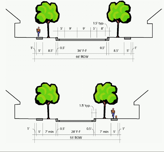
(3) Motor vehicle circulation. Motor vehicle circulation shall be designed to efficiently move motor vehicle traffic via multiple routes and to minimize conflicts with pedestrians and bicycles. Traffic calming features such as curb extensions, traffic circles, medians, and on-street parking are encouraged to slow traffic speeds. Arterial streets should generally not bisect a TND. Collector streets within the TND are intended to carry traffic from minor streets to arterial streets, include the principal entrance street to a residential development component, and may be subject to access controls. Minor streets are intended to be used primarily for access to abutting properties, and are usually not subject to access controls. Alleys are special public ways affording secondary access to the rear of abutting properties. Minimum street design standards for a TND shall be in accordance with Table 154.302.2, Figures 154.302.1 and 154.302.2.
(4) Street layout. The TND shall maintain the existing street grid, where present, and restore any disrupted street grid where feasible. The orientation of streets shall enhance the visual impact of common open spaces and prominent buildings, create lots that facilitate passive solar design, minimize street gradients, and minimize the use of double frontage lots. All streets shall extend through the development or terminate at other streets, except minor streets may temporarily "dead end" when such streets will connect to future phases or other sites outside the TND and may permanently terminate in a cul-de-sac only where necessary due to topography and where there will be a through connection via a pedestrian way or bicycle path at the end.
(5) Parking and loading requirements. All TNDs shall meet the parking and loading requirements found in §§ 154.601 through 154.605, except that the city may allow adjacent on-street parking within a TND to apply toward the minimum parking requirements. For multi-family buildings and in the required mixed-use area, shared use parking lots are encouraged, off-street parking lots may not be adjacent to or opposite from a street intersection, and parking lots shall be located to the rear or sides of buildings. The edges of parking lots, "islands," and all other areas not used for parking or vehicular circulation shall be landscaped and curbed, particularly where the parking lot is located to the side of a building. Parking lots containing more than 30 spaces shall be broken up into smaller pods with not more than 30 spaces each, with the pods separated from another by landscaped areas or buildings. Site plans shall provide a direct route to service or loading dock areas, while minimizing the movement of loading vehicles through parking areas. Reduction of impervious surfaces through the use of pervious pavement and interlocking pavers is encouraged, particularly for remote parking lots and parking areas for periodic uses.
TYPE OF STREET | STREET WIDTH, CURB-FACE TO CURB-FACE (FEET) | CURB AND GUTTER | STREET TERRACE | SIDEWALKS | BICYCLE LANES |
TYPE OF STREET | STREET WIDTH, CURB-FACE TO CURB-FACE (FEET) | CURB AND GUTTER | STREET TERRACE | SIDEWALKS | BICYCLE LANES |
Collector Street | 36 (2-sided parking) | Both sides, 1.5 feet wide | Both sides, min. 8.5 feet wide | Both sides, min. 5 feet wide - 1 foot from lot line | Where required, add 5-foot wide lanes (Can be measured to face of curb) |
30 (1-sided parking) | |||||
24 (no parking) | |||||
Minor Street | 28 (2-sided parking) | Both sides, 1.5 feet wide | Both sides, min. 7 feet wide | Both sides, min. 5 feet wide - 1 foot from lot line | None |
24 (1-sided parking) | |||||
20 (no parking) | |||||
Alley | 12 (no parking) | 1.5 foot flat ribbon | None | None | None |
(E) Other site and neighborhood design requirements.
(1) Stormwater management. Stormwater within the TND shall be managed within the TND according to the following principles and requirements:
(a) Comply with all state regulations associated with stormwater management, including the Illinois Administrative Code, and any city stormwater management ordinance;
(b) Comply with regional stormwater management plans adopted by the city;
(c) Minimize off-site stormwater runoff;
(d) Promote on-site filtration;
(e) Utilize natural stormwater management systems wherever practical;
(f) Utilize stormwater management Best Management Practices, as articulated in the Illinois Administrative Code and other professional publications;
(g) Minimize the discharge of pollutants to ground and surface water; and
(h) Maintain and protect natural topography and existing land cover to the extent reasonably practicable.
(2) Exterior lighting and utilities. The styles of proposed street and private lot lighting shall be compatible with one another. All exterior lighting within the TND shall meet the technical lighting requirements of the Illuminating Engineering Society of North America, or any city lighting ordinance if more restrictive. Street lighting shall be provided on both sides of all streets at intervals of no greater than 75 feet. More, smaller street lights as opposed to fewer, higher intensity lights, should be used. All new public and private utility installations shall be underground.
(3) On-site landscaping and screening. Overall composition and location of landscaping shall complement the scale of the development and its surroundings. In general, larger, well-placed contiguous planting areas shall be preferred to smaller, disconnected areas. Plants native to the region are encouraged. More specific landscape standards that shall be met are included in §§ 154.601 through 154.605.
(4) Street trees. An average minimum of one deciduous tree per 50 feet of public street frontage shall be required. Street tree placements may be clustered or adjusted to achieve a particular design objective or account for traffic visibility, curb openings, street lighting, and other obstructions. Street trees shall generally be located between the sidewalk and the curb and within the landscaped area of a boulevard. If placement of street trees within the right-of-way will interfere with pre-existing utility lines, trees may be planted within the private street yard adjacent to the sidewalk.
(F) Architectural and signage requirements. A variety of architectural features and building materials is encouraged to give each building or group of buildings a distinct character, while maintaining a compatible design theme throughout the TND. More specific design standards that shall be met are as follows:
(1) Existing structures. Existing structures, if determined to be historic, architecturally, or culturally significant, shall be protected from demolition or encroachment by incompatible structures or land development, to the extent reasonably practical and as controlled by the city's historic preservation program.
(2) New structures.
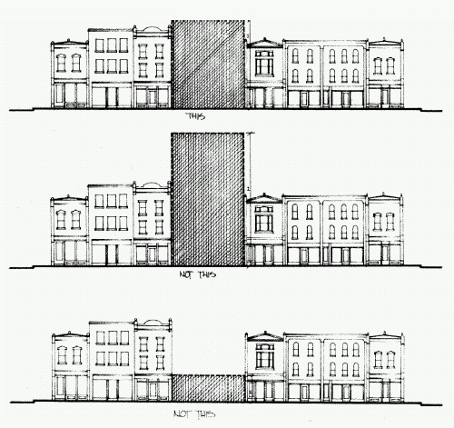
(a) Height. New structures within a TND shall be no more than one and one-half stories for single-family detached dwellings and attached dwellings, and four stories for commercial, multi-family, or mixed-use buildings. Buildings within the mixed use area shall additionally meet the standards depicted in Figure 154.302.3.
(b) Entries and facades. Similar architectural features, materials, and the articulation of a building facade shall be continued on all sides visible from a public street. The front facade of the principal building shall face onto the street yard of a public street, and not directly toward a parking lot. As buildings are moved closer to the street and to each other, special attention should be paid to design details and landscaping. Compatible building designs shall be followed for new structures on opposite sides of the same street. Porches, roof overhangs, hooded front doors or other similar architectural elements shall define the front entrance to all residences. For nonresidential buildings, a minimum of 50% of the public street facade(s) on the ground floor shall be transparent, consisting of window or door openings.
(b) Garages. Garages accessed from the public street, where garage doors face a public street, shall occupy no more than 50% of the front facade of the house. Residential garages shall either be set back a minimum of four feet to the rear of the main front facade of the dwelling structure (not including porches or other projections) or utilize side-entry layout and set back two feet from the front facade to ensure that the garage does not dominate the view from the street. These standards are illustrated in Figure 154.302.4. Varied garage setbacks along alleysare encouraged to create a more interesting streetscape and avoid cramped, monotonous, and claustrophobic alleys.
(3) Signage. Business signs, entrance monuments, and other major signs within a TND shall share a common or compatible style, which may be demonstrated by similarities in sizes, shapes, and/or materials. In addition, all signage shall meet the technical requirements of §§ 154.801 through 154.815, except that the maximum height of a freestanding sign shall be eight feet and the maximum area of a freestanding sign shall be 50 square feet.
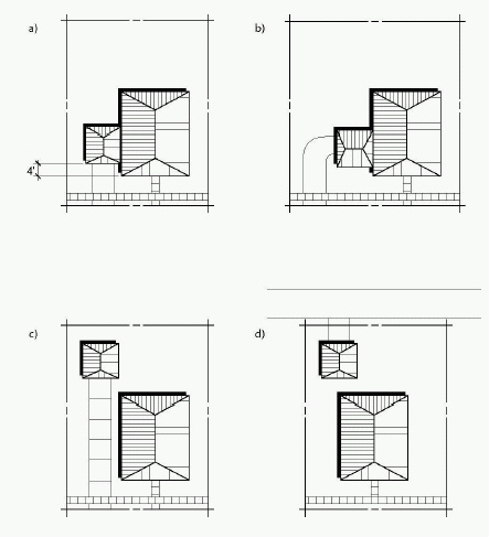
Plan-view diagrams of four alternative garage locations on a residential lot that meet design standards:
a) Attached garage is accessed from a street (street-loaded)- 4’ min setback required.
b) Attached garage is accessed from a street (side-loaded)- 2’ min setback required.
c) Detached garage, behind the house, is accessed from a street
d) Detached garage is accessed from an alley
(G) Modifications and changes. The GDP or PIP approval may include any aspect of project flexibility requested by the applicant, including but not limited to options for different uses and densities within the TND. Any subsequent change of use of any parcel of land or addition or modification of any approved development plan beyond such approved flexible aspects shall be submitted to the Zoning Board of Appeals for approval. Minor changes that do not affect the intent of the GDP or PIP may be granted by the Zoning Board of Appeals. Major changes that involve changes to the general intent of the project as expressed in the approved GDP shall be made by the City Council, following the same process as required for the original GDP approval.
(H) TND stages. Traditional neighborhood developments may be approved in the following stages:
(1) Outline development plan. An outline development plan (ODP) is an optional but encouraged first step prior to an application for a preliminary development plan for a parcel of at least 20 acres. The purpose of an ODP is to demonstrate conformance with the TND development standards, compatibility of land use and coordination of improvements within and among individually platted parcels, sections or phases of a development prior to the approval of a preliminary plan. At ODP, the proposed intensity and density of development for the entire property or for each pod designated for development on the plan is established. This step is recommended for larger, more diverse projects that are expected to be developed over a long period of time. Through this process, the general pattern of development is established with a range of densities and intensities assigned to individual pods that will be the subject of future, more detailed planning.
(a) Controlling document. All subsequent preliminary and final plans and all future development on the property shall be consistent with the approved ODP.
(b) Required information. Detailed application requirements for ODP approval are provided in § 154.923. At a minimum, plans and information submitted at this stage shall include:
1. A conceptual ("bubble") plan drawing of the general land use layout and the general location of major public streets and/or private drives.
2. A general written description of the proposed TND including:
a. General project themes and images;
b. The general mix of dwelling unit types and/or land uses;
c. Approximate residential densities and nonresidential intensities as described by dwelling units per acre, floor area ratio, maximum building size and impervious surface area ratio;
d. The general treatment of natural features;
e. The general relationship to nearby properties and public streets;
f. The general relationship of the project to the adopted Comprehensive Plan;
g. An initial draft of density and intensity, bulk, landscaping, and parking and loading standards for the development.
h. A development phasing schedule.
(2) General development plan (GDP). A general development plan (GDP) application shall be submitted to and approved by the City Council following a recommendation by the Zoning Board of Appeals. The GDP application shall include the following:
(a) Controlling document. All subsequent preliminary and final plans and all future development on the property shall be consistent with the approved GDP.
(b) Required information. Detailed application requirements for GDP approval are provided in § 154.923. At a minimum plans and information submitted at this stage shall include:
1. A location map of the subject property and its vicinity, using the city's proposed land use map from the adopted Comprehensive Plan as a base;
2. A site inventory and analysis map with topography at two foot contours to identify site assets, resources, and constraints, including, but not limited to, floodplains, wetlands, soils with limitations for building development, utility easements, slopes greater than 12%, and existing trees over eight inches in diameter or the edges of woodlands in which a majority of trees meet this criteria;
3. A conceptual site plan or neighborhood development plan, at a scale of not less than one inch equals 100 feet, which indicates existing and proposed major public streets, private drives, and paths; different land use areas by proposed type and density; and proposed recreational, open space, and generalized stormwater management areas and facilities;
4. An analysis or map showing the general locations of proposed public utility connections, and anticipated upgrades to public utilities to serve the planned development;
5. A conceptual landscape plan showing general locations and types of proposed landscaping, including maintenance of existing vegetation where appropriate;
6. A phasing plan, where applicable;
7. A conceptual stormwater management plan identifying the proposed patterns of major stormwater run-off, locations of stormwater infiltration areas, and other significant stormwater management features, including relationships to and alignment with any regional stormwater management plan adopted by the city;
8. Typical proposed building elevations identifying the architectural style of each of the different use areas, along with a general program for proposed signage;
9. A written report that provides general information about the site conditions; project themes and images; development objectives; mix of uses and dwelling unit types; approximate residential densities and nonresidential development intensities; and the relationship of the project to adjacent land uses, the city's adopted Comprehensive Plan and other applicable adopted city plans, and the purpose and criteria for TNDs included in this section.
(3) Precise implementation plan (PIP). The PIP application shall include the following, along with information required under § 154.914 for site plan review.
(a) Required information.
1. A location map of the PIP area and the GDP area (if different) and its vicinity, using the city's proposed land use map from the adopted Comprehensive Plan as a base;
2. Where a land division or lot consolidation is proposed, a preliminary plat or CSM of the entire development area included in the PIP, meeting all applicable requirements of Chapter 153, Subdivision Regulations.
3. A detailed neighborhood development plan showing the precise arrangement, design, and uses of different lots, buildings, driveways, parking areas, parks and open spaces, and paths;
4. Typical elevations or detailed design standards for single- and two-family residential buildings and detailed elevations of all proposed nonresidential, mixed use, and multi-family residential buildings. Such detailed elevations shall identify all signs; the percentage of ground floor commercial facade in windows; and the location, height and materials for screening walls and fences including those proposed to surround outdoor trash and recyclable storage areas, utility meters, and ground and rooftop mechanical equipment;
5. Detailed signage plans demonstrating a unified or compatible sign design theme for major signage in the TND;
6. A detailed storm water management and erosion control plan, meeting all state and city requirements and consistent and assisting with the implementation of regional stormwater management plans adopted by the city;
7. Arrangements, bylaws, provisions or covenants which govern the organizational structure, use, architectural standards, maintenance, and continued protection of the TND.
8. A written report describing the proposed PIP, including specific project themes and images, a specific mix of dwelling unit types and/or land uses, specific densities and dimensional standards for residential and non-residential uses, the specific treatment of open space areas, and an evaluation of the consistency of the proposed PIP with the previously approved GDP.
(Ord. O-05-04, passed 4-11-05)