Loading...
(A) Commercial wireless communication towers may be considered either a principal or accessory use, as a special land use only on public property. This includes mounting onto a publicly or privately owned tower or publicly elevated storage tank or tower. All commercial wireless communication towers enacted after this chapter must provide collocation.
(B) Commercial wireless communication towers are only allowed on municipal property and require a municipal franchise agreement. Tower lease areas shall be maintained in a neat and orderly manner and shall be completely fenced. Effective landscaping and screening shall be used around fenced areas. Wireless communication equipment shall be stored inside secured shelters and shall use natural materials and neutral colors for the exterior. Leased areas shall be appropriately lit.
(C) A privately owned, non-commercial tower may be erected as an accessory use in any district, provided such tower does not exceed 60 feet in height, and is owned and operated by a federally-licensed amateur radio station operator or is used exclusively for receive only antennas. These towers shall not have support wires extending out horizontally from the tower more than ten feet in any direction and shall be safely maintained. Support wires and towers may not be erected or placed closer than ten feet to any side or rear lot line. Support wires and towers are prohibited from being located in the front yard. Towers must be erected, mounted and maintained in a safe manner.
ZONING DISTRICTS AND BOUNDARIES
For the purposes of this chapter, the Village of Fowler is hereby divided into the following zone districts:
Zoning Ordinance Sections | Zoning District Name | District Symbol |
Zoning Ordinance Sections | Zoning District Name | District Symbol |
Single-Family Residential | R-1 | |
Single, Two & Multiple Family Residential | R-2 | |
Central Business District | C-1 | |
General Commercial | C-2 | |
Industrial | I | |
Planned Unit Development | PUD | |
(A) Boundaries. The boundaries of the districts identified in this subchapter are hereby established as shown on a map entitled "The Zoning Map of the Village of Fowler, Michigan" which accompanies this chapter and is made a part of this chapter. Except where referenced on said map to a street line, water body, or other designated line by dimensions shown on said map, the district boundary lines follow lot lines or the center lines of streets or alleys or railroad rights-of-way as they existed at the time of adoption of this chapter.
(B) Boundary interpretation. Matters of interpretation concerning the exact location of district boundary lines shall be determined by the Zoning Administrator.
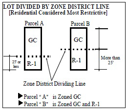
Where a district boundary line, as established in this chapter or as shown on the Zoning Map, divides a lot or lots in common ownership and of record at the time of enactment of this chapter the least restrictive use shall be considered as extending to the entire lot, if the more restrictive portion of such lot is entirely within 25 feet or less of said dividing district boundary line. The use so extended shall be deemed to be conforming. If the more restrictive portion of the lot is not entirely within 25 feet of said dividing district boundary line, the various portions of the lot shall be zoned according to the underlying zone district classifications.
Whenever any area is annexed into the Village of Fowler, one of the following rules shall apply:
(A) Land zoned previous to annexation shall be a district of the class to which it most nearly conforms under this chapter. The Planning Commission shall recommend the classification to the Village Council, who shall determine by resolution the zoning classification into which the property will be placed.
(B) Land not zoned prior to annexation shall be automatically classified as a PUD in a district of the class to which it most nearly conforms under the chapter. This shall be determined by the Planning Commission and shall remain in effect until a zoning map for the area has been adopted by the Village Council. The Planning Commission shall recommend appropriate zoning districts for such area within three months after Village Council has referred the matter to the Commission.
Whenever all or part of a street, alley or other public way is vacated, it shall automatically become a part of the district to which it attaches. If a vacated area is bordered by two different districts, the area is divided along a line half way between them according to the adjacent zone, unless the Village Council shall otherwise designate.
R-1 SINGLE FAMILY RESIDENTIAL DISTRICT
This district is intended to provide a low-density, single family residential living environment and to foster stable, high quality neighborhoods. At the same time the regulations for this district recognize the need to preserve existing housing stock, allow the full development of older subdivisions, and provide new quality housing. Certain non-residential uses are allowed to further the stability of residential neighborhoods.
Land and/or buildings in the R-1 District may be used for the following purposes by right:
(A) Single-family detached dwellings.
(B) Day care, family homes.
(C) State licensed residential family care facilities.
(E) Public parks.
(F) Farms.
(G) Accessory buildings, structures, and uses (to the permitted and special land uses).
Land and/or buildings in the R-1 District may be used for the following purposes when approved by the Planning Commission in accordance with the requirements of the Special Land Use subchapter:
(A) Utility and public service buildings, without storage yards, but not including essential public services such as poles, wires, and underground utility systems.
(B) Private, non-commercial or institutional recreation parks and recreation centers.
(C) Golf courses.
(D) Schools.
(E) Bed and breakfast inns.
(F) Hospitals, including associated offices and related uses, such as pharmacies, clinics, and other similar uses integral to such use.
(G) Nursing, or convalescent homes.
(H) Churches, synagogues, temples, and other religious places of worship.
(I) Lodges, and private clubs.
(J) Governmental buildings and libraries.
(K) State licensed residential group facilities.
(L) Cemeteries.
Loading...