Loading...
For the purposes of this chapter, the Village of Fowler is hereby divided into the following zone districts:
Zoning Ordinance Sections | Zoning District Name | District Symbol |
Zoning Ordinance Sections | Zoning District Name | District Symbol |
Single-Family Residential | R-1 | |
Single, Two & Multiple Family Residential | R-2 | |
Central Business District | C-1 | |
General Commercial | C-2 | |
Industrial | I | |
Planned Unit Development | PUD | |
(A) Boundaries. The boundaries of the districts identified in this subchapter are hereby established as shown on a map entitled "The Zoning Map of the Village of Fowler, Michigan" which accompanies this chapter and is made a part of this chapter. Except where referenced on said map to a street line, water body, or other designated line by dimensions shown on said map, the district boundary lines follow lot lines or the center lines of streets or alleys or railroad rights-of-way as they existed at the time of adoption of this chapter.
(B) Boundary interpretation. Matters of interpretation concerning the exact location of district boundary lines shall be determined by the Zoning Administrator.
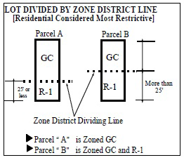
Where a district boundary line, as established in this chapter or as shown on the Zoning Map, divides a lot or lots in common ownership and of record at the time of enactment of this chapter the least restrictive use shall be considered as extending to the entire lot, if the more restrictive portion of such lot is entirely within 25 feet or less of said dividing district boundary line. The use so extended shall be deemed to be conforming. If the more restrictive portion of the lot is not entirely within 25 feet of said dividing district boundary line, the various portions of the lot shall be zoned according to the underlying zone district classifications.
Whenever any area is annexed into the Village of Fowler, one of the following rules shall apply:
(A) Land zoned previous to annexation shall be a district of the class to which it most nearly conforms under this chapter. The Planning Commission shall recommend the classification to the Village Council, who shall determine by resolution the zoning classification into which the property will be placed.
(B) Land not zoned prior to annexation shall be automatically classified as a PUD in a district of the class to which it most nearly conforms under the chapter. This shall be determined by the Planning Commission and shall remain in effect until a zoning map for the area has been adopted by the Village Council. The Planning Commission shall recommend appropriate zoning districts for such area within three months after Village Council has referred the matter to the Commission.
Whenever all or part of a street, alley or other public way is vacated, it shall automatically become a part of the district to which it attaches. If a vacated area is bordered by two different districts, the area is divided along a line half way between them according to the adjacent zone, unless the Village Council shall otherwise designate.
R-1 SINGLE FAMILY RESIDENTIAL DISTRICT
Loading...