Loading...
A. Purpose: The purpose of this Section is to ensure that Wireless Communication Facilities that are installed within the City comply with the standards of this UDC, including the use-specific standards in Subsection 7.3.303H.1 (Wireless Communication Facility).
B. Applicability: The WCF Permit procedure applies to all WCFs that are subject to the standards of Subsection 7.3.303H.1 (Wireless Communication Facility).
C. WCF Permit Process:
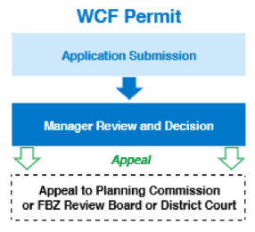
1. Application Submission
a. In addition to the appropriate application form identified in Table 7.5.5-A, the applicant shall submit with the application:
(1) A Signal Non-Interference Letter;
(2) A Radio Frequency Emissions Letter;
(3) A lease, license, or other written permission from the owner of the site;
(4) A scaled site plan, photo simulations (before and after), scaled elevation view, and line-of-sight drawing/rendering;
(5) If the application is for a new WCF, a Collocation Letter;
(6) Other supporting drawings, calculations, and other documentation, signed and sealed by appropriate qualified professionals, showing the location and dimension of all improvements, including information concerning topography, radio frequency coverage, tower height, setbacks, drives, parking, fencing, landscaping, adjacent uses, drainage, and other information deemed by the Manager to be necessary to assess compliance with this Section; and
(7) Except for Small Cell Facilities in the right-of-way, prior to approval, affidavits shall be required from the owner of the property and from the applicant acknowledging that each is responsible for the removal of a WCF that is abandoned or is unused for a period of twelve (12) months.
b. For the first WCF application submitted to the City in a calendar year, the applicant shall provide to the Manager a narrative and map description of the applicant's existing or then-currently proposed WCFs within the City. If possible, this will include a before-and-after graphic or map showing coverage changes by the installation of the WCF. This provision is not intended to be a requirement that the applicant submit its business plan or proprietary information, or make commitments regarding locations of WCFs within the City. It is intended to allow all applicants for WCFs to share general information, assist in the City's comprehensive planning process, and promote Collocation by identifying areas in which WCFs might be appropriately constructed for multiple users. The requirement of any inventory of existing sites may be satisfied for Small Cell Facility applications through a master license agreement or similar authorization executed with the City.
c. The Manager may share such information with other applicants applying for administrative approvals or conditional permits under this Section or other organizations seeking to locate WCFs within the jurisdiction of the City, provided however, that the Department is not, by sharing such information, in any way representing or warranting that such sites are available or suitable.
WCF Application Forms | |
Facility Type [1] | Application |
Residential Zone Districts | |
Nonstealth freestanding facility [2] | CM1 [3] |
Roof/wall mount: [4] | |
10 feet or less above roofline [5] | CM3 [6] |
More than 10 feet above roofline and less than the maximum height of zoning district | CM2 [7] |
Located on single- and two-family dwelling units | CM1 [3] |
Stealth freestanding facility [2] | CM2 [7] |
Mixed-Use and Nonresidential Zone Districts | |
Broadcasting tower | CM1 [3] |
Collocation on existing facility [8] | CM3 [6] |
Nonstealth freestanding facility [9] | CM1 [3] |
Roof/wall mount: | |
10 feet or less above roofline [5] | CM3 [6] |
More than 10 feet above roofline | CM2 [7] |
Stealth freestanding facility: [2] | |
Equal to or less than maximum height of zone district | CM2 [7] |
Located within utility substations or within utility easements and exceeding the height of other vertical infrastructure by more than 4 feet | CM1 [3] |
Small Cell Facilities in the right-of-way | CM5 [10] |
NOTES [1] Eligible Facilities Requests application requirements are addressed in Section 3 (WCF Eligible Facilities Requests). [2] Within residential zones, applications for freestanding facilities (stealth and nonstealth) shall only be considered on multi-family, institutional, or nonresidential sites such as churches, schools, museums, etc. Except for Small Cell Facilities, freestanding facilities are not permitted in conjunction with a single- or two-family building. [3] Conditional use (CM1) applications shall be subject to Planning Commission review as a conditional use in accordance with Section 7.5.601 (Conditional Use). [4] Except with respect to Small Cell Facilities, roof/wall mount on single- and two-family buildings shall only be permitted as a conditional use where the design, materials, color, and location of the facilities blend in architecturally with the wall and substantially conceals the antennas and equipment. [5] The 10-foot extension above the building is allowed to exceed the maximum height limitation of the zone district if screened by existing screens or parapets as provided for in the design standards. [6] WCF Development Plan (CM3) applications shall be subject to expedited administrative review in accord with the procedures in Section 7.5.515 (Development Plan). No public notice or site posting shall be required unless determined to be necessary by the Manager. [7] WCF Development Plan (CM2) applications shall be subject to administrative review in accord with the procedures in Section 7.5.515 (Development Plan). The findings of this Section and notice shall be provided as required by this UDC. [8] Except for Eligible Facilities Requests, the collocation height shall be restricted to the maximum height of the zone district. If the height exceeds the maximum height of the zone district, an Administrative Waiver in accord with Subsection 7.3.303H.1.f(10) (Administrative Waiver) shall be required. [9] In the APD and PF zone districts, a nonstealth freestanding facility requires a CM2 Development Plan application. [10] Small Cell Facilities in the right-of-way (CM5) applications shall be subject to administrative review in accordance with the procedures and findings of this article. No public notice or site posting shall be required unless determined to be necessary by the Manager. | |
2. Determination of Application Completeness:
a. Review Periods:
(1) Subject to tolling as provided in Subsection b below, and unless a longer review period is agreed to by the applicant, applications for WCF shall be subject to the following review period:
(a) For a new WCF other than a Small Cell Facility in the right-of-way, one hundred and fifty (150) days.
(b) For a Small Cell Facility in the right-of-way, ninety (90) days.
(c) For modifications to, or collocations with, existing WCFs that do not qualify as an Eligible Facilities Request, ninety (90) days.
(2) The City's failure to meet the review period shall not be deemed approval of the application.
b. Tolling of Review Period:
(1) The review period begins to run when the application is filed and may be tolled where the City determines that the application is incomplete, or by mutual agreement of the City and the applicant.
(2) To toll the review period for incompleteness, the City must provide written notice to the applicant within thirty (30) days of receipt of the application.
(3) The timeframe for review period continues running again when the applicant makes a supplemental written submission in response to the City's notice of incompleteness.
3. Manager's Decision: The Manager shall review the WCF Permit application and shall approve, approve with conditions, or deny the petition in accord with Subsection 7.5.407D.1 (Manager), the provisions of this Section 7.5.513, the use-specific standards in Subsection 7.3.303H.1 (Wireless Communication Facility), and the review criteria in Section 7.5.409 (General Criteria for Approval). Each decision shall be in writing and supported by substantial evidence in a written record. The applicant shall receive a copy of the decision.
4. Post-Decision Actions or Limitations: The following provisions apply following the Manager's decision to approve or approve with conditions an application:
a. The Manager's decision regarding a WCF Permit for a small cell facility may not be appealed pursuant to Section 7.5.415 (Appeals).
b. An approved application for a Small Cell Facility in the right-of-way shall expire after one (1) year if construction of the Small Cell Facility has not been substantially completed.
c. Upon approval, all installation or modifications done to WCFs must be completed in accordance with all applicable building, structural, electrical, and safety requirements as set forth in the City Code and any other applicable laws or regulations.
d. All WCFs shall:
(1) Comply with any permit or license issued by a local, state, or federal agency with jurisdiction over the WCF;
(2) Comply with existing entitlements for the underlying real property;
(3) Be maintained in good working condition and to the standards established at the time of application approval; and
(4) Remain free from trash, debris, litter, graffiti, and other forms of vandalism. Any damage shall be repaired as soon as practicable, and in no instance more than thirty (30) days from the time of notification by the City or after discovery by the owner or operator of the site. Notwithstanding the foregoing, any graffiti on WCFs located in the rights-of-way or on other City-owned property may be removed by the City at its discretion and without liability to the City upon fourteen (14) days' notice to the owner/and or operator of the WCF. The owner and/or operator of the WCF shall pay all costs of such removal within thirty (30) days after receipt of an invoice from the City.
e. Upon request by the City, the applicant shall provide a compliance report within forty-five (45) days after installation of a WCF, demonstrating that as installed and in operation, the WCF complies with all conditions of approval, applicable Code requirements, and standard regulations. (Ord. 23-03)
LAND USE PLANS AND DEVELOPMENT PLANS
A. Purpose: A Land Use Plan is used to review the impact of the proposed land uses on surrounding development early in the project planning process. Land Use Plans contain an outline of a proposed zone district or project that shows land uses, development intensities and densities, access points, green space or public open space systems, and areas that should be preserved or protected.
B. Applicability:
1. General: A Land Use Plan is required in connection with the following types of applications and shall be approved before or simultaneously with the following types of applications:
a. An application to annex land into the City.
b. An application to establish or change the boundaries of any zone district, unless specifically waived pursuant to Subsection 3 below..
2. Expiration and Modification of Previously Approved Plans: A Master Plan or Concept Plan approved prior to the Effective Date shall not expire unless the Master or Concept Plan includes an expiration date. Modifications to adopted Master Plans or Concept Plans may be processed pursuant to Section 7.5.516 (Modification of Approved Applications).
3. Waiver by Manager and Land Use Statement:
a. The Manager may waive the requirement for approval of a Land Use Plan if the Manager determines that requiring approval of a Land Use Plan would not serve the purposes of this Section or the UDC because:
(1) The land area under review is less than ten (10) acres and is planned to be developed in a single phase;
(2) The land is contained in and subject to a previously approved Master or Concept Plan;
(3) The land is included in a Development Plan application;
(4) The land area is part of an established surrounding development pattern;
(5) The proposed zoning pattern for the land aligns with adjacent existing zoning or development; and/or
(6) Major infrastructure or urban services for the land including but not limited to access points and roadway systems, have already been established and are not proposed to be changed.
b. An applicant requesting a Land Use Plan waiver shall submit a Land Use Statement demonstrating that the application complies with the criteria for a waiver outlined in Subsection a above. The Manager's decision on the Land Use Statement shall be in writing and may not be appealed.
C. Land Use Plan Approval Process:

1. Application Submission:
a. General Requirements: In addition to the application submission requirements in Section 7.5.403 (Application Submission), the following items shall be included in an application submission unless the Manager determines that the required information is not necessary due to the scope of the Land Use Plan.
(1) Project Statement: The proposed application shall include a statement identifying and demonstrating:
(a) The development's proposed land uses, housing densities (if applicable), and development intensity; and
(b) Evaluation of how the Plan meets Land Use Plan review criteria.
(2) Access Nodes: The proposed Land Use Plan must indicate points of access, ingress, and egress.
(3) Roadway System: The proposed Land Use Plan must indicate internal connections from proposed access nodes.
(4) R-Flex and PDZ Districts: For development that is proposed in an R-Flex district or a PDZ district, the proposed Land Use Plan shall indicate:
(a) The proposed overall housing density and the locations of different housing types; and
(b) The location of green space, recreational facilities, or other common amenities as applicable.
(5) Use Types: For development that is proposed in an MX district or a PDZ district, the proposed Land Use Plan shall indicate the location of use types permitted within the proposed development.
(7) Fiscal Analysis for Proposed Land Use Plan: A Land Use Plan that accompanies a request for annexation shall include the following information and demonstrate compliance with the following standards:
(a) A fiscal impact analysis and a calculation of total costs to the City to provide infrastructure to the proposed development for a period of at least ten (10) years;
(9) Geohazard Hazard Study: The proposed Land Use Plan shall include a Geologic Hazard Study if required in accord with Part 7.4.5 (Geological Hazards).
(10) Phasing Plan: If the applicant wishes to phase development within a Land Use Plan area, the application shall include a phasing plan reflecting the established maximum residential density or mixed-use or nonresidential development intensity within the applicable zone district.
b. Zone Specific Requirements: Additional requirements and criteria for the Land Use Plan may be contained in the description of the base zone district where the property is located (see Article 7.2 (Zone Districts)) or in an overlay district that applies to the property (see Part 7.2.6 (Overlay Districts)).
2. Decision-Making Body:
a. Except as noted in Subsection b below, all Land Use Plans shall be reviewed and decided by the Manager based on the criteria in Subsection 3 below.
b. Land Use Plans submitted in connection with an application to establish a zone district or to change zone district boundaries shall be reviewed by the Planning Commission and City Council and a decision made by City Council pursuant to Section 7.5.704 (Zoning Map Amendment (Rezoning)).
3. Land Use Plan Criteria: If the Land Use Plan is submitted in connection with an application to establish a zone district or to change zone district boundaries shall be reviewed based on the following criteria:
a. Consistency with the Colorado Springs Comprehensive Plan and other plans and policies adopted by City Council;
b. Consistency with development standards the zone district in which the property is located, or would be located after a requested zone district change;
c. Compatibility with the land uses and development intensities surrounding the property;
d. Impacts of the permitted or requested uses, appropriate to the type of development, the neighborhood, and the community;
e. Adequacy of proposed ingress/egress points and traffic circulation, both on and off the site;
f. Capacity of the existing streets, utilities, parks, schools, and other public facilities to serve the proposed development;
g. Promotion of transitions in height, intensity, or character between proposed non-residential or mixed-use development and nearby low-density residential zone districts.
4. Conditions and Modifications:
a. If a Land Use Plan is approved or approved with conditions, all subsequent development approvals and permits within the Land Use Plan area shall be consistent with the Land Use Plan as approved, subject to Subsection c below.
b. A proposal to modify an approved Land Use Plan shall be reviewed and a decision made pursuant to Section 7.5.516 (Modification of Approved Applications).
c. An approved modification of a Development Plan pursuant to Section 7.5.516 (Modification of Approved Applications) shall be treated as a modification of a Land Use Plan affecting the same property, and no revision or resubmission of the Land Use Plan shall be required, provided that the modified Development Plan includes a clear statement that it serves as a modification of the affected Land Use Plan as of the date on which the modification was approved. (Ord. 23-03)
A. Purpose: The Purpose of this Section is to allow for review of a plan for development to evaluate the specific impacts of the proposed land use and site design on the adjacent properties, neighborhood, schools, parks, road systems, and existing and planned infrastructure to ensure that proposed development is appropriate at a particular location. The specific purposes of the Development Plan review procedure are to:
1. Ensure the development complies with the standards of this UDC, including site development standards;
2. Minimize potential adverse effects of proposed land use by proposing specific site design solutions;
3. Ensure points of access, internal circulation, and pedestrian movement to all proposed lots, land uses, and adjacent properties;
4. Ensure, when used in conjunction with a final Subdivision Plat, that all subdivision requirements include easement and public facility dedication requirements can be met;
5. Establish the approval of specified uses, dimensional standards, site design, and other conditions; and
6. Evaluate existing and proposed road systems, utilities, schools, parks, and other public facilities to determine if they are adequate to serve the proposed project.
B. Applicability:
1. A Development Plan is required in connection with the following types of applications, and shall be approved before or simultaneously with related applications, unless specifically exempted in Subsection 2 below.
a. All new construction.
b. When no Development Plan for the property has previously been approved by the City, additions to an existing building that cumulatively, as of September 12, 1995, increases the gross floor area of the building by fifty (50) percent or greater.
c. When required by the Planning Commission or City Council, as a condition of record for the establishing or changing the boundaries of a zone district.
d. Conversion of vacant land into a new use.
e. Application for a Conditional Use Permit.
f. The conversion of an existing use to a use in another category as set forth in Part 7.3.2.
g. The total redevelopment (demolition and new construction) of an existing building or site.
2. Notwithstanding Subsection 1 above, a Development Plan is not required in connection with the following:
a. New construction of or an addition to an existing detached single-family or attached two-family residential structure, accessory dwelling unit, and accessory structures upon an existing platted lot.
b. Additions to an existing building that cumulatively, after September 12, 1995, increase the gross floor area of the building by less than fifty (50) percent.
c. Public parks in which a Park Master Plan has been or will be reviewed by the Parks, Recreation, and Cultural Services Department.
d. A project of the federal government if both the property and the structure will be owned, maintained, and operated by the government.
e. One (1) lot single-family residentially zoned property located within the HS-O district platted prior to June 7, 1996, and not part of an existing Development Plan. However, prior to issuance of Building Permits for homes on these properties, an approved Hillside Site and Grading Plan and geologic hazard study are required.
f. If the Manager finds that the scope or potential impacts of the project does not warrant the review and approval of a Development Plan.
3. A Land Use Plan shall be approved prior to the approval of a Development Plan unless a Land Use Plan is not required pursuant to this UDC.
4. A Development Plan is a planning document only. Approval of a Development Plan does not grant any variances to this UDC and does not waive any of the requirements of design as contained in the City of Colorado Springs Engineering Criteria. Development Plans shall not be considered construction drawings.
C. Development Plan Approval Process:

1. Application Submission:
a. General Requirements: A Development Plan must meet the following requirements:
(1) Access and interior roadway systems shall be reflective of the approved Land Use Plan if applicable.
(2) A phasing plan shall be required if the applicant proposes to phase the submittal of a Development Plan for the zone district or phase the platting and construction of the development. The phasing plan shall propose a sequence of development and the provision of required public improvements. Each phase of a plan shall reflect the established zone density of the overall Land Use Plan.
(3) An application that proposes the removal of residential dwellings with rents below the fair market rate established by the U.S. Department of Housing and Urban Development shall be forwarded to the Manager for review and comment.
b. Zone Specific Requirements: Additional requirements and criteria for the Development Plan may be contained in the description of the base zone district where the property is located (see Article 7.2 (Zone Districts)) or in an overlay district that applies to the property (see Part 7.2.6 (Overlay Districts)).
c. Preliminary Development Plan Review:
(1) A preliminary Development Plan review is required in connection with the following types of applications and shall be approved before or simultaneously with related applications.
(a) For properties located within an A, R-E, R-1 9, R-1 6, or R-2 zone districts when, prior to the issuance of a Building Permit, an approved Final Plat, intended for single-family or two-family residential use, has been recorded.
(b) For a single- and two-family residential use located within a single- and two-family residentially zoned property, upon an already platted lot, and where no Development Plan exists.
(2) The Manager may require that a preliminary plan include preliminary grading plan, preliminary utilities plan, and site plan.
D. Development Plan Review Criteria:
1. General: The decision-making body shall review the Development Plan application or amendment and approve, approve with conditions, or deny the application based on the following criteria:
a. The decision-making criteria in Section 7.5.409 (General Criteria for Approval) apply unless modified by this Subsection 4;
b. The application complies with all applicable Use-specific standards in Part 7.3.3 related to the proposed use(s);
c. The details of the site design, building location, orientation, and exterior building materials are compatible and harmonious with the surrounding neighborhood, buildings, and uses, including not-yet-developed uses identified in approved Development Plans;
d. Significant off-site impacts reasonably anticipated as a result of the project are mitigated or offset to the extent proportional and practicable;
e. The Development Plan substantially complies with any City-adopted plans that are applicable to the site, such as Land Use Plans, approved master plans for a specific development, neighborhood plans, corridor plans, facilities plans, urban renewal plans, or design manuals;
f. The project meets dimensional standards applicable to the zone district, or any applicable requirement in an FBZ or PDZ district;
g. The project grading, drainage, flood protection, stormwater quality, and stormwater mitigation comply with the City's Engineering Criteria, the drainage report prepared for the project on file with the Stormwater Enterprise Manager, and other federal, state, and City regulations;
h. The project complies with all the development standards of Article 7.4 (Development Standards and Incentives), including access and connectivity requirements in Part 7.4.4 (Access and Connectivity), the landscaping and green space requirements in Part 7.4.9 (Landscaping and Green Space), and the parking and loading requirements in Part 7.4.10 (Parking and Loading);
i. The project complies with all applicable requirements of any Overlay District in which the property is located, as listed in Part 7.2.6 (Overlay Districts);
j. The project preserves, protects, integrates, or mitigates impacts to any identified sensitive or hazardous natural features associated with the site;
k. The project connects to or extends adequate public utilities to the site. As required by Colorado Springs Utilities, the project will extend the utilities to connect to surrounding properties; and
l. If necessary to address increased impacts on existing roadways and intersections, the project includes roadway and intersection improvements to provide for safe and efficient movement of multi-modal traffic, pedestrians, and emergency vehicles in accordance with the Engineering Criteria, public safety needs for ingress and egress, and a City accepted traffic impact study, if required, prepared for the project.
2. Streamside Overlay Approval Criteria: In addition to the Development Plan review criteria as set forth in Subsection 1 above, all Development Plans submitted for review for property within the SS-O district shall meet all standards as required by Section 7.2.603 (SS-O: Streamside Overlay), unless any of these requirements are waived by the Manager.
3. Hillside Overlay Approval Criteria: In addition to the Development Plan review criteria as set forth in Subsection 1 above, all Development Plans submitted for review for property within the HS-O district shall include all documentation required by, and shall meet all standards in Section 7.2.610 (HS-O: Hillside Overlay), unless any of these requirements are waived by the Manager based on the size, scale, or potential impacts of the application.
4. Airport Overlay Approval Criteria: In addition to the Development Plan review criteria as set forth in Subsection 1 above, all Development Plans submitted for review for property within the AP-O or AF-O districts shall include all documentation required by, and shall meet all standards in Sections 7.2.601 (AP-O: Airport Overlay) or 7.2.602 (AF-O: United States Air Force Academy Overlay), unless any of these requirements are waived by the Manager based on the size, scale, or potential impacts of the application, and shall comply with the following criteria:
a. Development Plans within the AP-O: Airport Overlay:
(1) All Development Plans submitted together with a Final Plat in which any portion of the property is located within the AP-O district shall include the following statement:
"An avigation easement effecting the subject property and development is established by the "Subdivision Plat Name" Subdivision Plat. This easement is subject to the terms and conditions as specified in the instrument recorded under reception no. 217069667 of the records of El Paso County, Colorado."
(2) All Development Plans submitted on an existing platted lot in which any portion of the property is located within the AP-O district and that does not have an existing avigation easement across the property, shall include the following statement:
"Prior to issuance of a Building Permit or beginning any development, an avigation easement for the benefit of the Colorado Springs Airport will be established either by Subdivision Plat or separate recorded instrument."
b. Development Plans within the AF-O: United States Air Force Academy Overlay:
(1) All Development Plans submitted together with a Final Plat in which any portion of the property is located within the AF-O district shall include the following statement:
"Note: This property may be impacted by noise and other similar sensory effects of flight caused by aircraft both in the United States Air Force Academy's Airmanship program and during special events. This notice shall remain in effect until the Air Force Academy shall cease to be used for flight training purposes, or until all airports on the Air Force Academy shall cease to be actively used. This notice shall run in perpetuity with the land."
(2) All Development Plans submitted on an existing platted lot in which any portion of the property is located within the AF-O district and that does not have an existing avigation easement across the property, shall include the following statement:
"All lots and tracts within this subdivision are subject to an avigation easement to the United States Air Force Academy as recorded under reception no. _____________ in the office of the Clerk and Recorder of El Paso, County, Colorado."
E. Decision-Making Body: The decision-making body shall review the Development Plan application or amendment application and shall approve, approve with conditions, or deny the application based on applicable criteria listed in Subsection D above.
1. Manager Decisions: The Manager shall determine if the Development Plan meets the criteria in Subsection D above and approve or refer to the Planning Commission if found necessary for final review authority.
2. Recommendation to the Planning Commission:
a. If the Development Plan is referred to the Planning Commission, the Manager shall prepare a recommendation for the Planning Commission to approve, approve with conditions, or deny the Development Plan based on the criteria in Subsection D above.
b. Development Plans submitted in connection with an application for a Conditional Use Permit shall be reviewed and a decision made by the Planning Commission pursuant to Section 7.5.601 (Conditional Use).
F. Post-Decision Actions and Limitations:
1. Expiration:
a. Except as stated in Subsection b, a Development Plan expires six (6) years after approval if no Building Permit has been issued or no use illustrated on the plan has commenced. Prior to the expiration of a Development Plan, the applicant may request and the Manager may authorize a maximum of two (2), two-year extensions of the Development Plan approval if a review of the plan shows that no major changes in the City's development standards or in the development pattern of the surrounding properties has occurred.
b. A Development Plan does not expire for:
(1) A single-family residential subdivision project when a final Subdivision Plat for all or a portion of the individual lots has been recorded.
(2) A project where public water, sewer, electric, and gas utilities and public or private streets, drainage, and other public improvements have been installed, constructed, inspected, and accepted by the City.
(3) Any part of the Development Plan area that has been constructed or a use authorized by the Development Plan has commenced.
2. Reconstruction of Damaged Buildings with a Previously Approved Development Plan: A building or buildings may be rebuilt according to the approved Development Plan within six (6) years of the date of damage or destruction.
3. Continuing Validity of Land Use Plan: If a Development Plan is approved for part of an area within an approved Land Use Plan, the remaining area(s) of the Land Use Plan shall remain approved and valid unless the Manager determines that the Development Plan differs significantly from the Land Use Plan in way that could create adverse impacts on surrounding properties or could create difficulties or inefficiencies in the delivery of City services.
4. Continuing Compliance Required: All properties subject to an approved Development Plan shall be developed and maintained in accord with the approved Plan. All new construction, alteration, enlargement, or modification of existing structures and changes of land uses must substantially conform to the approved Development Plan or as amended or as modified. (Ord. 23-03)
A. Applicability: This Section applies to all applications to modify an approval granted under this UDC. Requests to deviate from the standards in this UDC prior to granting of an initial development approval or permit are reviewed pursuant to Sections 7.5.524 (Administrative Adjustment) or 7.5.525 (Development Standards Adjustment).
B. Procedure: Following City approval of an application:
1. A Minor Modification of the permit or approval may be approved by the Manager as described in this Section, unless a condition of the permit or approval requires that the type of modification being requested be heard by the Planning Commission or City Council.
2. A Major Modification to the permit or approval may only be approved by the decision-making body that approved the original permit or approval, using the same procedure used for the original permit or approval.
3. Changes to or relocation of an easement not held by the City shall require the approval of the easement holder. Relocation of a lot line approved by the City does not result in any changes to existing recorded easements defined with respect to lot lines.
C. Major and Minor Modifications: The following criteria shall be used to categorize a request to modify an approval as a Major or Minor Modification.
1. Major Modifications: Major Modifications include any modification that includes any of the following:
a. The creation of new freestanding buildings over two hundred (200) square feet in gross floor area;
b. An increase in gross floor area of the established square footage by fifteen (15) percent or more;
c. A significant relocation of buildings, lot lines, and easements for which the City is the easement holder, as determined by the Manager;
d. Relocation of points of access that do not clearly improve traffic circulation on adjacent public rights-of-way, as determined by the Traffic Engineer;
e. Any change to the applicable zoning standards including allowing a more intense land use or increase in density permitted in the zone district where the property is located, but not included in the development approval or permit;
f. Any increase of maximum building heights in the development approval or permit, except those that could have been approved by the Manager at the time of original development approval pursuant to Section 7.5.524 (Administrative Adjustment);
g. Any decrease of building setbacks, except those that could have been approved by the Manager at the time of original development approval pursuant to Section 7.5.524 (Administrative Adjustment);
h. Any decrease of required perimeter landscape, except those that could have been approved by the Manager at the time of original development approval pursuant to Section 7.4.913 (Alternatives and Adjustments); or
i. Any renewal of an expired Development Plan in which major design changes are necessary to comply with current development standards.
2. Minor Modifications: Minor Modifications are those that include anything that is not a Major Modification as defined above.
3. Consistency with Conditions on Modification: If the development approval or permit proposed to be modified includes a condition that may only be approved by Planning Commission or City Council, the modification shall be treated as a Major Modification and may only be approved by the decision-making body named in that condition.
4. Combination of Major or Minor Modifications:
a. More than one (1) request for a Major or Minor Modification, or a combination of Major and Minor Modifications, may be included in a single application.
b. If an application includes requests for both Major and Minor Modifications, the Manager's decision on Minor Modifications shall be considered a recommendation until a decision on the Major Modification has been made by the Planning Commission or City Council, as applicable.
c. In order to promote consistent decision-making on the application, the decision of the Planning Commission or City Council on the Major Modifications shall state whether the recommendations of the Manager regarding each requested Minor Modification is accepted, accepted with conditions, or denied.
D. Criteria for Approval: An application for modification of a development approval or permit may be approved if the decision-making body identified in Subsection C above determines that the applicable criteria have been met as they relate to the area of the development approval or permit proposed to be modified:
1. Major Modification: A Major Modification may be approved if the applicable decision-making body determines that the request:
a. Complies with the provisions of this UDC and all applicable City regulations;
b. Is consistent with any conditions in the approval or permit proposed to be modified, unless the decision-making body that imposed that condition modifies that condition;
c. Does not create more adverse impacts on surrounding properties than the development approval or permit proposed to be modified; and
d. Is consistent with the Colorado Springs Comprehensive Plan, other plans adopted by City Council, and the intent of the zone district in which the property is located.
2. Minor Modification: A Minor Modification may be approved if the Manager determines that the request:
a. Complies with the provisions of this UDC and all applicable City regulations;
b. Is consistent with any conditions in the approval or permit proposed to be modified; and
c. Does not create more adverse impacts on surrounding properties than the development approval or permit proposed to be modified.
E. Development Plan Requirement: Following approval of a Major Modification to a Development Plan, the applicant shall be required to submit a revised Development Plan that reflects the site conditions modified if requested by the Manager to document the modification and ensure that later decisions under this Code are consistent with the modification. This requirement does not apply to administrative relief requests granted for single-family residential or duplex uses.
F. Effect on Prior Approvals: An approved Major or Minor Modification has the following effects on prior approvals:
1. An approved Major or Minor modification of a Development Plan is treated as a modification of a Land Use Plan affecting the same property, and no submission of a revised Land Use Plan is required, provided that the modified Development Plan includes a clear statement that it serves as a modification of the affected Land Use Plan as of the date on which the modification was approved.
2. Any amendment to a Concept Plan or Master Plan approved prior to the Effective Date shall be treated in the same manner as an amendment to a Land Use Plan. (Ord. 23-03)
SUBDIVISION RELATED PROCEDURES
1. Promote the health, safety, convenience, and general welfare of the citizens of the City;
2. Set forth appropriate standards for subdivision design;
3. Set forth appropriate standards for utilities and services;
4. Assure the provision of adequate and safe circulation;
5. Assure adequate public facilities are provided; and
6. Ensure the appropriate development of the community through the implementation of the goals and policies of the Colorado Springs Comprehensive Plan.
C. Preliminary Plan Review: The Development Plan for division of land is considered a preliminary review of land divisions, prior to application and final approved as a Final Plat.
1. Approval of a Development Plan pursuant to Section 7.5.515 (Development Plan) is required prior to approval or recording of a final plat.
2. The Development Plan for divisions of land is not a recorded document. (Ord. 23-03)
A. Purpose: The purpose of this Section is to allow for administrative modifications to conditions or restrictions on recorded plats that no longer apply or are unnecessary.
B. Applicability: This Section applies to all recorded plats that contain approved conditions or restrictions.
C. Amendment to Plat Restriction Process:

1. Application Submission: The applicant shall submit the following:
a. A letter setting forth the reasons why the condition or restriction no longer applies or is unnecessary;
b. Filing fee; and
c. The number of copies of the recorded plat required by the Manager to provide a copy to each agency with an interest in the restriction.
2. Public Notice: The public notice requirements in Section 7.5.406 (Public Notice) apply.
3. Distribution: The Manager shall date and file the application and, within three (3) working days of submission, shall transmit copies of the recorded plat to those agencies having an interest in the restriction that is to be removed for their review and comments.
4. Manager's Action:
a. If after consulting with the City Engineer and the Colorado Springs Utilities Chief Executive Officer the Manager determines that the requirements or conditions requested for removal or modification are no longer necessary or no longer applicable, the Manager may approve the request.
b. If the Manager approves the request, the Manager shall record a certificate of Amendment to Plat Restriction with El Paso County Clerk and Record with the following statement:
"The Planning Department approves the application based upon the finding that the plat note is no longer necessary or applicable as provided in City Code Section 7.5.518, and amends the plat note as follows:
General Note No.___ as established on the ________________________ Final Plat which reads as follows:
Residential Lot Setback Information:
is modified to remove or amend the ______________________ only.
General Note No. ____ henceforth shall state:
Residential Lot Setback Information
This Certificate of Amendment to Plat Restriction is approved for recordation in the records of the El Paso County Clerk and Recorders Office."
c. If the request is denied, the Manager shall notify the applicant with all reasons for denial clearly specified. (Ord. 23-03)
A. Purpose: The purpose of this Section is to:
1. Provide for a preliminary plan review through a Development Plan;
2. Provide a procedure for certain Minor Modifications to an approved Final Plat prior to recording; and
3. Ensure that the resulting Final Plat is timely recorded with the Clerk and Recorder of El Paso County.
B. Applicability:
1. Approval of a Final Plat is required for all proposed subdivisions or replats of property.
2. The Final Plat may be reviewed concurrently with the Land Use Plan or the Development Plan if the Land Use Plan or Development Plan has not already been finally approved.
C. Final Plat or Replat Process: Final Plat, Plat Modification, and Replat:

1. The applicant shall submit the Final Plat and any related information to the Manager.
2. The Manager shall refer the complete Final Plat to other affected City departments or agencies, and to other governmental agencies as required by law, for review and comment.
3. The Manager shall review and notify the subdivider in writing (through comments on the submitted Final Plat or through a review letter) of any required Final Plat revisions.
4. Upon receipt of a Final Plat containing all required revisions, the Manager may:
a. Refer the plat to City departments or agencies and/or other governmental agencies for follow up review and comment and then notify the subdivider of additional revisions; or
b. Approve or deny the Final Plat.
5. A Final Plat shall be approved by the Manager if it complies with the standards and requirements of this UDC and any other applicable City policies, standards, and ordinances, as modified by any Administrative Adjustments approved under Section 7.5.524 (Administrative Adjustment), and includes all required changes to, and conditions attached to, other approved applications and/or documents for the same property.
D. Final Plat Requirements:
1. Submission: In addition to complying with Section 7.5.403 (Application Submission), the applicant shall submit the required Final Plat indicated on the application form and shall submit proof of ownership of all land included in the Final Plat, which may include a deed, title insurance policy, or Tax Assessor's statement.
2. Specifications of a Final Plat:
a. Code Requirements: The proposed subdivision shall meet all applicable requirements of this UDC and any other applicable City policies, standards, and ordinances.
b. Preparation: A professional land surveyor, licensed by the State of Colorado, shall clearly and legibly prepare the Final Plat.
c. Readability: All line annotation and all other text must be easily and clearly readable. No text may overwrite other text or be overwritten by map lines.
d. Sheet Size: The sheet size shall be twenty-four (24) inches by thirty-six (36) inches including one-half (1/2) inch border with "landscape" orientation. North may be oriented from plus ninety (90) degrees to minus ninety (90) degrees of "True North."
e. Scale: The Final Plat must be drawn to an appropriate fixed scale to clearly and effectively communicate the required information. Alternative scales may be approved by the City Engineer based on their ability to clearly and effectively communicate required information. A bar scale reflecting this scale shall be placed on the Final Plat.
f. Leader Lines: Plats shall include leader lines whenever a dimension is not clearly and unmistakably associated with a given line, line segment, arc, or line and curve table.
g. Identification System: All lots and blocks in the subdivision shall be numbered, beginning with the numeral "1" and continuing consecutively throughout the tract, with no omissions or duplications. All tracts shall be likewise labeled beginning with the letter "A". Lots and tracts shall be labeled with the area of the lot or tract.
h. Multiple Sheets: Whenever a plat drawing spans multiple sheets, clear and well labeled match lines and a key map shall be included on each sheet. Labels will be of the nature "see sheet number." Duplicate street names, widths, lot numbers, tract names, easement labeling, or any such labeling is required when any feature is shown on multiple sheets.
3. Information Required to be Shown on a Final Plat:
a. Subdivision Name, Subtitle: The name of the subdivision shall be included at the top of each sheet, followed by a subtitle identifying the section, township, and range information along with City, County, and State.
b. Property Description: An accurate and clear metes and bounds property (legal) description of the overall boundary of the subdivision with the acreage of the subdivision is required. All courses, calls, monuments, and similar information used in the description shall be shown and labeled on the drawing, including the point of beginning and point of commencement. Property descriptions in any other format, as may be provided by a title company, deed, etc., may be shown, followed by "also described as (metes and bounds description) or as surveyed description." Replats shall use the legal description of the recorded subdivision including the name of the subdivision, blocks, and lots, as appropriate.
c. Dedication Statements: Statements of each tract of land to be dedicated to the City for parks, public open space, drainage, or other public uses, grants of easements, and dedication of public streets and alleys to the City shall be included.
(1) All plats with dedicated public streets, easements, or tracts must have the following sentence in the dedication statement:
"The undersigned does hereby dedicate, grant and convey to the City of Colorado Springs those public streets, tracts and public easements as shown on the plat; and further restricts the use of all public easements to the City of Colorado Springs and/or its assigns; provided however, that the sole right and authority to vacate, release or quitclaim all or any dedicated public streets, tracts and public easements shall remain exclusively vested in the City of Colorado Springs."
(2) All plats with public streets or additional public right-of-way shall have the following sentence in the dedication statement:
"All public streets or additional public rights-of-way are hereby dedicated to the City of Colorado Springs for public use."
(3) All plats with other tracts being dedicated to the City shall have the following similar sentence in the dedication statement for each tract:
"Tract X is hereby dedicated to the City of Colorado Springs for (list the purposed public use, i.e., park, open space or drainage) and any other public use the City deems appropriate."
d. Statement Regarding Private Streets: All plats with private streets shall have a special numbered plat note with the following sentence:
"All private streets (insert names) are privately owned and maintained by (list owner name, owner's association, etc.)."
e. Statement Regarding Public Easements or Tracts:
(1) All plats with public easements or tracts shall have a special numbered plat note defining the purpose and perpetual surface maintenance responsibility for each public easement or tract, such as:
"Easement or Tract X is for (list the purposed public use i.e., park, open space or drainage) with maintenance of the surface being vested in the (City, owner, homeowners' association or district, etc.)."
(2) A statement of a public purpose for dedication of a tract shall not be deemed a limitation on the use of the tract by the City or the City's ability to dispose of the tract.
f. Statement Regarding, and Conveyance of, Private Easements or Tracts:
(1) Private easements cannot be created by plat but shall be created through separate instrument.
(2) All plats with private tracts shall have a special numbered plat note defining the purpose and perpetual maintenance responsibility for each private easement or tract, such as:
"Easement of Tract X is for (list the purposed private use, i.e., landscaping, private pocket park or drainage) with maintenance of the surface being vested in the (owner, homeowners' association or district, etc.)."
(3) All private easements shall be required to be conveyed to the entity responsible for perpetual maintenance by separate instrument prior to or after recording of the Final Plat.
g. Statement Regarding Avigation Easements:
(1) All plats in which any portion of the property to be platted is located within the AP-O district, or is located within the AF-O district, or within the latest 65 DNL noise contour for that airport, whether submitted independently with a Development Plan or together with a Development Plan, and for which an avigation easement has not been recorded, shall include the statement in Subsection (a) below and the statement in Subsection (b) below, as applicable.
(a) Plats within the AF-O: United States Air Force Academy Overlay:
"Note: This property may be impacted by noise and other similar sensory effects of flight caused by aircraft both in the United States Air Force Academy's Airmanship Program and during special events. This notice shall remain in effect until the Air Force Academy shall cease to be used for flight training purposes, or until all airports on the Air Force Academy shall cease to be actively used. This notice shall run in perpetuity with the land."
(b) Plats within the AP-O: Airport Overlay: The avigation easement dedicated herein for public avigation purposes, shall be considered a public easement subject to those terms and conditions as specified on the instrument recorded at reception no. 217069667 of the records of El Paso County, Colorado (or a successor instrument identified by the Manager). All other easements or interests of record affecting any of the platted property depicted hereon shall not be affected and shall remain in full force and effect.
h. Statement of Ownership and Acknowledgment: All plats shall have a notarized signature of the owner confirming ownership of the land included in the plat and acknowledging the owner's consent to recording of the plat.
THE AFOREMENTIONED, (ENTITY NAME), A (STATE) (ENTITY TYPE), BY (SIGNERS NAME), AS (TITLE), OF (ENTITY NAME) A (STATE) (ENTITY TYPE) HAS EXECUTED THIS INSTRUMENT THIS ___ DAY OF ________, 20__, A.D.
(SIGNERS NAME), (TITLE)
STATE OF _____________)
)ss
COUNTY OF ____________)
THE FOREGOING INSTRUMENT WAS ACKNOWLEDGED BEFORE ME THIS ___ DAY OF _________. 20__, A.D. BY _____________, AS ______________, OF _____________, A (STATE) (ENTITY TYPE).
WITNESS MY HAND AND OFFICIAL SEAL.
MY COMMISSION EXPIRES: ____________ _______________
NOTARY PUBLIC
i. Statement Acknowledgement of Mortgagees and Lienholders: All plats shall have the signature of each mortgagee and lienholder, if any, and acknowledging each mortgagees' and lienholders' consent to the dedication of lands indicated for dedication on the plat in the following form.
"________________ has executed this instrument this __ day of ________, 20__, A.D. by ____________ as __________ of __________ a (state), (entity type) for the purpose of joining and consenting to the dedication."
j. Notary Statement: All plats shall include an acknowledgment of the execution of the plat before a notary public.
k. Surveyor's Statement: All Plats must include the following surveyor's statement:
"The undersigned Professional Land Surveyor licensed in the State of Colorado, hereby states and declares that the accompanying plat was surveyed and drawn under his/her responsible charge and accurately shows the described tract of land, and subdivision thereof, and that the requirements of Title 38 of the Colorado Revised Statutes, 1973, as amended, have been met to the best of his/her knowledge and belief."
l. Development of Area Subject to Code: All plats shall include a statement that the area included in the plat is subject to this Code as it applies to the development of the land, reading as follows:
"No Building Permits shall be issued for building sites within this plat until all required fees have been paid and all required public and private improvements have been installed as specified by the City of Colorado Springs or alternatively until acceptable assurances including but not limited to letters of credit, cash subdivision bonds or combinations thereof guaranteeing the completion of all required public improvements including but not limited to drainage, street and erosion control have been placed on file with the City of Colorado Springs."
m. Access Provisions:
(1) All plats shall provide adequate, suitable access and shall clearly indicate such access on the face of the plat. If access is not directly gained from public right-of-way, a separate signed and recorded easement must be provided and referenced on the face of the plat.
(2) If required by the City, the plat shall include a statement restricting access rights across the right-of-way lines of major highways, parkways, streets, or freeways, where required, as a provision of approval.
n. Vicinity Map: A vicinity location map necessary to locate the land included in the plat.
o. Preparation Date: Date of preparation of plat.
p. Easement Statement: When applicable, statement of standard easements as required on all side, rear, and front lot lines for public utilities, drainage and/or public improvements, as well as standard "triangle" public improvement easements at street intersections, as necessary. When all easements are shown and clearly labeled on the plat drawing, an "as shown on plat" statement may be used. Perpetual surface maintenance of all public easements created by the plat shall be assigned.
q. Fee Block: A fee block indicating the amounts of all fees required to be paid in connection with the Final Plat, including without limitation storm drainage, bridge, school, and park fees, and approved fees-in-lieu of any required land dedication, and confirming payment of each of those required fees.
r. Certificates for Execution: All plats shall have certificates for execution by each of the following or their duly appointed representative(s):
(1) City Engineer;
(2) Manager; and
(3) City Clerk.
s. Clerk and Recorder Block: A signature block for the El Paso County Clerk and Recorder that also states any recording fees and/or surcharges paid to the Clerk and Recorder.
t. Boundary Lines: The subdivision boundary shall be clearly distinguishable from other map lines by use of a distinct line type or thickness. All lines shall be labeled with a complete bearing and distance, and all curves will be labeled with a central angle (delta), radius, and arc length. Radial bearings and/or chord bearings shall be provided for all non-tangent curves. All dimensions shall be as determined by accurate field survey that must balance and close within an acceptable tolerance approved by the City as adequate considering the size and nature of the property involved. Adjacent and/or intersecting plat/deed lines shall be shown and labeled appropriately with recording information (book and page and/or reception number).
u. Streets: All street rights-of-way defined by the plat shall be clearly distinguishable from other map lines by use of a distinct line type and/or thickness. All lines shall be labeled with a complete bearing and distance, and all curves will be labeled with a central angle (delta), radius, and arc length. Radial bearings and/or chord bearings shall be provided for all non-tangent curves. Widths shall be labeled from each right-of-way line normal to the corresponding street centerline. All street centerlines defined by the plat shall be clearly distinguishable from other map lines by use of distinct line type and/or thickness. The plat shall show the right-of-way lines, widths, locations, and street names of all existing and proposed public or private streets:
(1) Within the proposed subdivision; and
(2) Immediately adjacent to the proposed subdivision; and
(3) Any private street shall include the designation "(private)" immediately following street name; any other private right-of-way that is not named shall include the designation "(private)" in a manner that clearly conveys such a status.
v. Easements: All plats shall show all easements as required by Colorado Springs Utilities, the City Engineer, and other public and quasi-public agencies. All easements shall be clearly labeled to include width, use, and identification as public or private, if necessary. Tie to property lines and annotate with bearings and distances as necessary. The plat shall clearly show and label all existing easements, to include width and book and page and/or reception number recording information, that cross, are adjacent to, or are located within the subdivision boundary.
w. Lots and Blocks: All lines of lots, blocks, and other parcels of land defined by the plat shall be clearly distinguishable from other map lines by use of a distinct line type and/or thickness. All lines shall be labeled with a complete bearing and distance and all curves will be labeled with a radius and arc length. Lots must close to an acceptable tolerance approved by the City as adequate in light of the size and nature of the property involved.
x. Legend: The plat shall have a legend that designates all lines and symbols except where called out on the plat drawing itself.
y. Inundation Mark: If within a designated FEMA flood hazard area, the plat shall clearly show the 100-year floodplain line. Reference the appropriate FEMA panel by which the location of this line has been determined as a plat note.
z. Bar Scale and North Arrow: All plats shall include an appropriately demarcated bar scale and a correctly orientated north arrow.
aa. Adjacent Subdivision: All plat shall include the names of adjacent platted areas along with the reception and/or plat book and page number, and shall indicate any adjacent unplatted area. Existing street rights-of-way that intersect the subdivision boundary or are adjacent to said boundary lines shall be clearly labeled with the
street name, right-of-way width, and appropriate deed or plat recording information in which the right-of-way is defined. All existing lots and blocks that are immediately adjacent to the subdivision boundary shall be shown.
bb. Basis of Bearing: All plats shall show a clearly defined basis of bearings, both verbally and graphically. All monumentation defining each line shall be shown and labeled on the plat drawing. When any line is not common with the subdivision boundary, it shall be accurately tied to the boundary with bearings and distances or relevant curve information.
cc. Public Land and/or Land Reserved in Deeds: All plats shall indicate the location of land intended to be conveyed or reserved for public use or reserved in the deeds for the use of all property owners in the proposed subdivision.
dd. Monuments: All plats shall show and label all monuments used to determine and/or describe a boundary (including basis of bearings, point of beginning, and point of commencement) shall be placed and set in accord with all state-law requirements.
ee. Not a Part of Subdivision: All plats shall show all areas enclosed within the subdivision boundary that do not constitute a part of the subdivision shall be labeled "Not a part of this subdivision." All lines pertaining to such areas shall be dashed.
ff. Square Footage: All plats shall label all lots and tracts with area in square feet or acres when exceeding one acre in size.
gg. Districts and Associations: All plats shall include recordation information (reception number, book, page, and date) for any maintenance district, metropolitan district, owners' association, or similar organization that is referenced for any ownership and/or maintenance responsibility related to the plat.
hh. City File Number: Each sheet of all plats shall include the City file number related to that plat in the lower right-hand corner in the one-half (1/2) inch border area of the sheet.
ii. Lot Street Address Block: All plats shall indicate the assigned street address of each lot included in the plat, or shall include a placeholder such as "xxx" for each lot until a street address for that block has been assigned.
jj. Other Information: The plat shall include all other information required by state law.
E. Supplemental Information and Attachments Required Prior to Recording: Each of the following shall be submitted to the City prior to recording the Final Plat.
1. Fees: All review, processing, and recordation fees, as well as all other fees required by this UDC or the City Code, including but not limited to drainage basin fees, detention pond fees, arterial roadway bridge fees, special district fees, and surcharges shall be paid. Payment by certified check may be required.
2. Proof of Ownership of Land Proposed to be Platted: Proof of ownership shall be submitted and may consist of a deed, title insurance policy, or Tax Assessor's statement.
3. Ad Valorem Taxes: Verification by the El Paso County Tax Assessor's Office that all ad valorem taxes applicable to the land comprising the proposed subdivision for the current year up to the date of recording and for years prior to the year in which the Final Plat is submitted for recordation have been paid. Verification may be in the form of a paid tax receipt, an archive report, Treasurer's statement, or a certificate for ad valorem property taxes.
4. Final Drainage Report: A final drainage report (or drainage letter when applicable) signed by the City Engineer.
5. Geologic Hazard Study: If required, a copy of the approved Geologic Hazard Study or exemption.
6. Reception Numbers: Reception numbers of all applicable easements, agreements, and documentation as may be referenced on the Subdivision Plat drawing or accompanying documentation for recording.
7. Documentation: Any or all accompanying documentation fully executed and ready for recordation concurrent with the Final Plat.
8. Conveyance of Private Easements: Conveyance of all private easements to the entity responsible for perpetual maintenance by separate instrument.
9. Assignments: Fully executed assignments of any reimbursements and/or land dedication credits, as applicable.
10. Assurances: Acceptable assurances as required by Section 7.4.306 (Assurances and Guarantees for Public Improvements).
F. Modification of Final Plat Prior to Recording: The Manager may approve modifications to the approved Final Plat prior to its recording only when all of the following criteria are met.
1. The rearrangement of lot lines does not increase the number of lots within the subdivision;
2. The rearrangement of lot lines does not move an approved lot line by more than ten (10) feet;
3. The requested modification complies with all other provisions of this UDC; and
4. None of the reviewing agencies objects to the requested modification.
G. Replats: A replat may be filed whenever it is desired to make changes to an existing plat. No changes to an existing plat shall be effective until a replat is approved and recorded pursuant to this Section.
1. Replats shall be approved by the Manager through the process in Section 7.5.519C (Final Plat or Replat Process).
2. Replats shall comply with the standards in Subsection 7.5.519D (Final Plat Requirements), except as modified by this Subsection G.
a. The title block of the replat shall identify the subdivision of record or that portion of the subdivision of record that is being replatted and any unplatted land that may also be included in the replat. The replat shall be identified by its own title. Example: "ABC Subdivision, a replat of Lots 4, 5 and 6 of Block 3 of XYZ Subdivision, together with a portion of Section XX, Township XX South, Range XX West" if the replat includes any unplatted portion of land.
b. The entire portion of all original platted lot(s) must be contained within the replat unless a waiver is approved in accord with Section 7.5.522 (Waiver of Replat).
c. The replat shall contain the following notice: "The approval of this replat vacates all prior plats for the area described by this replat."
d. The replat shall include two (2) drawings, one showing the "Currently Existing" lot and easement configuration, which also includes any unplatted land that will be included in the replat, and the other drawing showing the "As Replatted" lot and easement configuration.
e. The replat shall also show any unplatted land being included.
f. The replat shall include the book and page number or reception number and all existing and proposed easements, unless already vacated by a recorded quitclaim deed.
3. Approval of the replat vacates the previous platting of the replatted area.
H. Post-Approval Recording Process:
1. Once the applicant receives a written approval letter from the Manager approving the Final Plat, the applicant shall submit a mylar copy of the Final Plat to the Manager for recording within one (1) year after the date of the approval letter.
2. Failure to submit the approved Final Plat within one (1) year after the date of the approval letter shall void the final approval and the subdivider/applicant shall be required to submit a new Final Plat application for review.
3. Prior to expiration of the one (1) year period, the Manager may grant one (1) or more extensions for a period of not more than one (1) year upon the subdivider/applicant's request and for good cause shown.
4. The Final Plat approved by the Planning Department, City Engineer, and City Clerk shall be recorded by the City within three (3) business days of the final City signature. (Ord. 23-03)
Loading...