Loading...
A. Purpose: The R-2 zone district accommodates detached single-family and two-family (duplex) residential uses on a single lot larger than five thousand (5,000) square feet, or duplex structures on separate lots provided each lot is larger than three thousand five hundred (3,500) square feet. Land uses are as indicated in Table 7.3.2-A: Base and NNA-O District Use Table.

B. Dimensional Standards: The following table is a summary of key district-specific dimensional standards. Complete dimensional standards, including standards for accessory structures, are included in Part 7.4.2 (Dimensional Standards) and Section 7.3.304 (Accessory Uses).
Lot Standards | ||
Lot area (minimum) | ||
Single-Family Detached | 5,000 sf | |
Duplex on one lot | 7,000 sf | |
Single-Family Attached [2] | 3,500 sf for each lot | |
Lot width (minimum) [2] | 50 ft | |
Lot Coverage (maximum) | ||
Building equal to or exceeding 18 ft in height | 40% | |
Buildings less than 18 ft in height | ||
5,000 - 6,500 sf lot | 55% | |
6,501 - 7,500 sf lot | 50% | |
7,501 - 8,500 sf lot | 45% | |
8,501+ sf lot | 40% | |
Setbacks (minimum) | ||
A | Front | |
House | 10 ft or average of two adjacent or nearest developed properties facing the same street frontage, whichever is greater | |
Garage - General (from back of sidewalk) [1] | ||
House and Garage adjacent to collector, parkway, or arterial street | 25 ft | |
B | Side - Interior [2] | 5 ft |
Corner Lot - Side Street | 15 ft | |
C | Rear | |
House and Attached Garage or Carport, General | 15 ft | |
Detached Garage or Carport accessed from alley or rear access easement | 5 ft | |
Height (maximum) | ||
D | Building height | 35 ft |
Notes: [1] Front Yard Carports shall comply with Subsection 7.3.304C (Carport or Garage, Accessory). [2] Minimum side setbacks do not apply to the interior lot line where two residential dwelling units share a common wall. When a common wall is shared, the minimum lot width for each dwelling unit shall be 25 ft. | ||
C. Additional Standards:
1. Reference Part 7.3.3 for additional use-specific standards. (Ord. 23-03)
A. Purpose: The R-4 zone district accommodates attached and detached single-family, two-family, and small multi-family dwelling structures. Land uses are as indicated in Table 7.3.2-A: Base and NNA-O District Use Table. Development is intended to be adjacent to collector or arterial streets, in transition areas at the edges of low-density neighborhoods, and in areas adjacent to R-Flex, Mixed-Use, or PDZ districts where similar densities or intensities of development are permitted.

B. Dimensional Standards: The following table is a summary of key district-specific dimensional standards. Complete dimensional standards, including standards for accessory structures, are included in Part 7.4.2 (Dimensional Standards) and Section 7.3.304 (Accessory Uses).
Lot Standards | ||
Residential density (maximum) | 8 du/ac [3] | |
Lot area (minimum) | ||
Lot width (minimum) | 50 ft | |
Lot coverage (maximum) | 45% | |
Setbacks (minimum) | ||
A | Front | |
House | 20 ft | |
Garage - General (from back of sidewalk) [1] | ||
House and Garage adjacent to collector parkway, or arterial street | 20 ft [2] | |
B | Side - Interior | 5 ft |
Corner Lot - Side Street | 15 ft | |
C | Rear | |
House and Attached Garage or Carport, General | 15 ft | |
Detached Garage or Carport accessed from alley or rear access easement | 5 ft | |
Height (maximum) | ||
D | Building height | 40 ft |
Notes: [1] Front Yard Carports shall comply with Subsection 7.3.304C (Carport or Garage, Accessory). [2] 10 ft if primary building existed prior to Effective Date. [3] Applies only to multi-family residential. | ||
C. Additional Standards:
1. Reference Part 7.3.3 for additional use-specific standards. (Ord. 23-03)
A. Purpose: The R-5 zone district accommodates attached and detached single-family, two-family, and multi-family dwelling structures at the highest density permitted in the City's standard residential districts (non-R-Flex). Land uses are as indicated in Table 7.3.2-A (Base and NNA-O District Use Table). It is intended for use in areas adjacent to the FBZ district or R-Flex, Mixed-Use, or PDZ districts where similar or higher densities or intensities of use are permitted.

B. Dimensional Standards: The following table is a summary of key district-specific dimensional standards. Complete dimensional standards, including standards for accessory structures, are included in Part 7.4.2 (Dimensional Standards) and Section 7.3.304 (Accessory Uses).
Lot and Density Standards | ||
Residential density (maximum) | 25 du/acre | |
Lot area (minimum) | ||
Lot width (minimum) | 50 ft | |
Lot coverage (maximum) | 50% | |
Setbacks (minimum) | ||
A | Front | |
House - General | 20 ft | |
Garage - General (from back of sidewalk) | ||
House and Garage adjacent to collector, parkway, or arterial street [1] | 20 ft | |
B | Side - Interior | 5 ft |
Corner Lot - Side Street | 15 ft | |
C | Rear | |
House and Attached Garage or Carport, General | 15 ft | |
Detached Garage or Carport accessed from alley or rear access easement | 5 ft | |
Height (maximum) | ||
D | Building height | 50 ft |
Notes: [1] 10 ft if primary building existed prior to Effective Date. | ||
C. Additional Standards:
1. Reference Part 7.3.3 for additional use-specific standards. (Ord. 23-03)
A. Purpose: The R-Flex Low zone district accommodates a mix of, for example, detached and attached housing types up to a maximum residential density of up to six (6) dwelling units per acre. The layout of permitted housing types and densities shall be as shown in a Land Use Plan approved pursuant to Section 7.5.514 (Land Use Plan). Land uses are as indicated in Table 7.3.2-A (Base and NNA-O District Use Table).

B. Dimensional Standards: The following table is a summary of key district-specific dimensional standards. Complete dimensional standards, including standards for accessory structures, are included in Part 7.4.2 (Dimensional Standards) and Section 7.3.304 (Accessory Uses).
Lot Standards | ||
Residential density range of area included in Land Use Plan | Up to 6 du/ac | |
Minimum lot size | ||
Residential uses | 2,000 sf per du | |
Non-residential uses | N/A | |
Lot width (minimum) | ||
Residential structures | 10 ft per du | |
Non-residential uses | N/A | |
Setbacks (minimum) | ||
A | Front | |
All residential structures except garages | 10 ft | |
Street-loaded garage [1] | ||
Non-residential structures | Min: 5 ft; Max: 20 ft | |
B | Side | |
Interior, residential use | 1 ft minimum with6 ft combined both sides, or 0 ft if attached | |
Corner lot side street, residential use | 15 ft | |
Interior, non-residential use | 10 ft | |
Corner lot side street, non-residential use | 20 ft | |
C | Rear | |
All residential structures | 10 ft | |
Detached Garage or Carport | 5 ft from property line adjacent to the alley or from the edge of any access easement | |
Non-residential use | 15 ft | |
Height (maximum) | ||
D | Building height | |
Residential use | 35 ft | |
Non-residential use | 45 ft | |
Notes: [1] If no sidewalk exists, the minimum distance is 18 ft, measured from 5 ft behind the curb line. If the sidewalk is on private property, the minimum setback is 18 ft. | ||
C. Additional Standards:
1. Each Development Plan or any phasing plan based on the approved Land Use Plan shall meet the established density of the district.
2. Reference Part 7.3.3 for additional use-specific standards. (Ord. 23-03)
A. Purpose: The R-Flex Medium zone district accommodates a mix of detached and attached low- to medium-density housing up to a maximum residential density of five (5) to sixteen (16) dwelling units per acre. A mix of dwelling and/or lot types, building forms and architecture, and design is strongly encouraged to break up monotony and provide a variety of housing options. The layout of permitted housing types and densities shall be as shown in a Land Use Plan approved pursuant to Section 7.5.514 (Land Use Plan). Land uses are as indicated in Table 7.3.2-A (Base and NNA-O District Use Table).

B. Dimensional Standards: The following table is a summary of key district-specific dimensional standards. Complete dimensional standards, including standards for accessory structures, are included in Part 7.4.2 (Dimensional Standards) and Section 7.3.304 (Accessory Uses).
Density and Lot Standards | ||
Residential density range of area included in Land Use Plan | 5 - 16 du/ac | |
Lot area (minimum) | ||
Residential uses | 1,500 sf per du | |
Non-residential uses | N/A | |
Lot width (minimum) | ||
Residential structures | 20 ft per du | |
Non-residential uses | N/A | |
Setbacks (minimum) | ||
A | Front | |
All residential structures except garages | 10 ft | |
Street-loaded garage [1] | ||
Non-residential structures, frontage | Min: 5 ft; Max: 20 ft | |
B | Side | |
Interior, residential use | 1 ft minimum with 6 ft combined both sides, or 0 ft if attached | |
Corner lot side street, residential use | 15 ft | |
Interior, non-residential use | 10 ft | |
Corner lot side street, non-residential use | 20 ft | |
C | Rear | |
All residential structures | 10 ft | |
Detached Garage or Carport | 5 ft from property line adjacent to the alley or from the edge of any access easement | |
Non-residential use | 15 ft | |
Height (maximum) | ||
D | Building height | 45 ft |
Notes: [1] If no sidewalk exists, the distance is measured from 5 ft behind the curb line. | ||
C. Additional Standards:
1. Each Development Plan or Phasing Plan based off the approved Land Use Plan shall meet the established density of the district.
2. Each development shall comply with all applicable standards relating to Compact Lots in this UDC.
3. Reference Part 7.3.3for additional use-specific standards.(Ord. 23-03)
A. Purpose: The R-Flex High zone district accommodates detached and attached medium- to high-density housing up to a maximum residential density of fifteen (15) to thirty (30) dwelling units per acre. The layout of permitted housing types and densities shall be as shown in a Land Use Plan approved pursuant to Section 7.5.514 (Land Use Plan). Land uses are as indicated in Table 7.3.2-A: Base and NNA-O District Use Table.
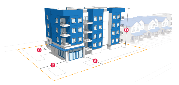
B. Dimensional Standards: The following table is a summary of key district-specific dimensional standards. Complete dimensional standards, including standards for accessory structures, are included in Part 7.4.2 (Dimensional Standards) and Section 7.3.304 (Accessory Uses).
Density and Lot Standards [1] | Single-Family Attached | Multi-Family | Non-residential | |
Density and Lot Standards [1] | Single-Family Attached | Multi-Family | Non-residential | |
Residential density range of area included in Land Use Plan [2] | 15-30 du/ac | N/A | ||
Lot area (minimum) | 1,000 sf per du | N/A | N/A | |
Lot width (minimum) | 16 ft per du | N/A | N/A | |
Setbacks (minimum) | ||||
A | Front [3] | 10 ft | 20 ft [1] | Min: 5 ft; Max: 20 ft |
B | Side | Interior: 1 ft minimum with6 ft combined both sides, or 0 ft if attached | 10 ft [1] | 10 ft |
Corner Lot - Side Street | 15 ft | 20 ft | ||
C | Rear | 10 ft | 20 ft [1] | 15 ft |
Detached Garage or Carport | 5 ft from property line adjacent to the alley or from the edge of any access easement | N/A | ||
Height (maximum) | ||||
D | Building height | 65 ft | 45 ft | |
Notes: [1] Setbacks for MF apply only to the perimeter of the parcel on the zone district boundary. [2] Proposed densities higher than 30 du/acre shall apply for a Planned Development zone district (see Part 7.2.7 (Planned Development Zone District) [3] Street-loaded garages are prohibited. | ||||
C. Additional Standards
1. Each Development Plan or Phasing Plan based off the approved Land Use Plan shall meet the established density of the district.
2. Each development shall comply with all applicable standards relating to Compact Lots in this UDC.
3. Reference Part 7.3.3 for additional use-specific standards. (Ord. 23-03)
PART 3 MIXED-USE ZONE DISTRICTS
SECTION:
7.2.301: OR: Office Residential
7.2.302: MX-N: Mixed-Use Neighborhood Scale
7.2.303: MX-T: Mixed-Use Transition
7.2.304: MX-M: Mixed-Use Medium Scale
7.2.305: MX-L: Mixed-Use Large Scale
7.2.306: MX-I: Mixed-Use Institutional
7.2.307: FBZ: Form-Based Zone (Regulating Plan District)
A. Purpose: The OR district accommodates a mix of residential uses, low intensity office uses, and compatible low-intensity commercial uses. Land uses are as indicated in Table 7.3.2-A (Base and NNA-O District Use Table). OR zone districts are intended to generally located at the edges of, or internal to, a residential neighborhood, at a local street intersection with a collector or arterial street. OR zone districts are intended to accommodate a limit mixed of non-residential uses that will have minimal impact on nearby residential neighborhoods and have safe and convenient pedestrian and bicycle access. The layout of permitted use types shall be as shown in a Land Use Plan approved pursuant to Section 7.5.514 (Land Use Plan).

B. Dimensional Standards: The following table is a summary of key district-specific dimensional standards. Complete dimensional standards, including standards for accessory structures, are included in Part 7.4.2 (Dimensional Standards) and Section 7.3.304 (Accessory Uses).
Table 7.2.3-A OR: Lot and Building Standards |
Table 7.2.3-A OR: Lot and Building Standards | ||
District Standards | ||
District area (minimum) | N/A | |
Lot Standards | ||
Lot area (minimum) | 5,000 sf | |
Lot width (minimum) | 50 ft | |
Lot coverage (maximum) | 50% | |
Setbacks (minimum) [2] | ||
A | Front and side street frontages [1] | |
Minimum | 25 ft | |
B | Side - Interior | 5 ft |
Corner Lot - Side Street | 15 ft | |
C | Rear | 20 ft |
Height (maximum) | ||
D | Building height | 35 ft |
Notes: [1] Applies to both frontages of corner sites. [2] Pursuant to Section 7.4.905 (Street Frontage and Street Trees), if the landscape setback is greater than the setback listed in this table, the landscape setback prevails. | ||
C. Additional Standards:
1. When land is zoned into this zone district after the Effective Date, the Manager may require that a Land Use Plan be approved along with the rezoning. A Land Use Plan that integrates multi-family uses may qualify the development for incentives pursuant to Section 7.4.202 (Incentives).
2. Reference Part 7.3.3 for additional use-specific standards. (Ord. 23-03)
A. Purpose: The MX-N zone district provides opportunities for a compact mix of, for example, low intensity neighborhood-serving commercial, office, institutional, low-scale multi-family residential uses. Land uses are as indicated in Table 7.3.2-A (Base and NNA-O District Use Table). MX-N zone districts are generally located at the edges of, or internal to, a residential neighborhood, at a local street intersection with a collector or arterial street. MX-N zone districts are intended to maintain the scale of the adjacent neighborhood, to avoid establishments so large that they serve as destinations for persons from outside the neighborhood, and to have safe and convenient pedestrian and bicycle access. The layout of permitted use types shall be as shown in a Land Use Plan approved pursuant to Section 7.5.514 (Land Use Plan).

B. Dimensional Standards: The following table is a summary of key district-specific dimensional standards. Complete dimensional standards, including standards for accessory structures, are included in Part 7.4.2 (Dimensional Standards) and Section 7.3.304 (Accessory Uses).
District Standards | ||
District area (minimum) | N/A | |
Lot Standards | ||
Lot area (minimum) | N/A | |
Lot width (minimum) | N/A | |
Setbacks (minimum) [2] | ||
A | Front and side street frontages [1] | |
Minimum | 5 ft | |
Maximum | 20 ft | |
B | Side - Interior | 10 ft |
Corner Lot - Side Street | 20 ft | |
C | Rear | 15 ft |
Height (maximum) | ||
D | Building height | 45 ft |
Other Standards | ||
Front parking setback (minimum) | 20 ft | |
Notes: [1] Applies to both frontages of corner sites. [2] Pursuant to Section 7.4.905 (Street Frontage and Street Trees), if the landscape setback is greater than the setback listed in this table, the landscape setback prevails. | ||
C. Additional Standards:
1. When land is zoned into this zone district after the Effective Date, the Manager may require that a Land Use Plan be approved along with the rezoning. A Land Use Plan that integrates multi-family uses may qualify the development for incentives pursuant to Section 7.4.202 (Incentives).
2. Reference Part 7.3.3 for additional use-specific standards. (Ord. 23-03)
A. Purpose: The MX-T zone district accommodates, for example, colleges and universities and uses customarily associated within and in close proximity to those institutions, including commercial, office, institutional, and residential. Land uses are as indicated in Table 7.3.2-A: Base and NNA-O District Use Table. MX-T zone districts are intended to encourage a walkable urban design with green space that is supportive of pedestrian and bicycle-friendly land uses and compatible with the scale of nearby residential neighborhoods. The layout of permitted use types shall be as shown in a Land Use Plan approved pursuant to Section 7.5.514 (Land Use Plan).

B. Dimensional Standards: The following table is a summary of key district-specific dimensional standards. Complete dimensional standards, including standards for accessory structures, are included in Part 7.4.2 (Dimensional Standards) and Section 7.3.304 (Accessory Uses).
Table 7.2.3-C MX-T: Lot and Building Standards |
Table 7.2.3-C MX-T: Lot and Building Standards | ||
Lot Standards | ||
Lot area (minimum) | Varies, see Table 7.4.2-C
| |
Lot width (minimum) | 50 ft | |
Setbacks (minimum) | ||
A | Front | 25 ft |
B | Side - Interior | 5 ft |
Corner Lot - Side Street | 15 ft | |
C | Rear | 25 ft |
Height (maximum) | ||
D | Building height | 60 ft |
Notes: [1] If no sidewalk exists, the distance is measured from 5 ft behind the curb line. | ||
C. Additional Standards:
1. When land is zoned into this zone district after the Effective Date, the Manager may require that a Land Use Plan be approved along with the rezoning. A Land Use Plan that integrates multi-family uses may qualify the development for incentives pursuant to Section 7.4.202 (Incentives).
2. Reference Part 7.3.3 for additional use-specific standards. (Ord. 23-03)
A. Purpose: The MX-M zone district accommodates a mix of, for example, commercial, retail, office, multi-family residential, and civic uses. Land uses are as indicated in Table 7.3.2-A: Base and NNA-O District Use Table. MX-M zone districts are intended to accommodate the development of new activity centers in emerging growth areas, as well as to promote the adaptive reuse or redevelopment of single-use commercial centers that are vacant or underused, or of other obsolete buildings or properties. Activities and uses within MX-M zone districts may be horizontally or vertically mixed based on their density and intensity but should be organized in a compact pattern that promotes pedestrian activity, provides a variety of outdoor gathering spaces, supports multimodal access and circulation, and minimizes impacts on established residential neighborhoods. The layout of permitted use types shall be as shown in a Land Use Plan approved pursuant to Section 7.5.514 (Land Use Plan).

B. Dimensional Standards: The following table is a summary of key district-specific dimensional standards. Complete dimensional standards, including standards for accessory structures, are included in Part 7.4.2 (Dimensional Standards) and Section 7.3.304 (Accessory Uses).
District Standards | ||
District area (minimum) | 2.5 ac | |
Lot Standards | ||
Lot area (minimum) | N/A | |
Lot width (minimum) | N/A | |
Setbacks (minimum) [2] | ||
A | Front and side street [1] | |
Minimum | 20 ft | |
Maximum | Subject to Land Use Plan or Development Plan | |
B | Side - Interior | 20 ft |
Corner Lot - Side Street | 30 ft | |
C | Rear | 15 ft |
Height (maximum) | ||
D | Building height | 50 ft |
Other Standards | ||
Front parking setback (minimum) | 20 ft | |
Notes: [1] Applies to both frontages of corner sites. [2] Pursuant to Section 7.4.905 (Street Frontage and Street Trees), if the landscape setback is greater than the setback listed in this table, the landscape setback prevails. | ||
C. Additional Standards:
1. When land is zoned into this zone district after the Effective Date, the Manager may require that a Land Use Plan designating the percentage of land in the zone district to be occupied by residential or nonresidential uses be approved along with the rezoning. A Land Use Plan that integrates multi-family uses may qualify the development for incentives pursuant to Section 7.4.202 (Incentives).
2. Reference Part 7.3.3 for additional use-specific standards. (Ord. 23-03)
A. Purpose: The MX-L zone district accommodates a high-intensity mix of, for example, commercial, retail, office, hotels, restaurants, entertainment, and multifamily residential uses. Land uses are as indicated in Table 7.3.2-A: Base and NNA-O District Use Table. MX-L zone districts typically serve the City as a whole and have significant traffic generation potential. Some MX-L zone districts may also include uses that have a regional draw. Uses in MX-L zone districts may be mixed horizontally or vertically mixed depending on their density and intensity. MX-L zone districts should be organized to promote synergy among uses, combine destinations, support more effective transit service, and provide viable pedestrian and bicycle access and circulation. MX-L zone districts should have direct access to existing or planned major transportation facilities and be designed to promote compatibility with adjacent land uses. The layout of permitted use types shall be as shown in a Land Use Plan approved pursuant to Section 7.5.514 (Land Use Plan).

B. Dimensional Standards: The following table is a summary of key district-specific dimensional standards. Complete dimensional standards, including standards for accessory structures, are included in Part 7.4.2 (Dimensional Standards) and Section 7.3.304 (Accessory Uses).
District Standards | ||
District area (minimum) | 10 ac | |
Lot Standards | ||
Lot area (minimum) | N/A | |
Lot width (minimum) | N/A | |
Setbacks (minimum) [1] | ||
A | Front and side street | N/A |
B | Side - Interior | N/A |
Corner Lot - Side Street | N/A | |
C | Rear | N/A |
Height (maximum) | ||
D | Building height | General: 65 ft Lots with arterial frontage: 85 ft |
Other Standards | ||
Front parking setback (minimum) | 20 ft | |
Notes: [1] Pursuant to Section 7.4.905 (Street Frontage and Street Trees), if the landscape setback is greater than the setback listed in this table, the landscape setback prevails. | ||
C. Additional Standards:
1. When land is zoned into this zone district after the Effective Date, the Manager may require that a Land Use Plan that designates the percentage of land that may be occupied by residential or nonresidential uses. A Land Use Plan that integrates multi-family uses may qualify the development for incentives pursuant to Section 7.4.202 (Incentives).
2. Reference Part 7.3.3 for additional use-specific standards. (Ord. 23-03)
A. Purpose: The MX-I zone district is intended to provide a framework for the development of, for example, unique cultural, resort, recreational, educational, or institutional developments that may attract visitors from both within and outside the Colorado Springs metropolitan area, and for complex institutional campuses such as colleges, universities, and research centers that promote economic development, workforce development, and tourism in the City. The layout of permitted use types shall be as shown in a Land Use Plan approved pursuant to Section 7.5.514 (Land Use Plan). Land uses are as indicated in Table 7.3.2-A: Base and NNA-O District Use Table.
B. Dimensional Standards: The following table is a summary of key district-specific dimensional standards. Complete dimensional standards, including standards for accessory structures, are included in Part 7.4.2 (Dimensional Standards) and Section 7.3.304 (Accessory Uses).
District Standards | ||
District area (minimum) | N/A | |
Lot Standards | ||
Lot area (minimum) | N/A | |
Lot width (minimum) | N/A | |
Setbacks (minimum) [2] | ||
A | Front and side street | |
Minimum | N/A | |
Maximum | Subject to Land Use Plan or Development Plan | |
B | Side - Interior | 20 ft |
Corner Lot - Side Street | 30 ft | |
C | Rear | 20 ft |
Height (maximum) | ||
D | Building height | 65 ft |
Other Standards | ||
Front parking setback (minimum) | 20 ft | |
Notes: [1] For single-family detached dwellings, the dimensional standards of the R-1 6 zone district (see Table 7.4.2-A
) apply. For two-family dwellings, the dimensional standards of the R-2 district apply (see Table 7.4.2-A
) apply. For all other residential uses, the dimensional standards of the R-5 zone district (see Table 7.4.2-A
) apply. [2] Pursuant to Section 7.4.905 (Street Frontage and Street Trees), if the landscape setback is greater than the setback listed in this table, the landscape setback prevails. | ||
C. Additional Standards
1. When land is zoned into this MX-I zone district after the Effective Date, approval of a Land Use Plan pursuant to Section 7.5.514 (Land Use Plan) is required prior to any development on the land. Lands zoned into the former SU or PCR zone districts prior to the Effective Date shall remain subject to any plans, conditions, or restrictions applicable under the pre-existing zoning or related zoning and land use approvals, but do not need to obtain approval of a Land Use Plan unless the Manager determines that the proposed development is of a size or intensity that was not anticipated, or creates potential impacts on the surrounding areas that were not considered, at the time of prior zoning or Land Use Plan approval. (Ord. 23-03)
Loading...