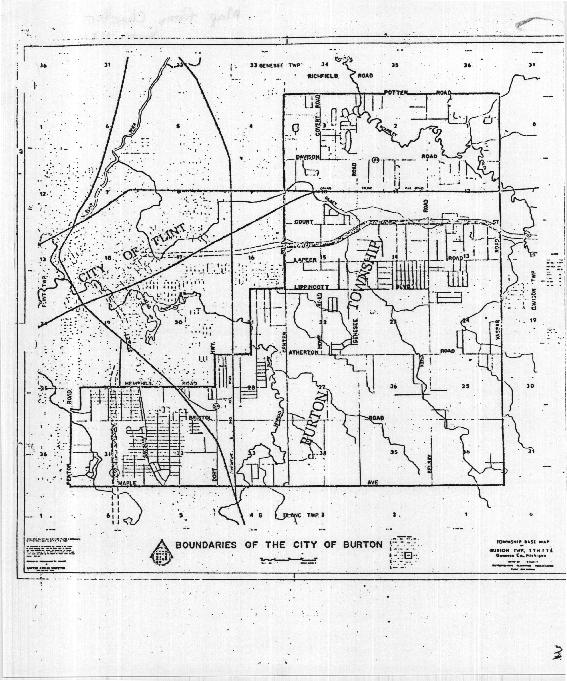
(a) The following described territory, together with all territories that may be annexed thereto, or detached therefrom, that may be made from time to time, shall constitute the territory of the City of Burton, and shall be subject to the municipal control thereof:
Beginning at the Northeast corner of Section 1, T7N, R7E, thence Southerly along the East lines of Sections 1, 12, 13, 24, 25, and 36, T7N, R7E, to the Southeast corner of said Section 36; thence Westerly along the South lines of Sections 36, 35, 34, 33, 32, and 31, T7N, R7E, to the Southwest corner of said Section 31; thence Northerly along the West lines of Sections 31 and 30, T7N, R7E, to a point on an extended line passing from a point on the East line of Lot 1 of the recorded plat of Burton Gardens 30 feet North of the Southeast corner of said Lot 1 through a point on the West line of said Lot 1, 44 feet North of the Southwest corner of said Lot 1; thence Southeasterly along said extended line to a point on the West line of said Lot 1, 44 feet North of the Southwest corner of said Lot 1; thence Southeasterly along said extended line to a point on the West line of said Lot 1, 44 feet North of the Southwest corner of said Lot 1; thence continuing Southeasterly to a point on the East line of said Lot 1, 30 feet North of the Southeast corner of said Lot 1; thence Southerly along a line common to Outlot B and Lots 1, 2 and 3 of said Burton Gardens to the Southwest corner of said Outlot B; thence Easterly along the Southerly line of said Outlot B to its Southeast corner; thence Northerly along the Easterly line of said Outlot B to its Northeast corner; thence Northerly along the extension of said East line of Outlot B to a point on the North line of the South 1/2 of the Southwest fractional 1/4 of said Section 30, T7N, R7E; thence Northerly along the East line of the West 1/2 of the Northwest 1/4 of the Southwest 1/4 of Section 30, T7N, R7E; to the East and West 1/4 line of said Section 30; thence Easterly along the East and West 1/4 lines of Sections 30 and 29, to the East 1/4 corner of said Section 29, T7N, R7E; thence Northerly along the West line of Section 28, T7N, R7E, to the Northwest corner of said Section 28; thence Easterly along the North line of said Section 28 to the North 1/4 corner of said Section 28; thence Northerly along the North and South 1/4 Line of Section 21 to the North 1/4 corner of said Section 21, T7N, R7E; thence Easterly along the North line of Section 21 to the Northeast corner of said Section 21; thence Northerly along the West lines of Sections 15, 10, and 3, T7N, R7E, to the Northwest corner of said Section 3; thence Easterly along the North lines of Sections 3, 2, and 1 to the point of beginning.
(b) Upon annexation or detachment of territory, the boundaries shall be deemed thereby to be changed without amendment of this section.
(c) The Clerk shall maintain and keep available in his office for public inspection an official description and map of the boundaries of the city, as the same shall exist from time to time.
Loading...