(A) Definition. Riparian corridors are those linear natural landscape systems, which have economic, biological, ecological or visual values for the community. Within the city, riparian corridors located along naturally occurring drainage channels have been identified as critical environmental resources within the community. These corridors form important visual and recreational opportunities for the community, which in-turn create economic value when correctly preserved as amenities within developed parcels.
(B) Intent. This section is provided to govern the preservation of all existing landform/topographic conditions and vegetative cover within identified environmental corridors. RIPARIAN CORRIDORS, identified in the environmental/landscape framework plan, are defined as those natural drainage channels having tree canopy or other vegetative cover, and/or soils generally associated with continuous or intermittent drainage or flooding. For purposes of the plan, riparian corridors have been identified by visual means, using current aerial photographs that indicate tree canopy cover over or within natural drainage channels.
(C) Applicability. This section shall apply to any land disturbance or construction of any structure within any area designated as a riparian corridor as set forth in the environmental/landscape framework plan, the boundaries of which are more specifically set forth in the plan’s map appendix. To the extent that a parcel is only partially subject to the riparian corridor designation, only structures or land disturbance on that portion of the site shall be subject to this section.
(D) Procedures. Land disturbance and construction of any structure governed by this section is prohibited, except as may be specifically permitted by special use permit issued pursuant to §§ 158.240 through 158.243, 158.255 through 158.257, 158.270 through 158.282 of this chapter and this subchapter, and subject to the additional standards established in this section. If construction is proposed as part of a planned use, no separate special use permit is needed.
(E) Standards. No special use permit shall be granted pursuant to this section, except in conformance with the standards established in the environmental/landscape framework plan, and the standards established in §§ 158.095 through 158.102 of this chapter, as applied to the riparian corridor. The issuance of a special use permit shall require maximum preservation of vegetation and tree canopy, and shall include mitigation conditions to ensure that any disturbance within the riparian corridor is minimized and adequately restored and mitigated where disturbance cannot be reasonably avoided.
(F) Requirements. If it is determined that a portion of a riparian corridor is located on the site of a proposed subdivision or development proposal, the petitioner shall comply with the following.
(1) Site plan. Each applicant must show any riparian areas on the required site plan. The city may determine the applicability of specific criteria where existing riparian corridor tree canopy and other vegetative cover is less than 300 feet in width.
(2) Clearing restrictions. In no case may existing trees or other vegetation be removed within riparian corridors identified as part of a submitted site plan without prior written approval by the city. Such review and approval by the city is required in order to maintain a city-wide functional storm water management system and important environmental functions of these areas.
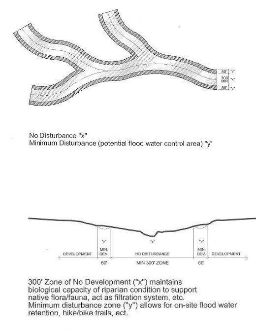
(G) Riparian Corridor “x” Zone. The “x” zone of the riparian corridor is a critical zone of vegetative cover and soil conditions that provides for drainage channel bank stability and erosion control. Current tree canopy along most of the identified riparian corridors occurs within the width of the “x” zone, and in addition to the erosion control created by the vegetation within the zone, the zone creates primary wildlife habitat and movement corridors. The zone’s tree canopy, a remnant of the forests which covered much of the city’s landscape prior to agricultural use and development, creates important visual qualities for the city. Development and preservation criteria for the “x” zone include:
(1) A minimum width of 300 feet, measured 150 feet (horizontal or plan dimension) perpendicular from centerline of drainage channel on both slopes;
(2) Development of parcels shall not directly or indirectly impact the “x” zone area of the riparian corridors;
(3) All vegetative cover and landform/ topographic conditions must be retained in a natural condition during development and post-development activities;
(4) Storm water management basins, devices or strategies shall not be deployed within the “x” zone of the riparian corridor unless other storm water mitigation strategies are deemed impractical by the city; and
(5) Use of the “x” zone shall be primarily resource preservation. Limited use of the zone for hike and bike trails may be approved by the city.
(H) Riparian Corridor “y” Zone. The “y” zone of the riparian corridor is another critical zone of vegetative cover and soil conditions that shall be preserved or re-established outside of the “x” zone described above. The primary purpose of the “y” zone is to provide additional biological filtration of sediment and contaminants carried by storm water run-off into natural drainage channels, and to further buffer or slow storm water time of concentration as storm flows enter natural drainage channels. Development and preservation criteria for the “y” zone include:
(1) Minimum width of 50 feet, measured 50 feet (horizontal or plan dimension) perpendicular from outside boundary of “x” zone as described above;
(2) Development of parcels shall not directly or indirectly impact the “y” zone area of the riparian corridors, except for uses noted below. Otherwise, all vegetative cover and landform/ topographic conditions must be retained in a natural condition during development and post-development;
(3) Use of the “y” zone shall be limited to non-structural or natural storm water management strategies, non-vehicular circulation systems or dedicated parkland/ open space developed with native plant species; and
(4) Storm water management basins, devices or strategies deployed within the “y” zone shall be reviewed and approved by the city.
(I) Alternative compliance. Upon request by the applicant, the Director may consider and approve alternatives to full compliance with the development guidelines contained in this subchapter if the associated environmental and functional impact of the environmental corridor is mitigated to the maximum extent feasible by the alternative methods. Any proposed alternatives must be shown on the site plan and certified by a qualified professional knowledgeable in the area of natural drainage systems.
(Ord. 3474, passed 9-5-2006)