(a) Words used in this Code are used in their ordinary English usage.
(b) For the purpose of this Planning and Zoning Code, the following terms shall have the meaning herein indicated:
(1) Abut. To physically touch or border upon; or to share a common property line but not overlap. See adjacent.
(2) Adjacent. See abut.
(3) Adult Care Facility. A facility providing personal care services to adults (typically elderly). Such services may include assistance in daily living activities and self-administration of medicine, and preparation of special diets.
A. An adult family home: Providing accommodations for 3 to 5 unrelated adults.
(4) Applicant. See Developer.
(5) Bank. An establishment providing retail banking, credit, and/or mortgage services. This term shall not include a currency exchange, a payday loan agency or a title loan agency.
(6) Basement or cellar. That portion of a building located at least partly underground but having at least 1/2 of its clear floor-to-ceiling height below the average grade of the adjoining ground.
(7) Berm. An earthen mound designed to provide visual interest, screen undesirable views, and/or decrease noise.
(8) Buffer or buffer yard/area. A combination of physical space and vertical elements, such as plants, berms, fences, or walls, the purpose of which is to separate and screen incompatible land uses from each other.
(9) Building. Any structure, which is permanently affixed to the land, having one or more floors and a roof supported by columns or walls, which is completely enclosed and is designed or intended for the shelter or protection of persons, animals, or property. For the purposes of this definition, the ground shall be considered a floor.
A. Building, accessory: A subordinate building detached from, but located on the same lot as, the principal or main building, the use of which is incidental and accessory to the principal building or use and which is constructed subsequent to the principal building or principal use of the land, such as but not limited to a detached garage, storage shed, etc.
B. Building, principal: A building occupied by the principal use of the lot on which said building is located.
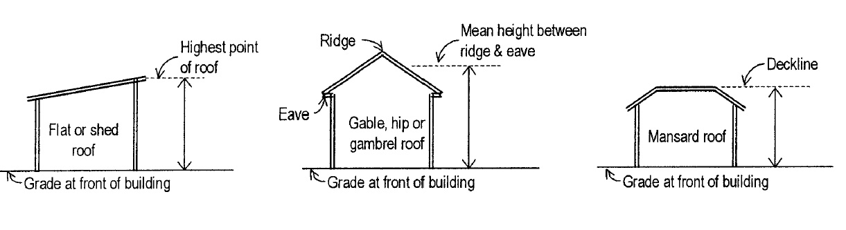
(10) Building height. The vertical distance, measured from the average elevation of the finished grade at the front of the building to the highest point of the roof for a flat or shed roof; to the decklines of mansard roofs; and to the mean height between eaves and ridge for gable, hip and gambrel roofs. Where a building is located on sloping terrain, the height shall be measured from the average finished grade at the building walls. See Figure 1.
Figure 1.
Building Height
 |
(11) Caliper. The American Association of Nurserymen standard for trunk measurement of nursery stock. Caliper of the trunk shall be taken at diameter-at-breast-height.
(12) Carport. A roofed structure, with a foundation, that provides space for the parking of vehicles and enclosed on not more than three (3) sides.
(13) Cellar. See Basement.
(14) Church. See Place of Worship.
(15) Civic center. Grouping of Moreland Hills municipal and government facilities, including but not limited to administrative offices, the Fire Department, the Police Department, service facilities and associated parks and plazas.
(16) Commercial vehicle. Any self-propelled or towed vehicle used on public streets in intrastate or interstate commerce to transport passengers or property that meets any of the following specifications:
A. The vehicle is a panel or box truck, meaning a truck with its cargo area completely enclosed, that has a gross vehicle weight rating or gross combination weight rating of 10,001 pounds or more. Gross combination weight rating meaning the specific weight determined by the manufacturer to be the maximum weight of a loaded tow vehicle and its attached loaded trailer.
B. The vehicle is designed to be a medium duty or heavy duty tow truck.
C. The vehicle is designed to transport sixteen (16) or more passengers, including the driver.
D. Any other vehicle, not specified above, that has a gross vehicle weight rating or gross combination weight rating of 14,001 pounds or more.
E. Any vehicle, with a gross vehicle weight rating or gross combination weight rating of 10,001 pounds or more, with words or other markings designed to draw attention to the vehicle or containing a commercial message.
F. The vehicle is used in the transportation of hazardous materials in a quantity requiring placarding under the regulations issued by the United States secretary of transportation under the "Hazardous Materials Transportation Act," 88 Stat. 2156 (1975), 49 U.S.C.A. 1801, as amended.
(17) Common area/property. Any land area and/or facilities that is held in common ownership by the residents through a homeowners' association, community association or other legal entity, or which is held by the individual members of a condominium association as tenants-in-common.
(18) Compliance, Certificate of Zoning. An official statement asserting that a given building, other structure or parcel of land is in compliance with the provisions of all applicable codes or ordinances, or is a lawfully existing nonconforming building or use and, hence, may be occupied and used lawfully for the purposes designated thereon.
(19) Conservation Development. An area of land to be planned and developed as a single residential development, in which the minimum lot size and setback requirements may be modified to achieve particular design objectives, while maintaining the same overall density limitations of the district in which the conservation development is located, and allowing for the flexible arrangement and clustering of dwellings.
(20) Contour. An imaginary line connecting all points with the same elevation above or below a fixed base point whose elevation is known.
(21) Density. The number of dwelling units permitted per acre of land.
(22) Density, gross. Gross density means the number of dwelling units permitted per acre of total land area.
(23) Developer. Any individual, subdivider, firm, association, syndicate, partnership, corporation, trust or any other legal entity commencing proceedings under this Planning and Zoning Code to effect a development of land hereunder for himself or for another. The terms applicant, owner, and/or agent of the owner are synonymous with "developer."
(24) Development. Any building, construction, renovation, mining, extraction, grading, dredging, filling, excavation, or drilling activity or operation; any material change in the use or appearance of any structure or in the land itself; the division of land into parcels; any change in the intensity or use of land, such as an increase in the number of dwellings units in a structure or a change to a commercial or industrial use from a less intense use.
(25) Diameter-at-breast-height. The diameter of a tree trunk measured in inches at a height 4.5 feet above ground. If a tree splits into multiple trunks below 4.5 feet, the trunk is measured at its most narrow point below the split.
(26) Driveway. A private access way used by vehicles and pedestrians for access to a parking space, garage, dwelling, or other structure.
(27) Dwelling, attached single-family. Dwelling units that are structurally attached to one another, side by side, and erected as one building, each dwelling unit being separated from the adjoining unit or units by a party wall without openings extending from the basement floor to the roof and each such building being separated from any other building by space on all sides, and including such elements as separate ground floor entrances, services and attached garages.
(28) Dwelling, cluster single-family detached. A dwelling unit which is designed and used exclusively by one family and separated from all other dwelling units by open space from ground to sky, which is grouped with other dwelling units on a site in an arrangement. The cluster one-family detached dwelling does not need to be located on its own subdivided lot, but shall comply with all applicable requirements. Also known or referred to as a dwelling.
(29) Dwelling, single-family detached. A dwelling unit designed and used for one (1) family situated on a lot having a front, side, and rear yard and separated from all other dwelling units by open space from ground to sky. Also known or referred to as a dwelling.
(30) Dwelling unit. One or more habitable rooms comprising living, dining, sleeping room or rooms, storage closets, as well as space and equipment for cooking, bathing and toilet facilities, all used by only one (1) family.
(31) Established street grade. The elevation of the street, road or highway, established by the Village of Moreland Hills, measured at the center line of such road, street or highway in front of the lot or parcel of land to which the provisions of this Planning and Zoning Code apply.
(32) Exotic animals. Any wild animal not indigenous to Ohio or any reptile not indigenous to Ohio. (Examples: lions, tigers, elephants, alligators, crocodiles, etc.) Additionally, omnivorous and carnivorous Ohio species such as bear, deer, elk, wolves, coyote, fox, turkey, lynx, and bobcat are deemed exotic. Any animal that is commonly sold by a bona fide commercial pet shop is not considered to be an exotic animal.
(33) Façade. That portion of any exterior elevation on the building extending from grade to the top of the parapet, wall, or eaves and the entire width of the building elevation.
(34) Family. "Family means one (1) or more persons occupying a dwelling unit and living as a single housekeeping unit, provided that unless all members are related by blood, marriage, adoption, guardianship, or are foster children, no such family shall contain over four (4) unrelated persons.
(35) Family day care home. A residence used to provide childcare as detailed below:
A. Type B. A permanent residence of the day care provider in which child day care is provided for 1 to 6 children at one time. No more than 3 of these children shall be under two years of age at one time.
(36) Fence. Any structure composed of wood, iron, steel, masonry, stone or any other materials which are erected in such a manner and in such a location so as to in whole or in part enclose, secure, provide privacy, decorate, define the scope or limits of, or otherwise enhance all or an identifiable part of any premises.
(37) Floor area, gross. The sum of the gross horizontal areas of all floors of a building, measured from the exterior faces of the exterior walls of a building or from the center line of a common wall separating two (2) or more units of a building, including accessory storage areas located within selling or working space, but not including space in cellars or basements, space in machinery penthouses or floor space used for accessory off-street parking. However, if the cellar or basement is used for non-residential purposes, it shall be counted as floor area in computing off-street parking requirements.
(38) Floor area, net. The total of all floor areas of a building, excluding stairwells and elevator shafts, equipment rooms, interior vehicular parking; and all floors below the first or ground floor, except when used or intended to be used for human habitation.
(39) Foster child. A person who is placed in a dwelling unit by the Ohio Department of Job and Family Services or another institution or agency, licensed and/or approved by an appropriate State-regulating agency to place foster individuals.
(40) Garage. A building, or part thereof, used or intended to be used for the parking and storage of vehicles.
(41) Gasoline service station. A facility limited to retail sales to the public of gasoline, motor oil, lubricants, motor fuels, and minor automobile accessories. In addition, such a facility may provide minor vehicle servicing, minor repairs, and maintenance, including engine rebuilding but not reconditioning of motor vehicles, collision services such as body, frame, or fender straightening and repair, or overall painting of automobiles.
(42) Grade. The vertical alignment of a surface of land, as it exists or as rendered by cut and/or fill activities.
(43) Grade, finished. The elevation of the surface of the ground adjoining the building after construction of required parking area or driveways and after the planting of lawn and shrubbery, or other required improvements to open spaces.
(44) Grade, natural. The elevation of the undisturbed natural surface of the ground prior to any excavation or fill.
(45) Grading. The rearrangement of the earth's surface by stripping, cutting, filling, or stockpiling of earth or land, including the land in its cut or filled condition, to create new contours or grades.
(46) Habitable space or room. Spaces in a building for living, sleeping, eating and cooking. Bathrooms, toilet rooms, closets, storage or utility areas and similar areas are not considered habitable space.
(47) Home occupation. Any use or profession conducted entirely within a dwelling and carried on primarily by the inhabitants thereof, which use is clearly incidental and secondary to the use of the dwelling for dwelling purposes and does not change its character.
(48) Homeowners' association. A community association that is organized within a development in which individual owners share common interests and responsibilities for open space, landscaping, or other such common facilities.
(49) Improvements. The term means street pavement or resurfacing, curbs, gutters, sidewalks, water lines, sewer lines, storm drains, street lights, flood control and drainage facilities, utility lines, landscaping, and other related matters normally associated with the development of raw land into building sites.
(50) Landscaped area. An area that is permanently devoted to and maintained for the growing of trees, shrubs, grass or other plant material.
(51) Loading space, off-street. An area located completely outside of any public right-of-way and on the same lot with a building or contiguous to a group of buildings, for the temporary parking of vehicles entering the premises for loading or unloading merchandise or materials.
(52) Lot. A parcel of land of sufficient size to meet minimum zoning requirements for use, coverage and area and to provide such yards/ setback and other open spaces as are required by this Planning and Zoning Code. A lot may consist of the following:
A. A single lot of record;
B. A portion of a lot of record;
C. A combination of complete lots of record, of complete lots of record and portions of lots of record, or portions of lots of record.
(53) Lot area. See lot size.
(54) Lot coverage. That portion of a lot, which when viewed directly above, would be covered by builidngs and structures, parking and loading areas and other surfaces that are impermeable or substantially impervious to water.
(55) Lot coverage by building. That portion of a lot that is occupied by any principal and/or accessory buildings, excluding unroofed steps, patios, terraces, and similar structures. Building coverage is measured from exterior wall to exterior wall.
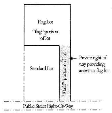
(56) Lot, flag. A lot so shaped and designed that the main building site area is set back from the public street on which it fronts and access to the public street right-of-way is by a narrow private access drive also referred to as the "staff". See Figure 2 below.
Figure 2
Illustration of Flag Lot
 |
(57) Lot frontage. That portion of the lot extending along the street right-of-way.
(58) Lot line. The boundary line defining the limits of the lot. Lot line is synonymous with "property line."
A. Lot line, front: The line separating an interior lot from the street right-of-way or private street on which the lot fronts. On a corner lot, the street right-of-way with the least amount of street frontage shall be the front lot line.
B. Lot line, rear: The lot line opposite and most distant from the front lot line; or in the case of triangular or otherwise irregularly shaped Lots, a line 10 feet in length entirely within the lot, parallel to and at a maximum distance from the front lot line.
C. Lot line, side: Any lot line other than a front or rear lot line.
(59) Lot of record. A lot which is part of a subdivision, the part of which has been recorded in the office of the County Recorder, or a lot or parcel of land described by metes and bounds, the description of which was recorded, prior to adoption of this Planning and Zoning Code.
(60) Lot size. The total horizontal area contained within the lot lines exclusive of any portion of the right-of-way of any public street or private street pavement or easement.
(Ord. 2012-21. Passed 7-11-12.)
(61) Lot types. Terminology used in this Planning and Zoning Code with reference to corner lots and interior lots is as follows:
A. Lot, corner. A lot which adjoins the point of intersection or meeting of two (2) or more streets and in which the interior angle formed by the street lines is 135 degrees or less.
B. Lot, interior. A lot abutting or with frontage on only one street.
(Ord. 2018-03. Passed 4-11-18.)
(62) Lot width. The horizontal distance between the side lot lines, measured at right angles to the lot depth at the front setback line.
(63) Lot, zoning. A parcel of land not separated by street or alley that is designated by its owner or developer at the time of applying for a zoning certificate, as a tract all of which is to be used, developed, or built upon as a unit under single ownership. Unless the context clearly indicates otherwise, such as a nonconforming lot, the term "zoning lot" is used synonymously with "lot" herein.
(64) Nonconformity. A lot, use of land, building, use of buildings, or use of buildings and land in combination lawfully existing at the time of enactment of this Planning and Zoning Code or its amendments, which do not conform to the current regulations of the district or zone in which it is situated or other regulations in this Planning and Zoning Code.
A. Nonconforming building. A building existing lawfully when this Planning and Zoning Code, or any amendment thereto, became effective, but which does not conform to the current regulations governing buildings and structures of the district in which it is located.
B. Nonconforming lot. A lot lawfully existing on the effective date of this Planning and Zoning Code or any amendment thereto, which on such effective date, does not conform to the current lot area, access, lot width, frontage, or other requirements of the district in which it is located.
C. Nonconforming use: Any building or land lawfully occupied by a use on the effective date of this Planning and Zoning Code or any amendment thereto, which does not conform to the current use regulations of the district in which it is situated.
(65) Office, Administrative/Business/Professional. An establishment within which specific services are conducted with other businesses, individuals, organizations or corporate customers, generally on a contractual basis, and not involving the retail sales of merchandise on the premises for walk-in traffic from the street.
(66) Office, Medical/Dental. Facilities which provide diagnoses, minor surgical care and outpatient care on a routine basis, but which do not provide overnight care or serve as a base for an ambulance service. Medical/dental facilities are operated by doctors, dentists, or similar practitioners licensed by the State of Ohio. Emergency treatment is not the dominant type of care provided at this facility. Medical/dental office includes establishments providing support to medical professionals and patients, such as medical and dental laboratories, blood banks, oxygen, and miscellaneous types of medical supplies and services.
(67) Open Space. The portion of the open space in a development that is of sufficient size and shape to meet the minimum zoning requirements and on which further development is restricted.
(68) Outdoor storage. The storage of goods, materials, merchandise or vehicles in an area outside of a building or structure in the same place for more than 24 hours.
(69) Owner. See Developer.
(70) Park, public. A tract of land, designated and used by the public, for active and/or passive recreation.
(71) Parking facilities. An outdoor paved area made up of marked or unmarked parking spaces and associated access drives where motor vehicles may be stored for the purpose of temporary off-street parking. Also known as a parking area or parking lot.
(72) Parking space, off-street. An open or enclosed area, defined by painted lines, raised curbs or a combination thereof except for when designated for use by one-family dwellings, outside the public street right-of-way that is used for the parking or temporary storage of registered and licensed motor vehicles
(73) Performance guarantee. A financial deposit, approved by the Law Director, to ensure that all improvements, facilities, or work required will be completed and/or maintained in conformance with the approved plan.
(74) Performance standard. A criterion established to control enclosure, dust, smoke, fire and explosive hazards, lighting, glare and heat, noise, odor, toxic and noxious matter, vibrations and other conditions created by or inherent in uses of land or buildings.
(75) Place of Worship. A building or structure used for public worship. The words "place of worship" includes the words "church," "house of worship," "chapel," "synagogue," "temple," and "mosque" and their uses and activities that are customarily related.
(76) Plan, development. A plan prepared to scale accurately showing, with complete dimensions, the boundaries of the site, the location of buildings; landscaping; parking areas; access drives; signs; outdoor storage areas; and any other features that comprise a proposed development.
A. Preliminary Development Plan: Drawings and maps including all the elements set forth in Chapter 1127.
(77) Plan, Preliminary. A drawing for the purpose of study of a subdivision and which, if approved, permits proceeding with the preparation of the final plat.
(78) Plan, plot. A plan of a lot, drawn to scale, showing the actual measurements, the size and location of any existing structure or structures to be erected, the location of the lot in relation to abutting streets, and other such information.
(79) Plat. A map of a lot, tract or subdivision on which the lines of each element are shown by accurate distances and bearings.
(80) Plat, final. The final map of all or a portion of a subdivision which, if approved, may be recorded.
(81) Porch. A roofed open structure that projects from the front, side or rear wall of a building.
(82) Project boundary. The boundary defining the tract(s) of land that is included in a proposed development to meet the minimum required project area required in this Code. The term "project boundary" shall also mean "development boundary."
(83) Public hearing. An official meeting called by the Village Council, the Planning Commission, or the Board of Appeals, duly noticed, which is intended to inform and obtain public comment or testimony, prior to the governing body rendering a decision.
(84) Public service facility. A structure and/or site providing for public services such as power plants or substations, water treatment plants or pumping stations, sewage disposal or pumping plants, and other similar public service structures and uses operated by a public utility or by a municipal or other governmental agency.
(85) Recreational vehicle/equipment. Recreational vehicle/equipment includes snowmobiles, floats, rafts, trailers - open or enclosed, boats and boat trailers, including normal equipment to transport the same, recreational equipment as determined by the Building Inspector and also includes any of the following recreational vehicles as each is hereinafter defined:
A. Travel Trailer. A vehicular, portable structure built on a chassis, designed to be used as a temporary dwelling for travel, recreational and vacation uses.
B. Pick-up Camper. A structure designed primarily to be mounted on a pick-up truck chassis and with sufficient equipment to render it suitable for use as a temporary dwelling for travel, recreational and vacation uses.
C. Motor Home. A portable dwelling designed and constructed as a integral part of a self-propelled vehicle.
D. Folding Tent Trailer. A canvas folding structure mounted on wheels and designed for travel and vacation use.
(86) Recreational Space & Associated Facilities. Recreational uses, including recreation areas, hiking trails, and similar facilities, used by nonprofit, governmental, or similar entities, dedicated to open space maintenance, preservation, education and management as well as associated, accessory facilities used by nonprofit, governmental, or similar entities, dedicated to open space maintenance, preservation, education and management.
(87) Residential facility. A facility licensed by the Ohio Department of Mental Health that provides room, board, personal care, supervision, habilitation services and mental health services, in a family setting, to one or more persons with mental illness or severe mental disabilities. A foster family home is a residential facility that provides the services listed above for five (5) or fewer mentally retarded or developmentally disabled persons.
(88) Restaurant, indoor dining. An establishment where food and drink are prepared and served to the consumer within the principal building.
(89) Restaurant, outdoor dining. An establishment where food and drink are prepared inside the establishment and consumed outside the principal building in an area adjacent to the principal building.
(90) Retail Establishment. An establishment engaged in the selling of goods or merchandise to the general public for personal or household consumption, and rendering services incidental to the sale of such products. Such an establishment is open to the general public during regular business hours and has display areas that are designed and laid out to attract the general public. In determining a use to be a retail use, the proportion of display area vs. storage area and the proportion of the building facade devoted to display windows may be considered.
(91) Right-of-way. A strip of land or the air space above it taken, dedicated, or otherwise recorded as an irrevocable right-of-passage for use as a public way. In addition to the roadway, it normally incorporates the curbs, tree lawns, lawn strips, sidewalks, water and sewer lines, lighting, and drainage facilities, and may include special features (required by the topography or treatment) such as grade separation, landscaped areas, viaducts, and bridges and the air space above the surface.
(92) Right-of-way line. The line between a lot, tract, or parcel of land and a contiguous public street, and demarcating the public right-of-way. "Right-of-way line" also means "street line."
(93) Roadway. The pavement measured between curbs, that portion of a right-of-way available for vehicular travel, including parking lanes.
(94) School, specialty/personal instruction. A facility primarily teaching usable skills that prepare students for jobs within a specific trade or a facility providing instruction on social and religious customs and activities, performing arts and/or sports. Such facilities may include beauty schools, dance instruction centers, cooking schools and martial arts studios. This term does not include health club.
(95) Setback. The required minimum horizontal distance between a lot line and the nearest portion of a building, pavement, parking areas, wetland, waterway or structure as established by this Planning and Zoning Code.
(96) Setback Line. A line established by this Planning and Zoning Code generally parallel with and measured from the lot line, defining the minimum distance a building, structure, parking area, pavement or other area shall be located from the said lot or thoroughfare/right-of-way line, except as may be provided in this Planning and Zoning Code.
(97) Service establishment, business. An establishment providing services to business establishments on a fee or contract basis, including, but not limited to, advertising and mailing services, employment services, business equipment and furniture sales or rental, photocopy services, protective services, or similar services.
(98) Service establishment, personal. An establishment providing services that are of a recurring and personal nature to individuals. This term includes, but is not limited to, a barber shop, beauty salon, shoe repair shop, seamstress, tailor, fortune teller, and tanning salon. This term does not include a health club or repair shop for household items.
(99) Single housekeeping unit. Single housekeeping unit means common use and access to all living and eating areas, bathrooms, and food preparation and serving areas.
(100) Stable. All buildings designed or used for boarding or transfer stables, all private barns, carriage houses, sheds, pens, coops, or any building or outdoor space used for the feeding or sheltering of animals.
(101) Street. An avenue, highway, road, thoroughfare, boulevard, parkway, easement or other way, public or private, proposed for vehicular traffic and any existing State, county, township or Village street or way shown upon a plat heretofore duly approved, filed and recorded in the office of the County Recorder. The term includes the land between the street right-of-way lines, whether improved or unimproved, and may comprise pavement, shoulders, gutters, sidewalks, division strips or other areas within the street lines. The term street is synonymous with road and highway.
(102) Street, collector. A street supplementary to and connecting arterial streets to local streets.
(103) Street, private. An area set aside to provide access for vehicular traffic within a development that is not dedicated or intended to be dedicated to the Village and that is not maintained by the Village.
(104) Street, public. A right-of-way intended to be used for travel by the public, improved for such purpose, and accepted for perpetual maintenance. Included is the land between the street right-of-way lines, whether improved or unimproved, and may comprise pavement, shoulder, gutters, sidewalks, division strips or other areas within the right-of-way lines.
(105) Structure. Anything that is constructed on or under the ground or attached or connected to the ground, included but not limited to: buildings, barriers, bridges, bulkheads, bunkers, chimneys, fences, garages, outdoor seating facilities, patios, platforms, decks, pools, poles, tanks, tents, towers, sheds, signs and walls; excluding parking facilities, driveways, access drives, and trailers and other vehicles whether on wheels or other supports.
(106) Structure, accessory. A structure on the same lot with, and of a nature customarily incidental and subordinate to, the principal building, such as but not limited to fences, flagpoles, gazebos, etc. See also structure.
(107) Structural alteration. Any change or rearrangement in the supporting members of a building, such as beams, girders, bearing walls, columns or partitions or any increase in the area or cubical contents of the building.
(108) Subdivision. "Subdivision" means:
A. The division of any parcel of land shown as a unit or as contiguous units on the last preceding tax roll, into two or more parcels, sites or lots for the purpose, whether immediate or future, of transfer of ownership, provided, however, that the sale or exchange of parcels between adjoining lot owners, where such sale or exchange does not create additional building sites, shall be exempted; or
B. The improvement of one or more parcels of land for residential, commercial or industrial structures or groups of structures involving the division or allocation of land for the opening, widening or extension of any street or streets, except private streets serving industrial structures; and the division or allocation of land as open spaces for common use by owners, occupants or lease holders or as easements for the extension and maintenance of public sewer, water, storm drainage or other public facilities.
(109) Use. The purpose for which land, a building or structure is arranged, designed, intended, maintained or occupied; or any occupation, activity, or operation carried on in a building or structure or on land.
A. Use, accessory. A use located on the same lot with the principal use of building or land, but incidental and subordinate to and constructed subsequent to the principal use of the building or land.
B. Use, conditional. A use permitted in a district, other than a principal use permitted by right, which is allowed only under certain conditions as set forth in Chapter 1177, Conditional Use Regulations, and which requires conditional use approval by the Planning Commission and the Village Council, in accordance with the standards and procedures set forth in Chapter 1129, Certificates.
C. Use, permitted. A use that is authorized by this Planning and Zoning Code as either a use permitted by right or an accessory use.
D. Use permitted by right. A permitted use that is approved administratively when it complies with the standards and requirements set forth in the Planning and Zoning Code, the approval of which does not require a public hearing.
E. Use, principal. The primary or main use or activity of a building or lot, which may be a conditional use or a use permitted by right.
F. Use, temporary. A use that is established for a fixed period of time with the intent to discontinue such use upon the expiration of such time and does not involve the construction or alteration of any permanent Structure.
(110) Variance. A grant to a property owner authorizing the property owner to vary from the literal terms of the relevant regulations.
(111) Vehicular Use Area. An area for storage of any and all types of vehicles whether such vehicles are self propelled or not, and all land designed to be traversed by vehicles.
(112) Yard. An open space on the same lot with a principal building or structure extending between the lot line and the extreme front, rear or side wall of the principal building or structure.
A. Yard, corner side. On a corner lot, the yard between the principal building and the side lot line adjacent to the street and extending from the front yard to the rear lot line.
B. Yard, front. The area across the full width of the lot between the front of the principal building and the front line of the lot.
C. Yard, rear. The area across the full width of the lot between the rear of the principal building and the rear line of the lot.
D. Yard, side. The area between the principal building and the side line of the lot extending from the front wall to the rear wall of the principal building.
(113) Zoning Certificate. A document issued by the Building Inspector authorizing the construction or alteration of a building or structure and/or use of a lot or structure in accordance with this Planning and Zoning Code.
(114) Zoning Map. An accurate map, or maps, depicting the Village of Moreland Hills, Ohio, and indicating the boundaries of the zoning districts established by this Planning and Zoning Code. The Zoning Map, or maps, shall include any other maps indicating the Village's development policies. The Zoning Map, or maps, may also be known as the Official Zoning Map.
(Ord. 2012-21. Passed 7-11-12.)