For the purposes of this Chapter, the following terms shall have the following meanings:
ABUTTING - having a common border with, or being separated from such common border by a right-of-way, alley or easement.
ACCESS DRIVE - a public or private drive providing vehicular access to and between parking areas for more than 2 parking spaces within a land development; or any drive servicing 2 or more units of occupancy on a single lot.
ACCESSORY - additional, something extra or complementary.
ACT 247 - the Pennsylvania Municipalities Planning Code (“MPC”) as heretofore and hereafter amended.
ADJOINING LOT - a lot that shares all or part of a common point or line with another lot.
AGRICULTURAL LAND/AREAS - land used exclusively for the cultivation of the soil, the production of crops or livestock, or the science of forestry; also, land diverted from agricultural use by an active federal farm program, provided the diverted land has a conservation cover of grass, legume, trees or wildlife shrubs. Agriculture land may include, to a minor degree, farmsteads inhabited by the cultivator of the land, housing for farm employees, and land used for preparation of agricultural products by the cultivator of the land.
APPLICANT - a landowner and/or developer, as hereinafter defined, including his heirs, successors and assigns, who filed an application for subdivision and/or land development.
APPLICATION FOR DEVELOPMENT - every application, whether preliminary or final, required to be filed and approved prior to start of construction or development, including, but not limited to, an application for a building permit, for the approval of a subdivision plat or plan, or for the approval of a development plan.
AVERAGE DAILY TRAFFIC (ADT) - computed by application of a day of the week by month factor to an average 24-hour traffic count. Such information is available in the latest volume of the Pennsylvania Department of Transportation traffic data collection and factor development report.
BLOCK - land surrounded on all sides by streets (measure at the right-of-way) or other transportation or utility rights-of-way, or by physical barriers such as bodies of water or public open spaces.
BMPs - best management practices.
BUFFER - a strip of land with landscaping, fences and/or walls located between 2 uses, or between 1 use and a public right-of-way, that is intended to mitigate negative impacts, such as visual and noise, of the more intense use on the less intense use or on the public right-of-way.
BUFFER AREA - a strip of land within a public right-of-way which may include signage, street trees, and curbs, gutters or swales.
BUILDING - any enclosed or open structure, other than a boundary wall or fence, occupying more than 4 square feet of area and/or having a roof supported by columns, piers or walls.
BUILDING, ACCESSORY - a detached, subordinate building, use of which is customarily incidental and subordinate to that of the principal building, which is located on the same lot as that occupied by the principal building. Farm buildings not intended for habitation are considered to be accessory buildings.
BUILDING, PRINCIPAL - a building that is enclosed within exterior walls or firewalls, and is built, erected and framed of component structural parts. The principal building is also designed for housing, shelter, enclosure and support of individuals, animals or property of any kind, and is a main structure on a given lot.
BUILDING SETBACK LINE - a line within a lot, designated on a plan as the minimum required distance between any structure and the adjacent street centerline, or right-of-way line and/or side and rear property lines as specified by any applicable zoning ordinance.
CAPACITY - the maximum number of vehicles that can be expected to pass over a given section of roadway or on a specific lane.
CARTWAY - the portion of a street right-of-way, paved or unpaved, customarily used by motorized and non-motorized vehicles in the regular course of travel over the street.
CLEAR SIGHT TRIANGLE - an area of unobstructed vision at street intersections defined by lines of sight between points at a given distance from the intersection of the street right-of-way lines.
COMMON OPEN SPACE - a parcel or parcels of land or an area of water, or a combination of land and the water, within the development site, designed and intended for the use or enjoyment of residents of the development, not including streets, off-street parking areas, and areas set aside for public facilities.
COMMONWEALTH - Commonwealth of Pennsylvania.
COMMUNITY WATER SUPPLY - a public water supply, regulated by the Department of Environmental Protection, which supplies potable water for use by 15 or more connections or 25 or more people.
COMPREHENSIVE PLAN - the official public document prepared and adopted in accordance with the Pennsylvania Municipalities Planning Code, consisting of maps charts and textual material, that constitutes a policy guide to decisions about the physical and social development of the Borough.
CONCENTRATED BUILDING AREA - presently undeveloped land that has the physical characteristics and available infrastructure to accommodate more intense development.
CONDOMINIUM - a form of ownership of real property, as defined in the Pennsylvania Uniform Condominium Act of 1980, which includes a multiple unit land development in which there is a system of separated ownership of individual units of occupancy and undivided interest of land and common facilities.
CONTIGUOUS - lots are contiguous when at least 1 boundary line of 1 lot touches a boundary line or lines of another lot.
COUNTY - Perry County, Pennsylvania.
DEDICATION - the deliberate appropriation of land by its owner for general public use.
DEED - a written instrument whereby an estate in real property is conveyed.
DENSITY, GROSS - the number of dwelling units or units of occupancy per gross lot area acre (i.e., the 11 total area within the deeded property lines without exception).
DENSITY, NET - the number of dwelling units or units of occupancy per net lot area acre (i.e. the total area within the deeded property lines exclusive of existing street right-of-way).
DESIGNATED GROWTH AREA (DGA) - a region within a county or counties described in a municipal or multi-municipal plan that preferably includes and surrounds a city, borough or village, and within which residential and mixed-use development is permitted or planned for densities of 1 unit to the acre or more, commercial, industrial and institutional uses are permitted and institutional uses are permitted and planned for, and public infrastructure services are provided or planned. (Per MPC)
DETENTION BASIN - a reservoir that temporarily contains storm water runoff and releases it gradually into a watercourse or storm water facility.
DEVELOPER - any landowner, agent of such landowner, or tenant with the permission of such landowner, including a firm, association, organization, partnership, trust, company, or corporation as well as an individual, for whom subdivision or land development plans are being or have been made.
DEVELOPMENT PLAN - the provisions for development, including a planned residential development, a subdivision plat or plan and/or a land development plat or plan, all covenants relating to use, location and bulk of buildings and other structures, intensity of use or density of development, streets, ways and parking facilities, common open space and public facilities. The phrase “provisions of the development plan” when used in this Chapter shall mean the written and graphic materials referred to in this definition.
DRAINAGE EASEMENT- the land required for the installation of storm sewer or drainage facilities, or required along a natural stream or watercourse for preserving the channel and providing for the flow of water therein, or to safeguard the public against flood damage.
DRIPLINE - a line marking the outer edges of the branches of the tree.
DRIVEWAY - a private drive providing vehicular access between a street or access drive and a parking area for 4 or less residential units of occupancy.
DWELLING - a structure or portion thereof that is used exclusively for human habitation.
DWELLING UNIT - One or more rooms, designed, occupied, or intended for occupancy as separate living quarters, with cooking, sleeping, and sanitary facilities provided within the dwelling unit for the exclusive use of a single family maintaining a household.
EASEMENT - a strip of land granted for limited use of property by the landowner for a public or quasi-public or private purpose, and within which the owner of the property shall not have the right to make use of the land in a manner that violates the right of the grantee.
ELEVATION - the vertical alignment of a surface, as it exists or as it is made by cut and/or fill.
ENGINEER - a professional engineer licensed as such in the Commonwealth of Pennsylvania.
ENVIRONMENTAL COVENANT - a servitude arising under an environmental response project which imposes activity and use limitation. (On December 18, 2007, Governor Ridge signed the Uniform Environmental Covenants Act (UECA) into law as Act 68 of 2007. Section 6517(a)(1) of UECA requires the use of Environmental Covenants whenever engineering controls or institutional controls are necessary to demonstrate attainment of an Act 2 remediation standard for any cleanup conducted under any applicable Pennsylvania environmental law. The covenant provides a tool to ensure that the conditions allowing for a risk-based cleanup will continue in the future).
ENVIRONMENTALLY SENSITIVE AREAS - an area not suitable for development that includes hedge rows/fence rows, floodplains, floodplain soils, steep slopes, wetlands, and riparian areas.
EROSION - the detachment and movement of soil or rock fragments or the wearing away of the land surface by water, wind, ice and gravity.
EXCAVATION - removal or recovery by any means whatsoever of soil, rock, mineral, mineral substances, or organic substances other than vegetation from water or land, on or beneath the surface thereof, or beneath the land surface, whether exposed or submerged.
EXISTING WOODED AREA - a biological community of 1 acre or more dominated by woody plants and trees that have at least 25 trees per acre with at least 50% of those trees having a 2-inch or greater caliper at 4.5 feet above the ground and larger.
FILL - sand, gravel, earth, or other materials of any composition whatsoever placed or deposited by humans.
FLAGPOLE - a narrow extension of property on a lot or parcel from the buildable area of a lot to the public right-of-way, and which is not part of the lot area, but serves as access to the lot or parcel. See also “Lot”.
FLOODPLAIN AREA - a relatively flat or low land area which is subject to partial or complete inundation from an adjoining or nearby stream, river or watercourse; and/or any area subject to the unusual and rapid accumulation of surface waters from any source for the purpose of this Chapter see also “One Hundred Year Flood”.
FLOOR ELEVATION - the elevation of the lowest level of a particular building, including the basement.
FOOTCANDLE - Unit of light intensity on a plane (assumed to be horizontal unless otherwise specified), stated in lumens per square foot and measurable with an illuminance meter, a.k.a. light meter.
FRONTAGE - that portion of the property which abuts and is measured along the street right-of-way line.
FULLY SHIELDED - a light constructed in such a manner that all light emitted by the fixture, either directly from the lamp or a diffusing element, or indirectly by reflection or refraction from any part of the luminaire, is projected below the horizontal.
FUTURE ACCESS STRIP - a right-of-way reserved for the future improvement of a street.
GEOLOGIST - a professional geologist registered by the Commonwealth of Pennsylvania.
GLARE - excessive brightness in the field of view that causes loss in visual performance or annoyance, so as to jeopardize health, safety or welfare.
GOVERNING BODY - Marysville Borough Council.
HISTORIC FEATURE - any district, site, building structure or object that meets one or more of the following criteria:
(1) Is listed or may be determined to be eligible to be listed on the National Register of Historic Places either individually or as a contributing resource.
(2) Is recognized by the Historical Society of Perry County, Perry Historians or on any officially adopted borough inventory of historic resources and is determined by a qualified historic preservation professional to retain the historic characteristics that qualified it.
(3) Is determined by a qualified historic preservation professional to be historically or architecturally significant.
HORIZON YEAR - the projected completion year of a development, including construction of required improvement.
ILLUMINANCE - the quantity of light measured in footcandles or lux.
IMPERVIOUS SURFACE - material that is impenetrable and unable to absorb water, including, but not limited to, buildings, structure and paved areas.
IMPROVEMENT - physical changes to the land, including, but not limited to, buildings, streets, curbs, gutters, streetlights and signs, water mains, hydrants, sanitary sewer mains, including laterals to the street right-of-way lines, storm drainage lines, storm water management structures, walkways, recreational facilities, open space improvements, shade trees, buffer or screen plantings, and all other additions to the tract which are required by ordinance or are deemed necessary to result in a complete subdivision or land development in the fullest sense of the term.
IMPROVEMENT, PUBLIC - improvements for which the Borough may ultimately assume the responsibility for maintenance and operation, or which may affect an improvement for which Borough responsibility is established.
INDIGENOUS SPECIES - plants which have not been introduced by man and thrive in an area where it is considered native.
INFILL - development of land accessible to infrastructure that is generally surrounded by development and has been bypassed, remained vacant, and/or is underused.
INFLUENCE AREA - an area that contains 80% or more of the trips that will be attracted to a development site.
INVASIVE SPECIES - plants which grow quickly and aggressively, spreading, and displacing other plants. Invasive typically are introduced into a region far from their native habitat.
LAND DEVELOPMENT - the development of property as specified below:
(1) The improvement of 1 or 2 or more contiguous lots, tracts or parcels of land for any purpose involving:
(a) A group of 2 or more residential or non-residential buildings, whether proposed initially or cumulatively, or a single non-residential building on a lot or lots, regardless of the number of occupants or tenure.
(b) The division or allocation of land or space, whether initially or cumulatively, between or among 2 or more existing or prospective occupants by means of, or for the purpose of, streets, common areas, leaseholds, condominiums, building groups or features.
(2) A subdivision of land.
(3) “Land Development” shall not include
(a) The conversion of an existing single-family detached dwelling or single-family semi-detached dwelling into not more than 3 residential units, unless such units are intended to be a condominium.
(b) The addition of an accessory building, including farm buildings, on a lot or lots subordinate to an existing principal building.
(c) The addition or conversion of buildings or rides within the confines of an enterprise that would be considered an amusement park. For purpose of this sub clause, an amusement park is defined as a tract or area used principally as a location for permanent amusement structures or rides. This exclusion shall not apply to newly acquired acreage by an amusement park until initial plans for the expanded area have been approved.
LANDOWNER - the legal or beneficial owner or owners of land, including the holder of an option or contract to purchase, whether or not such option or contract is subject to any condition, a lessee, if he is authorized under the lease to exercise the rights of the landowner, or other person having a proprietary interest in land.
LANDSCAPE ARCHITECT - a landscape architect registered by the Commonwealth of Pennsylvania.
LANDSCAPING - acting with the purpose of meeting specific criteria regarding uses of outside space, including ground cover, buffers and shade trees.
LEVEL-OF-SERVICE - a measure of the effect of traffic on the capacity of a road.
LIGHT TRESPASS - light emitted by a lighting installation which extends beyond the boundaries of the property on which the installation is sited.
LOT- a designated parcel, tract, or area of land established by plat, subdivision, or as otherwise permitted by law, to be separately owned, used, developed, or built upon.
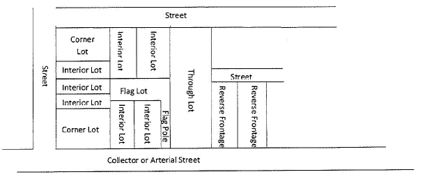
LOT, CORNER - A lot situated at the intersection of 2 or more streets with frontage on 2 or more adjacent sides.
LOT, FLAG - a parcel of land created by a subdivision or partition which includes a narrow projection or “flagpole” to the public right-of-way.
LOT, INTERIOR - a lot whose side lot lines do not abut upon any street.
LOT, REVERSE FRONTAGE - an interior lot with front and rear street frontage, where vehicular access occurs on only the street of lesser intensity.
LOT, THROUGH - a street that fronts on 2 parallel streets or that fronts on 2 streets that do not intersect at the boundaries of the lot.
LOT AREA - the area contained within the property lines of the individual parcel of land, excluding space within the street right-of-way. The lot area includes the area of any utility easement or storm water management facility, but does not include the “flagpole” of a flag lot unless otherwise specified in the zoning ordinance.
LOT FRONTAGE - that portion of a lot abutting on the street right-of-way and regarded as the front of the lot.
LOT LINE - a line of record bounding a lot that divides one lot from another lot or from or private street or any other public space.
LOT LINE MARKER - a metal plate, pin, permanent stone or concrete monument used to identify lot line intersections.
LOT OF RECORD - a lot which is a part of a subdivision, the plan of which was recorded; or a parcel of land, the deed of which was recorded in the office of the Perry County Recorder of Deeds prior to the adoption of the subdivision and land development ordinance.
LUMEN - as used in the context of this Chapter, the light-output rating of a lamp (light bulb).
LUMINANCE - the physical and measurable quantity of light that corresponds to the brightness of a surface (e.g., a lamp, luminaire, reflecting material) in a specific area and measurable with a luminance meter or light meter.
MANUFACTURED HOME OR MOBILE HOME - a transportable, single-family dwelling intended for permanent occupancy contained in 1 unit, or in 2 or more units designed to be joined into 1 integral unit capable of again being separated for repeated towing, which arrives at a site complete and ready for occupancy except for minor and incidental unpacking and assembly operations. All manufactured or mobile homes shall meet construction standards set by the United States Department of Housing and Urban Development.
MOBILE HOME LOT - a parcel of land in a mobile home park, improved with the necessary utility connections and other appurtenances necessary for the erections thereon of a single mobile home.
MOBILE HOME PAD - that part of a mobile home lot that is being reserved for the placement of the mobile home.
MOBILE HOME PARK - a parcel or contiguous parcels of land which has been so designated and improved that it contains 2 or more mobile home lots for the placement thereon of mobile homes.
MODIFICATION - a process for alleviating specific requirements imposed by this Chapter, as described in § 22-301.
MONUMENT, SURVEY - a permanent concrete or stone monument used to identify property lines or street lines.
MULTIMODAL TRAVEL LANE - accommodating various modes of power assisted surface transportation including but not limited to bicycles, non-motorized scooters, Segway, and horse drawn buggies; but excluding a vehicle which is required to be registered in order to be operated on a highway/street.
MULTI-MUNICIPAL PLAN - a plan developed and adopted by any number of contiguous municipalities, including a joint municipal plan as authorized by the Pennsylvania Municipalities Planning Code or a regional plan.
MUNICIPAL ENGINEER - a professional engineer licensed as such in the Commonwealth of Pennsylvania, duly appointed as the engineer for the municipality.
MUNICIPAL SOLICITOR - the licensed attorney designated by the Borough Council to furnish legal assistance for the administration of this Chapter.
MUNICIPALITY - Borough of Marysville, Pennsylvania.
NEW DEVELOPMENT - a project involving the construction, reconstruction, redevelopment, conversion, structural alteration, relocation or enlargement of an structure, or any use or extension of land. New developments have the potential of increasing the requirements for capital improvements, requiring either approval of a plan pursuant to this Chapter, the issuance of a building permit, or connection to the public water or sanitary sewer system.
NON-SITE TRAFFIC - vehicle trips passing within the study area as defined in the traffic impact study that do not enter or exit the site and are generally the result of through traffic and traffic generated by other developments.
OFF-SITE - any premises not located within the area of the property to be subdivided or developed, whether or not in the common ownership of the applicant for subdivision or land development approval.
OFFICIAL MAP - a map adopted by ordinance pursuant to the Pennsylvania Municipalities Planning Code and recorded in the office of the Perry County Recorder of Deeds.
ONE HUNDRED-YEAR FLOOD - a flood that, on the average, is likely to occur once every 100 years (i.e., that has 1% chance of occurring each year, although the flood may occur in any year). For the purpose of this Chapter the floodplain area is an identified as Zone A (area of special flood hazard) in the flood insurance study (6-19-2009). Accompanying maps of the most recent revisions are issued by the Federal Emergency Management Agency.
PARCEL - See “Lot”.
PEAK HOUR - the hour during which the heaviest volume of traffic occurs on a road.
PEDESTRIAN WAY - a right-of-way, publicly or privately owned, intended for human movement.
PENNSYLVANIA MUNICIPALITIES PLANNING CODE (MPC) - adopted as Act 247 of 1968, as Act 247 of 1968, as reenacted and amended. This act enables municipalities to plan for, and regulate community development with subdivision and land development ordinance content.
PERVIOUS MATERIAL - any material (that would allow water to pass through at a rate at least equal to the previous ground cover e.g., porous pavement, and preform or prefabricated blocks which would permit water to penetrate) and as approved by the Borough Engineer.
PHASES - as defined under the MPC, Article V, as stages or sections of development.
PLAN - a drawing, together with supplementary data, that describes a subdivision or land development.
(1) As-Built Plan - engineering documents drawn to scale showing the constructed dimensions, capacities and materials of a structure or other land improvement. An as-built drawing differs from design drawings and construction drawings, which are design-oriented documents prepared prior to construction rather than a depiction of what has been constructed.
(2) Final Plan - a complete and exact subdivision and/or land development plan, including all supplementary data, designed in accordance with the requirements of § 22-406.
(3) Lot Line Relocation Plan - a plan for the relocation of a lot line in accordance with § 22-404.
(4) Preliminary Plan - a subdivision and/ or land development plan which is designed in accordance with the requirements of § 22-405, and is prepared for consideration prior to submission of a final plan.
(5) Sketch Plan - an informal plan, not necessarily to exact scale, indicating salient existing features of a tract and its surroundings, with the general layout of proposal prepared in accordance with the requirements of § 22-402.
PLANNING COMMISSION - the Marysville Borough Planning Commission.
PLANNING COMMISSION, COUNTY - the Perry County Planning Commission.
PLANT, NATIVE - a plant which exists naturally, without human intervention, in a specific geographic area.
PLANT, NON-NATIVE - any plant species that has been introduced by humans and now grows independently of cultivation. A subset of non-native species are the invasive species.
PLAT - the map or plan of a subdivision or land development, whether preliminary or final.
PUBLIC HEARING - a formal meeting held pursuant to public notice, intended to inform and obtain public comment, prior to taking action in accordance with this Chapter and/ or the Pennsylvania Municipalities Planning Code.
PUBLIC MEETING - a forum held pursuant to notice under the act of July 3, 1986 (P.L. 388, No. 84), known as the “Sunshine Act”.
PUBLIC NOTICE - a notice published once a week for 2 successive weeks in a newspaper of general circulation in the Borough. Such notice shall state the time and place of the meeting and the particular nature of the matter to be considered. The first publication shall not be more than 30 days and the second publication shall not be less than 7 days from the date of the hearing.
REDEVELOPMENT - public and/ or private investment made to re-create the fabric of an area by renovating previously developed land. Replacing, remodeling, or reusing existing buildings and structures to accommodate new development.
RETENTION BASIN - a reservoir designed to retain stormwater runoff with its primary release of water being through the infiltration of said water into the ground.
RIGHT-OF-WAY - the total width and length of any land reserved or dedicated as a street, alley or pedestrian way, or for any other public or private purpose.
RUNOFF - the surface water discharge and rate of discharge of a given watershed after a rain or snow event that does not enter the soil but flows off the surface of the land.
RURAL - land with density less than 1 unit per acre, including agricultural areas and natural resource areas.
SCREENING - planted or existing shrubs or trees, earthen mounds, or fencing located to obscure view or separate uses.
SEDIMENTATION - the process by which soil or other surface material is accumulated or deposited by wind, water or gravity.
SETBACK LINE - See “Building Setback Line”.
SEWAGE - a substance that contains the waste products or excrement or other discharge from the bodies of human beings or animals and noxious or deleterious substances being harmful to the public health, or to animal or aquatic life, or to the use of water for domestic water supply or for recreation. The term includes any substance which constitutes pollution under the Clean Stream Act.
SEWAGE FACILITIES - a system of sewage collection, conveyance, treatment, and disposal which will prevent the discharge of untreated or inadequately treated sewage or other waste into waters of this Commonwealth or otherwise provide for the safe and sanitary treatment and disposal of sewage or other waste as recognized by the Department of Environmental Protection.
(1) Public Sewage System - a publicly owned system of piping, tanks, or other facilities serving two or more lots, which uses a method of sewage collection, conveyance, treatment, and disposal other than renovation in a soil absorption area, or retention in a retaining tank.
(2) Individual On-Lot Sewage System - an individual sewage system which uses a system of piping, tanks or other facilities for collecting, treating or disposing of sewage into a soil absorption area or spray field or by retention in a retaining tank.
SIGHT DISTANCE - the length of road visible to the driver of a vehicle at any given point in the road when viewing is unobstructed by traffic.
SIGNIFICANT TREE - noninvasive tree with 18 inch minimum diameter measured 5 feet above grade.
SITE - the existing lot of record proposed for land development, including subdivision.
STEEP SLOPE - any property where the average slope exceeds 15%.
STORMWATER - water that surfaces, flows, or collects during and subsequent to rain or snowfall.
STORMWATER MANAGEMENT FACILITIES - those controls and measures (e.g., storm sewers, berms, terraces, bridges, dams, basins, infiltration systems, swales, watercourses and floodplains) used to implement a storm water management program.
STREAM - a body of water flowing in a channel within a defined bed and banks.
STREET - a strip of land, including the entire right-of-way, publicly or privately owned, serving primarily as a means of motorized and non-motorized vehicular and pedestrian travel, and furnishing access to abutting properties. This term shall include the terms avenue, boulevard, road, highway, freeway, parkway, lane, alley, underpass or any other way used for similar purposes. Streets shall conform to one of the following categories:
(1) Alley (Service Street) - a service road that provides secondary means of access to lots. Alleys are on the same level as a local street, and are used in cases of narrow lot frontages. Alleys shall be designed to discourage through traffic. Alleys may be designed as one-lane streets.
(2) Arterial - an interregional road in the street hierarchy system that carries vehicle traffic to and from the region as well as any through traffic. This street should be a controlled access street (designed to the capacity analysis of the intersection level of service (LOS).
(3) Collector - a street that provide connections with local and arterial streets. They may serve a traffic corridor connecting villages, small boroughs, shopping points, and mining and agricultural areas on an intra-county or municipal basis.
(4) Cul-De-Sac - a street with a single means of ingress and egress and having a turnaround. The design of the turnaround may vary.
(5) Local - this classification provides direct access to adjacent land and includes connections to farms, individual residences and commercial properties, and to higher classes of highway systems.
STREET LINE - the right-of-way line of any given street.
STREET, PRIVATE - a street not accepted for dedication by the Borough.
STRUCTURE - any man-made object having an ascertainable stationary location on or in land or water, whether or not affixed to the land.
SUBDIVISION - the division or re-division of a single lot, tract or parcel of land by any means into 2 or more lots, tracts, parcels or other divisions of land, including changes in existing lot lines for the purpose, whether immediate or future, of lease, partition by the court for distribution to heirs or devises, transfer of ownership, or building, or lot development.
SUBJECT TRACT - the site proposed for land development, including subdivision.
SUBSTANTIALLY COMPLETED - where, in the judgment of the Borough Engineer, at least 90% (based on the cost of the required improvements for which financial security was posted) of those improvements required as a condition for final approval have been completed in accordance with the approved plan, so that the project will be able to be used, occupied or operated for its intended use.
SUPER ELEVATION - the distance in height (elevation) between the inside and outside of a banked cartway.
SURVEYOR - an individual registered with the Commonwealth of Pennsylvania as authorized to measure the boundaries of tracts of land, establish locations, and perform the requirements of a survey.
SWALE - a wide shallow ditch that gathers or carries surface water.
TIE BAR - the symbol on a survey, plan, or plat shown as “Z” indicating common ownership of 2 adjacent lots or tracts.
TOPOGRAPHY - the relief features or surface configurations of an area of land.
TRACT - the term “tract” is used interchangeably with the term “lot,” particularly in the context or subdivision, where a “tract” is subdivided into several lots, parcels, units plots, condominiums, tracts or interests.
TRAIL - a marked or established path or route typically through a vegetated area. A type of thoroughfare that is intended for use primarily by pedestrians and not other forms of traffic such as motorized vehicles. They can be found in a wide variety of places, from towns or subdivision, to farmland, to wooded areas.
TREE PROTECTION ZONE - an area that is radial to the trunk of a tree in which no construction activity shall occur. The tree protection zone shall be the distance from the trunk to the drip line (a line marking the outer edges of the branches of the tree).
TRIP - a single or one-directional motorized and/ or non-motorized vehicle movement.
UNIT OF OCCUPANCY - an allocation of space within a building or structure that is independent of other such space and that constitutes a separate use. This shall include both fee simple ownership and leaseholds.
WATERCOURSE - a permanent topographic feature, whether natural or man-made, that serves to gather and carry flowing surface water such as a permanent or intermittent stream, a river, creek, brook, run or swale; and which measured by the width of the channel during normal high water.
WATERSHED - all land and water within the confines of a drainage basin.
WETLANDS - areas that are inundated or saturated by surface or groundwater at a frequency and duration sufficient to support, and that under normal circumstances do support, a prevalence of vegetation typically adapted for life in saturated soil conditions, including swamps, marshes, bogs and similar areas.
(Ord. 614, 5/11/2015)