The following terms or words, when capitalized herein, shall be interpreted or defined as indicated:
ACCESS DRIVE – A paved way or drive, whether on the same parcel as the primary use served thereby or by Right-of-Way on another parcel, providing a place and access for vehicular movement between a Street or Alley and an off-street parking area/facility for any use of land other than a single residential Unit of occupancy or agricultural use (farm) or between a Street or Alley and one or more Driveways.
ADJACENT PROPERTY – Property that is contiguous with, or directly across a public Street or other Right-of-Way from, the boundaries of any side of the subject property.
ALLEY – A minor Right-of-Way, publicly or privately owned, primarily for service access to the back or side of properties and not intended for general traffic circulation.
ASTM – ASTM International, originally known as the American Society for Testing and Materials (ASTM).
BERM – An earthen mound designed to create a visual interest on a site, screen undesirable views, reduce noise or provide a buffer between a use and adjoining properties, Streets, and adjacent uses.
BLOCK – A surface land area which is separated and distinguished from other surface land areas by visible physical boundaries such as Streets, railroads, rivers, extremely steep land, or other physical barriers.
BUILDING – Any Structure on a Lot having a roof supported by columns or walls and intended for the shelter, housing, or enclosure of Persons, animals, or chattels, and including covered porches or bay windows, and chimneys.
CARTWAY – That portion of a Street or Alley that is improved or intended for vehicular use excluding the shoulders.
CERTIFICATION – A signed statement appended to a Plan or other document whereby the signer represents that to the best of their knowledge and belief said Plan or document is true and correct and that the City may rely upon the accuracy thereof.
CITY – The City of Martinsburg, West Virginia.
CITY COUNCIL – City Council of the City of Martinsburg, West Virginia.
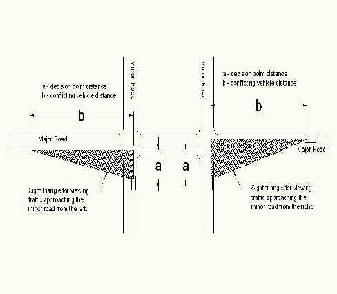
CLEAR SIGHT TRIANGLE – An area of unobstructed vision at Street Intersections defined by lines of sight between points at a given distance from the Intersection of the Street center lines (see Figure 1303-1).
CROSSWALK – A Right-of-Way, publicly or privately owned, intended to furnish access for pedestrians.
CUL-DE-SAC – A Street with access closed at one end and with a vehicular turn-around at the closed end. The length of a Cul-de-sac shall be measured from the centerline of the intersecting Street to the center of the turning circle.
CUT – An Excavation. The difference between a point on the original ground and designated point of lower elevation on the final grade. Also, the material removed in Excavation.
DEDICATION – The deliberate donation of land by its owner for any general and public, or limited public, use, reserving to the owner no other rights than such as are compatible with the full exercise and enjoyment of the public uses to which the property has been devoted.
DETENTION – The temporary storage of storm Runoff in a Stormwater Management practice with the goals of controlling Peak Discharge rates and providing gravity settling of pollutants.
DEVELOPER – The legal or beneficial owner or owners of a Lot or of any land included in a proposed Development, including the holder of an option or contract to purchase, or other Persons having enforceable proprietary interests in such land.
Figure 1303-1, Clear Sight Triangle
Source: American Association of State Highways and Transportation Officials (AASHTO) “A Policy on Geometric Design of Highways and Streets”
DEVELOPMENT – The physical alteration or improvement of improved or unimproved land, and/or Structures thereon, by human activity or action, or any change or expansion in use of land that would require such alteration or improvement to comply with the requirements of this Ordinance (assuming for purposes of such analysis that the change or expansion of use is deemed a Development). Development includes, without limitation, the following activities:
(1) Subdivision of land;
(2) Construction or alteration of Structures, Buildings, Roads, utilities, and other facilities;
(3) Installation of water, sewer (or septic), Stormwater Management, or other utility systems, facilities, or Improvements;
(4) Grading, dredging, Filling, paving, or Excavation;
(5) Deposit of refuse, debris, or Fill materials;
(6) Clearing of natural vegetative cover (with the exception of agricultural activities);
(7) A change or expansion in use of land that requires alteration or improvement of the land to comply with the requirements for landscape screening, parking, Impervious Coverage, and other provisions of this Ordinance applicable to the changed or expanded use; and
(8) Routine repair and maintenance of existing Improvements do not constitute Development.
DRAINAGE – The flow of water or liquid waste and the methods of directing such flow.
DRAINAGE EASEMENT – A legal right granted by a Landowner to a grantee allowing the use of private land for Stormwater Management purposes.
DRIVEWAY – A private travel way for Vehicles that provides access to a public Street or Road from a parking space, Garage, Dwelling, Structure or Use. Driveways shall be paved with asphalt or concrete.
EASEMENT – A right to use or control land owned by another (or an area above or below it) for a specified purpose.
ENGINEER, CITY – The duly authorized Engineer for the City of Martinsburg, West Virginia.
EROSION AND SEDIMENT CONTROL PLAN – A Plan that is designed to minimize Accelerated Erosion and Sediment Runoff at a site during construction activities.
EXCAVATION – Any act by which earth, sand, gravel, rock or any other similar material is dug into, Cut, quarried, uncovered, removed, displaced, relocated or bulldozed and shall include the conditions resulting therefrom.
FILL – Shall be defined as follows:
(1) Any act by which earth, sand, gravel or rock or any other material is placed, pushed, dumped, pulled, transported or moved to a new location above the stripped surface and shall include the conditions resulting therefrom;
(2) The difference in elevation between a point on the original ground and a designated point of higher elevation on the final grade; and
(3) The material used to make a Fill.
FINAL PLAN – The Plan and Plat submitted as part of a Final Subdivision and/or Land Development Application.
FINAL PLAT – The final version of the Plat submitted as part of a Final Subdivision and/or Land Development Application approved by the City Engineer/Planning Director or designee, which Plat has been stamped and signed by or on behalf of the Planning Commission and is to be recorded pursuant to Section 1305.05
.
FINAL SUBDIVISION AND/OR LAND DEVELOPMENT APPLICATION – The application for approval of a Final Plan & Plat for a Subdivision and/or Land Development, which application is prepared in accordance with, and contains the content specified in, Section 1305.05
.
FLOOD – A temporary inundation of normally dry land areas.
FLOODPLAIN – See definition of “Flood-Prone Area” below.
FLOOD-PRONE AREA – A relatively flat or low land area which is subject to partial or complete inundation from an adjoining or nearby stream, river or Watercourse; and/or any area subject to the unusual and rapid accumulation of surface waters from any source.
FRONTAGE – Abutting Lot boundary line that abuts a Public Street, Road, or highway, or rural Right-of-Way.
IMPERVIOUS AREA – Any portion of a Lot covered by material impenetrable by precipitation, including but not limited to Buildings, Structures and paved areas.
IMPERVIOUS COVER – Any natural or Person-made material utilized to cover, pave or re-surface any portion or area of a Lot whether permeable or impermeable excepting only soil, plants or vegetative coverings. Impervious Cover shall include, among other materials, any form or mixture of concrete, stone, asphalt, tar, porous pavement, or other substance designed and intended to alter the natural state of the land.
IMPERVIOUS COVERAGE – That portion of any Lot, tract or property covered by an Impervious Surface.
IMPERVIOUS SURFACE – A surface covered with Impervious Cover that prevents the percolation of water into the ground.
IMPROVEMENTS – Those physical changes to the land necessary to produce usable and desirable Lots from raw acreage including but not limited to: grading, paving, curb, gutter, storm sewers and drains, Improvements to existing Watercourses, sidewalks, Crosswalks, Monuments, water supply facilities, and sewerage disposal facilities.
INTERSECTION – A crossing of two or more roadways at grade, a crossover, or any at-grade connection with a roadway such as a commercial entrance.
KARST – A type of geology that is formed over limestone, dolomite or gypsum by solution of the rock and is characterized by closed depressions or Sinkholes, caves and underground Drainage.
LAND DEVELOPMENT – The Development of one or more Lots, tracts, or parcels of land by any means and for any purpose; provided that, for purposes of this Ordinance, the following shall not be considered a Subdivision or Land Development:
(1) Easements, Rights-Of-Way, or construction of private Roads for extraction, harvesting or transporting natural resources;
(2) Remodeling projects involving no change in use, and rehabilitation or renovation of single-family residences;
(3) Additions to an existing Structure requiring construction upon no more than 250 additional square feet of land and involving no change in use;
(4) The conversion of an existing single-family detached dwelling or single-family semidetached dwelling into not more than three (3) residential Units, unless such Units are intended to be a condominium;
(5) The addition of an accessory Building, including farm Buildings, on a Lot or Lots subordinate to an existing principal Building and involving no change in use; provided that, the added accessory Building contains no more than five hundred (500) square feet of floor area; and
(6) The addition or conversion of Buildings or rides within the confines of an existing amusement park. For the purposes of this subclause, an amusement park is defined as a tract or area used principally as the location for permanent amusement Structures or rides. This exclusion shall not apply to land not previously used as an amusement park.
Also, a Land Development is, collectively, the various Lots, tracts, or parcels subject to Development.
LAND DISTURBANCE OR LAND DISTURBANCE ACTIVITY – A Person-made change to the land surface that potentially changes its Runoff Characteristics including any clearing, grading, or Excavation associated with a construction activity regulated pursuant to the Clean Water Act and this chapter.
LAND DISTURBANCE PERMIT – A permit issued by the City of Martinsburg for the clearing, filling, excavating, grading, transporting of land, or for any combination thereof or for any purpose set forth by this Ordinance.
LANDOWNER – The legal or beneficial owner or owners of land including the holder of an option or contract to purchase (whether or not such option or contract is subject to any condition), a lessee if lessee is authorized under the lease to exercise the rights of the Landowner, or other Person having a proprietary interest in land.
LANDSCAPING – The planting of turf, trees, shrubs, and other appropriate vegetative materials and ground cover within the open areas of a Lot other than for agricultural purposes, and including the maintenance and replacement thereof, for the purposes of erosion control, retention of precipitation, protection against the elements and promotion of human comfort and welfare.
LICENSED LANDSCAPE ARCHITECT – Any Person who engages in the Practice of Architecture and is licensed by the West Virginia Board of Landscape Architects.
LOT – A designated parcel, tract, or area of land established or to be established by Plat or Subdivision or otherwise as permitted by law, or previously established as a record Lot.
LOW IMPACT DESIGN (LID) – A Stormwater Management method that is modeled after nature.
LID treats Stormwater close to where it falls, which makes LID designs unique to each site.
MAINTENANCE AGREEMENT – A legally recorded document that acts as a binding restriction and/or covenant upon the subject property, and which provides for long-term maintenance of Stormwater Management Facilities, Private Streets, or other Improvements.
MAJOR LAND DEVELOPMENT – A Preliminary Plan and Plat Approval is required for the submission of a Building or multiple Buildings on one lot where there is no Subdivision of land.
MAJOR SUBDIVISION AND LAND DEVELOPMENT – A Preliminary Plan and Plat Approval and a Final Plan and Plat Approval is required for the submission of a Building or multiple Buildings that will require the merger, adjustment or Subdivision of land.
MAJOR SUBDIVISION DEVELOPMENT – A Preliminary Plan and Plat Approval and a Final Plan and Plat Approval is required.
MANUAL ON UNIFORM TRAFFIC CONTROL DEVICES (MUTCD) – The MUTCD is published by the Federal Highway Administration (FHWA) under 23 Code of Federal Regulations (CFR), Part 655, Subpart (F).
MANUFACTURED HOME – A Structure, built to the Manufactured Home Construction and Safety Standards (HUD Code) in the controlled environment of a manufacturing plant on a permanent chassis, and transportable in one or more sections, which in the traveling mode is eight (8) body feet or more in width or forty (40) both feet or more in length, or, when erected on site, is three hundred twenty (320) square feet or more, and designed to be used as a dwelling with our without a permanent foundation when connected to the required utilities, and includes plumbing, heating, air conditioning, and electrical systems contained therein. Note: HUD was given exclusive jurisdiction over design and construction of Manufactured Homes by legislation enacted by Congress in 1974, and effective in June of 1976. There is no difference other than a clause in the 1974 Federal Legislation that gave HUD jurisdiction over Manufactured homes. It mandated that what was formerly called a Mobile Home must forevermore be referred to as a Manufactured Home.
METES AND BOUNDS – A description where the land or the associated effects on the land have been measured by starting at a known point and describing, in sequence, the lines by direction and distance forming the boundaries of the land or a defined area relative to the physical land features, associated effects or structural Improvements on the land.
MINOR SUBDIVISION– Does not require a Preliminary Plan and Plat Approval, only a Final Plan and Plat Approval. Also known as a Final Record Plat.
MANUFACTURED HOME PARK – A parcel or contiguous parcels of land which has been so designated and improved that it contains two (2) or more Manufactured Home Spaces for the placement thereon of Manufactured Homes.
MOBILE HOME – See MANUFACTURED HOME.
MONUMENTS – Markers placed on or in the land.
OPEN SPACE – A parcel or parcels of land or an area of water, or a combination of land and water within a Development site and designed and intended for the use or enjoyment of residents of the Development, not including buffer areas, Streets, sidewalks, Stormwater Detention ponds, off-street parking areas, and areas set aside for public facilities.
PERFORMANCE AGREEMENT – An agreement between the Planning Commission and an owner/Developer that specifies the Improvements required to be constructed in accordance with Article 1309
by the owner/Developer, the manner of construction of such Improvements, and the required date of completion.
PERSON – Any individual, partnership, firm, association, joint venture, public or private corporation, trust, estate, commission, board, public or private institution, utility, cooperative, county, city, town or other political Subdivision of the State of West Virginia, any interstate body or any other legal entity.
PLAN – A written description of a Subdivision or Land Development.
PLAT – A map of a Subdivision or Land Development.
PRACTICE OF GEOLOGY – The performance of any service or work for the general public wherein the principles and methods of geology are applied.
PRACTICE OF LANDSCAPE ARCHITECTURE – The performance of professional services, including but not limited to, analysis, consultations, evaluations, research, planning, design, management or responsible supervision of projects principally directed at the functional, aesthetic use, preservation and stewardship of the land and natural and built environments.
PRACTICE OF SURVEYING – Providing professional surveying services, including consulting, investigating, expert testimony, evaluating, planning, mapping and surveying, and as further defined in West Virginia Code §30-13A.
PRELIMINARY PLAN & PLAT – The Plan and Plat submitted as part of a Preliminary Subdivision Land Development Application.
PRELIMINARY SUBDIVISION LAND DEVELOPMENT APPLICATION – The application for approval of a Preliminary Plan & Plat for a Subdivision or Land Development, which application is prepared in accordance with, and contains the content specified in, Section 1305.04
.
PROFESSIONAL ENGINEER, – A person who has been duly registered or licensed as a Professional Engineer by the West Virginia State Board of Registration for Professional Engineers. The board may designate a Professional Engineer, on the basis of education, experience and examination, as being licensed in a specific discipline or branch of engineering signifying the area in which the Engineer has demonstrated competence.
PROFESSIONAL GEOLOGIST – A person who is certified in the Practice of Geology and by the West Virginia Board for Professional Geologists.
PROFESSIONAL LAND SURVEYOR – A person licensed by the West Virginia Board of Professional Surveyors to engage in the Practice of Surveying.
PROPERTY OWNER – A person or persons having an ownership interest in real property located within the geographic boundaries of Berkeley County, West Virginia.
RECREATION, ACTIVE – Leisure time activities, usually of a more formal nature and performed with other individuals, often requiring equipment and taking place at prescribed places, site or fields. Such areas usually require physical alteration to the area before they can occur and are intensively used, such as playgrounds, ball courts, and swimming pools.
RECREATION, PASSIVE – Leisure time activities, usually of an informal nature and which can be carried out with little alteration or disruption to the area in which they occur, such as hiking and picnicking.
RIGHT-OF-WAY – A public thoroughfare for vehicular traffic and/or pedestrian traffic, whether designated as a Street, highway, thoroughfare, parkway, Road, avenue, boulevard, lane, Alley, or however designated.
ROAD – A Street, avenue, boulevard, Road, highway, freeway, parkway, lane, Alley, viaduct and any other ways used or intended to be used by vehicular traffic or pedestrian whether public or private.
RUNOFF (OR STORMWATER RUNOFF) – That portion of precipitation that is discharged across the land surface or through conveyances to one or more waterways.
RUNOFF CHARACTERISTICS – The surface components on any water shed which either individually or in any combination thereof, directly affect the rate, amount and direction of Stormwater Runoff. These may include, but are not limited to: vegetation, soils, Slopes and any type of person-made landscape alterations.
SCREENING – The use of plant or Landscaping materials, fencing, walls and/or earthen Berms to aid in the concealment of such features as parking areas and vehicles within them or open storage areas, and to provide privacy between two (2) or more different land uses which abut one another.
SEDIMENT CONTROL – Related to the prevention of eroded sediment from leaving the site.
SETBACK – The minimum horizontal distance required between the Building Restriction Line and the related front, side or rear property line, unless otherwise allowed by the Zoning Ordinance. In cases where the property line is located within a Street, Alley, or other Right-of-Way for vehicle access (e.g., for older parcels in Martinsburg where the property line is the center line of the Street), the required Setback shall be measured from the face of the curb if a curb exists, or otherwise from the edge of Street pavement, whichever applies.
SIGHT DISTANCE – The length of roadway visible to the driver of a passenger vehicle at a given point on the roadway when the view is unobstructed by traffic.
SINKHOLE – Any natural depression formed as a result of subsurface removal of soil or rock materials and causing the formation of a collapse feature that exhibits internal Drainage. The existence of a Sinkhole shall be indicated by the uppermost closed depression contour lines on the United States Geological Survey (7.5 minute quadrangle topographic maps or as determined by field investigations.
SLOPE – The face of an embankment or Cut section; any ground whose surface makes an angle with the plane of the horizon. Slopes are usually expressed in a percentage based upon vertical difference in feet per one hundred (100) feet of horizontal distance.
STORMWATER – Runoff from the surface of the land resulting from precipitation or snow or ice melt.
STORMWATER MANAGEMENT – The use of structural or non-structural practices that are designed to reduce Stormwater Runoff pollutant loads, discharge volumes, and/or Peak Discharge rates.
STORMWATER MANAGEMENT PLAN – A Plan or design for controlling Stormwater in order to reduce or minimize the risk and degree of erosion and Flooding and/or other adverse effects of Stormwater from Impervious Areas, as required by Section 1307.01
.
STORMWATER RUNOFF – See RUNOFF
STREET – A Street, avenue, boulevard, Road, highway, freeway, parkway, lane, Alley, viaduct and any other ways used or intended to be used by vehicular traffic or pedestrians whether public or private. See Section 1307.02
(c) for types of Streets.
STREET, HALF – A Street or Right-of-Way that only partially meets width requirements. Also referred to as a partial Street. Half Streets are prohibited unless authorized by the City Council pursuant to Section 1307.02
(n) of this Ordinance.
STREET LINE OR STREET RIGHT-OF-WAY LINE – The dividing line between a Lot and a
STREET.
STREET, PRIVATE – A strip of land, including the entire Right-of-Way, intended for use as a means of vehicular and pedestrian circulation, but not intended to be dedicated for public use.
STREET, PUBLIC – A strip of land, including the entire Right-of-Way, intended to be dedicated for use as a means of vehicular and pedestrian circulation by the public at large.
STRUCTURE – Any person-made object having an ascertainable stationary location on or in land or water, whether or not affixed to the land.
SUBDIVISION – The division of a Lot, tract or parcel of land by any means into two (2) or more Lots, tracts, parcels or other divisions of land, or the merger, consolidation, or other recombination of Lots, tracts, or parcels of land, including any further division of such merged or consolidated Lots, tracts, or parcels. Also, collectively, the various Lots, tracts, or parcels resulting from the Subdivision of land.
SUBDIVISION AND/OR LAND DEVELOPMENT APPLICATION – A Preliminary or Final Subdivision Land Development Application.
SUBDIVISION LAND DEVELOPMENT, MAJOR – See definition of Major Subdivision Development, Major Land Development, Major Subdivision and Land Development, and Section 1305.02
(a)(3).
SURVEYOR – A person licensed to practice surveying under the provisions of West Virginia Code, Article 13A, Land Surveyors. Surveyor shall also be referred to herein as “Professional Land Surveyor” or “Land Surveyor.”
SWALE – A low-lying stretch of land characterized as a depression used to carry surface water Runoff.
UNIT – A part of a property, Structure, or Building designed or intended for any type of independent use, which has direct exit to a Public Street or way, or to a common element or common elements leading to a Public Street or way or to an Easement or Right-of-Way leading to a Public Street or way, and includes a proportionate undivided interest in the common elements, which is assigned to the property, Structure or Buildings.
WAIVER – Adjustments that may be made to the requirements of this Ordinance to unusual site conditions in order to achieve a better design. Waivers may not be used to circumvent the process requirements of this Ordinance.
WALKWAY – A landscaped pathway provided for pedestrian use through parking Lots.
WATERCOURSE – Any channel of conveyance of surface water having defined bed and banks, whether natural or artificial, with perennial or intermittent flow.
WATERSHED – The entire region or area drained by a river or other body of water whether natural or artificial.
WATERWAY – A channel that directs surface runoff to a Watercourse, or to the public storm drain.
WETLAND – Those areas that are inundated or saturated by surface or groundwater at a frequency and duration sufficient to support, and that under normal circumstances do support, a prevalence of vegetation typically adapted for life in saturated soil conditions, including swamps, marshes, bogs and similar areas.
(Ord. 2022-13. Passed 11-10-22.)