As used in this title, the following words, terms and phrases shall have the meanings ascribed to them unless the context dictates otherwise:
BLOCK: A group of lots, tracts or parcels within well defined boundaries, usually streets.
BUILDING: A structure designed or used as the living quarters for one or more families, or a structure designed or used for occupancy by people for commercial or industrial uses.
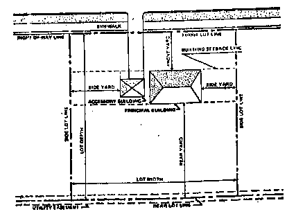
BUILDING SETBACK LINE: An imaginary line established by the zoning ordinance 2 that requires all buildings to be set back a certain distance from lot lines.
BUILDING SITE: An area proposed or improved by grading, filling, excavation or other means for erecting pads for buildings.
CEMETERY: A lot that has been platted for the selling of sites for the burial of animal or human remains.
CITY: The city having jurisdiction of the parcel of land under consideration.
COMMISSION: The Washington County planning and zoning commission 3 , appointed by the city councils of Weiser, Midvale and Cambridge and the Washington County commissioners.
COMMITTEE: That technical committee appointed by the Commission to assist with the technical evaluation of subdivisions and to make recommendations to the Commission. The membership of the committee shall include, but not be limited to, persons that are engaged in either private or public work with specific knowledge in the following areas:
A. Road design and construction.
B. Sewer and water facility design and construction.
C. Health requirements for water and sewer facilities.
D. Environmental planning criteria such as: geology, water systems, vegetation and noise.
E. Solid waste.
F. Recreational and open space.
COMPREHENSIVE PLAN 4 : An adopted document that herein may be referred to as a Comprehensive Plan or Comprehensive Development Plan. The document shall show the general location and extent of present and proposed development, including but not limited to housing, industrial and commercial uses, streets, parks, schools and other community facilities.
CONDOMINIUM: An estate consisting of an undivided interest in common real property, in an interest or interests in real property or in any combination thereof, together with a separate interest in real property, in an interest or interests in real property or in any combination thereof.
COUNCIL: The city councils of the municipal governing bodies.
COVENANT: A written promise or pledge.
CULVERT: A drain that channels water under a bridge, street, road or driveway.
DEDICATION: The setting apart of land or interests in land for use by the public by ordinance, resolution or entry in the official minutes as by the recording of a plat. Dedicated land becomes public land upon the acceptance by the County.
DEVELOPER: Authorized agent of a subdivider or the subdivider himself.
DWELLING UNIT: Any building or other structure proposed or built for occupancy by people.
EASEMENT: A grant by a property owner to specific persons or to the public to use land for specific purposes. Also, a right acquired by prescription.
ENGINEER: Any person who is licensed in the State to practice professional engineering.
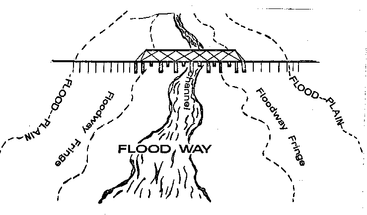
FLOOD PLAIN: The relatively flat area or low land adjoining the channel of a river, stream, lake or other body of water which has been or may be covered by water of a flood of one hundred (100) year frequency. The flood plain includes the channel, floodway and floodway fringe, as established per the engineering practices as specified by the Army Corps of Engineers as follows:
Channel: A natural or artificial watercourse of perceptible extent, with definite bed and banks to confine and conduct continuously or periodically flowing water.
Flood: The temporary inundation of land adjacent to and inundated by overflow from a river, stream, lake or other body of water.
Flood of 100-Year Frequency: A flood magnitude which has a one percent (1%) chance of being equaled or exceeded in any given year.
Floodway: The channel of a watercourse and those portions of the flood plain adjoining the channel which are reasonably required to carry and discharge the flood water of any watercourse.
Floodway Fringe: That part of the flood plain which is beyond the floodway. Such areas will include those portions of the flood plain which will be inundated by a flood of one hundred (100) year frequency but which may be developed when such development will not have a significant effect upon the flood water carrying capacity of the floodway and the flood water levels. Such areas are characterized by shallow flood depths and low velocities of water flow.
GOVERNING BODY: The County Commissioners of the County of Washington.
HIGHWAY: A street designated as a highway by an appropriate State or Federal agency.
HILLSIDE SUBDIVISION: Any subdivision, or portion thereof, having an average slope of five percent (5%) or more.
IMPROVEMENT: Any alteration to the land or other physical constructions associated with subdivision and building site developments.
INTERSTATE HIGHWAY: A major interstate traffic highway designated for the purpose of carrying fast and/or heavy traffic.
LARGE SCALE DEVELOPMENT: A subdivision, the size of which consists of fifty (50) or more lots or dwelling units.
LOT: A parcel, plot, tract or other land area of suitable size as required in these regulations and the existing Zoning Ordinance 5 and created by subdivision for sale, transfer or lease.
LOT AREA: The area of any lot shall be determined exclusive of street, highway, alley, road or other rights of way.
LOT TYPES: Lot types are as follows:
A. Corner lot is a lot located at the intersection of two (2) or more streets.
B. Interior lot is a lot other than a corner lot, with frontage on only one street.
C. Through lot is a lot with frontage on more than one street other than a corner lot.
MOBILE HOME: A detached single-family dwelling unit with all of the following characteristics:
A. Designed for long-term occupancy and containing sleeping accommodations, a flush toilet, a tub or shower bath and kitchen facilities with plumbing and electrical connections provided for attachment to outside systems.
B. Designed to be transported, after fabrication, on its own wheels or on flatbed or other trailers or detached wheels.
C. Arriving at the site where it is to be occupied as a dwelling complete, including major appliances and furniture, and ready for occupancy except for minor and incidental unpacking and assembly operations, location on foundation supports, connection to utilities and the like.
MOBILE HOME SUBDIVISION: A subdivision designed and intended for exclusive mobile home residential use.
MONUMENT: Any permanent marker, either of concrete, galvanized iron pipe or iron or steel rods, used to identify any tract, parcel, lot or street lines, as specified in section 50-1303, Idaho Code, as amended.
OPEN SPACE: An area open to the sky for outdoor recreation activity, exclusive of streets, buildings or other covered structures.
ORIGINAL PARCEL OF LAND: A lot or tract as recorded on any plat or record on file in the office of the recorder, or any unplatted contiguous parcel of land held in one ownership and of record as of April 9, 1979. Individual tax notices or individual deeds do not necessarily constitute an original tract or parcel of land.
OWNERSHIP: The individual, firm, association, syndicate, partnership or corporation having any interest in the land to be subdivided.
PERFORMANCE BOND: An amount of money or other negotiable security paid by the subdivider or his surety to the clerk of the district court which guarantees that the subdivider will perform all actions required by the governing body regarding an approved plat, and provides that if the subdivider defaults and fails to comply with the provisions of an approved plat, the subdivider or his surety will pay damages up to the limit of the bond, or the surety will itself complete the requirements of the approved plat.
PLANNED UNIT DEVELOPMENT SUBDIVISION: A subdivision designed as a combination of residential, commercial and industrial uses planned for a tract of land to be developed as a unit under single ownership or control, which is developed for the purpose of selling individual lots or estates, whether fronting on private or dedicated streets, which may include two (2) or more principal buildings.

PLANNING AND ZONING ADMINISTRATOR: The county planning and zoning administrator; an official, having knowledge in the principles and practices of subdividing 6 .
PLANNING COMMISSION: See the definition of Commission.
PLAT: The drawing, mapping or planning of a subdivision, cemetery, townsite or other tract of land or a replatting of such including certifications, descriptions and approvals.
Final Plat: The final and formal presentation by drawings of an approved subdivision development, the original and one copy of which is filed with the clerk of the district court.
Preliminary Plat: The first formal presentation by drawings of a proposed subdivision.
RECORDER: The office of the county recorder.
RESERVE STRIP: A strip of land between a partial street and adjacent property which is reserved or held in public ownership for future street extension or widening.
RESIDENTIAL SUBDIVISION: Any division or subdivision of real property with a residence or residential use attached to, or associated with, any of the resulting parcels.
RIGHT OF WAY: A parcel of land dedicated or reserved for use as a public way, which normally includes streets, sidewalks, utilities or other service functions.
STANDARD SPECIFICATIONS: The specifications as specified in this title or as officially adopted by the Washington County commissioners.
STATE: The state of Idaho.
STREET: A public right of way that provides access to adjacent properties, the dedication of which has been officially accepted and has been accepted for maintenance by the local road jurisdiction having authority over the right of way. The term "street" also includes the terms "highway", "parkway", "road", "avenue", "boulevard", "lane", "place", and other such terms.
Alley: A public service way used to provide secondary vehicular access to properties otherwise abutting upon a street.
Approach: See definition of Driveway at section 5-2-1 of this code.
Arterial: A general term including expressways, major and minor arterial streets, and interstate, state or local highways having regional continuity.
Minor Arterial: A street and/or roadway designed for relatively uninterrupted traffic movement between cities, towns and other major traffic generators. Typically rural minor arterials include state highways and major county highways. They serve most of the larger communities not served by the principal arterial system and serve other traffic generators capable of attracting travel over long distances. They form an integrated network, provide interstate and intercounty service, provide trip length and travel density greater than those served by the collector systems and provide relatively high travel speeds. Minor arterials also minimize interference to through movement.
Principal Arterial: A street and/or roadway for traffic movement between major population centers without traffic control delays. Typically principal arterials include the interstate system and other major highways. They provide high speed travel, minimal interference to through movement.
Collector: A street that provides for traffic movement between neighborhoods of local highway jurisdiction and between arterial streets and local streets and for limited direct access to abutting property.
Major Collector: A street and/or roadway designed to serve large towns and traffic generators that are not directly served by an arterial. Typically, major collector roads serve as important intracounty (within the county) travel corridors and provide service to any county seat not on an arterial route and to the larger communities not directly served by the higher systems.
Minor Collector: A street and/or roadway designed to provide traffic service to smaller communities and locally important generators. Typically minor collector roads accumulate traffic from the local roads and provide access to the higher type roadway system. They also are spaced at intervals consistent with population density, collect traffic from local roads and tend to feed predominantly local traffic from side streets into major collectors or arterials.
Cul-De-Sac: A short local street having one end permanently terminated in a vehicular turnaround.
Frontage: A minor street, parallel to and adjacent to an arterial street, to provide access to abutting properties.
Local: A street that provides for direct access to residential, commercial, industrial, or other abutting land for local traffic movements and connects to collector and/or arterial streets.
Local streets with low traffic volumes are often subdivided into subclasses. These functional subclasses of local roads are based on the "Guidelines For Geometric Design Of Very Low Volume Local Roads (ADT400)" published by AASHTO and include:
Agricultural Access Roads: A street and/or roadway designed to provide access into adjacent farming or ranching operations, often used by large and slow moving farm equipment.
Industrial/Commercial: A street and/or roadway designed to provide access from higher type roadways into an industrial/commercial area, often used by a large percentage of trucks and other heavy vehicles.
Major Access: A street and/or roadway designed to provide access to abutting property as well as access through an area or between higher type roadways.
Minor Access: A street and/or roadway designed to serve primarily as access to abutting property, often with no through route (dead end roads).
Recreational And Scenic: A street and/or roadway designed to serve special land use areas including campsites, boat ramps and other recreational facilities.
Resource Recovery: A street and/or roadway designed to facilitate the recovery of natural resources including mining and logging operations. These roads typically serve many large vehicles operated by professional drivers.
Loop: A street with both terminal points on the same street of origin.
Partial: A dedicated right of way providing only a portion of the required street width, usually along the edge of a subdivision or tract of land.
Private Road: A street that is not accepted for a public use or maintenance that provides vehicular and pedestrian access to two (2) or more permanent residences and, to a lesser extent, commercial, industrial and other uses.
SUBDIVIDER: The individual, firm, corporation, partnership, association, syndicate, trust or other legal entity that executes the application and initiates proceedings for the subdivision of land in accordance with the provisions of this title. The subdivider need not be the owner of the property; however, he shall be an agent of the owner or have sufficient proprietary rights in the property to represent the owner.
SUBDIVISION: The result of an act of dividing an original lot, tract or parcel of land into more than four (4) parts for the purpose of:
A. Transfer of ownership or development.
B. Dedication of a public street.
C. The addition to or creation of a cemetery.
However, this title shall not apply to any of the following:
A. An adjustment of lot lines as shown on a recorded plat which does not reduce the area, frontage, width, depth or building setback lines of each building site below the minimum zoning requirements and does not change the original number of lots in any block of the recorded plat.
B. An allocation of land in the settlement of an estate of a decedent or a court decree for the distribution of property.
C. The unwilling sale of land as a result of legal condemnation as defined and allowed in the Idaho Code, as amended.
D. Widening of existing streets to conform to the comprehensive plan.
E. The acquisition of street rights of way by a public agency in conformance with the comprehensive plan.
F. The exchange of land which does not result in the change of the present land usage.
G. The sale of land to a public agency.
SURVEYOR: Any person who is licensed in the state as a public land surveyor to do professional surveying.
TECHNICAL REVIEW COMMITTEE: See definition of Committee.
URBAN CONSTRUCTION STANDARDS: The required public improvements that are mandatory on subdivision lot sizes forty thousand (40,000) square feet or less.
VARIANCE: A modification of the strict terms of the relevant regulations where such modification will not be contrary to the public interest and where, owing to conditions peculiar to the property and not the result of the action of the applicant, a literal enforcement of this title would result in unnecessary and undue hardship.
VICINITY MAP: A small scale map showing the location of a tract of land in relation to a larger area. (Ord. 6, 4-9-1979; amd. 1995 Code; Ord. 42, 12-16-1996, eff. 1-1-1997; Ord. 63, 7-13-2009; Ord. 77, 12-29-2014)
Notes
| 1 | 1. See title 1, chapter 5 of this code. |
| 2 | 2. See title 5 of this code. |
| 3 | 1. See title 1, chapter 7 and section 5-18-2 of this code. |
| 4 | 1. See Title 4, Chapter 4 of this Code. |
| 5 | 1. See Title 5 of this Code. |
| 6 | 1. See section 5-18-1 of this code. |