(a) Street Design. The arrangement, character, extent and location of all streets shall be considered in their relation to existing and planned streets, topographical conditions, and public convenience and safety; and in their appropriate relation to the proposed uses of land to be served by such streets.
(1) The pavement design shall meet or exceed the minimum requirement of these Subdivision Regulations:
A. In single-family residential and local streets, minimum requirements may be upgraded because of soil conditions.
B. Non-single family residential street construction will require pavement design based upon usage and soil type.
C. Collector streets, where designated, and commercial streets, where proposed, will require designed pavement based on usage and soil type.
D. In areas of soft subgrade, roadway shall be undercut to stable soil, compacted, and filled with acceptable material, and shall be designated on the plan.
(b) Streets for Residential Subdivisions. The street pattern shall discourage through traffic in the interior of a subdivision, but provisions must be made by the developer for continuance of the street pattern where required by the Commission.
(c) Streets for Commercial Subdivisions. Streets within business developments shall be planned to connect with arterial streets so as not to generate traffic on local streets. Streets from Commercial developments shall intersect arterial or collector streets so as to cause the least possible interference with traffic movement on the streets. The design standard for the typical section shall be approved by the Commission and County Engineer, based on intended use and soil type.
(d) Streets for Industrial Subdivisions. Collector streets for industrial subdivisions shall be designed to serve industrial areas exclusively and shall connect with arterial streets so that no industrial traffic will be directed into any residential neighborhoods. The design standard for the typical section shall be approved by the Commission and the County Engineer.
(e) Service or Marginal Access Streets. A service or marginal access street may be required adjacent to major thoroughfare and non-access right of ways to provide maximum safety and convenience. The design standard for the typical section shall be approved by the Commission and County Engineer, based on intended use and soil type.
(f) Street Extensions. Dedicated streets shall be extended to undeveloped areas in accordance with block requirements to provide maximum safety and convenience for future development. A temporary turnaround or barricade may be required by the Commission.
(g) Temporary Turnaround. A temporary turnaround may be required by the Commission as a part of a continuing street plan.
(1) The turnaround shall have a minimum inside radius of forty feet, paved area and a minimum outside right-of-way of sixty feet.
(2) A "T" turnaround of suitable design may be approved by the Commission.
(3) The Commission may require a larger inside and outside radius and the County Engineer may require upgrading on standard construction depending on intended use and soil type.
(4) It shall be the responsibility of the original developer or the new grantee to remove the temporary turnaround when a street is extended, if the street pattern is part of the valid preliminary plat as approved by the Commission.
(5) Once a subdivision is fully constructed according to approved construction drawings, valid preliminary plan and recorded final plat(s), where a temporary turnaround has been constructed to the acreage being developed, then it is the responsibility of the developer or land owner gaining the benefit of the street extension to properly remove the turnaround and make any street, drainage and sewer improvements required by the Commission and County Engineer.
(h) Street Reservation. Where the frontage along an existing street or road is being platted, the Commission may require a street opening (width to be determined) be reserved for access in order to facilitate future development of the remaining acreage and to avoid landlocking any parcel of land.
(1) The Commission may require a street stub dedication, off an existing street or road right-of-way, in order to help prevent transfer of ownership for any other purpose.
(2) A temporary placement of a barricade may be requested by the Commission. The removal of the barricade will be the responsibility of the abutting property owner gaining benefit of the street reservation, once the Commission has approved a preliminary plat and proper construction drawings are approved by the County Engineer for the acreage being developed.
(i) Half-Streets. Dedication of new half-streets shall be prohibited in order to help protect the health, safety and general welfare of the citizens within the community.
(j) Island. Street islands may be installed by special permission of the Commission.
(k) Major Thoroughfare Plan. The subdivider's engineer or surveyor in designing a street or lot pattern shall conform to the Mahoning County Major Thoroughfare Plan by showing in dash line on the Preliminary and Final plats all proposed right-of-way widths affecting the intended subdivision. The building setback lines shall then be established based on the proposed widening and not on the existing right-of-way width.
(l) Subdivision Name. The subdivision name shall not duplicate or be confused with existing subdivisions, any previously approved development still within the improvement stage or any development plan under consideration by the Commission.
(m) Street Names. Streets shall be named without duplication.
GENERAL DIRECTION | OVER 1000 Ft. | UNDER 1000 Ft. |
North-South | Street | Place |
East-West | Avenue | Court |
Curving | Drive | Lane -Circle |
Diagonal | Road | Way |
See Section 1109.01(j) - Street Signs | ||
(n) Location of Utilities.
(1) Wherever possible, utilities shall be located underground and along rear lot lines or within the street right-of-way.
(2) The utilities shall be located within streets right-of-way as follows:
A. Sanitary Sewer: On centerline of street or behind curb.
B. Storm Sewer: In park strip.
C. Water Line: In park strip opposite side of storm sewer or where feasible.
D. Electric, Telephone: In park strip.
E. Gas: In park strip on same side as water line or as feasible.
(o) Platting of Lots Within Vicinity of High Pressure Fuel Transmission Lines or any Combustible and Flammable Material. The Commission may require the subdivider to request a review from the owner(s) of the transmission line(s) located within or adjacent to the area to be platted before a preliminary or final plat is approved by the Commission in order to help ensure the health, safety and general welfare of the residents within the community.
(1) The location of high pressure fuel transmission lines or any combustible and flammable material shall be properly shown on all preliminary and final plats, along with pipeline locations, size, depths, easement width along with volume and page of recording. The pressure of the lines should be shown where possible.
NOTE:The Commission may require additional depth, width or overall lot area where a new parcel of real estate abuts the transmission lines.
(p) Horizontal Curves. Where is an angle of deflection of more than ten degrees between two centerline tangent sections of a street, a curve of adequate radius shall connect, (see subsections (t) to (u)). Between reverse curves, a minimum tangent of 100 feet shall be required.
HORIZONTAL ALIGNMENT EXAMPLE
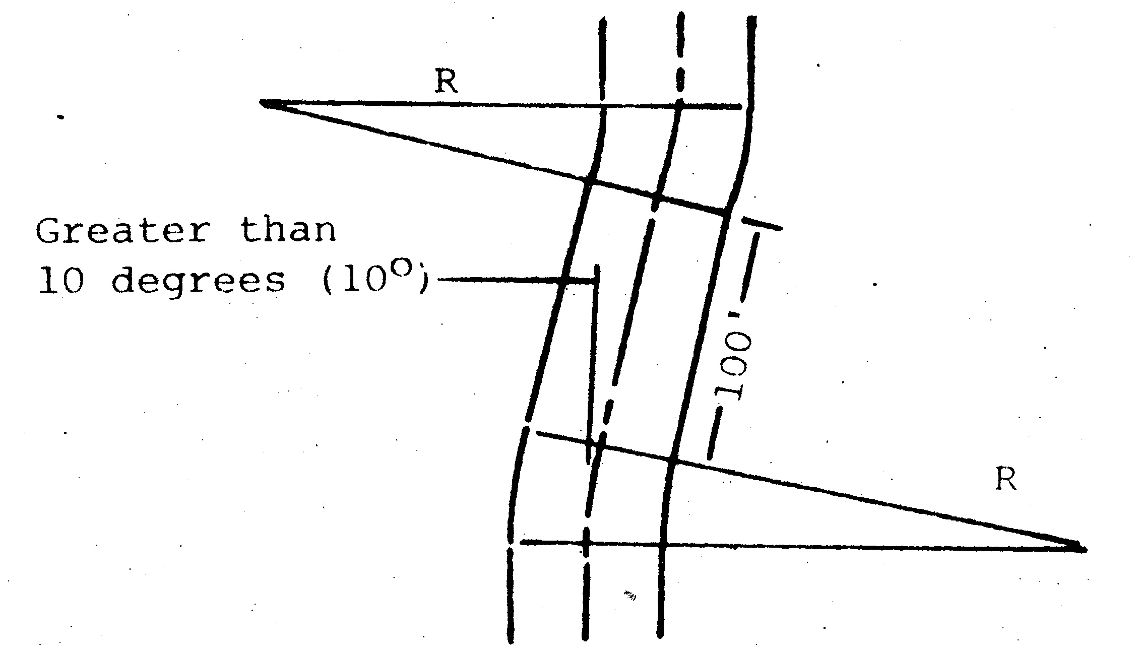 |
(q) Vertical Alignment. Vertical curves of a minimum length of 100 feet shall be required where the difference in grade is two percent (2%) or more. In all cases the vertical curve design shall be subject to the approval of the County Engineer.
(1) No street shall be less than six tenths of one percent (0.6%) in grade.
(2) In no case shall a street grade be more than two percent (2%) within 100 feet of an intersection.
(r) Intersection Sight Distance. Intersection sight distance is defined as the sight distance needed along the main roadway for a car entering from a crossroad to make a left turn onto the main roadway while clearing traffic approaching from the left. For good design the actual measured intersection sight distance should be greater than what is listed in the following table.
INTERSECTION SIGHT DISTANCE
Design Speed (MPH) | Minimum Intersection Sight Distance (FT.) |
70 | 950 |
65 | 875 |
60 | 825 |
55 | 750 |
50 | 700 |
45 | 625 |
40 | 575 |
35 | 500 |
30 | 450 |
25 | 375 |
20 | 300 |
(1) The design speed is that of the main roadway.
(2) All of the above information was compiled from The Ohio Department of Transportation, Location and Design Manual, Revised March, 1987.
(3) All other references to sight distance or stopping sight distance in these regulations shall be revised to intersection sight distance.
(s) Design Standards for a Local Street.
(1) Right-of-way (ft.) | See Typical Section |
(2) Pavement Width (ft.) | See Typical Section |
(3) Sidewalk (ft.) | 4 |
(4) Minimum Stopping Distance | See subsection (r) |
(5) Maximum Grade | 8% |
(6) Minimum Grade | 0.6% |
(7) Maximum Cul-de-Sac Length (ft.) | 500 |
(8) Minimum Cul-de-Sac Right-of-Way Radius (ft.) | 60 |
(9) Minimum Cul-de-Sac Pavement Radius (ft.) | 40 |
(10) "T" Turnaround | See Typical Section |
(11) Minimum Centerline Radius (ft.) | 100 |
(t) Design Standards for a Collector Street (Residential, Commercial, Industrial).
(1) Right-of-way (ft.) | See Typical Section |
(2) Pavement Width (ft.) | See Typical Section |
(3) Sidewalk (ft.) | 5 |
(4) Minimum Stopping Distance | See subsection (r) |
(5) Maximum Grade | 8% |
(6) Minimum Grade | 0.6% |
1320 | |
(8) Minimum Centerline Radius (ft.) | 350 |
(9) Cul-de-Sac design involving a collector street is rare, but if required the design must be approved by the Commission based on intended use and soil type. | |
NOTE: For storm sewer, roadside ditch and culvert design, see Sections 1109.04 (b)(3), (4), (5) and (c)(1).
(u) Intersection Design Standards.
(1) Minimum angle of intersection streets shall remain in the angle of intersection for at least 100 feet beyond the point of intersection.
(2) Ninety degree angle required, unless otherwise approved by the Commission.
(3) The intersection of the right-of-way lines at all street intersections shall be rounded by a minimum radius equal to one-half of the larger right-of-way width of the intersecting streets.
(4) Minimum centerline offset (Jog) of adjacent intersection (ft.)
A. Local-Local | 150 |
B. Local-Collector | 200 |
C. Collector-Collector | 300 |
D. Collector, Service-Arterial | 1320 |
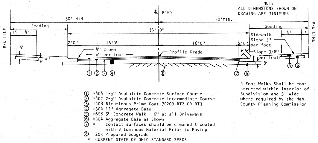
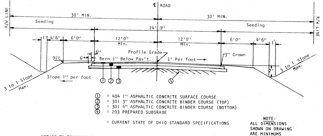
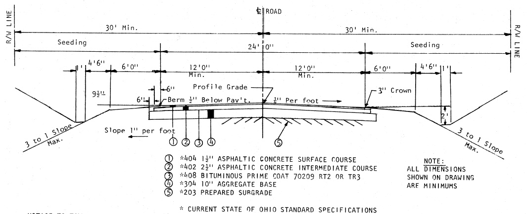
TYPICAL SECTIONS FOR STREETS
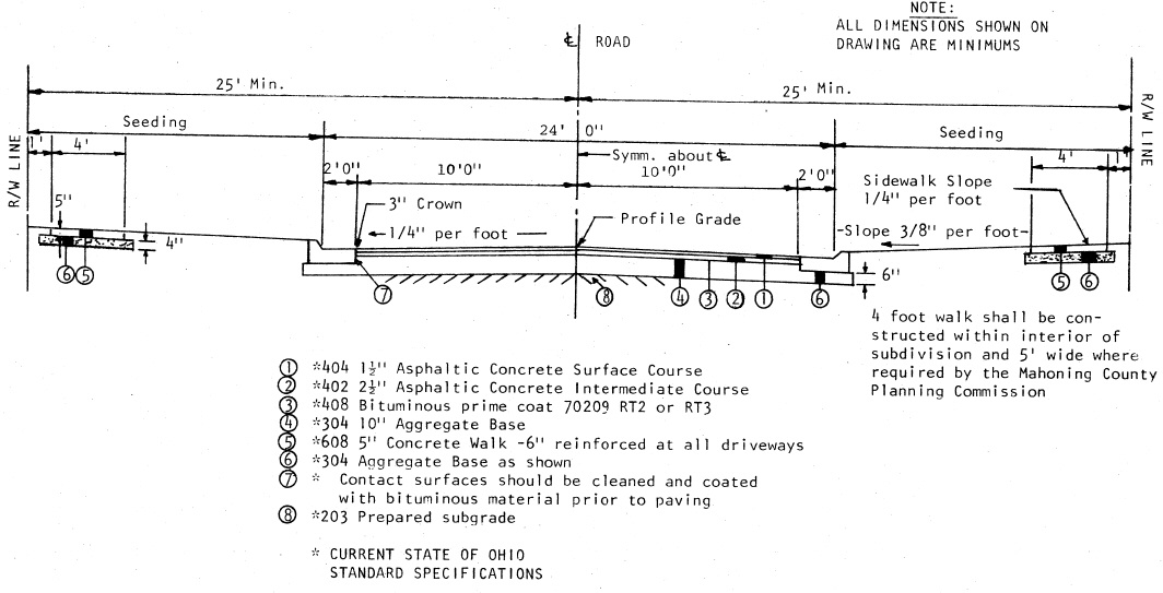
l. Local Residential - | Type A - Full Depth Asphalt |
2. Local Residential - | Type A - With Aggregate |
3. Local Residential - | Type A - Concrete Pavement |
4. Collector - | Type A - Full Depth Asphalt |
5. Collector - | Type A - With Aggregate |
6. Collector - | Type A - Concrete Pavement |
7. Local Residential - | Type B - Full Depth Asphalt |
8. Local Residential - | Type B - With Aggregate |
9. Local Residential - | Type B - Concrete Pavement |
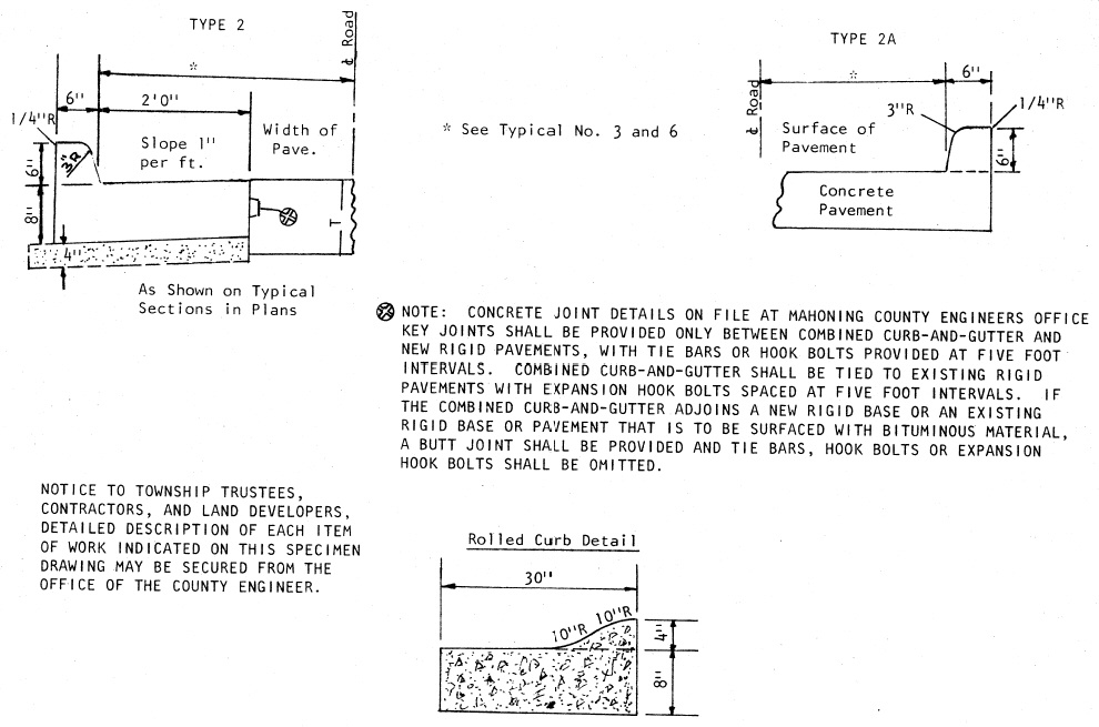
10. Local Residential - | Type 2, 2A and Roll Curb Sections |
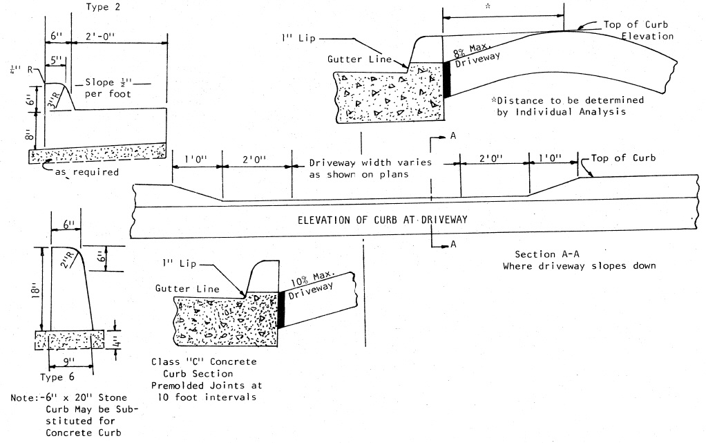
11. Local Residential - | Type 2 and Type 6 - Driveway Curb Sections |
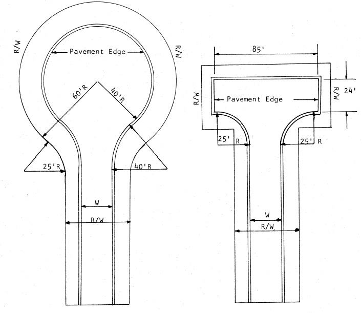
12. Local Residential - | Typical Turnarounds |
For Commercial and Industrial streets, the improvement standards shall be approved by the Commission and the County Engineer depending on intended use and soil type.
1.
TYPICAL SECTION TYPE A (FULL DEPTH ASPHALT)
MAHONING COUNTY
RESIDENTIAL (LOCAL)
NOTICE TO TOWNSHIP TRUSTEES, CONTRACTORS, AND LAND DEVELOPERS:
DETAILED DESCRIPTION OF THE EACH ITEM INDICATED ON THIS SPECIMEN DRAWING MAY BE SECURED FROM THE OFFICE OF THE COUNTY ENGINEER.
2.
TYPICAL SECTION TYPE A (WITH AGGREGATE)
MAHONING COUNTY
RESIDENTIAL (LOCAL)
 |
NOTICE TO TOWNSHIP TRUSTEES, CONTRACTORS, AND LAND DEVELOPERS:
DETAILED DESCRIPTION OF THE EACH ITEM INDICATED ON THIS SPECIMEN DRAWING MAY BE SECURED FROM THE OFFICE OF THE COUNTY ENGINEER.
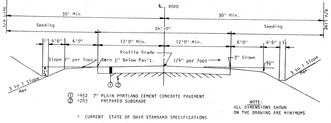
3.
TYPICAL SECTION TYPE A (7" CONCRETE PAVEMENT)
MAHONING COUNTY
RESIDENTIAL (LOCAL)
NOTE: ALL DIMENSIONS SHOWN ON DRAWING ARE MINIMUMS
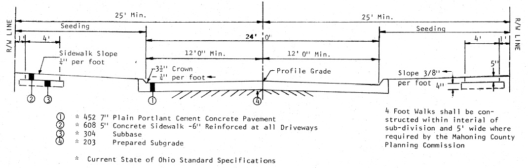 |
NOTICE TO TOWNSHIP TRUSTEES, CONTRACTORS, AND LAND DEVELOPERS:
DETAILED DESCRIPTION OF THE EACH ITEM OF WORK INDICATED ON THIS SPECIMEN DRAWING MAY BE SECURED FROM THE OFFICE OF THE COUNTY ENGINEER.
4.
FULL DEPTH ASHPALT TYPICAL SECTION(TYPE A)
MAHONING COUNTY
COLLECTOR
NOTE: ALL DIMENSIONS SHOWN ON DRAWING ARE MINIMUMS
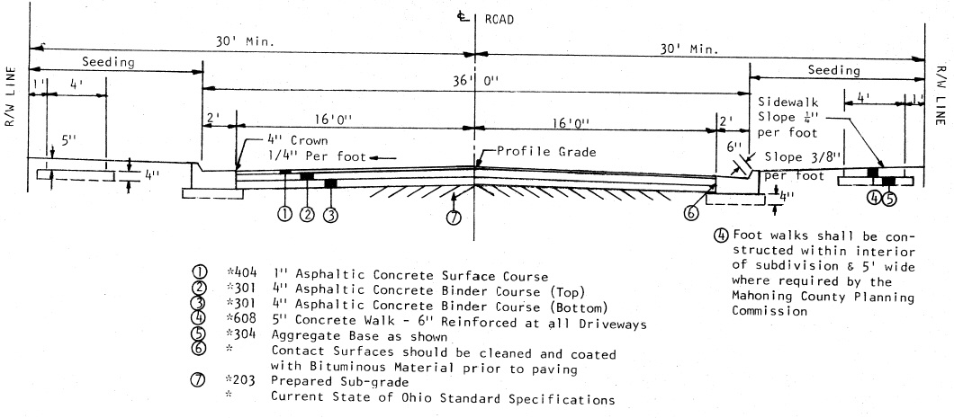 |
NOTICE TO TOWNSHIP TRUSTEES, CONTRACTORS, AND LAND DEVELOPERS:
DETAILED DESCRIPTION OF THE EACH ITEM INDICATED ON THIS SPECIMEN DRAWING MAY BE SECURED FROM THE OFFICE OF THE COUNTY ENGINEER.
5.
TYPICAL SECTION TYPE A (WITH AGGREGATE)
MAHONING COUNTY
COLLECTOR
 |
NOTICE TO TOWNSHIP TRUSTEES, CONTRACTORS, AND LAND DEVELOPERS:
DETAILED DESCRIPTION OF THE EACH ITEM INDICATED ON THIS SPECIMEN DRAWING MAY BE SECURED FROM THE OFFICE OF THE COUNTY ENGINEER.
6.
TYPICAL SECTION TYPE A (8" CONCRETE PAVEMENT)
MAHONING COUNTY
COLLECTOR
 |
NOTICE TO TOWNSHIP TRUSTEES, CONTRACTORS, AND LAND DEVELOPERS:
DETAILED DESCRIPTION OF THE EACH ITEM OF WORK INDICATED ON THIS SPECIMEN DRAWING MAY BE SECURED FROM THE OFFICE OF THE COUNTY ENGINEER.
7.
TYPICAL SECTION TYPE-B (FULL DEPTH ASPHALT)
MAHONING COUNTY
LOCAL (RESIDENTIAL)
 |
NOTICE TO TOWNSHIP TRUSTEES, CONTRACTORS, AND LAND DEVELOPERS:
DETAILED DESCRIPTION OF THE EACH ITEM OF WORK INDICATED ON THIS SPECIMEN DRAWING MAY BE SECURED FROM THE OFFICE OF THE COUNTY ENGINEER.
8.
TYPICAL SECTION T YPE-B (WITH AGGREGATE BASE)
MAHONING COUNTY
LOCAL (RESIDENTIAL)
 |
NOTICE TO TOWNSHIP TRUSTEES, CONTRACTORS, AND LAND DEVELOPERS:
DETAILED DESCRIPTION OF THE EACH ITEM OF WORK INDICATED ON THIS SPECIMEN DRAWING MAY BE SECURED FROM THE OFFICE OF THE COUNTY ENGINEER.
9.
RESIDENTIAL (LOCAL)
TYPICAL SECTION TYPE-B (7" CONCRETE PAVEMENT)
MAHONING COUNTY
 |
NOTICE TO TOWNSHIP TRUSTEES, CONTRACTORS, AND LAND DEVELOPERS:
DETAILED DESCRIPTION OF THE EACH ITEM OF WORK INDICATED ON THIS SPECIMEN DRAWING MAY BE SECURED FROM THE OFFICE OF THE COUNTY ENGINEER.
10.
TYPICAL CURB SECTION (TYPE 2 AND 2A)
MAHONING COUNTY
RESIDENTIAL (LOCAL)
 |
11.
TYPICAL DRIVEWAY CURB SECTION (TYPE 2 AND TYPE 6)
MAHONING COUNTY
RESIDENTIAL (LOCAL)
 |
12.
TYPICAL TURNAROUNDS
MAHONING COUNTY
RESIDENTIAL (LOCAL)
 |
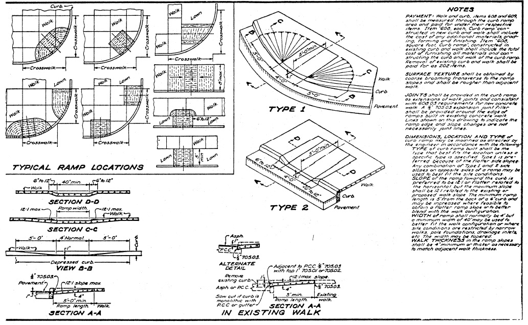
CURB RAMPS
 |