1. Special precautions must be made with regards to erosion/sedimentation control and stormwater management which are related to subdivision and land development and construction activities. This Section outlines reasonable standards for erosion and sedimentation control and stormwater management in order to:
A. Promote the general health, welfare and safety of residents in the Borough;
B. Regulate the modification of the natural terrain and alteration of existing drainage from new subdivision and land developments in order to control erosion and sedimentation from soils, minimize the effect of pollution, and preserve stream channels;
C. Provide design, construction and maintenance criteria for permanent on-site stormwater management facilities for the purpose of controlling stormwater, erosion and sedimentation pollution;
D. Encourage recharge of groundwater and the preservation and restoration of the flood carrying capacity of streams; and
E. Provide for the proper installation and maintenance of stormwater management facilities. This part does not imply that areas within or outside any identified flood-prone areas shall be free from flooding or flood damage.
2. Erosion and Sedimentation Control Plan.
A. General Requirements and Standards.
(1) In conjunction with the submission of a subdivision or land development plan and for any activities involving earth disturbance of more than 5,000 square feet, an erosion and sedimentation control (E&S) plan must be submitted to the County Conservation District for their approval in accordance with the requirements of the “Rules and Regulations”, Chapter 102, EROSION CONTROL authorized under P. L. 1987, June 22, 1987. A copy of the E&S Plan must be provided to the Borough. Subsequently, an approved erosion and sedimentation control plan, together with a letter from the Perry County Conservation District indicating whether a National Pollutant Discharge Elimination System (NPDES) Permit from the Department of Environmental Protection for earthmoving activity is required, must be provided to the Borough.
(2) The applicant shall be responsible to prepare and forward all applicable erosion and sedimentation control plan information and other data to the appropriate county and state agencies.
(3) The Borough shall not issue a zoning or building permit to those engaged in earth moving activities requiring a Department of Environmental Protection permit or other NPDES Permits, until the Department has reviewed and issued any applicable permit.
(4) Maintenance of erosion and sediment control measures is required by the applicant/developer. The Perry County Conservation District and the Borough, as authorized by the Municipalities Planning Code, reserve the right to inspect these measures at any time before the building occupancy permit is issued and may issue a notice of violation if the installed measures are found to be in significant non-compliance. Said notice will list the specific type, location and scope of each violation, and a period of time during which the person(s) responsible for the earth-moving activity must correct the violations. Failure to comply with the notice or multiple violations may result in a cease and desist order issued by the Borough to prevent or restrain building, construction or conduct of business, and to correct or abate accelerated erosion and sediment pollution to waters of the Commonwealth.
(5) Earth disturbance activities other than those necessary for preparation of sites for building foundations, stormwater and sediment control devices and on-site sewage disposal systems, shall be minimized between October 15 and February 15.
(6) In the preparation of erosion and sedimentation control plans the person preparing such plans shall consult with the Perry County Conservation District to determine the measures needed to control erosion and sedimentation pollution. The Erosion and Sediment Pollution Control Program Manual, prepared by the Pennsylvania Department of Environmental Protection in accordance with Chapter 102 shall be used in the preparation of such plans. Copies are available in the Perry County Conservation District office.
3. Stormwater Management Plan.
A. A stormwater management plan shall be submitted when any person, partnership, business or corporation shall undertake a subdivision or land development that involves any of the following activities and in no case will these activities be undertaken without written approval from the Borough:
(1) Earth disturbing activity involving 5,000 square feet or more, except agricultural activity, provided such activity conforms to USDA Natural Resource Conservation Service guidelines;
(2) Diversion or piping of any natural or manmade stream channel;
(3) Installation of stormwater systems or appurtenances thereto;
(4) Movement or alteration to an existing stormwater management system, included but not limited to, pipes, swales, basins, infiltration trenches, etc;
(5) Placement of fill, structures or pipes in the floodplain as designated on the official floodplain map, and as may be documented by other pertinent sources of floodplain information used by the Borough;
(6) Installation of impervious cover totaling 5,000 square feet or more on a single lot, or 2 or more lots when proposed as part of an overall plan.
(7) In accordance with Part 3 (§22-305), Modifications of Requirements, the Borough may waive the requirements of this Section in favor of the following: Whenever any activity set forth in this Section is determined by the Borough Engineer not to require retention or detention of stormwater runoff and direct discharge of stormwater runoff is approved by the Borough Council, the owner/developer shall be required to determine the impact of said direct discharge on all downstream drainage facilities and property as identified by the Borough Engineer and shall submit, with the Preliminary and Final Plans, a report of the study of the impacts on downstream facilities and property.
B. Content of the Stormwater Management Plan. The stormwater management plan shall be submitted in mapped tabular and digital form in accordance with the standards contained in Exhibits 5-1 through 5-4 and shall identify all proposed stormwater management facilities and supportive information outlined in this Section. Stormwater management data shall be prepared by a professional engineer or landscape architect registered in the Commonwealth of Pennsylvania to perform such duties. A certificate of accuracy must accompany stormwater management plans, and a signature and seal of the engineer or landscape architect responsible must appear on the plan. For subdivision or land development activities, the stormwater management plan shall be included as part of the subdivision or land development plan submission(s) to the Borough and shall include the following items:
(1) A general statement describing the project, the date the project is expected to begin and end, a description of existing and proposed conditions; ownership and maintenance of facilities, and conclusions. Conclusions shall include a comparison of existing and proposed peak rates of runoff at all points where runoff leaves the applicant’s property;
(2) A 7 ½ minute USGS topographic map, or equivalent, illustrating the project location and its total watershed(s), and additional maps as necessary, to clearly indicate the delineation of all drainage areas, both on site and off site, used in all computations for all drainage and stormwater management facilities;
(3) Existing and finished contours, 2-foot intervals, except in areas where slope is greater than 20%, in which case the contour interval shall be 5 feet;
(4) Aerial extent of the project soils from Perry/Cumberland Soil Survey with annotations for erodible soils, hydric soils, and soils with hydric inclusions;
(5) Boundary lines of the project area;
(6) Existing drainage on project and adjoining properties such as floodplain, wetlands, streams, lakes, ponds and easements;
(7) All calculations, assumptions, criteria, and references used in the design of the stormwater management facilities, the establishment of existing facilities capacities, and the pre- and post-development discharges;
(8) All plans and profiles of the proposed stormwater management facilities, including horizontal and vertical location, size and type of material;
(9) For all basins, a plotting or tabulation of the storage volumes and discharge curves with corresponding water surface elevations, inflow hydrographs, and outflow hydrographs, including all assumptions and calculation methodologies;
(10) The guidelines for lot grading within the subdivision. This information shall identify the direction of stormwater runoff flow within each lot and the areas where stormwater runoff flows will be concentrated. This information shall be shown by topographical data including contours and spot elevations. Plans which assume future transfer of lot ownership shall show individual lot grading which maintains the proposed stormwater management plan, or a phasing plan shall be submitted with separate calculations which address interim stormwater management.
(11) When stormwater management plans are for a portion of a larger project or include offsite flows through the subject property, a generalized stormwater management plan for the entire project shall be included in the plan. This generalized plan shall demonstrate how the stormwater for the proposed section will relate to the entire development. If temporary facilities are required for construction of a section, such facilities shall be included in the submitted plans. In the event temporary measures cannot adequately handle the stormwater runoff, the main outfall shall be included as part of the construction of the proposed sections and detailed information regarding these facilities shall be included with the plan.
C. General Design Guidelines for Stormwater Management Facilities. The following design guidelines are presented as the minimum acceptable standards available at the time this Chapter was adopted. New and innovative procedures are encouraged and shall be permitted on a case by case basis as approved by the Borough Engineer. Future stormwater ordinances, whether stand-alone or amended to the SALDO, shall be consistent with the applicable county, state and/or federal watershed management plan(s).
(1) In the interest of:
(a) Reducing the total area of impervious surface;
(b) Preserving existing features which are critical to stormwater management; and
(c) Reducing the concentration of stormwater flow, the designer should consider the best utilization of land for the least disturbance of natural features, resources and terrain.
(2) Existing on-site natural and manmade stormwater management facilities shall be utilized when and where possible.
(3) Stormwater shall not be transferred from one watershed to another, unless:
(a) The watersheds are sub-watersheds of a common watershed which join together within the perimeter of the property;
(b) The effect of the transfer does not alter the peak discharge onto adjacent lands; or
(c) Easements from the affected landowner are provided.
(4) Consideration shall be given to the relationship of the subject property to the drainage pattern of the watershed. A concentrated discharge of stormwater to an adjacent property shall be within an existing watercourse or enclosed in an easement or returned to a pre-development condition.
(5) Innovative stormwater best management practices (BMPs) and recharge facilities may be proposed (e.g., rooftop storage, drywells, cisterns, recreation area ponding, diversion structures, porous pavements, holding tanks, infiltration systems, stream channel storage, in-line storage in storm sewers, and grading patterns). They shall be located, designed, and constructed in accordance with the latest technical guidance published by the Pennsylvania Department of Environmental Protection provided they are accompanied by detailed engineering plans and performance capabilities and supporting site specific soils, geology, runoff and groundwater and infiltration rate data to verify proposed designs. Additional guidance from other sources may be accepted at the discretion of the Borough Engineer. A pre-application meeting with the Borough Engineer is required.
(6) Infiltration/groundwater recharge stormwater management facilities shall be located, designed, and constructed in accordance with the Pennsylvania Department of Environmental Protection’s NPDES Permit, Post Construction Stormwater Management (PCSM) guidelines for stormwater discharges associated with construction activities, and standards and specifications for infiltration practices.
(7) Infiltration Guidelines and Criteria.
(a) Land development in which impervious cover of natural ground is increased shall provide facilities to minimize the total increase in stormwater runoff to that which would have occurred from the land prior to development. A Post-Construction Stormwater Management Plan (PCSM) shall be designed to control stormwater resulting from the 2-year - 24-hour frequency storm through activities that retain site soil permeability, maintain or restore the site’s vegetative cover, maintain or replicate the original contours, and do not result in direct stormwater discharges to surface waters and allow sites to maintain their natural ability to control runoff volume and velocity, infiltrate stormwater, filter sediments and pollutants, and recycle nutrients.
(b) Stormwater Best Management Practice (BMP) Facilities which provide for percolation and/or storage of water, including: cisterns, French drains, seepage pits, and seepage terraces shall be provided to limit site runoff increases in those areas where soils and water table conditions permit, as determined by soils analysis.
(c) On wooded lots, future runoff increases shall be limited through notes or graphics on approved land development plans prescribing “minimum disturbance/minimum maintenance” areas where special care is taken to preserve existing site vegetation through careful control of the envelope of disturbance during proposed new construction.
(d) Vegetated berms or other approved runoff trapping devices such as cisterns may be used in lieu of or in conjunction with infiltration facilities where site conditions limit the use of infiltration techniques.
(e) Measures may be imposed to protect against ground or surface water pollution where the type of business or the nature of the soils underlying a runoff structure would constitute a substantial risk of contamination. These measures shall be outlined in a pollution prevention contingency (PPC) plan prepared under the NPDES permit requirements for post-construction stormwater management (PCSM) plan.
D. Drainage Design and Construction Standards.
(1) Peak Flow.
(a) Stormwater management facilities shall be designed so that the peak discharge of calculated post-development runoff to an adjacent property does not exceed the peak discharge of the calculated pre-development runoff for the required storm frequencies at any point on the perimeter of the land being develop. The design plan and construction schedule must incorporate measures to minimize soil erosion and sedimentation pollution. Because it is not economically sound to provide facilities that can manage the greatest storm on record unless danger to life may be involved, property may be destroyed, or traffic flow on main highways may be interrupted, the runoff calculations for the post-development and pre-development comparison shall use 2.33, 5, 10, 25, 50 and 100-year frequency storm events unless, as stated above, danger to life, property, or traffic may be involved.
(b) In these cases, the Borough may require the comparison, design, and storage of a greater storm event and/or the comparison of a greater post development storm event with a smaller pre-development storm event. In all cases undeveloped land within the project shall be considered good sod surface or natural forest, whichever best describes the pre-development condition.
(c) Runoff coefficient for post development condition shall be based on the land uses listed in Exhibit 5-1.
(d) In cases where impervious cover exists, the Borough Engineer, at the request of the Planning Commission or Borough Council, will determine the characteristics of the pre-developed site for appraising stormwater management requirements.
(2) System Design.
(a) The design of stormwater management facilities (i.e. grass waterways, open channels, swales, ditches, etc.) and all other water carrying facilities shall be based upon a post 10-year frequency storm event.
(b) The design of pipes and inlets and their appurtenances shall be based on a post 25-year storm event.
(c) Stormwater management facilities that convey off-site stormwater through the site shall be designed to convey a post development 100-year frequency storm event.
(d) Stormwater management designs must include provisions that allow for the overload conveyance of the post development 100-year frequency storm event to flow through the site without damage to any public or private property.
(3) Rain Fall.
(a) Runoff calculations for the purposes of developing hydrographs shall be based on the Natural Resources Conservation Service (NRCS) Soil-Cover-Complex Method. The Rational Formula of Q=CIA shall be used for all conveyance calculations.
(b) When the Soil-Cover-Complex Method is used, stormwater runoff calculations shall be based on the NOAA Atlas 14.
(c) When the Rational Method is used, appropriate values of rainfall intensity shall be from the latest edition of the Commonwealth of Pennsylvania, Department of Transportation Design Manual, Part 2, Highway Design, and Chapter 10 (Exhibit 5-2)
(4) Time of Concentration. Times of concentration shall be based on NRCS Segmental Methodology utilizing the following design parameters:
(a) Overland Flow. The maximum length for each reach of overland flow before concentrated swale flow develops is 300 feet, 100 feet for sheet flow and 200 feet for shallow concentrated flow. The appropriate value of Manning’s “n” factor for the given conditions shall be used for determining the times of concentration.
(b) Concentrated Flows. At points where overland flows concentrate in field depressions, swales, gutters, curbs, or pipe collection systems, the time of concentration between these design points shall be based on the Manning Equation and/or acceptable engineering design standards as approved by the Borough Engineer.
(5) Any proposed direct stormwater discharge at the perimeter of the site shall not be beyond the capacity of any existing, immediately contiguous, stormwater management facility into which the discharge flows, regardless of pre-existing conditions.
(6) Natural drainage ways shall be utilized to the maximum extent possible in carrying stormwater runoff, provided such use remains consistent with the purpose of this Part.
(7) Detention and Retention Basins.
(a) Basins shall be designed to safely pass the peak discharge of a post-development 100-year frequency storm event through an emergency spillway with 1 foot of freeboard between the maximum pool elevation and the top of the facility assuming that the outlet structure is 100% clogged. The spillway shall be no more than 50-feet wide and shall be located in undisturbed material and clearly located on the plan. All outlets shall be combined in a manner which will not damage the integrity of the basin or the downstream drainage area.
(b) Retention basins and/or detention basins, and water carrying facilities shall be stabilized promptly in accordance with current soil conservation service practices.
(c) Retention basins and/or detention basins shall be designed and maintained to insure the design capacity after sedimentation has taken place.
(d) Basins which are not designed to release all stormwater shall be specifically identified as retention basins or permanent pond basins. Such basins should not be mown, but rather encouraged to generate ecosystems to maximize recharge, including infrequent planting of native species.
(e) All other basins shall have provisions for de-watering, including the bottom of the basin, and shall not create swampy conditions which are difficult to maintain. Low flow channels and tile fields may be used to de-water the bottom of a basin.
(f) Retention basins and/or detention basins which are designed with earth fill dams shall incorporate the following minimum standards:
(i) The maximum water depth shall not exceed 6 feet in depth unless otherwise approved by the Borough Council after consultation with the Borough Engineer.
(ii) The minimum top width of a dam breast shall be 5 feet unless otherwise approved by the Borough Council after consultation with the Borough Engineer.
(iii) The height of the dam shall not exceed 8 feet from the inside toe of slope, unless otherwise approved by the Borough Council after consultation with the Borough Engineer.
(iv) The side slopes of the compacted earth fill shall not be steeper than 3 horizontal to 1 vertical (3:1).
(v) Basins without restricted access shall have impoundment areas with side slopes no steeper than 5 horizontal to 1 vertical. Basins with steeper side slopes shall be protected by fencing that will restrict access, but will include access gate(s) for maintenance. Fencing at an adequate height to protect the public from entering any retention or detention basin shall be provided.
(vi) A cutoff trench of impervious material shall be provided under all dams, with side slopes of 3 horizontal to 1 vertical or flatter. A dam with steeper sides shall be provided with a key trench.
(vii) All pipes and culverts through dams shall be fitted with watertight joints and shall have properly spaced concrete cutoff collars or factory welded anti-seep collars.
(viii) Minimum floor elevations for all structures that would be affected by a basin, other temporary impoundments, or open conveyance systems where ponding may occur shall be 2 feet above the 100-year stormwater surface, if basement or underground facilities are proposed, detailed calculations addressing the effects of stormwater ponding on the structure and water-proofing and/or flood-proofing design information shall be submitted for approval.
(ix) Trash racks are to be placed on detention basin structures and/or pipe inlets/outlets
(8) Piping.
(a) The capacities of pipes shall be calculated by the Manning Equation or any other method of equal caliber which is acceptable to the Borough Engineer.
(b) Curved pipes, tee joints, elbows, and wyes are prohibited except for pipes with at least a 36-inch diameter or height. Minor horizontal deviations for smaller pipe shall be reviewed on a case by case basis.
(c) All piping used in the storm drainage system shall be in accordance with PennDOT 408 specifications. A minimum pipe size of 18 inches in diameter shall be used in all street systems (public or private) proposed for construction in the Borough. A minimum pipe size of 15 inches in diameter for on-site surface drainage requirements is permitted on private facilities which receive no off-site drainage. Pipes shall be designed so as to provide a minimum velocity of 2 ½ feet per second when flowing full. Arch pipe of equivalent cross-section area may be used in lieu of round pipe where cover or utility conflict conditions exist.
(d) All storm drainage piping discharging to the ground surface shall be provided with either reinforced concrete headwalls and end sections or plastic and metal pipe end sections compatible with the pipe size involved in accordance with PADOT 408 and RC standards. A stabilized apron of adequate length shall be provided at all surface discharge points in order to minimize erosion. The apron shall extend to the crown of the pipe.
(e) The following chart shall be used to determine the “n” factors for corrugated pipe:
“n” Factors | ||||
Pips Diameter (Inches) | Helical | Annular
| ||
Capacity | Velocity | Capacity | Velocity | |
15 and 18 | .017 | .014 | .026 | .024 |
21 through 30 | .021 | .017 | .026 | .021 |
larger than 30 | .026 | .019 | .026 | .019 |
(f) The “n” factor for concrete or any other smooth pipe shall be .010 for velocity and .013 for capacity.
(9) Swales and Channels. The capacities of swales and roadside gutters shall consider all possible hydraulic conditions. Swales shall meet the following requirements:
(a) For grass swales and roadside gutters, two design considerations shall be met:
(i) The channel velocity and stability of the swale or gutter shall be based upon a low degree of retardance (“n” of 0.03);
(ii) The channel capacity shall be based on a high degree of retardance (0.050).
(b) The “n” factor to be used for paved or rip-rap swales or gutters shall be in accordance with the Erosion and Sediment Pollution Control Program Manual, prepared by the Pennsylvania Department of Environmental Protection.
(c) Grass lined or planted channels shall have a minimum slope of 0.7%.
(10) Inlets and Culverts.
(a) Inlets and culverts shall be constructed in accordance with specifications set forth in the PA DOT, Publication 408, and as detailed in the Roadway Construction Standard Drawings contained in PennDOT Standards for Roadway Construction (RC-34) or other detail approved by the Borough Engineer.
(b) All inlets shall have weep holes covered with geotextile fabric placed at the appropriate elevations to completely drain the subgrade prior to placing the base course and surface course.
(c) The maximum allowable spread of water on streets in a 25-year storm event is ½ of a travel lane.
(d) Stormwater management calculations shall include an inlet capacity analysis in order to verify spacing and to compute by-pass flow.
(e) All inlets in paved areas shall have heavy duty bicycle safe grating. A note to this effect shall be added to the subdivision and land development plan.
(f) All pipes entering or exiting inlets shall be cut flush with the inlet wall.
(g) Inlets deeper than 5 feet shall be provided with manhole type steps for access. A note to this effect shall be added to the subdivision and land development plan.
(h) At the bottom of any inlet, additional concrete shall be added and adequately formed to provide for a smooth and efficient flow of water within the inlet. (Refer to PennDOT Standards for Roadway Construction RC-34).
(11) Manholes.
(a) Manholes, when proposed, shall be spaced not more than 400 feet apart. Additionally, manholes shall be placed at points of abrupt changes in the horizontal or vertical direction of storm sewers. Inlets may be substituted for manholes where they will serve a useful purpose.
(b) Manholes shall be constructed in accordance with specifications set forth in the PennDOT, Publication 408, and as detailed in the Roadway Construction Standard Drawings (RC-34).
(12) Runoff Velocity.
(a) The maximum velocity of stormwater runoff shall be maintained at levels which result in a stable channel both during and after channel construction. The following are characteristics of a stable channel:
(i) It neither aggrades nor degrades beyond tolerable limits;
(ii) The channel banks do not erode to the extent that the channel cross-section is changed appreciably;
(iii) Excessive sediment bars do not develop;
(iv) Excessive erosion does not occur around culverts and bridges or elsewhere;
(v) Gullies do not form or enlarge due to the entry of uncontrolled stormwater runoff.
(vi) Where channel or swale bends occur, the computed velocities shall be multiplied by the following factor for the purpose of designing channel erosion protection:
1.5 When swale bend is 0 to 30 degrees;
1.75 When swale bend is 30 to 60 degrees;
2.00 When swale bend is 60 to 90 degrees;
2.50 When swale bend is 90 degrees or greater
(vii) Where the velocity of stormwater runoff exceeds the allowable velocity for soils, erosion protection must be provided. The methods of erosion protection proposed must be supported by the appropriate design information and references.
(b) Grass lined or planted channels shall be considered stable if the calculated velocity does not exceed the allowable velocities shown below:
(i) Three feet per second where only sparse vegetation can be established and maintained because of shade or soil conditions, and for all roadside swales.
(ii) Four feet per second where normal growing conditions exist and vegetation is to be established by seeding.
(iii) Five feet per second where a dense, vigorous sod can be quickly established or where water can be temporarily diverted during establishment of vegetation. Netting and mulch or other equivalent methods for establishing vegetation shall be used.
(iv) Six feet per second where there exists a well established sod or vegetation of good quality. These calculated grass lined or planted channel flows may be exceeded if the designer can provide supportive design criteria as proof of erosion prevention.
(v) Calculated grass lined or planted channel flows may be exceeded if the designer can provide acceptable supportive design criteria as proof of erosion prevention. Where the velocity of stormwater runoff exceeds the allowable velocity, erosion protection must be provided. The method of erosion protection proposed must be supported by the appropriate design information and/or references.
(13) Compliance with Department of Environmental Protection (DEP) Chapter 105 Regulations. A DEP permit in accordance with Chapter 105 shall be required for any obstruction or encroachment in the regulated waters and wetlands of the Commonwealth, prior to the approval of the final plan. All areas of the Borough shall be classified as suburban or urban (see DEP Section 105.141) for bridge and culvert designs. In the event any question or conflict arises between this Part and the DEP Chapter 105 Regulations, the design criteria contained in the DEP regulations shall govern.
(14) Compliance with Pennsylvania Department of Transportation Section 408 Specifications. All materials, workmanship and methods of work shall comply with the Pennsylvania Department of Transportation Form 408 specifications and/or the Municipal Standard Materials and Construction Specifications for Public Improvements, as accepted and commonly used by the Borough. Requests for modification of requirements for relief of the requirements of this Part and/or from the Form 408 Specifications may be approved by the Borough Council after consultation with the Borough Engineer in accordance with the procedures set forth in Part 3 of this Chapter.
E. Emergency Spillways. An emergency spillway shall be provided to safely pass the proposed peak 100-year storm with 1 foot of freeboard between the maximum pool elevation and the top of the facility assuming that the spillway is 100% clogged and there is no storage available.
F. Seasonal High Groundwater Table. The invert of all stormwater ponds and underground infiltration/ storage facilities shall be located a minimum of 2 feet above the seasonal high groundwater table. The invert of stormwater ponds can be lowered if adequate subdrainage is provided.
G. Easements. Drainage easements in accordance with § 22-525 of this Chapter shall be provided along all areas where stormwater runoff from land development facilities is proposed. The easements shall run from the origin of such facilities through all areas of a project where piping, swales or natural watercourses exist. In the event that runoff from a project is to discharge to other than a natural watercourse on an adjoining property, appropriate easement agreements shall be executed by the developer with adjoining property owners. In no case shall any drainage easement be less than 30 feet in width.
4. Clear Water Systems.
A. General. In order to provide for the efficient and effective disposal of concentrated rainfall runoff from roof drains and area drains, and the collected ground water from floor drains, footer drains and sump pump pits, clear water collection systems shall be designed and installed in all subdivision and land developments.
B. Pipe Specifications.
(1) Clear water systems shall be either smooth lined corrugated plastic pipe (S.L.C.P.P.) or polyvinyl chloride pipe (P.V.C.P.) Schedule 40 or equal approved by the Borough Engineer
(2) Minimum pipe diameter for clear water system piping shall be 6 inches.
(3) All pipe fittings shall be the type and size adequate to make all necessary connections.
C. Connections.
(1) Proposed clear water systems shall be connected to an existing or proposed stormwater system, or, if a storm sewer is not available for connection, the system may be daylighted to an existing watercourse within an appropriate drainage easement and the outfall shall be provided with proper outlet protection.
(2) Lateral connections shall be made to parallel storm sewer systems by means of proper fittings.
(3) Where parallel storm sewers do not exist or are not planned, then the clear water system shall be connected to any available stormwater inlet. Inlets proposed to have a clear water system connection shall be fabricated with the appropriate size opening to accept such connection.
D. Location.
(1) Clear water system main lines shall be located within a 30-foot wide drainage easement when not constructed within a public right-of-way. All drainage easements containing clear water systems shall be dedicated to Borough on the final subdivision and land development plan.
(2) Laterals in the clear water system shall be privately owned and maintained and do not require a utility easement.
(3) When clear water systems are constructed within a public street right-of-way, the pipe shall be beneath the pavement, 6 inches from the face of curb.
(4) Details for clear water system trenches, lateral connections and locations contained in Municipal Standard Materials and Construction Specifications for Public Improvements.
E. Laterals.
(1) One lateral connection shall be provided for each lot in the subdivision.
(2) All clear water drainage piping for each lot shall be connected to the clear water system via the lateral connection.
(3) Lateral connections shall be a minimum of 6-inch diameter pipe.
F. Computations.
(1) The size of the main pipe and lateral connections for a clear water system shall be computed hydraulically for the maximum number of potential connections.
(2) Hydraulic computations for sizing the main pipe and lateral connections of the clear water system shall be included in the stormwater management plan computations.
G. Clear Water Systems Plan. The type, size and location of the clear water system piping shall be shown on the preliminary and/or final construction drawings including sufficient details for construction of the system as designed.
5. Other Approvals. Compliance with Part 5 does not preclude the need to obtain other permits and approvals as required by Borough, the County Conservation District, the Commonwealth of Pennsylvania, the US Government and other agencies. Other permits and approvals may include zoning and building permits from the Borough, and erosion and sedimentation control plan, national pollutant discharge elimination system permit (NPDES), water obstruction and encroachment permit, dam safety permit, submerged lands license agreement, Sections 401 and 404 of the Clean Water Act, and others. The most stringent of all pertinent requirements shall apply.
6. Ownership and Maintenance of Erosion and Sedimentation Control and Stormwater Management Facilities.
A. Before the Borough grants approval of the erosion and sedimentation control plan and/or stormwater management plan and final plan applications, the applicant shall provide information to the Borough in writing describing the ownership and maintenance responsibilities for such facilities. A note to this effect shall be placed on any preliminary and/or final plan.
B. In cases where permanent erosion and/or stormwater management facilities are held as common facilities and/or owned by a home owners association, land owner, corporation, partnership, etc., it shall be the responsibility of that entity to maintain the facilities. In such cases, a legally binding agreement between the owner and the Borough shall be prepared by the applicant describing the ownership arrangement and the provisions for maintaining all permanent stormwater management facilities. The agreement shall include provisions providing for the inspection of all facilities by the Borough on a regular basis and after each major flood event, where facilities are critical to the public welfare. In addition, the applicant shall present to the Borough a copy of restrictions and agreements with an affidavit stating that such restrictions and agreements shall be added to the deed of conveyance to each grantee to whom property of the development is to be conveyed. Agreements shall conform to the BMP Maintenance and Monitoring Agreement contained in Exhibit 5-8 and Appendix G.
TABLE 4.2 Runoff Coefficients for Rational Equation | ||||
Land Use | C Min. Max. | Approx. CN Range | Percent Impervious | |
TABLE 4.2 Runoff Coefficients for Rational Equation | ||||
Land Use | C Min. Max. | Approx. CN Range | Percent Impervious | |
Construction Sites <30% slope Bare packed soil, smooth Bare packed soil, rough | .30 .20 | .60 .50 | 60-90 66-77 | 0 0 |
Wooded Areas Heavy Ground Litter Light Ground Litter Steep Rocky Slopes | .10 .15 .20 | .20 .30 .50 | 55-70 60-73 66-77 | 0 0 0 |
Reverting Farmland/Meadow 100% Vegetative Cover 80% Vegetative Cover 50% Vegetative Cover | .10 .15 .25 | .20 .30 .60 | 48-65 56-70 60-80 | 0 0 0 |
Open Grass-Covered Areas 80%+ Covering 50-80% Covering | .10 .20 | .20 .50 | 61-74 69-79 | 1 1 |
Rural Areas 1 home per 10 acres | .15 | .30 | 74-82 | 5 |
Residential 1 Acre Lots ½ Acre Lots 1/4 Acre Lots Multiunits (attached) | .15 .25 .40 .60 | .40 .50 .60 .75 | 68-79 70-80 75-83 85-90 | 20 25 36 65 |
City Business Area 75% Area Covered Dense Development | .50 .70 | .70 .95 | 88-91 92-94 | 72 85 |
Industrial Area Light to Medium Density High Density | .50 .60 | .80 .95 | 88-91 92-94 | 70 70 |
Streets and Parking Lots Asphalt Concrete | .70 .80 | .95 .95 | 98 98 | 95 95 |
C. Delinquency. In the event that the owner of stormwater management facilities shall, at any time after the construction or establishment of the facility, fail to adhere to the ownership and maintenance agreement and keep any said facility or facilities in reasonable working order and condition in accordance with established standards, guidelines and agreements, the Borough Council may serve written notice upon the owner, association, condominium, corporation, partnership, etc. in accordance with the procedures set forth in Part 3 of this Chapter.
D. In cases where permanent erosion and stormwater management facilities, rights-of-way, and access easements to these facilities are dedicated to the Borough and accepted by the Borough Council, it shall be the Borough’s responsibility to maintain these facilities.
7. Borough Liability. The degree of stormwater management sought by the provisions of this Section is considered reasonable for regulatory purposes. This Section shall not create liability on the part of the Borough, any appointed or elected official of the Borough, the County Conservation District, or any officer, engineer or employee thereof for any erosion, sedimentation pollution or flood damages that may result from reliance on this article or any administrative decision lawfully made thereunder.
EXHIBIT 5-1
RAINFALL COEFFICIENT “C” FOR RATIONAL FORMULA AND “CN” RANGE
RAINFALL COEFFICIENT “C” FOR RATIONAL FORMULA AND “CN” RANGE
NOTE: The C values provided in Table 4.2 have been equated to approximate CN values (Hydrologic soil groups B & C) and percent imperviousness through use of the Rossmiller C factor nomograph. If required, a specific C value may be developed by use of Figure 4.1 - Rossmiller’s nomograph. In most cases, however, use of Table 4.2 will provide a sufficiently accurate “C” value. This table should not be used to determine CN numbers for the TR - 55 Method.
EXHIBIT 5-2
RAINFALL INTENSITY COMPUTATION
RAINFALL INTENSITY COMPUTATION
The following figure contains generalized rainfall intensity-duration curves to be used especially for storm durations less than 60 minutes. A 1-hour storm must be supplied from the previously described rainfall estimating procedure, and entered at duration 60 minutes in the following Figure. From the intersection of the 1-hour storm intensity and the 60-minute ordinate the user follows the path of the nearest curve to the duration of the design storm, then moves horizontally to the y-axis to read the corresponding storm intensity in inches/hour.
Example: Given a 1-hour storm of 2.5 in./hr., find the 30-minute intensity for the same storm recurrence frequency. Start at 60-minute duration and 2.5 in./hr. intensity, move along curves to 30 minutes, and read the 30-minute intensity as 3.9 in./hr.
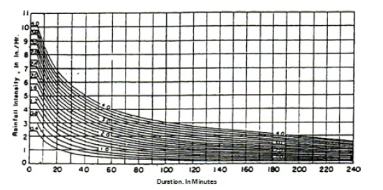
Standard rainfall intensity-duration curves or standard curves.
NOTES: Curve numbers correspond to 1 -h (. values of rainfall or supply indicated by respective curves; all points on the same curve are assumed to have the same average frequency of occurrence. From Engineering Manual by Corps of Engineers. U.S. Army.
Reference: Research report “Recommended Hydrologic Procedures for Computing Urban Runoff from Small Watersheds in Pennsylvania”. Penn State University. January 1982.
EXHIBIT 5-3
TIME OF CONCENTRATION NOMOGRAPH (RATIONAL METHOD)
TIME OF CONCENTRATION NOMOGRAPH (RATIONAL METHOD)
APPENDIX 7-3
TIME OF CONCENTRATION NOMOGRAPH (RATIONAL METHOD)
TIME OF CONCENTRATION NOMOGRAPH (RATIONAL METHOD)
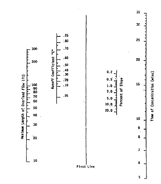
EXHIBIT 5-4
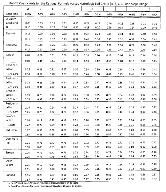
EXHIBIT 5-5
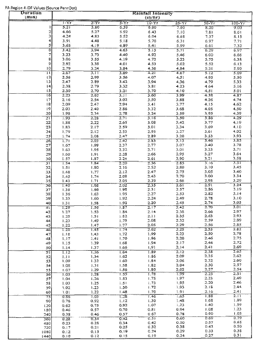
EXHIBIT 5-6
STORMWATER MANAGEMENT REPORT
EXAMPLE FORMAT
1. Table of Contents with page numbers
2. Stormwater Management Summary
3. Project Narrative
4. Pre-Development Hydrograph Calculations
A. Weighted CN Calculations
B. Tc Calculations
C. Hydrographs - 2, 10, 25, 50 and 100 Year Frequencies
5. Post-Development Hydrograph Calculations (for each Drainage Area)
A. Design Point 1 (Drainage Area 1)
1) Weighted CN Calculations
2) Tc Calculations
3) Hydrographs - 1, 2, 10, 25, 50 and 100 Year Frequencies
B. Design Point 2 (Drainage Area 2)
1) Weighted CN Calculations
2) Tc Calculations
3) Hydrographs - 1, 2, 10, 25, 50 and 100 Year Frequencies
6. Post-Development Hydrograph Combinations - Drainage Area 1 and 2
7. Detention Basin Calculations
A. Basin Characteristics
1) Basin Stage Storage - Elevation Data
2) Outlet Structure Configuration
a) Schematic Details: Orifice, Elevation, Cross-Section, Trash Rack, Anti-Seep Collar, Clay Core
3) Basin Routing Table
B. Outflow Hydrographs - 1, 2, 10, 25, 50 and 100 year Frequencies
C. Outfall Protection/Level Spreader Design Calculations
D. Emergency Spillway Calculations
1) Orifice Blocked Outflow Hydrograph - 100 Year Frequency
2) Spillway Sizing-Weir Equation
E. Anti-Seep Collar Calculations
8. Extended Detention of 1 Year Frequency Hydrograph Calculations
9. Basin Empty Time Analysis - 100 Year Storm
10. Best Management Practices (BMP) Calculations and Details
A. Water Quality
1) Volume Calculations
2) BMP Design and Application
B. Groundwater Recharge
1) Geologic Analysis
2) Volume Calculations - 2-Year 24 Hour rainfall
3) BMP Design and Application
11. Conveyance Calculations
A. Pipe Design Calculations
1) Weighted CN Calculations
2) Tc Calculations
3) Peak Flow or Hydrographs, 10, 25 and 100 Year Frequencies
4) Hydraulic Grade Line Calculations, using 10, 25 and 100 Year Frequency Peak Flows
5) Pipe Outlet Lining Calculations - rip-rap or matting
B. Culvert Design Calculations
C. Swale Design Calculations
1) Weighted CN Calculations
2) Tc Calculations
3) Peak Flow or Hydrographs, using 10, 25 and 100 Year Frequencies
4) Capacity Calculations - permanent/lined condition
5) Stability Calculations - temporary and permanent conditions
Appendix A: Pre-Development Drainage Area Map, including Tc information
Appendix B: Post-Development Drainage Area Map, including Tc information
Appendix C: Off Site Drainage Area Map, including Tc information
Appendix D: Inlet Drainage Area Map
Appendix E: SCS Runoff Curve Numbers
Appendix F: Regional Rainfall Curve Chart
Appendix G: C Values for Rational Method
Appendix H: Hydrologic Soul Group Listing
Assumptions:
1. If off-site runoff drains to design point, include calculations under Pre-Development Hydrograph Calculations.
2. If an existing detention facility discharges to the site, the hydrograph analysis to document discharge rate will be added to Pre-Development Hydrograph Calculations using the same format as Post-Development.
3. Hydraulic Grade Line Calculations use a program that considers inlet efficiency and bypass, and ponding over inlets (depth at curb line).
EXHIBIT 5-7
STORMWATER MANAGEMENT SUMMARY
Project: Date:
Drainage Area: ID Number Acres Release Rate:
Note: Use a separate sheet for each Drainage Area.
Design Year Storm Event | ||||||
Discharge Rates: cubic feet per second (cfs)
| 2 | 5 | 10 | 25 | 50 | 100 |
Pre-development discharge | ||||||
Allowable post-development discharge (per release rate) | ||||||
Post-development discharge to SWM facility | ||||||
Post-development bypass | ||||||
Post-development discharge from SWM facility | ||||||
Post-development combined routed discharge | ||||||
WATER QUALITY REQUIREMENTS
Computed Water Quality Volume: cubic feet
Proposed BMP(s) to meet the WQ requirements:
GROUNDWATER RECHARGE REQUIREMENTS
Computed Groundwater Recharge Volume: cubic feet
Proposed BMP(s) to meet GR requirements:
GENERAL PROTECTION REQUIREMENTS
DewateringTime: 1-year storm event: hours
SWM Facility Maximum Capacity: hours
EXHIBIT 5-8
OPERATION AND MAINTENANCE PLAN FOR STORMWATER BMPs
A. INSPECTIONS
1. Stormwater facilities and permanent BMPs must be inspected, at a minimum on an annual basis, or as requested by the Borough, in accordance with this O & M Plan. The property owner has two options:
i. Employing a qualified registered professional to conduct the inspections and prepare reports; or
ii. Entering into an agreement with the Borough for the Borough to conduct the inspections and prepare reports. This can be included in the Stormwater Facilities and Best Management Practices (BMP) Maintenance and Monitoring Agreement (M & M Agreement).
2. If Option i. is chosen, the entity conducting the inspection shall be required to submit a report to the Borough within thirty days following completion of the inspection. The report shall document the condition of the facilities and recommend needed repairs. Recommended repairs and other corrective actions shall be implemented by the property owner within thirty days of the report date.
3. If Option ii. is chosen, the property owner shall be responsible for reimbursing the Borough for the costs involved in accordance with the M & M Agreement.
4. Inspections of open basins shall include but not be limited to:
i. Structural integrity and operation of outlet structures and appurtenances.
ii. Stability of embankments and other soil areas.
iii. Integrity, condition and recharge capacity of vegetation.
iv. Collection, storage and release of stormwater in accordance with the facility design.
v. Sediment accumulation.
vi. Safety.
5. Inspections of subsurface storage facilities shall include but not be limited to:
i. Structural integrity and operation of outlet structures and appurtenances.
ii. Stability of soil over and adjacent to the facility.
iii. Collection, storage and release of stormwater in accordance with the facility design.
iv. Sediment accumulation.
v. Safety.
B. MAINTENANCE
1. Vegetation in and adjacent to basins shall be maintained in accordance with the approved plan, applicable watershed management plans and in accordance with Borough ordinances.
2. Debris shall be removed from basins on a quarterly basis. Floatable debris that may impact operation of the outlet structure shall be removed immediately.
3. Groundwater Recharge and Water Quality BMPs shall be observed quarterly during runoff events to insure operation as designed. BMPs shall be cleaned as required to insure continued operation as designed.
4. Maintenance and observation activities shall be documented in the Inspection Report.
(Ord. 614, 5/11/2015)