For the purpose of this chapter, the following definitions shall apply unless the context clearly indicates or requires a different meaning.
ALLEY. A minor right-of-way privately or publicly owned, primarily for service access to the back or side of properties.
BUILDING INSPECTOR. The officer or other designated authority charged with the administration and enforcement of the building code, or his or her duly authorized representative or agent.
BUILDING LINE. A line parallel to the front property line in front of which no structure shall be erected. This line is established according to the Chapter 154.
COLLECTOR STREET. Collector streets perform the function of collecting traffic from local streets and cul-de-sacs and carrying the traffic to minor and major thoroughfares.
CUL-DE-SAC. A cul-de-sac is a short street having but one end open to traffic and the other end being permanently terminated and a vehicular turn-around provided.
DEDICATION. A gift, by the owner, or a right to use of land for a specified purpose or purposes. Because a transfer of property rights is entailed, DEDICATION must be made by written instrument, and is completed with an acceptance.
EASEMENT. A grant by the property owner of a strip of land for a specified purpose and use by public, corporation or persons.
EXTRA-TERRITORIAL AREA. That portion of the territorial jurisdiction of the Town of Liberty which lies outside the corporate limits of the Town of Liberty.
LOCAL STREET. A local street serves primarily to provide direct access to abutting land and access to higher systems. It offers the lowest level of mobility and through-traffic is usually deliberately discouraged.
LOT.
(1) A portion of subdivision, or any other parcel of land, intended as a unit for transfer of ownership or for development or both.
(2) Includes the words PLOT, PARCEL or TRACT.
LOT OF RECORD. A lot which is part of a subdivision, a plat of which has been recorded in the Office of the Register of Deeds of Randolph County prior to the adoption of this chapter, or a lot described by metes and bounds, the description of which has been so recorded prior to the adoption of the original Subdivision Ordinance, dated September 28, 1981.
LOT TYPES.
CORNER LOT.
(a) Any lot located at the intersection of 2 or more streets.
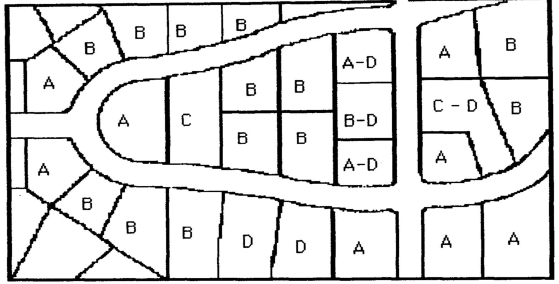
(b) A lot abutting a curved street or streets shall be considered a CORNER LOT if straight lines drawn from the foremost points of the side lot lines to the foremost point of the lot (projected if rounded) meet at an interior angle of less than 135 degrees. (See lots marked A in the diagram above diagram).
INTERIOR LOT. Any lot other than a corner lot and abutting 1 street. Alleys shall not be considered as streets for purposes of this definition.
REVERSED FRONTAGE LOT.
(a) Any lot on which the frontage is at right angles or approximately right angles (interior angles less than 135 degrees) to the general pattern in the area.
(b) A REVERSED FRONTAGE LOT may also be in a corner lot (A-D in the diagram above diagram), an interior lot (B-D) or a through lot (C-D).
THROUGH LOT or a DOUBLE FRONTAGE LOT. Any lot other than a corner lot, and with frontage on more than 1 street. THROUGH LOTS abutting 2 streets (may) shall be referred to as double-frontage lots unless a corner lot. Alleys shall not be considered as streets for purposes of this definition.
MAJOR THOROUGHFARE. Streets that provide for urban areas. These thoroughfares are specifically designated in the Thoroughfare Plan of the Town of Liberty.
MINOR SUBDIVISION. The division of 1 existing tract of land into parcels, whether contiguous or not. No new streets or street extensions shall be included in a MINOR SUBDIVISION.
(G.S. § 160A-376)
MINOR THOROUGHFARE. Minor thoroughfares are important streets in the system and perform the function of collecting traffic from collector streets and carrying it to the major thoroughfare system. MINOR THOROUGHFARES are specifically designated in the Thoroughfare Plan of the Town of Liberty.
OFFICIAL MAPS OR PLANS. Any maps or plans officially adopted by the Town Council as a guide to the development of the Town of Liberty.
OPEN SPACE. An area (land and/or water) generally lacking in humanmade structures and reserved for enjoyment in its unaltered state.
PLAN. Any documented and approved program of recommended action, policy, intention and the like, which sets forth goals and objectives along with criteria, standards and implementing procedures necessary for effectively guiding and controlling decisions relative to facilitating development and growth management.
PLANNED UNIT DEVELOPMENT.
(1) A permitted use designed to provide for developments incorporating a single type or a variety of residential and related uses which are planned and developed as a unit.
(2) This development may consist of individual lots or common building sites.
(3) Common land must be an element of the plan related to effecting the long-term value of the entire development.
PLANNING AND ZONING BOARD. The Planning and Zoning Board of the Town of Liberty, North Carolina.
PLAT. A map or plan of a parcel of land which is to be, or has been, subdivided.
PRIVATE STREET. An undedicated private right-of-way which affords access to abutting properties and requires a subdivision streets disclosure statement in accordance with G.S. § 136-102.6.
PUBLIC SEWAGE DISPOSAL SYSTEM. A system serving 2 or more dwelling units and approved by the Randolph County Health Department or the North Carolina Department of Natural Resources and Community Development, Division of Environmental Management.
PUBLIC STREET. A public right-of-way which affords access to abutting properties and when the rights-of-way are designated as PUBLIC, it shall be presumed to be an offer of dedication to the public.
PUBLIC WATER SUPPLY. Any water supply furnishing potable water to ten or more residences or businesses, or combination of residences or businesses. Approval by the Division of Health Services, Department of Human Resources is required.
RECREATION AREA or PARK. An area of land or combination of land and water resources that is developed for active and/or passive recreation pursuits with various manmade features that accommodate those activities.
RESERVATION. A reservation of land does not involve any transfer of property rights. It simply constitutes an obligation to keep property free from development for a stated period of time.
SHALL. Always mandatory and not merely directory.
STRUCTURE. Includes the word BUILDING.
SUBDIVIDER. Any person, firm or corporation who subdivides or develops any land deemed to be a subdivision as herein defined.
USED FOR. Includes the meaning DESIGNED FOR.
(Ord. passed 5-26-1997)