Overview
The Highway 20 Corridor Overlay District covers extensive areas that are not yet in the city and/or are not yet subdivided. As discussed in Chapter III of this Manual, some of the primary purposes for the creation of the Overlay District and the standards in this Manual are to protect views and vistas to distant landscapes and topography, and to preserve large open spaces and the rural qualities that define much of the existing and desired future character of the Corridor. While designs of individual buildings and building sites have a significant influence on the Corridor's overall visual quality and theme, the pattern of development (i.e. how the development lots are laid out, and the locations and sizes of building areas and open spaces) has an equal or greater influence. Accordingly, this chapter provides standards for subdivisions and other large area developments within 1,200 feet of the centerline of Highway 20 (see Figures VI.1 and VI.2 on the following pages). For purposes of this chapter, "development" shall include all proposed subdivisions and all proposed building projects on parcels of ten acres or larger that were not created as part of a subdivision approved in accordance with this chapter.
Subdivision/Large Area Development Design Standards
A. Required Site Analysis
B. Required Traffic Analysis
C. Nodal Development Concept
D. Significant Vista Corridors
E. Applicability Within Design Districts
F. Nodal Design
1. Nodal Locations
2. Street Hierarchy
3. Public Street Access and Internal Circulation
4. Nodal Dimensions
5. Vista Corridors
6. Nodal Zoning
Figure VI.1 - Significant Vista Corridors and Proposed Intersections
Figure VI.2 - Significant Vista Corridors
A. REQUIRED SITE ANALYSIS
To properly layout development, a comprehensive Site Analysis must be completed first. A description of the requirements for a site analysis are included in Chapter IX of this Manual, which also provides guidance on how to apply the standards contained in this chapter to a particular project. As discussed in Chapter IX, the application of the standards contained in this chapter are contingent upon the presence of historic structures, the natural resources and physical features of a particular site. However, on the whole, when the standards of this chapter are applied on a consistent basis, an appropriate pattern of development will emerge that meets the purposes and goals of the Overlay District.
B. REQUIRED TRAFFIC ANALYSIS
A significant component of subdivision design is the location of streets and access points. This chapter provides standards for creating a continuous public street network and functional access to development sites. However, these standards are fairly general and primarily deal with general street layouts and distances between intersections. What is not covered are detailed street and intersection designs, such as the number of lanes. These parameters are dependent upon projected traffic volumes, which can vary widely between different types of the development. Accordingly, all development shall perform a traffic analysis as described in Chapter IX.
C. NODAL DEVELOPMENT CONCEPT
Unlike the highway itself, development within the Overlay District should not be linear. Instead, development should be concentrated at various nodes centered on key intersections (see Figures VI.1 and VI.2). The Illinois Department of Transportation has restricted direct access to Highway 20 throughout most of the Corridor. Therefore, nearly all new development will take vehicular access from existing streets or those to be dedicated as part of the development.
The limited access will naturally tend to concentrate development at the intersections, based on visibility and accessibility. Sites on the corners will be highly desirable and valuable, while sites further away will be less so. This market-driven response to development concentration reinforces the goal of the Overlay District to maintain views by separating areas of intense development. Accordingly, development generally should be concentrated on corners with smaller lots, less open space, and buildings pulled close to the highway and secondary streets. Between nodes, development should be pulled back from the highway and separated with large expanses of open space to create views and vistas between buildings to the horizon.
D. SIGNIFICANT VISTA CORRIDORS
Significant vista corridors have been identified and are shown on Figures VI.1 and VI.2. The significant vista corridor symbols indicate the portions of Highway 20 from which views are seen, the direction of the views, and the breath of the views. These delineations are approximate and should be field verified and more precisely located before parameters are established for new development design; however, the width of a significant view corridor along the Highway 20 Corridor shall be at least 100 feet.
E. APPLICABILITY WITHIN DESIGN DISTRICTS
The subdivision/large area development design standards are applicable to all project proposals that affect the pattern of development in the Highway 20 Corridor and views to distant landscapes and topography (see Figures VI.1 and VI.2). Projects in the undeveloped Rural Mixed Use District are especially influential and must adhere to the following standards.
New projects proposed for the Hilltop Commercial/ Industrial District must consider nodal design concepts and adhere to the vista corridor standards of this section. These infill projects are also subject to the requirements of Building Site/Small Area Development Design Standards of this Manual. The patterns of development in this District are essentially established, however, it is acknowledged that access points, street hierarchy, and adjacent development are beyond the control of proposed infill projects.
New projects proposed for the Southeast Hilltop District must also consider nodal design concepts and adhere to the vista corridor standards of this section. These infill projects are also subject to the requirements of Building Site/Small Area Development Design Standards of this Manual. Development in this District is essentially built out, however, it is acknowledged that access points, street hierarchy, and adjacent development are beyond the control of proposed infill projects.
New projects proposed for the Downtown Transition District should protect the character of the steep topography and vegetation of this District and strictly follow the existing pattern of development of the National Register Historic District. Because of the limited land areas and the historical sensitivity of this area, no large area developments and the associated patterns of development are possible in this District.
F. NODAL DESIGN
Depending on their location, individual developments may comprise as much as an entire node (all four corners) or as little as one corner. Still others may not include any nodes, but their design and access will be controlled by an existing or future node. The following provisions will be applied based on the specific location of the development. Some developments may need to include all of the design elements identified below, while others may need to address only some. However, the development must be designed based on the design of adjoining development and/or the potential for development on adjoining properties so that, together, adjoining developments create the desired pattern of development described in this chapter.
Please note that unless specified otherwise, for all design standards in this chapter that use Highway 20 as a reference point (such as a minimum distance from Highway 20), the point on Highway 20 so referenced shall be the closest point of the Highway 20 right-of-way.
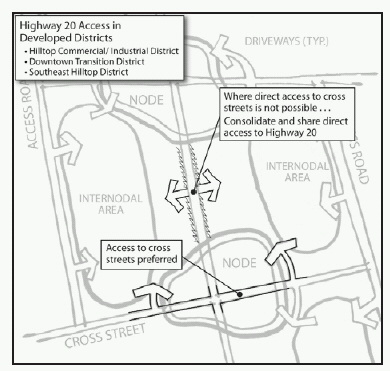
Figure VI.3 Highway 20 Access in Developed Districts
1. Nodal Locations
The Highway 20 Corridor already has an established pattern of nodes spaced about 900 to 1,200 feet apart. Based on this pattern and IDOT access requirements, new node locations are shown on Figures VI.1 and VI.2. As noted, many properties in the Downtown Transition District and Hilltop Commercial/Industrial District currently have direct access to Highway 20. Where possible, these should be removed as development occurs and replaced with access off of existing or new public streets. Where such alternative public streets are not available or possible, the direct private access points should be minimized by consolidating existing points and through shared access agreements and easements between adjacent property owners (see Figure VI.3 above).
Required
Nodes located as shown on Figures VI.1 and VI.2.
Remove existing private direct access points to Highway 20 where possible.
Where access to another street is not possible, consolidate existing private direct access points to Highway 20.
Preferred
Where access to another street is not possible, provide access points to Highway 20 for adjoining properties and provide cross-access easements for on-site circulation and parking.
Discouraged
Where access to another street is not possible, more than one access point to Highway 20 per property.
Prohibited
Where access to another street is not possible, more than two access points to Highway 20 per property.
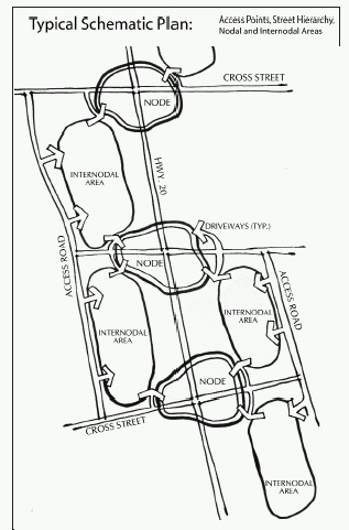
2. Street Hierarchy
Figure VI.4 provides a schematic layout of streets and access points to nodal and internodal areas. For purposes of this chapter,
CROSS STREETS are public streets that intersect with Highway 20 to establish the nodes. The ACCESS ROADS are public streets that generally parallel Highway 20 and function somewhat akin to frontage roads, except that they are located behind the development. The street network is a major foundation block of the development pattern and, as such, has a significant impact on the layout of all subsequent development, both that within the Overlay District as well that located some distance
beyond. In addition, the street network greatly affects the access to individual developments as described in the next section. Accordingly, it is critical that street locations and designs be carefully considered and closely coordinated with adjoining development and properties.
Figure VI.4 Typical Schematic Plan: Access Points, Street Hierarchy, Nodal and Internodal Areas
Required
Cross streets and access roads dedicated as public streets that meet all design requirements of the Galena Subdivision Ordinance.
Cross street intersections with Highway 20 that meet all IDOT design and permitting requirements.
Access roads that cross the entire width of the development unless they would adversely impact a significant vista corridor or other significant natural feature
Cross roads and access roads that follow the natural topography and minimize the destruction of the natural features and resources covered in §§ 154.501 through 154.510.
Continuation of existing cross streets and access roads through the development.
Preferred
Cross street/access road intersections a minimum of 350 feet from Highway 20 intersections, but no greater than 500 feet.
Discouraged
Signalized cross street/access road intersections.
Cross street/access road intersections less than 350 feet from the Highway 20 intersection, but at least 250 feet.
Cross street/access road intersections greater than 500 feet from the Highway 20 intersection, but less than 650 feet.
Prohibited
Cross street/access road intersections less than 250 feet from the Highway 20 intersections.
Cross street/access road intersections greater than 650 feet from the Highway 20 intersection.
Street networks that terminate on the site and do not connect to adjacent properties, except in those instances where the street extension would adversely impact a significant vista corridor or other significant natural feature.
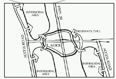
3. Public Street Access and Internal Circulation.
Consistent with IDOT regulations, direct access to Highway 20 is prohibited, with all access provided from a cross street or access road (see Figure VI.5). The location and design of access points must be carefully considered to ensure that the operations of the cross street/Highway 20 and cross street/access road intersections are not adversely affected. This will result in a limited number of access points, and therefore requires that individual developments include internal circulation systems that can be shared by several lots and buildings within the development, as well as existing or future lots and buildings on adjoining properties.
Figure VI.5 Access Roads
Required
Shared access and internal circulation easements shall be recorded for lots and/or building sites within a development and for existing or future lots and buildings on adjoining property that would require shared access in order to meet the access standards of this chapter.
Preferred
Nodal and intemodal access from access roads only.
Driveways on cross streets, where necessary at all, at least 250 feet from the Highway 20 intersection.
Driveways on cross streets, where necessary at all, at least 100 feet from the access road intersection.
Discouraged
Driveways on cross streets, where necessary at all, less than 250 feet from the Highway 20 intersection, but at least 150 feet.
Driveways on cross streets, where necessary at all, less than 100 feet from the access road intersection, but at least 50 feet.
Prohibited
Direct access to Highway 20 (unless required by IDOT).
Driveways on cross streets less than 150 feet from the Highway 20 intersection.
Driveways on cross streets less than 50 feet from the access road intersection.
4. Nodal Dimensions.
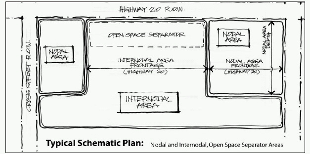
Each corner of a node should be limited to a maximum of three to four acres of intensive development that is pulled up close to the Highway 20 right-of-way and the cross street. Between nodes, development should be separated with extensive areas of open space (open space separators) along Highway 20, with development behind set back a considerable distance. Figure VI. 6 provides a schematic layout of nodal, internodal and open space separator areas.
Required
Development concentrated at nodal corners, except where corners are left open for vista corridors.
Open space separators to be permanently restricted through protective covenants, to which the city is a party, or dedication to the city.
Preferred
Nodal area frontage on Highway 20 of up to 350 feet.
Size of nodal area of two to three acres.
Open space separators with frontage on Highway 20 of at least 50% of the distance between nodal intersections.
Open space separators with a depth of 75 feet or greater.
Discouraged
Nodal area frontage on Highway 20 of greater than 350 feet, but less than 500 feet.
Size of nodal area more than three acres, but less than four acres.
Open space separators with frontage on Highway 20 frontage of less than 50%, but more than 40% of the distance between nodal intersections.
Open space separators with a minimum depth of 50 feet at any one point, but with an average depth of 75 feet or greater.
Prohibited
Nodal area frontage on Highway 20 of greater than 500 feet.
Size of nodal area of four acres or greater.
Open space separators with Highway 20 frontage of 40% or less of the distance between nodal intersections.
Open space separators with a minimum depth of less than 50 feet at any one point, and/or an average depth of less than 75 feet.
Figure VI.6 Typical Schematic Plan: Nodal and Internodal, Open Space Separator Areas
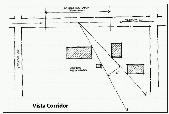
5. Vista Corridors.
As discussed earlier in this Manual, vistas and views to distance hillsides and pastoral landscapes are one of the primary character defining elements of the entire Highway 20 Corridor. The landscape also is punctuated by ravines and other natural features that are striking in their own right, as well as providing wide, unobstructed views to the distance. Figure VI.7 indicates the location of these significant vista corridors. In addition to preserving these, it is important that development between nodes provide additional vista corridors to preserve views and maintain an appropriate amount of open space and separation of buildings along the Corridor. Figure VI.7 is a sketch of a vista corridor that complies with the standards provided in this section.
Figure VI.7 Vista Corridor
Required
Preservation of the significant vista corridors as shown on Figures VI.1 and V1.2 in accordance with the provisions of this section.
A minimum of two viewsheds between each nodal intersection.
The apex of a viewshed shall be located five feet above the Highway 20 centerline and the viewshed shall have a 14º angle; however, no area of the viewshed shall be less than 50 feet wide.
The apex of a viewshed shall be located in front of, and the entire width of the viewshed shall cross, an open space separator located adjacent to Highway 20.
The viewshed across the open space separator shall be free of paving and all site improvements, including landscaping taller than three feet.
Viewsheds where the land line (as opposed to the tree line) of the winter horizon remains discernibly unbroken by buildings or site improvements of any kind.
Preferered
Three or more viewsheds between each nodal intersection.
Continuation of viewshed established on other properties.
Viewshed with paving or site improvements of any kind, including landscaping taller than three feet located 150 feet or greater from Highway 20.
Viewsheds with no buildings or buildings located a minimum of 1,000 feet from Highway 20.
Discouraged
Disruption of viewsheds established on other properties.
Viewsheds with paving or site improvements of any kind, including landscaping taller than three feet located less than 150 feet from Highway 20, but more than 75 feet.
Viewsheds with buildings located at least 500 feet from Highway 20, but less than 1,000 feet.
Prohibited
Viewsheds with paving or site improvements of any kind, including landscape materials taller than three feet, located within an open space separator adjacent to Highway 20.
Viewsheds with site improvements of any kind, including landscaping taller than three feet, located within 75 feet of Highway 20.
Viewsheds with buildings located less than 500 feet from Highway 20.
Viewsheds where the winter horizon line is broken by buildings or site improvements of any kind.
C. Nodal Zoning.
The City of Galena Zoning Ordinance, Chapter 154, has been revised simultaneously with the development of this Manual so that the two may work in concert with one another. Specifically, several zoning districts have been developed for use within the Highway 20 Corridor , as well as elsewhere in the community, and to further the goals and objectives the adopted Comprehensive Plan.
Required
Zoning districts consistent with the adopted Comprehensive Plan and proposed land use map included with the Plan.
Preferred
For nodal residential areas, the High Density Residential (HDR) District or Planned Unit Development/Traditional Neighborhood Development that uses the HDR District as the base district.
For internodal residential areas, High Density Residential (HDR) District, or Planned Unit Development/Traditional Neighborhood Development that uses the HDR District as the base district.
For nodal commercial areas, the Planned Commercial (PC) District, or Planned Unit Development/Traditional Neighborhood Development that uses the PC District as the base district.
For internodal commercial areas, the Planned Office (PO) or Planned Commercial (PC) Districts, or Planned Unit Development/ Traditional Neighborhood Development that uses either the PO or PC Districts as the base district.
For nodal and internodal industrial areas, the Planned Industrial (PI) District, or Planned Unit Development that uses the PI District as the base district.
Discouraged
For internodal residential areas, the High Density Residential (HDR) District.
For nodal commercial areas, the Planned Office (PO) District or Planned Unit Development/ Traditional Neighborhood Development that uses PO District as the base district.
Prohibited
For nodal residential areas, the Countryside Residential (CSR) and Low Density Residential (LDR) Districts, and Planned Unit Development/ Traditional Neighborhood Development that uses either the CSR or LDR Districts as the base district.
For internodal residential area, the Countryside Residential (CSR) District, or Planned Unit Development/Traditional Neighborhood Development that uses the CSR District as the base district.
For nodal commercial areas, any office or commercial district other than the Planned Commercial (PC) or Planned Office (PO) Districts, and Planned Unit Development/ Traditional Neighborhood Development that uses an office or commercial district other than the PO or PC District as the base district.
For internodal commercial areas, any office or commercial district other than Planned Office (PO) or Planned Commercial (PC) Districts, and Planned Unit Development/Traditional Neighborhood Development that uses any office or commercial district other than the PO or PC District as the base district.
For nodal industrial areas, any industrial district other than Planned Industrial (PI), and Planned Unit Development that uses any industrial district other than the PI District as the base district.
For internodal industrial areas, the Heavy Industrial (HI) District, and Planned Unit Development that uses the HI District as the base district.