For the purposes of this Zoning Ordinance, certain terms and words are hereby defined. Certain sections contain definitions that are additional to those listed here. Where terms are not specifically defined, their ordinarily accepted meaning or meanings implied by their context shall apply.
1. Abutting: Having lot lines or district boundaries in common. Use interchangeably with adjacent.
2. Accessory Structure: A structure that is incidental to and customarily associated with a specific principal use or building on the same site.
3. Accessory Use: A use that is incidental to and customarily associated with a specific principal use on the same site.
4. Addition: Any construction that increases the size of a building or structure in terms of site coverage, height, length, width, or gross floor area.
5. ADT or Average Daily Traffic: The average number of motor vehicles per day that pass over a given point or segment of street.
6. Agent of Owner: Any person showing written verification that he/she is acting for, and with the knowledge and consent of, a property owner.
7. Alley: A public right of way, other than a street and twenty feet or less in width which is used as a secondary means of access to abutting property.
8. Alteration: Any construction or physical change in the internal arrangement of spaces, the supporting members, the positioning on a site, or the appearance of a building or structure.
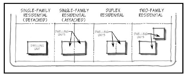
9. Apartment: A housing unit within a building designed for and suitable for occupancy by only one family. Apartments are generally located within multi-family residential buildings.
10. Approving Authority: The City Council of the City of Denison or its designee.
11. ASCE: The American Society of Civil Engineers.
12. Attached: Having one or more walls in common with a principal building or connected to a principal building by an integral architectural element, such as a covered passageway; facade wall extension; or archway.
13. Base Zoning District: A district established by this Ordinance that prescribes basic regulations governing land use and site development standards. No more than one Base Zoning District shall apply to any individually platted lot or parcel unless the lot or parcel is part of a Planned Unit Development.
14. Basement: A level of a building below street level that has at least one-half of its height below the surface of adjacent ground. A basement used for independent dwelling or business purposes shall be considered a story for the purposes of height measurement.
15. Beginning of Construction: The initial incorporation of labor and materials within the foundation of a building or structure.
16. Bicycle Lane and Path: A designated lane on a roadway or an exclusive path separated from a roadway, designed specifically to accommodate the physical requirements of bicycling. Bicycle paths are ordinarily designed to accommodate other forms of non-motorized transportation or recreational movement, but will also accommodate motorized vehicles, such as motorized wheelchairs, designed specifically to provide access to people with disabilities.
17. Block: An area of land within a subdivision that is entirely bounded by streets and/or the exterior boundaries of the subdivision, or by a combination of the above with a watercourse, lake, railroad, or other significant natural or man-made barrier, and which has been designated as such on a plat for the purposes of legal description of a property.
18. Block Face: The property abutting one side of a street and lying between the two nearest intersection streets, or between the one nearest intersecting street and a major physical barrier, including, but not limited to, railroads, streams, lakes, or the corporate limits of Denison.
19. Board of Adjustment: A body, established by the City expressly for the purpose of granting relief from situations of hardship and to hear appeals as provided by this Ordinance.
20. Boulevard: A public street generally characterized by a wider than normal right-of-way and extensive green space in relation to pavement surface. Boulevards may either include dual street channels separated by a landscaped median; or by a single street channel with wider than normal greenway setbacks behind the curb.
21. Bufferyard: A landscaped area around the perimeter of a tract of land, usually intended to separate and partially obstruct the view of two adjacent land uses or properties from one another.
22. Building: A structure entirely separated from any other structure by space or by walls and having a roof and built to provide shelter, support, or enclosure for persons or property.
23. Building Coverage: The at-grade area of a site covered by buildings or roofed areas, excluding allowed projecting eaves, balconies, and similar features, also referred to as the building footprint.
24. Building Elevation: An exterior wall of a building exposed to public view.
25. Building Envelope: The three-dimensional space within which a structure is permitted to be built on a lot after all zoning and other applicable municipal requirements have been met.
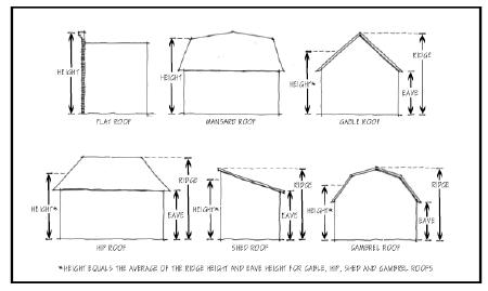
26. Building Height: The vertical distance from the established grade to the highest point of the coping of a flat roof, the deck line of a mansard roof, or to the average height between eaves and the ridge for gable, hip, shed, or gambrel roofs. For other cases, height shall be measured as the vertical distance from the established grade to the highest point of a structure as herein defined. Where a building or structure is located on a slope, height shall be measured from the average grade level adjacent to the building or structure.
27. Building Line: The outer boundary of a building established by the location of its exterior walls.
28. Building Official: The city official, designated by the City Council, who is responsible for the enforcement of the applicable building code and conditional uses.
29. Building Permit: A document that must be issued by the Building Official prior to erecting, constructing, enlarging, altering, moving, improving, removing, converting, or demolishing any building or structure on a platted lot/s or a parcel exceeding ten (10) acres in size as regulated by this Ordinance or by the applicable building codes of the City of Denison. Issuance of a building permit follows review of plans by the Building Official to determine that the proposed use of building or land complies with the provisions of the Zoning Ordinance.
30. Business: Activities that include the exchange or manufacture of goods or services on a site.
31. Business Center: A building containing more than one commercial business, or any group of non-residential buildings within a common development, characterized by shared parking and access.
32. Cartway (or Road or Street Channel): The actual surface area of a road used to accommodate motor vehicles, including moving traffic lanes, acceleration and deceleration lanes, and parking lanes. On a street with curbs, the cartway is measured from back to back of curbs. On streets without curbs, the cartway is measured between the outer edges of the pavement.
33. Centerline Offset: The distance between the centerline of roads intersecting a common road from the same or opposite sides.
34. Certificate of Occupancy: An official certificate issued by the Building Official prior to occupancy of a completed building or structure, upon finding of conformance with the applicable building code and this Zoning Ordinance.
35. Change of Use: The replacement of an existing use type by a new use type.
36. Channel: The bed or banks of a natural stream or drainageway that convey the constant or intermittent flow of water, including storm run-off.
37. City: The City of Denison, Iowa.
38. City Council: The City Council of Denison, Iowa.
39. Common Area: An area held, designed, and designated for common or cooperative use within a development.
40. Common Development: A development proposed and planned as one unified project not separated by a public street or alley.
41. Common Open Space: Land within or related to a development that is not individually owned or dedicated for public use, designed and generally intended for the common use of the residents of the development.
42. Compatibility: The degree to which two or more different land use types are able to exist together in close proximity, with no one use having significant negative effects on any other use.
43. Comprehensive Plan: The duly adopted Comprehensive Development Plan of the City of Denison.
44. Concept Plan: A preliminary presentation that includes the minimum information necessary, as determined by the Zoning Administrator, to be used for the purpose of discussion or classification of a proposed plat prior to formal application.
45. Condominium: An ownership regime whereby the title to each unit of occupancy is held in separate ownership, and the real estate on which the units are located is held in common ownership solely by the owners of the units with each owner having an undivided interest in the common real estate. Condominiums may include residential, commercial, office, or industrial uses.
46. Conservation Development: A development design technique that concentrates buildings in specific areas on a site to allow remaining land to be used for recreation, common open space, or the preservation of historically or environmentally sensitive features.
47. Conservation (or Cluster) Subdivision: Wholly or in majority, a residential subdivision that permits a reduction in lot area, setback, or other site development regulations, provided 1) there is no increase in the overall density permitted for a conventional subdivision in a given zoning district, and 2) the remaining land area is used for common space.
48. County: Crawford County, Iowa.
49. Courtyard: An open, unoccupied space, bounded on two or more sides by the walls of the building.
50. Conventional Subdivision: A subdivision which literally meets all nominal standards of the Zoning Ordinance for lot dimensions, setbacks, street frontage, and other site development regulations.
51. Creative (or Innovative) Development or Subdivision: A subdivision that, while complying with the Subdivision Ordinance, diverges from nominal compliance with site development regulations in the Zoning Ordinance. Creative subdivisions imply a higher level of pre-planning than conventional subdivisions. They may be employed for the purpose of environmental protection or the creation of superior community design. Types of Creative Subdivisions include Conservation Subdivisions and Traditional Neighborhood Districts.
52. Cul-de-sac: A local street with only one outlet and with an opposite end providing for the reversal of traffic.
53. Curb: A vertical or sloping edge of a roadway, intended to define the edge of the cartway and to channel or control drainage.
54. Dedication: A grant of land to the City or another public agency for a public purpose.
55. Density: The amount of development per specific unit of a site.
56. Design standards: Standards that set forth specific improvement requirements.
57. Detached: Fully separated from any other building or not jointed to another building in such a manner as to constitute an enclosed or covered connection.
58. Detention basin: An artificial or natural water collection facility, designed to collect surface or subsurface water and to control its rate of discharge, in order to prevent a net increase in the rate of water flow that existed prior to a development.
59. Developer: The legal owner(s) or authorized agent of any land engaged in a proposed development.
60. Development: A planning or construction project involving substantial improvement or change in the character and/or land use of a property.
61. Divided street: A street with opposing lanes separated by a median strip, center island, or other form of physical barrier, which cannot be crossed except at designated locations.
62. Drive-in Services: Uses that involve the sale of products or provision of services to occupants in vehicles.
63. Drainage: The removal of surface or ground water from land by drains, grading, or other means.
64. Drainage system: The system through which water flows from the land.
65. Driveway: A permanently paved, surfaced area providing vehicular access between a street and an off-street parking or loading area.
66. Dwelling Unit: One or more rooms, designed, occupied or intended for occupancy as a separate place of residence, with cooking, sleeping, and sanitary facilities provided within the dwelling unit for the exclusive use of one family, as defined in this section, maintaining a household.
67. Easement: A privilege or right of use granted on, above, under, or across a particular tract of land for a specific purpose by one owner to another owner, public or private agency, or utility, where fee simple title remains with the property owner.
68. Enclosed: A roofed or covered space fully surrounded by walls.
69. Existing Use: The use of a lot or structure at the time of the effective date of this Ordinance.
70. Family: One or more persons living together and sharing common living, sleeping, cooking, and eating facilities within an individual housing unit, not more than three of whom may be unrelated. The following persons are considered related for the purpose of this definition:
A. Persons related by blood, marriage or adoption within the third degree of consanguinity.
B. Persons residing with a family for purposes of adoption.
C. Not more than eight persons residing with a family for the purpose of receiving foster care licensed or approved by the State.
D. Persons living with a family at the direction of a court.
71. Fascia: A parapet-type wall used as part of the facade of a flat-roofed building and projecting no more than six feet from the immediately adjacent building face. Such a wall shall enclose at least three sides of the projecting flat roof and return to the parapet wall or the building.
72. Federal: Pertaining to the Government of the United States of America.
73. Final Plat Approval: The final official action of the City Council, upon a recommendation by the Planning Commission, permitting the filing of a subdivision with the Crawford County Register of Deeds and the conveyance of individual parcels and lots to subsequent owners.
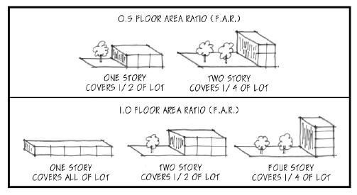
74. Floor Area Ratio (FAR): The quotient of gross floor area of all buildings on a site divided by gross site area of the site.
75. Frontage: The length of a property line of any one premise abutting and parallel to a public street, private way, or court from which access is permitted.
76. Garage: An accessory building or portion of a main building used primarily for storage of motor vehicles.
77. Grade: The elevation of the finished surface of ground, paving, or sidewalk adjacent to any building line.
A. For buildings having walls facing one street only, the grade shall be the elevation of the ground at the center of the wall facing the street.
B. For buildings having walls facing more than one street, the grade shall be the average elevation of the grades of all walls facing each street.
C. For buildings having no walls facing a street, the grade shall be the average level of the finished surface of the ground adjacent to the exterior walls of the building.
78. Gross Floor Area (GFA): The total enclosed horizontal area of all floors of a building, measured to the inside surfaces of the exterior walls. This definition excludes the areas of mechanical equipment rooms, elevator shafts, airspaces above atriums, and enclosed off-street parking and loading areas serving a principal use.
79. Home Based Business/Home Occupation means an occupation or profession which:
A. Is customarily carried on in a dwelling unit or in a building or other structure accessory to a dwelling unit, and
B. Is carried on by a member of the family residing in the dwelling unit, employing no more than two persons outside of the immediate family residing on the premises, and
C. Is clearly incidental and secondary to the use of the dwelling unit for residential purposes, and
D. Has no exterior display, no exterior storage of materials and no other exterior indication of the home occupation or variation from the residential character of the principal building, and
E. Does not occupy more than twenty-five percent (25%) of the area of one floor of the dwelling unit, and
F. Has not more than one exterior sign which sign does not exceed twelve square feet in area, and
G. Produces no offensive noise, vibration, smoke, dust, odor, heat or glare rendering such building or premises objectionable or detrimental to the residential character of the neighborhood, and causes no electrical interference with radio or television reception in the neighborhood.
80. Impervious coverage: The total horizontal area of all buildings, roofed or covered spaces, paved surface areas, walkways and driveways, and any other site improvements that decrease the ability of the surface of the site to absorb water, expressed as a percent of site area. The surface water area of swimming pools is excluded from this definition.
81. Landscaped Area: The area within the boundaries of a given lot, site or common development consisting primarily of plant material, including but not limited to grass, trees, shrubs, vines, ground cover, and other organic plant materials; or grass paver masonry units installed such that the appearance of the area is primarily landscaped.
A. Perimeter Landscaped Area: Any required landscaped area that adjoins the exterior boundary of a lot, site or common development.
B. Interior Landscaped Area: Any landscaped area within a site exclusive of required perimeter landscaping.
82. Lane: An approved private right-of-way that provides access to residential properties and meets at least three of the following conditions:
A. Serves twelve or fewer housing units or platted lots.
B. Does not function as a local street because of its alignment, design, or location.
C. Is completely internal to a development.
D. Does not exceed 600 feet in length.
83. Loading Area: An off-street area used for the loading or unloading of goods from a vehicle in connection with the use of the site on which such area is located.
84. Lot: A platted parcel of property with a separate and distinct number or other identifying designation which has been created, assigned and recorded in the Office of the Crawford County Register of Deeds. Each individual lot is subject to the provisions of a particular base Zoning District, and shall have a minimum frontage of 20 feet, except as provided in an approved Planned Unit Development, Conservation Development, or Traditional Neighborhood Development.
A. Corner Lot: A lot located at the junction of at least two streets, private ways or courts or at least two segments of a curved street, private way or court, at which the angle of intersection is no greater than 135 degrees.
B. Double Frontage Lot: A lot, other than a corner lot, having frontage on two non-intersecting streets, private ways or courts. Primary access shall be restricted on a double frontage lot to the minor of the two streets or to the front line as determined at time of platting or as defined by this ordinance. (Also known as a Through Lot)
C. Interior Lot: A lot other than a corner lot whose sides do not abut a street.
D. Common Development Lot: When two or more contiguous lots are developed as part of a single development, these lots may be considered a single lot for purposes of this ordinance.
E. Lot of Record: A lot which is part of a subdivision, the deed of which has been recorded in the office of the County Recorder.
F. Reverse Corner Lot: A corner lot, the side street line of which is substantially a continuation of the front line of the first lot to its rear.

85. Lot Area: The total horizontal area within the lot lines of a lot.
86. Lot Depth: The mean horizontal distance measured between the front and rear lot lines.
87. Lot Line: A property boundary line(s) of record that divides one lot from another lot or a lot from the public or private street right-of-way or easement.
A. Front Lot Line: The lot line separating a lot and a public or private street right-of-way or easement.
(1) For an interior lot, the lot line separating the lot from the right-of-way or easement.
(2) For a corner lot, the shorter lot line abutting a public or private street or easement. In instances of equal line dimension, the front lot line shall be determined by the Building Official, or as may be noted on the final plat.
(3) For a double frontage lot, the lot lines separating the lot from the right-of-way or easement of the more minor street. In cases where each street has the same classification, the front lot line shall be determined by the Building Official at the time of application for the original building permit for the lot, or as may be noted on the final plat.
B. Rear Lot Line: The lot line that is opposite and most distant from the front line.
C. Side Lot Line: Any lot line that is neither a front or rear lot line. A side lot line separating a lot from a street, private way or court is a street side lot line. A side lot line separating a lot from another lot or lots is an interior side lot line.
88. Lot Width: The horizontal distance measured between the side lot lines of a lot, at right angles to its depth along a straight line parallel to the front lot line at the minimum required building setback line.
89. Main: The principal artery of a system of continuous piping which conveys fluids and to which branches may be connected.
90. Major subdivision: Any subdivision not defined and approved as a minor subdivision.
91. Manufactured Home Dwelling: A dwelling unit built in compliance with National Manufactured Housing Construction and Safety Standards Act, 42USC 5401 to 5426 et seq., and the regulations promulgated by the United States Department of Housing and Urban Development, and when constructed shall bear the seal of the Department of Health and Human Services Regulation and Licensure as required by the State of Iowa.
A. Dwelling units built in compliance with the above may be placed in any zoning district where single-family dwelling units are permitted when the following additional requirements are met:
(1) Any dwelling unit shall have no less than nine hundred (900) square feet of floor area.
(2) Any dwelling shall have no less than eighteen (18) feet exterior width.
(3) The roof shall be pitched with a minimum vertical rise of two (2) and one-half (1/2) inches for each twelve (12) inches of horizontal run.
(4) The exterior shall be of a color, material and scale comparable with existing residential site-built single-family dwellings. The home shall have a non-reflective roof material.
(5) The dwellings shall have wheels, axles, transporting lights, and removable towing apparatus removed if present.
(6) The dwelling shall be placed upon a permanent foundation approved by the City of Denison.
(7) All utility services shall be directly connected to the structure.
B. Manufactured homes which do not meet all of the standards above, may be placed in a manufactured home park or as permitted by code, provided the structure is transportable in one (1) or more sections which in the traveling mode are eight (8) body feet or more in width or forty (40) body feet or more in length or, when erected on site, are three hundred twenty (320) or more square feet and which are built on a permanent chassis and designed to be used as a dwelling with or without a permanent foundation when connected to the required utilities and includes the plumbing, heating, air-conditioning and electrical systems contained therein.
92. Minor subdivision: A subdivision of land which creates no more than four lots from any single parcel of land; requires no extension of streets, sewers, utilities, or other municipal facilities; no dedication of easements or rights-of-way or annexation; complies with all pre-existing zoning requirements; and has not been subject to a previous administrative or minor subdivision.
93. Mixed Use Building: A building or structure that incorporates two or more use types within a single building or structure, provided that each use type is permitted within the individual Base Zoning District in which the building or structure is to be located.
94. Mixed Use Development: A single development that incorporates complementary land use types into a single development.
95. Mobile Homes: A building type designed to be transportable in one or more sections, constructed on a permanent chassis or undercarriage, and designed to be used as a dwelling unit or other use with or without a permanent foundation when connected to the required utilities, but not bearing a seal attesting to the approval and issuance of the Iowa Department of Health or conformance to the manufactured home procedural and enforcement regulations, as adopted by the US Department of Housing and Urban Development; or not otherwise satisfying the definition of Manufactured Home Dwellings.
96. Mobile Home Park: A unified development under single ownership, developed, subdivided, planned, and improved for the placement of mobile home units for non-transient use. Mobile Home Parks include common areas and facilities for management, recreation, laundry, utility services, storage, and other services; but do not include mobile home sales lots on which unoccupied mobile homes are parked for the purposes of display, inspection, sale, or storage.
97. Mobile Home Subdivision: A development subdivided, planned, and improved for the placement of mobile home units on lots for uses by the individual owners of such lots. Mobile Home Subdivisions may include common areas and facilities for management, recreation, laundry, utility services, storage, and other services; but do not include mobile home sales lots on which unoccupied mobile homes are parked for the purpose of display, inspection, sale, or storage.
98. Monument: An identification marker established by a registered land surveyor at each section corner, block corner, lot corner, or other point as required by this Ordinance.
99. Moving lane: Any traffic lane within a cartway where traffic movement is the primary or sole function.
100. Nonconforming Development: A building, structure, or improvement which does not comply with the regulations for its zoning district set forth by this Zoning Ordinance but which complied with applicable regulations at the time of construction.
101. Nonconforming Lot: A lot which was lawful prior to the adoption, revision, or amendment of this Zoning Ordinance but that fails by reason of such adoption, revision, or amendment to conform to the present requirements of the Zoning Ordinance. No action can be taken which would increase the non-conforming characteristics of the lot.
102. Nonconforming Sign: A sign that was legally erected prior to the adoption, revision, or amendment of this Zoning Ordinance but that fails by reason of such adoption, revision, or amendment to conform to the present requirements of this Zoning Ordinance.
103. Nonconforming Structure: A structure which was lawful prior to the adoption, revision, or amendment of this Zoning Ordinance but that fails by reason of such adoption, revision, or amendment to conform to the present requirements of the Zoning Ordinance. No action can be taken which would increase the non-conforming characteristics of the structure.
104. Nonconforming Use: A land use which was lawful prior to the adoption, revision, or amendment of this Zoning Ordinance but that fails by reason of such adoption, revision, or amendment to conform to the present requirements of the Zoning Ordinance. No action can be taken which would increase the non-conforming characteristics of the land use.
105. Nuisance: An unreasonable and continuous invasion of the use and enjoyment of a property right which a reasonable person would find annoying, unpleasant, obnoxious, or offensive.
106. Off-site: Located outside the boundaries of the parcel that is the subject of an application.
107. Open Space: Area included on any site or lot that is open and unobstructed to the sky, except for allowed projections of cornices, overhangs, porches, balconies, or plant materials.
108. Outdoor Storage: The storage of materials, parts, or products that are related to the primary use of a site for a period exceeding three days.
109. Overlay District: A district established by this Ordinance that prescribes special regulations to be applied to a site only in combination with a base district.
110. Owner: An individual, firm, association, syndicate, partnership, or corporation having sufficient proprietary interest to seek development of land.
111. Parking Facility: An area on a lot and/or within a building, including one or more parking spaces, along with provision for access circulation, maneuvering, and landscaping, meeting the requirements of this Zoning Ordinance. Parking facilities include parking lots, private garages, and parking structures. Vehicle storage is a use distinct from parking. Vehicle storage is also governed by applicable provisions of Chapter 172.
112. Parking Lane: A lane located on the sides of streets, designated or allowing on-street parking of motor vehicles.
113. Parking Spaces: An area on a lot and/or within a building, intended for the use of temporary parking of a personal vehicle. This term is used interchangeably with “parking stall”. Each parking space must have a means of access to a public street. Tandem parking stalls in single-family detached, single-family attached, and townhouse residential uses shall be considered to have a means of access to a public street.
114. Paved: Permanently surfaced with poured concrete, concrete pavers, or asphalt.
115. Performance Bond: A surety bond or cash deposit posted by a contractor or developer made out to the city in an amount equal to the full cost of the improvements. The bond amount shall be that of the contract price and shall be legally sufficient to secure to the City that said improvements will be constructed in accordance with the terms of the contract documents within a period specified by this Ordinance.
116. Permitted Use: A land use type allowed as a matter of right in a zoning district, subject only to special requirements of this Zoning Ordinance.
117. Planning Commission: The Planning Commission of the City of Denison.
118. Planning Director: The City Manager.
119. Planned Unit Development: A development of land which is under unified control and is planned and developed as a whole in a single development operation or programmed series of development stages. The development may include streets, circulation ways, utilities, buildings, open spaces, and other site features and improvements.
120. Plat: A document, usually a map or maps, expressing the designation or division of land into one or more lots or parcels, any one of which is ten acres or less. Plats include preliminary and final plats.
A. Preliminary Plat: A plat indicating the proposed layout of a development and related information, intended for the purpose of preliminary approval by approving authorities but not for filing with the Crawford County Register of Deeds.
B. Final Plat: The final map of the subdivision which is presented for Final Approval. The Final Plat contains detailed information and documentation and is designed to be filed with the Register of Deeds.
121. Porch, Unenclosed: A roofed or unroofed open structure projecting from an exterior wall of a building and having no enclosed features more than thirty inches above its floor other than wire screening and a roof with supporting structure.
122. Premises: A lot, parcel, tract or plot of land, contiguous and under common ownership or control, together with the buildings and structure thereon.
123. Principal use: The main use of land or structures as distinguished from an accessory use.
124. Private Garage: A building for the storage of motor vehicles where no repair service facilities are maintained and where no motor vehicles are kept for rental or sale.
125. Property Line: The boundary between separate property ownerships, as recorded by the legal description of a parcel and defined by the Crawford County Register of Deeds. In subdivisions, property lines are usually but not in every case coincident with lot lines.
126. Recreational Vehicle: A vehicle towed or self propelled on its own chassis or attached to the chassis of another vehicle and designed or used for temporary dwelling, recreational, or sporting purposes. Recreational vehicles include, but are not limited to, travel trailers; campers; motor coach homes; converted buses and trucks, boats, and boat trailers.
127. Regulation: A specific requirement set forth by this Zoning Ordinance that must be followed.
128. Remote Parking: A supply of off-street parking at a location not on the site of a given development.
129. Right-of-way: A strip of land, generally linear, occupied or intended to be occupied by a system that conveys people, traffic, fluids, utilities, or energy from one point to another. Rights-of-way may include streets and roads, crosswalks, bicycle paths, recreational trails, railroads or fixed guideway transit, electric transmission lines, gas pipelines, water mains, or sewer mains.
130. Rural Subdivisions: A residential subdivision located more than one-half mile past the corporate limits but within the two mile planning jurisdiction of the City; or outside of areas designated for future urban development by the Comprehensive Plan.
131. Salvage Yard (or Salvage Services): Places of business engaged in the storage, sale, dismantling or other processing of used or waste materials that are not intended for reuse in their original forms, including automotive wrecking yards, junkyards, or paper salvage yards.
132. Sanitary Sewer: A sewer that conducts sanitary wastes from a point of origin to a treatment or disposal facility. In developing areas, sanitary sewers normally include interceptor, outfall, local, and lateral sewers.
A. Interceptor: A sanitary sewer that serves as a trunk, collecting sewage generated by a number of individual developments.
B. Outfall: A sanitary sewer that may be developed to connect an individual subdivision or development to an interceptor sewer.
C. Local: A pipe that connects lateral sewers to an outfall or interceptor sewer.
D. Lateral: A private service line connecting buildings to local sewers.
133. Septic system: An underground system, utilizing a watertight receptacle to receive the discharge of sewage and a soil absorption leach field, which provides for the decomposition of wastes produced by development on a single lot.
134. Screening: The method by which a view of one site from another adjacent site is shielded, concealed, or hidden. Screening techniques include fences, walls, hedges, berms, or other features as may be permitted by the landscape provisions of this ordinance.
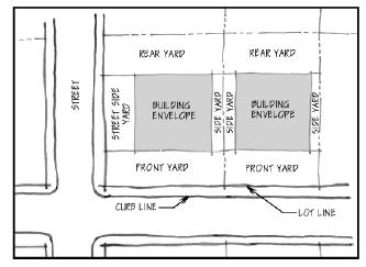
135. Setback: The distance, as required by the minimum setback(s) which establishes the horizontal component(s) of the building envelope.
136. Sidewalk: A paved path provided for pedestrian use, usually located at the side of and detached from a road, but within the right-of-way.
137. Sign: A symbolic, visual device fixed upon a building, vehicle, structure, or parcel of land, which is intended to convey information about a product, business, activity, place, person, institution, candidate, or political idea.
138. Site: The parcel of land to be developed or built upon. A site may encompass a single lot; or a group of lots developed as a common development under the special and overlay districts provisions of this ordinance.
139. Site Plan: A plan, prepared to scale, showing accurately and with complete dimensioning, the boundaries of a site and the location of all buildings, structures, uses, and principal site development features proposed for a specific parcel of land; and any other information that may be reasonably requested by the City in order that an informed decision can be made on the associated request.
140. Special Use Permit: An approval of a use with operating and/or physical characteristics different from those of permitted uses in a given zoning district which may, nonetheless, be compatible with those uses under special conditions and with adequate public review. Special uses are allowed in a zoning district only at the discretion of and with the explicit permission of the Planning Commission.
141. State: The State of Iowa.
142. Storm Sewer: A conduit that conducts storm drainage from a development or subdivision, ultimately to a drainageway or stream.
143. Story: The portion of a building included between the surface of any floor and the surface of the next floor above it; if there is no floor above it, the space between such floor and the next ceiling above it. A half story is a story under a sloped roof, the wall heights of which on at least two opposite, exterior walls are less than four feet.
144. Street: Land dedicated for public use, from right-of-way line to right-of-way, which affords a primary means of access to the abutting property. Streets may be categorized in a hierarchy or conceptual arrangement of streets based on function. The hierarchical approach classifies streets from courts or lanes, which provide private access to a limited number of lots, to arterials, which accommodate large volumes of high-speed, regional traffic. Street types contained within the hierarchy include:
A. Court or lane
B. Local
C. Collector
D. Expressway
E. Minor Arterial
F. Major Arterial
145. Street, Arterial: Street or highways intended to provide for through traffic movement between areas of the city or across the city. Major arterials usually imply relatively high speeds and traffic volumes, and are often subject to control of access to individual properties. Minor arterials are generally intended to provide trips of moderate lengths and imply lower operating speeds and more frequent points of local access than major arterial streets.
146. Street, Collector: A street connecting neighborhoods within the same communities, designed to carry traffic from local to arterial streets.
147. Street, Designed: A future street designated on the Comprehensive Development Plan to insure traffic carrying capacity between neighborhoods, connections between neighborhoods and major activity centers and accommodation of major through traffic. Such streets may be designated as collectors, arterials or expressways with the tentative location of the street shown on the Transportation Plan.
148. Street, Expressway: A major street with limited access for high traffic speeds and volumes designed to move traffic around the city rather than through it.
149. Street, Intersecting and Principal: In regard to a site, the principal street shall be the street to which the majority of lots on a blockface are oriented; the intersecting street shall be a street other than a principal street.
150. Street, Local: A street which is used primarily for access to the abutting properties.
151. Street, Major: A street carrying traffic between neighborhoods, connecting neighborhoods with major activity centers, or accommodating major through traffic. Major streets are designated as collectors, arterials, or expressways by the Comprehensive Development Plan.
152. Street Yard: The distance between a lot line adjacent to a public street and the wall or façade of a building parallel to such lot line. If the building wall is not parallel to the lot line, the street yard depth shall be the distance between the street lot line and a parallel line that equals the average distance of the building wall or façade from the street lot line.
153. Structure: Any object constructed, erected or built, the use of which requires more or less permanent location on the ground and which is designed for the support, enclosure, shelter or protection of persons, animals, chattels or property of any kind, including but without limiting the generality of the foregoing, installations such as signs, billboards, radio towers and other facilities not designed for storage of property or occupancy by persons.
154. Subdivision: The division of a lot, tract, or parcel into two or more lots, tracts, parcels, or other units of land for title transfer or development, when one of the resultant lots is equal to ten acres or less.
155. Townhouse: A dwelling unit having a common wall with or abutting one or more adjacent dwelling units in a townhouse structure, with its own front and rear access to the outside, and neither above nor below any other dwelling unit.
156. Townhouse Structure: A building formed by at least two and not more than twelve contiguous townhouses with common or abutting walls.
157. Urban Subdivision: A residential subdivision generally located within the corporate limits of the City of Denison or less than 1/2 mile of such corporate limits; or within an area designated for future urban development by the Comprehensive Development Plan.
158. Use: The conduct of an activity, or the performance of a function or operation, on a site or in a building or facility.
159. Utilities: Installations, either above or below ground, necessary for the production, generation, transmission, delivery, collection, treatments, or storage of water, solid or fluid wastes, storm water, energy media, gas, electronic or electromagnetic signals, or other services which are precedent to development and use of land.
160. Vacation: The official abandonment of public right-of-way or easement by the City in accordance with State law.
161. Variance: A modification of the application of certain regulations or provisions of this Ordinance by the Board of Adjustment, under the authority provided by this Ordinance and State Statutes.
162. Vehicle, motor: Any passenger vehicle, motorcycle, recreational vehicle, or truck that is propelled or drawn by mechanical power.
163. Vision Clearance Zone: Refer to Section 170.04, subsection 8 – “Vision Clearance Zones”
164. Yard; Required: That portion of a lot that lies between a lot line and the corresponding building setback line or the required landscape area. This area shall be unoccupied and unobstructed from the ground upward except as may be specifically provided for or required by this ordinance.
A. Front Yard: The space extending the full width of a lot, lying between the front lot line and the front setback line. For a corner lot, the front yard shall normally be defined as that yard along a street which meets one of the following two criteria:
(1) The yard along the blockface to which a greater number of structures are oriented; or
(2) The yard along a street that has the smaller horizontal dimension.
B. Rear Yard: The space extending the full width of a lot, lying between the rear lot line and the rear setback line.
C. Side Yard: The space extending the depth of a lot from the front to rear
D. Street Side Yard: On a corner lot, the space extending from the front yard to the rear yard, between the street side yard setback line and the street side lot line.
165. Zoning Administrator: The City Manager or his/her designee duly authorized to administer this Zoning Ordinance.
166 Zoning District: A designated specified land classification, within which all sites are subject to a unified group of use and site development regulations set forth in this Zoning Ordinance.
(Chapter 165 - Ord. 1374 – May 10 Supp.)