(A) The secondary plat shall be presented in waterproof, non-fading india ink on tracing cloth or reproducible mylar at an appropriate scale with a graphic bar scale, on sheets not larger than 24 by 36 inches, and show any changes or additions required by the conditions of primary approval. All secondary plats shall bear the signature of a state registered land surveyor, show all revision dates, and shall be legibly prepared in the following manner, showing:
(1) Besides the lines and dimensions shown on the drawing, the legal description of the property should also be printed on the plat with india ink. Only the original drawing on cloth or reproducible mylar will be considered as secondary plat for recording purposes, provided it is deemed satisfactory for printing by the Administrator. Legends and certificates may be typewritten directly on the original. The use of adhesive transparent paper will not be accepted; and
(2) When more than one sheet is used for any plat, each sheet shall be numbered consecutively and shall contain a notation giving the total number of sheets in the plat, and showing the relation of that sheet to the other sheets.
(B) In addition to the requirements found in Title 865 IAC Rule 12, the secondary plat shall show clearly on its face the following map and engineering information:
(1) Name of the subdivision; if the secondary subdivision plat is only a portion of the primary subdivision plat, each section or addition shall be separately designated;
(2) Legal description of the subdivision;
(3) Name, address, seal, and certification of the registered land surveyor preparing or certifying the subdivision;
(4) Scale, graphic bar, date, and north point;
(5) Exact location, width, and name of all streets within the subdivision and the exact location and width of all alleys, crosswalks, and other easements; reserved strips must not be retained between any proposed street and the lands of an adjacent owner;
(6) All radii, central angles, points of curvature and tangency, length of tangents, lengths of arcs, widths of rights-of-way, and similar data shall be shown for all streets; all street lines shall be tied to other streets and alleys with accurate dimensions in feet and hundredths thereof and angles or bearings;
(7) All easements dimensioned and identified as to their specific uses;
(8) The exact length and bearing to the first degree of accuracy of the exterior boundary lines of the lands surveyed and divided, and of all blocks, public grounds, streets and alleys, and lot lines except that when the lines in any tier of lots are parallel, it shall be sufficient to mark the bearings of the outer lines on one tier thereof. Easements shall be shown by centerline and width when lines are parallel to a boundary; otherwise, boundary bearings and distances shall be shown;
(9) Any areas, other than public rights-of-way, to be dedicated or reserved for public use or semi-public, or areas to be reserved for the common use of all property owners, shall be shown on the drawing and labeled as to its use and shall have a separate legal description on the drawing with accurate dimensions in feet and hundredths thereof; and bearings expressed in degrees, minutes, and seconds;
(10) Regulatory flood boundary and elevation, shown and labeled, for any plat having land in a floodplain;
(11) All monuments erected, corners, and other points established in the field in their proper places. The material of which monuments, corners, or other points is made shall be noted at the presentation thereof, or by legend;
(12) All blocks and lots numbered, and the numbering (where possible) shall follow the numbering of the primary plat;
(13) A small drawing of the town in which the subdivision lies with the location of the subdivision indicated thereon. The drawing shall be oriented on the sheet in the same direction as the main drawing;
(14) Abutting streets of adjoining plats and county highways shown in their proper location. The widths and names of these streets and highways shall also be given;
(15) Certificates to accompany plat to entitle a secondary plat to be recorded; those certificates as required by law shall be lettered or printed in the secondary plat. Appendix A of this chapter lists certain certificates, some of which shall be placed on every plat; these are so indicated;
(16) All lake or shore meander lines established by the surveyor in accordance with this section, the distance and bearings thereof, and the distance between the points of intersection of these meander lines with lot lines and the ordinary high water mark;
(17) The number of degrees and minutes (to the second) in all exterior boundary and block angles. When these angles are between a curve and its tangent, the angle shown shall be that between the tangent and the main chord of the curve. When between curves of different radii, the angle between the main chords shall be shown;
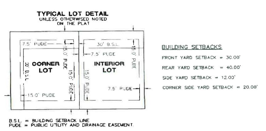
(18) Building setback lines accurately shown with dimensions; they shall be in compliance with Chapter 156 of this code as set forth for the district in which the property is located. A Typical Lot Detail diagram shall be included on the plat. This shall include details on building setback lines, public utility and drainage easements for a typical interior lot and a typical corner lot. For subdivision developments with multiple housing types, the same details must be provided for lots of each type. An example of this notation is below;
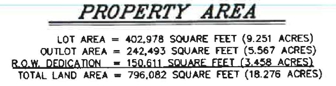
(19) The total area of the plat computed in acres; including notes on lot area, outlot area, right-of-way dedication, and open space. An example of this notation below;
(20) House numbers shall be designated on each lot. In order to prevent confusion in the permitting process, multi-unit structures shall identify and assign a house number for each specific unit on the plat, rather than simply providing a list of addresses;
(21) The following information relating to the position and location of the subdivision shall be shown on the plat:
(a) The location of the subdivision by government lot, section, township, range, and county;
(b) The exact location of the subdivision indicated by distances and bearings with reference to a corner or corners of a section or half section; in case any subdivision crosses any section, quarter section, or quarter section lines, or is adjacent to any of these lines, all section, quarter section, or quarter section corners in or adjacent to the subdivision shall be marked and referenced with monuments; and
(c) The area designated for septic field location including move-over location in conformance with requirements of the Lake County Health Department or designated jurisdictional authority.
(22) A copy of the secondary plat shall be provided digitally as specified by the Planning Administrator in AutoCad or equivalent format and PDF format.
(23) Information on anti-monotony rules shall be included on the plat unless it has been determined by the Plan Commission that they are not applicable in the subdivision or development.
(Ord. 27, § 7.10.40, passed 4-16-1997; Am. Ord. 210, passed 9-11-2012; Am. Ord. 210-C, passed 12-8-2020)