(A) For the purpose of this section, the following definitions shall apply unless the context clearly indicates or requires a different meaning.
COUNCIL. The Town Council of the Town of Walkerton, St. Joseph County, Indiana.
TOWN. The Town of Walkerton, St. Joseph County, Indiana.
(2005 Code, § 12.01)
(B) The Town Council consists of five members.
(2005 Code, § 12.02)
(C) The members of the Town Council shall be elected both by ward and at large by the voters of the whole Town in accordance with I.C. 36-5-2-5.
(2005 Code, § 12.03)
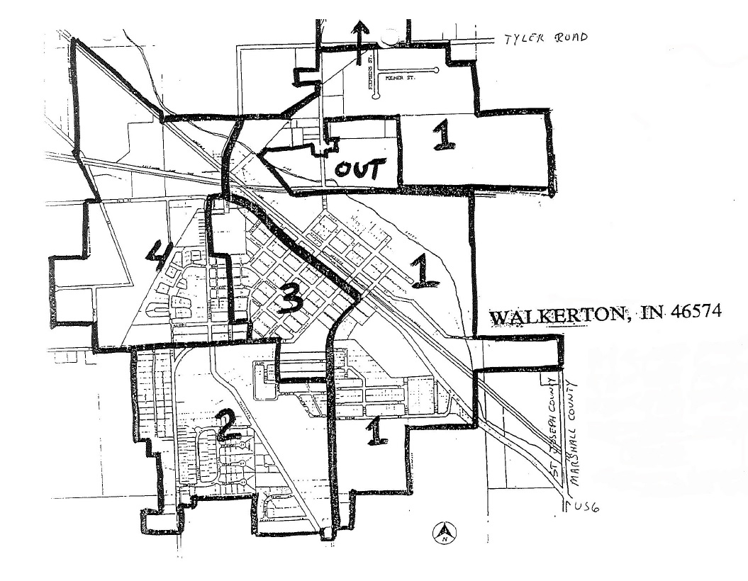
(D) The Town Council divides the Town into the following wards for the purpose of conducting elections of Town Council members:
(1) Ward 1. Beginning at the north Town limits and Adams Street; thence south on Adams Street to Roosevelt Road; thence southeast on Roosevelt Road to Georgia Street; thence southwest and south on Georgia Street to the south Town limits; thence east north and west along Town limits to Adams Street and the point of beginning;
(2) Ward 2. Beginning at the west Town limits and Virginia Street; thence east on Virginia Street to Maine Street; thence south on Maine Street to Shamrock Street; thence east on Shamrock Street to Georgia Street; thence south on Georgia Street to the south Town limits; thence west and north along Town limits to Virginia Street and the point of beginning;
(3) Ward 3. Beginning at the intersection of Washington Street and Roosevelt Road; thence southeast on Roosevelt Road to Georgia Street; thence southwest and south on Georgia Street to Shamrock Street; thence west on Shamrock Street to Maine Street; thence north on Maine Street to Virginia Street; thence west on Virginia Street to Jefferson Street; thence north on Jefferson Street to Illinois Street; thence west on Illinois Street to Adams Street; thence north on Adams Street to the first east-west alley north of Ohio Street (also known as Park Drive); thence west on said alley to Washington Street; thence north on Washington Street to Roosevelt Road and the point of beginning;
(4) Ward 4. Beginning at the north Town limits and Adams Street; thence south on Adams Street to Roosevelt Road; thence west on Roosevelt Road to Washington Street; thence south on Washington Street to the first east-west alley north of Ohio Street (also knows as Park Drive); thence east on said alley to Adams Street; thence south on Adams Street to Illinois Street; thence east on Illinois Street to Jefferson Street; thence south on Jefferson Street to Virginia Street; thence west on Virginia Street to the west Town limits; thence north and east along Town limits to Adams Street and the point of beginning; and
(5) Ward 5. All of the Town falling within the Town limits. (Town Council member shall be deemed to be at large.)
(2005 Code, § 12.04)
(E) If any part of the Town is not included in one of the wards established by this section, that territory is included within the ward that:
(1) Is contiguous to that territory; and
(2) Contains the smallest population (as “population” is defined in I.C. 1-1-4-5).
(2005 Code, § 12.05)
(F) If any part of the Town is included in more than one of the wards established by this section, that territory is included within the ward that:
(1) Is one of the wards in which territory is described in this section;
(2) Is contiguous to that territory; and
(3) Contains the smallest population (as “population” is defined in I.C. 1-1-4-6).
(2005 Code, § 12.06)
(G) (1) The Town Council adopts a map depicting the wards established under this section, and the map is set out below.
(2) Two copies of this map are on files in the office of the Clerk-Treasurer for public inspection as required by I.C. 36-1-5-4.
(3) If a conflict exists between the wards as depicted on the map and as described in this section, the description in this section prevails.
(2005 Code, § 12.07)
(H) (1) Ward 1. Beginning at the north Town limits and Adams Street; thence south on Adams Street to Roosevelt Road; thence southeast on Roosevelt Road to Georgia Street; thence southwest and south on Georgia Street to the south Town limits; thence east north and west along Town limits to Adams Street and the point of beginning;
(2) Ward 2. Beginning at the west Town limits and Virginia Street; thence east on Virginia Street to Maine Street; thence south on Maine Street to Shamrock Street, thence east on Shamrock Street to Georgia Street; thence south on Georgia Street to the south Town limits; thence west and north along Town limits to Virginia Street and the point of beginning;
(3) Ward 3. Beginning at the intersection of Washington Street and Roosevelt Road; thence southeast on Roosevelt Road to Georgia Street; thence southwest and south on Georgia Street to Shamrock Street; thence west on Shamrock Street to Maine Street; thence north on Maine Street to Virginia Street; thence west on Virginia Street to Jefferson Street; thence north on Jefferson Street to Illinois Street; thence west on Illinois Street to Adams Street; thence north on Adams Street to the first east-west alley north of Ohio Street (also known as Park Drive); thence west on said alley to Washington Street; thence north on Washington Street to Roosevelt Road and the point of beginning; and
(4) Ward 4. Beginning at the north Town limits and Adams Street; thence south on Adams Street to Roosevelt Road; thence west on Roosevelt Road to Washington Street; thence south on Washington Street to the first east-west alley north of Ohio Street (also known as Park Drive); thence east on said alley to Adams Street; thence south on Adams Street to Illinois Street; thence east on Illinois Street to Jefferson Street; thence south on Jefferson Street to Virginia Street; thence west on Virginia Street to the west Town limits; thence north and east along Town limits to Adams Street and the point of beginning.
(2005 Code, § 12.08)
(Ord. passed 12- -1982; Ord. 2002-08, passed 9-3-2002)