A. Access:
1. Access To Existing Roads: All points of access to existing public roads or highways shall meet the standards set forth in "A Policy Of Geometric Design Of Highways And Streets", 1990, as published by the American Association of State Highway and Transportation Officials (AASHTO), which is hereby incorporated by reference as if set forth in its entirety herein; and subsections A through D of this section or, in the case of state highways, as approved by the state department of transportation. The design and construction of turn lanes, merging lanes, traffic signs or signals and other improvements required to make access points conform to county or UDOT standards shall be the responsibility of the developer.
2. Number Required: A minimum of two (2) access roads for separate ingress and egress will be provided. At least one access road will be considered the main access to be dedicated with a right of way easement as part of the final plat. In situations where dual access is not available within the initial development, one or more easements extending to the perimeter of the proposed development and evidence that existing vehicular access through adjacent properties to public roads must be provided by the developer. At a minimum, the second access, which may not comply with this section, may be permitted, so long as it is a passable access road and maintained for emergency services as approved by the PCFSD.
3. Spacing: Except as otherwise provided herein, access drives shall be spaced according to the following table:
Road Classification
| Minimum Spacing
| Minimum Distance From Intersection |
Local | 35 feet apart | 50 feet |
Collector | 50 feet apart | 75 feet |
Arterials | Access points shall be minimized |
B. Intersections:
1. Grade: The grade within one hundred feet (100') of any intersection shall not exceed three percent (3%).
2. Hazards: Intersections shall not create hazardous driving conditions. The site design shall avoid curves in the roadway and the crests of hills at intersection locations.
3. Alignment: Roadways shall be within ten percent (10%) of a perpendicular alignment within one hundred feet (100') of any intersection, unless otherwise approved by the county manager.
4. Intersection Offsets/Spacing: Intersection offsets shall be based upon the roadway classification, and shall be measured as follows unless otherwise approved by the county manager:
Road Classification
| Offset
|
Local | 125 feet |
Collector | 330 feet |
Arterials | 600 feet |
C. Road Grades:
1. The maximum grade of all roads, with the following exceptions, shall be eight percent (8%). Rural collector, rural local, and rural minor roads shall require grades of ten percent (10%) or less. However, these rural roads may contain grades in excess of ten percent (10%), up to a maximum of twelve and one-half percent (12.5%) for short distances only when, at the discretion of the county, it is determined that the steeper road grade is in the best interest of the county for purposes of environmental protection and it is further determined that the steeper grade will not adversely affect public safety. Roads having grades in excess of eight percent (8%) shall be privately owned and maintained.
a. "Short distances" are measured along roadway centerline and are defined as less than or equal to five hundred feet (500') over a continual distance of one thousand feet (1,000').
b. Main through roads (nonstop sign roads) can remain at a constant grade of less than eight percent (8%) through the intersection.
c. Retaining walls shall be used when cuts or fills exceed ten feet (10') as measured vertically at the edge of the road shoulder. Cut and fill slopes shall be as specified by a qualified engineer to achieve a stable embankment. Cut and fill areas shall be contoured to two feet (2') horizontal to one foot (1') vertical slopes or flatter unless stability at a steeper slope is determined by a qualified engineer.
2. In all instances, the minimum road grade shall be 0.3 percent.
3. The following conditions shall be used for grades in excess of ten percent (10%); provided, that all applicable emergency and service providers review, at time of subdivision plat and site plan review, such road design and grades to adequately address the public health, safety and welfare:
a. Revegetation of all disturbed soils meeting county construction standards will be required on all roads.
D. Road Infrastructure Design:
1. The design and construction of all roads in the Snyderville Basin shall be in accordance with the specifications adopted by the county, the American Association of State Highway and Transportation Officials ("A Policy Of Geometric Design Of Highways And Streets"), and those set forth herein.
2. Roads on soils having low bearing strengths, high shrink/swell potentials or high frost heave hazards may be required, upon recommendation of the county engineer, to be constructed to specifications more demanding than those required on others. All roads and driveways will have unobstructed vertical clearance of thirteen feet six inches (13'6").
3. Homeowners may not grant additional vehicular rights of way and road easements across their property in addition to those vehicular rights of way and road easements that are already of record at the date of the plat recordation.
4. In town and resort centers, public roads shall generally meet the following design guideline. The county engineer may require adjustments in this guideline based on site specific conditions and development characteristics.
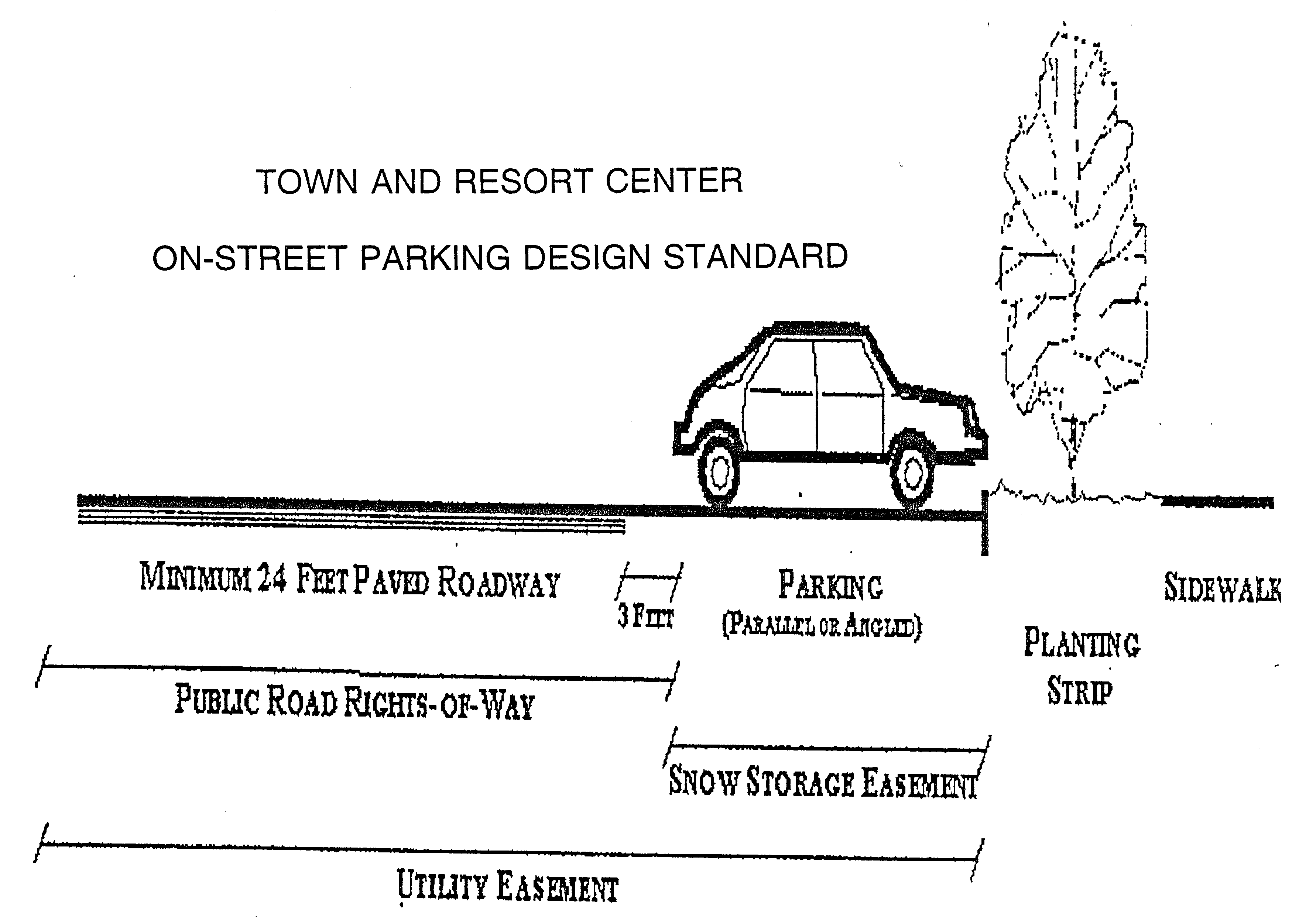
TABLE 1 RURAL ROAD DESIGN STANDARDS FOR DEVELOPMENT WITH LOT SIZES OF 5 ACRES OR MORE
Rural Collector | Rural Local | Rural Minor |
Rural Collector | Rural Local | Rural Minor | |
Function | Provides a primary access to and through development from other arterial or collectors and is intended to serve as a primary trafficway | Provides supplemental access to adjoining properties and is secondary to a rural collector; provides limited continuity | Provides supplemental access to adjoining properties and is secondary to a rural local road; provides little continuity |
Rights of way | 50 feet | 50 feet | 50 feet |
Pavement width | 24 feet | 20 - 24 feet | 18 - 20 feet |
Shoulder width | 2 - 4 feet | 2 feet | 2 feet |
Drainage | Open swale or ditch | Open swale or ditch | Open swale or ditch |
Design speed | 40 mph | 25 mph | 20 mph |
The minimum width of a road surface that will be considered for a public dedication is 24 feet. | |||
The minimum width of a road right of way that will be considered for public dedication shall be 60 feet. | |||
All dimensions noted above represent minimum standards. Required dimensions may be greater depending on specific conditions. | |||
TABLE 2 MODERATE DENSITY ROAD DESIGN STANDARDS FOR DEVELOPMENT WITH LOT SIZES LESS THAN 5 ACRES, DEPENDING ON DEVELOPMENT INTENSITY, AT THE DISCRETION OF THE COUNTY
Arterial | Collector | Residential Street |
Arterial | Collector | Residential Street | |
Function | Traffic movement with limited access for adjacent uses | Traffic movement with limited access for adjacent uses | Access to adjacent moderate to high density uses |
Rights of way | 60 - 120 feet | 50 - 60 feet | 50 - 60 feet |
Pavement width | 24 - 60 feet | 24 - 32 feet | 20 - 24 feet |
Shoulder width | n/a | n/a | n/a |
Drainage | Curb/gutter or open swale or ditch depending on development intensity | Curb/gutter or open swale or ditch depending on development intensity | Curb/gutter or open swale or ditch depending on development intensity |
Sidewalks | Possibly, depending on development intensity | Possibly, depending on development intensity | Possibly, depending on development intensity |
Parking lanes | No | Not required | Possibly, depending on development intensity |
Design speed | 45 mph | 35 mph | 25 mph |
The minimum width of a road surface that will be considered for public dedication is 24 feet. | |||
All dimensions noted above represent minimum standards. Required dimensions may be greater depending on specific conditions. | |||
TABLE 3 TOWN AND RESORT CENTER ROAD DESIGN STANDARDS
Arterial | Collector | Commercial Street | Residential Street | Road | Alley |
Arterial | Collector | Commercial Street | Residential Street | Road | Alley | |
Function | Traffic movement with limited access for adjacent uses | Traffic movement with limited access for adjacent uses | Access to adjacent high density uses | Access to adjacent moderate to high density uses | Access to adjacent low density uses | Access to adjacent uses; not intended for traffic movement |
Rights of way | 60 - 120 feet | 50 - 60 feet | 65 - 96 feet | 42 - 60 feet | 44 - 48 feet | 12 - 20 feet |
Pavement width | 24 - 60 feet | 24 - 44 feet | 20 - 36 feet | 20 - 24 feet | 20 - 24 feet | 12 - 20 feet |
Shoulder width | Per AASHTO | Per AASHTO | Per AASHTO | Per AASHTO | 2 feet | Per AASHTO |
Drainage | Curb/gutter or open swale or ditch depending on development intensity | Curb/gutter or open swale or ditch depending on development intensity | Curb/gutter | Curb/gutter | Curb/gutter or open swale or ditch depending on development intensity | n/a |
Sidewalks | Required | Required | Required | Required | Required | n/a |
Parking lanes | No | Possibly | Yes | Yes | Possibly | No |
Design speed | 45 mph | 35 mph | 25 mph | 25 mph | 25 mph | 15 mph |
The minimum width of a road surface that will be considered for public dedication is 24 feet. | ||||||
All dimensions noted above represent minimum standards. Required dimensions may be greater depending on specific conditions. | ||||||
AASHTO = American Association of State and Highway Transportation Officials. | ||||||
E. Driveway Access:
1. All individual driveway access locations shall be designed to function well with the existing conditions and layout of each residential building. Care shall be taken in locating driveways to allow for the least amount of site and vegetation disturbance. The maximum grade of any driveway shall not exceed ten percent (10%). The minimum width of any driveway shall be twelve feet (12'). Twelve percent (12%) grades may be allowed for short distances not to exceed two hundred fifty feet (250') when approved by PCFSD. Where possible, driveways shall parallel the slope to lessen site impact. Driveways must also conform to the requirements of title 7, chapter 1 of this code.
2. A driveway may provide access to one or more dwelling units, but not more than five (5) dwellings. Driveways serving three (3) or more dwellings must be a minimum of twenty feet (20') in width.
3. Retaining walls shall be used with cuts in excess of ten feet (10'). Cut slopes shall be as specified by a qualified engineer to achieve a stable embankment. Fill areas shall be contoured to two feet (2') horizontal to one foot (1') vertical slopes or flatter as directed by a qualified engineer. If the disturbed areas fail to match existing grade within ten (10) vertical feet, a retaining wall shall be used. Driveway access for all lots may not be from any street or road other than interior roads within the subdivision.
4. All driveways, whether or not locked, must provide a PCFSD approved turnaround for emergency vehicles where the driveway meets the building pad, and every two hundred feet (200') when longer driveways occur.
5. Driveways in excess of two hundred feet (200') and less than twenty feet (20') wide must be provided with turnouts. Driveway turnouts must be an all weather road surface, ten feet (10') wide and thirty feet (30') long. Driveway turnouts to be located as required by PCFSD.
F. Cul-De-Sacs:
1. The maximum length of a cul-de-sac on any nonrural designated road, as defined in subsection D of this section, shall be six hundred feet (600').
2. The maximum length of a cul-de-sac on a rural designated road, as defined in subsection D of this section, shall be as follows, unless other lengths are agreed to by PCFSD. The length of these cul-de-sacs shall be based on the wildfire hazard rating of the surrounding area.
Wildfire Hazard Rating
| Maximum Length
|
Moderate | 1,200 feet |
High | 900 feet |
Extreme | 500 feet |
3. The cul-de-sac shall not be less than sixty feet (60') in diameter, or as required by the Park City fire service district and county engineer. Public roads having a cul-de-sac shall not be less than ninety feet (90') in diameter, unless otherwise approved by the county manager.
4. A hammerhead cul-de-sac design may be allowed in certain instances.
5. All cul-de-sacs must include signage indicating that the road is a dead end road within fifty feet (50') of the outlet. In addition, two (2) signs will be placed on the connecting road indicating that the "next turn is a dead end road".
6. Project designs including cul-de-sacs within developments where local roads are dedicated for public maintenance are discouraged.
G Road Base Specifications:
1. All roads shall be designed by a qualified engineer. A geotechnical report supporting pavement design shall be required.
2. All roads shall have a base capable of supporting a gross vehicle weight of at least forty thousand (40,000) pounds. The county engineer may require additional support base depending on the specific function and traffic volumes anticipated on the roadway.
3. All roads shall include compacted road base, covered with either concrete or asphalt material, with the exception of emergency access roads, which may be compacted gravel or road base. Roads must meet all applicable county design standards. (Ord. 708, 12-10-2008)
4. All road surfaces must be capable of providing all weather, year round access, with the exception of emergency access roads in mountain remote areas and areas that contain critical lands, where emergency access roads must provide only summer access.
H. Bridges And Culverts: Bridges and culverts shall be constructed to support a gross vehicle weight of forty thousand (40,000) pounds; vehicle load limits will be posted. Permanent culverts shall be installed at all intermittent and perennial stream crossings. Specifications for bridges, culverts and other stream crossing devices shall take into account at least the 25-year frequency storm and upstream debris hazard. If the development is within the 100-year floodplain, then 100-year frequency storm shall be used in drainage design. Bridges and culverts shall be reviewed by the CDD or designated planning staff member. Bridges and culverts deemed to be visible from a public roadway shall include materials such as natural stone, wood, or steel. (Ord. 818, 2-26-2014)
I. Traffic Control And Street Signage:
1. All roads will be designated with road names, and signs will be installed at each major road intersection. All lots and/or homesites will be visibly signed with street addresses and numbered as such or at the beginning of the driveway. Emergency access road shall be clearly identified.
2. All roads shall be named or numbered in accord with the county's addressing system and road identification signs in accordance with county standards and specifications. All permitted structures for residential, commercial and industrial uses shall post addresses prior to occupancy.
3. A developer shall be responsible for the expense of constructing and placing traffic control signs, as follows:
a. Stop signs shall be placed at all intersections of arterials; of collectors and arterials; and when appropriate, as determined by the county engineer, local streets/roads and collectors.
b. Yield signs shall be required at the intersection of all other streets and roads when determined appropriate by the county engineer.
J. Road Maintenance:
1. Snow Removal And Road Maintenance: Snow removal and road maintenance on private roads will be the responsibility of the respective homeowners' association and/or homeowners and will be noted as such on the recorded plat.
2. Maintenance Cost: Roads intended to be owned and maintained by the county will not be accepted by the county for such purposes until adequate tax revenues accrue to the county from the development to pay the cost of all related road maintenance services for the roadway, in addition to other applicable county services for the development, or unless the county determines that there are compelling reasons to accept responsibility for the road in the absence of adequate tax revenues. Road maintenance and snow removal services shall be provided in accordance with the appropriate county ordinances.
K. Level Of Service Standards:
1. No development application may be approved which causes a reduction in the level of service for any road below the adopted level of service as set forth in this title and the general plan, as such may be amended from time to time.
2. The operational character that shall be maintained for roadways and intersections in the Snyderville Basin shall be a level of service C for county roads and intersections and a level of service D for state roads. "Level of service" is as defined by the transportation research board, highway capacity manual (special report 209, 1985).
3. The applicant shall make an offer of dedication of any rights of way which are within but will not serve a development, and which are necessary to effectively link the proposed development with future major roads or future developments, or to prevent the "landlocking" of adjoining properties or to provide the best possible long term circulation pattern prior to approval of a final subdivision plat or final site plan.
4. The dedication of the wider rights of way necessary to facilitate road improvements called for in the county transportation plan in response to a request from the county council or commission, is required.
L. Sidewalks:
1. Sidewalks, pedestrian walkways or nonmotorized trails necessary (as recommended by the county engineer) for adequate internal circulation within a development shall be provided. Sidewalks shall be provided in appropriate locations as specified in tables 1 through 3 of this section.
2. Sidewalks, walkways and trails shall be designed and constructed to the specifications provided by the county engineer. (Ord. 708, 12-10-2008)