(A) Intention of definitions. These definitions are intended to provide specific meanings for words and terms commonly used in zoning and land use regulations.
(B) Meaning of words, generally. All words and terms used in this chapter have their commonly accepted, dictionary meaning unless they are specifically defined in this chapter or the context in which they are used clearly indicated to the contrary.
(C) Meaning of common words.
(1) All words used in the plural include the singular, and all words used in the singular include the plural unless the context clearly indicates to the contrary.
(2) The word "shall" is mandatory and the word "may" is permissive.
(3) The word "building" includes the word "structure".
(4) The phrase "used for" includes the phrases "arranged for", "designed for", "intended for", "maintained for", and "occupied for".
(5) The word "land" and "property" are used interchangeably unless the context clearly indicates to the contrary.
(6) The word "person" may be taken for persons, associations, firms, partnerships or corporations.
(D) Meaning of specific words and terms. The listed specific words and terms are defined as follows:
ABUTTING LOTS. Two or more lots joined by a common boundary line or point. For the purposes of this definition, no boundary line shall be deemed interrupted by a road, street, alley or public way, it being the intent of this definition to treat property lying on the opposite sides of a road, street, alley or public way as having a common boundary line or point.
ACCESS. A pedestrian, bicycle, or motor vehicular entrance to a property.
ALLEY. A public or private way permanently reserved as a means of access to abutting property, usually with principal access from another street.
ARTERIAL. See STREET.
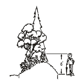
BERM. An earthen mound designed to provide a visual interest, screen undesirable views, and/or decrease noise.
BLOCK. A tract of land bounded by street or by a combination of streets and public parks, cemeteries, railroad rights-of-way, drainageways, or unsubdivided land.
BOARDING, LODGING OR ROOMING HOUSE. An establishment with lodging for not less than five persons nor more than ten persons not including members of the owner-occupant or tenant-occupant family, other than a hotel or motel, where lodging, with or without meals, is provided.
BOND. Any form of security (including a cash deposit, surety bond, collateral, property, or instrument of credit) in an amount and form satisfactory to the city.
BREEZEWAY. A structure for the principal purpose of connecting the main building or buildings on a property with other main buildings or accessory buildings.
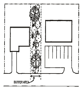
BUFFER. A combination of physical space and vertical elements, such as plants, berms, fences or walls, designed to provide space or distance, obstruct undesirable views, serve as an acoustic barrier, generally reduce impacts of adjacent development, or separate and screen incompatible land uses from each other.
BUILDING. Any structure used or intended for support, shelter or enclosure of any persons, animals, goods, equipment or chattels and property of any kind.
BUILDING HEIGHT. See HEIGHT OF BUILDINGS definition.
BUILDING LINE. A line on a plat indicating the limit beyond which buildings or structures may not be erected, or the minimum distance as prescribed by this chapter between the property line abutting a street and the closest point of the foundation of any building or structure related thereto. BUILDING LINE means a line established by this title to govern the placement of a building with respect to the front lot line through the setback requirements of a minimum front yard. A BUILDING LINE is ordinarily parallel to the front lot line and at a distance in accordance with the setback requirement.
BUILDING TYPES.
(a) NONRESIDENTIAL. That group of building types comprising the following:
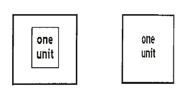
1. DETACHED. A single main building, freestanding and structurally separated from other buildings.
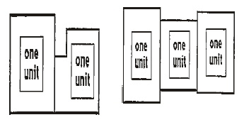
2. ATTACHED. Two or more main buildings placed side by side so that some structural parts are touching one another.
(b) RESIDENTIAL. That group of building types comprising the following:
1. SINGLE DETACHED. One dwelling unit, freestanding and structurally separated from any other dwelling unit or buildings, located on a lot or development site, including manufactured homes as defined in this chapter.
2. DUPLEX. Two dwelling units located on a single lot or development site.
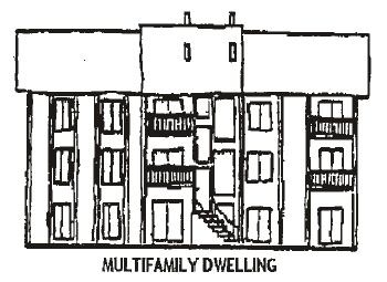
3. MULTI-FAMILY DWELLING. At least three dwelling units in any vertical or horizontal arrangement, located on a lot or development site. An existing dwelling may be utilized as part of a multi-family dwelling when redevelopment of the site occurs and does not have to be attached to another structure.
4. MANUFACTURED DWELLING PARK. A place where four or more manufactured or mobile homes are located within 500 feet of one another on a lot, tract, or parcel of land under the same ownership, the primary purpose of which is to rent or keep space for rent or to offer space free in connection with securing the trade or patronage of such person.
CITY. The City of Shady Cove.
CITY ENGINEER. Any engineer registered with the state who is employed or designated by the city to perform the function or functions described in the context of this chapter. The engineer may be employed or designated either generally or with respect to a particular matter or matters.
COLLECTOR. A street supplementary to Highway 62 used for through traffic and access to abutting properties.
CORNER CLEARANCE. The distance from an intersection of a public or private road to the nearest access connection, measured from the closest edge of the pavement of the connection along the traveled way.
COMPREHENSIVE PLAN. The comprehensive development plan for the city, comprising plans, maps or reports, or any combination thereof relating to the future economic and physical growth and development or redevelopment of the city.
CUL-DE-SAC. A local street with only one outlet and have at turn-around at the opposite end.
DEFERRED IMPROVEMENT AGREEMENT. An agreement between the city and subdivider or land partitioner for future improvement of a street or streets if and when the city determines it is time to improve the street to city standards. The cost upon completion will be assessed to the abutting property owners in just proportion to the benefit received.
DENSITY, GROSS. The number of residential dwelling units per gross acre of land.
DENSITY, NET. The number of dwelling units per net acre (based on the total area of the parcel) excluding areas dedicated for public use.
DETENTION, STORMWATER. A detention facility that temporarily stores stormwater runoff and subsequently releases it at a slower rate than would otherwise occur.
DEVELOPER. The owner of property, agent or contractor, successor or assign, who has undertaken or is proposing development.
DISTRICT. A portion of the total area within the boundaries of the city within which specific sections of these regulations apply. For example, the R-1, Single-family Residential District.
EASEMENT. A right that a person has to use someone's land for a specific purpose such as access or utilities.
EFFECTS OF BUOYANCY. Uplift force of water on a submerged or partially submerged object.
EROSION. Detachment and movement of soil, rock fragments, refuse, or any other material, organic or inorganic.
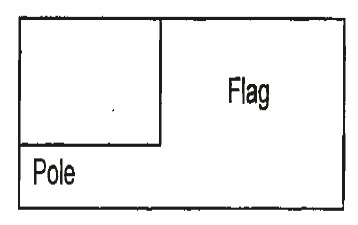
FLAG LOT. A lot that has access to a public right-of-way by means of a narrow strip of land.
FLOOD, SLOPE AND HAZARD AREAS.
(a) BUILDABLE AREAS. Accessible lands of less than 15% slope that lie outside the 100-year floodplain and outside water quality setback areas.
(b) CONSTRAINED AREAS Accessible lands of 15%-24.9% slope outside the 100-year floodplain and outside water quality setback areas.
(c) UNBUILDABLE AREAS. Floodway areas, steeply sloped land (that is 25% slope or greater), associated wetlands, and land within riparian corridor boundaries and water quality setback areas.
FLOODPLAIN Any land susceptible to being inundated by water from any source. The base flood area as defined on the Flood Insurance Rate Map is the 100-year floodplain. See also ASSOCIATED WETLAND or SLOPED AREA.
FLOODWAY. The channel of a river or stream and adjacent land areas that must be reserved exclusively to discharge the waters of a base flood.
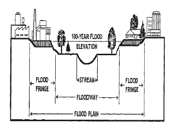
FRONTAGE. That portion of a development site that abuts a public or private street.
GRADE. The lowest point of elevation of the finished surface of the ground, paving or sidewalk within the area between the building and the property line, or, when the property line is more than five feet from the building, between the building and a line five feet from the building.
HAZARD AREAS. See FLOOD, SLOPE, AND HAZARD AREAS.
HOME BUSINESS. A lawful commercial activity commonly carried on within a dwelling or attached or detached accessory structure.
LAND AREA, NET. That land area remaining after all area covered by impervious surfaces has been excluded (subtracted).
LAND DIVISION. Land divided to create legally separate parcels in one of the following ways:
(a) PARTITION. A division of land that creates three or fewer lots within a calendar year when such parcel exists as a unit or contiguous units of land under single ownership at the beginning of the year. See also, REPLAT, MINOR.
(b) A partition includes:
1. MAJOR PARTITION. A partition which includes the creation of a street.
2. MINOR PARTITION. A partition that does not include the creation of a street.
3. SERIES PARTITION. A series of partitions resulting in the creation of four or more parcels over a period of more than one calendar year and composed of a series of major partitions or minor partitions, or a series combining both major and minor partitions.
(c) A partition does not include division of land resulting from any of the following:
1. Establishment or modifications of a "tax lot" by the County Assessor;
2. A lien foreclosure, foreclosure of a recorded contract for the sale of real property or creation of cemetery lots;
3. An adjustment of a property line by relocation of a common boundary where an additional unit of land is not created and where the existing unit of land reduced in size by the adjustment complies with any applicable development district criteria established by ordinance;
4. Sale or grant by a person to a pubic agency or public body for state highway, county road, city street or other right-of-way purposes provided that such road or right-of-way complies with the applicable comprehensive plan policies.
(d) SUBDIVISION. Division of an area or tract of land into four or more lots within a calendar year when such area or tract of land exists as a unit or contiguous units of land under a single ownership at the beginning of such year.
LOT LINE. The property line bounding a lot.
LOT LINE, FRONT. In the case of an interior lot, a property line that abuts the street. In the case of a corner lot, the front line shall be determined by orientation of the structure based on at least two of the following factors: location of the front door, location of the driveway, or legal street address.
LOT LINE, REAR. A lot line that is not abutting a public street and which is opposite the front lot line of the lot. In the case of a triangular or otherwise irregularly shaped lot, the REAR LOT LINE shall be a line ten feet in length within the lot and parallel to and at a maximum distance from the front lot line.
(a) Is parallel to the front lot line or its chord and,
(b) Intersects the other lot lines at points most distant from the front line (see figure below).
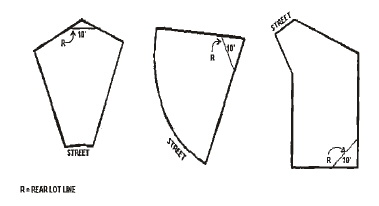
LOT LINE, SIDE. Any lot boundary not a front or rear lot line (see figure under LOT LINE, REAR).
LOT, REVERSED CORNER. A corner lot whose rear line borders the side yard of another lot, whether or not separated by an alley.
LOT, THROUGH. A lot of record whose front and rear lot lines both abut streets.
LOT WIDTH. The horizontal distance between the midpoints of the side lot lines.
NUISANCE. Activity or use that is annoying, unpleasant or obnoxious.
OWNER. The owner of record of real property as shown on the latest tax rolls of Jackson County, or by the deed records of such county, or a person who is purchasing property under contract. In terms of violations and binding agreements between the city and owner, the OWNER shall also mean leaseholder, tenant, or other person in possession or control of the premises or property at the time of agreement or of violation of agreement or the provisions of this chapter. OWNER shall also mean authorized representative.
PARCEL. A unit of land created by partitioning of land.
PERSON. An individual, firm, partnership, association, social or fraternal organization, trust, estate, receiver, syndicate, branch of government, or any group or combination acting as a unit.
PLANNED DEVELOPMENT. A land development project comprehensively planned as an entity via a unified site plan that permits flexibility in building siting, mixtures of building types and land uses, useable open spaces, and the preservation of significant natural features. PLANNED DEVELOPMENT means the proposed land development project as finally approved by the Planning Commission, and shall include a plat, all covenants, grants of easement, and other conditions relating to use, location and bulk of building, density of development, common open space and public facilities. The plan shall include such information as required by this zoning title.
PLANNING COMMISSION. The Planning Commission of the City of Shady Cove, Oregon.
PLAT. Refers to a final subdivision plat, replat or partition plat.
PLAT, PARTITION. A final map, diagram, drawing, replat, or other writing containing all the descriptions, locations, specifications, provisions and information concerning a partition.
PLAT, SUBDIVISION. A final map, diagram, drawing, replat, or other writing containing all the descriptions, locations, specifications, dedications, provisions, and information concerning a subdivision.
PROPERTY LINE ADJUSTMENT. The relocation of a common property boundary where an additional unit of land is not created and where an existing unit of land reduced in size by the adjustment complies with any applicable development district regulation.
PUBLIC FACILITY.
(a) Public facilities include, but are not limited to, sanitary sewer, water, storm drainage, street, communication, electrical and natural gas facilities necessary to support development.
(b) There are two types of public facilities:
1. PUBLIC FACILITY, MAJOR. Any public service improvement or structure developed by or for a public agency that is not defined as a minor public facility, including but not limited to electrical substations, sewer and water treatment plants, water reservoirs, trunk lines, regional stormwater detention facilities, new or expanded public buildings designed for human occupancy that increase traffic within a neighborhood, and active park improvements such as ball fields or restroom facilities.
2. PUBLIC FACILITY, MINOR. Minor utility structures (e.g., poles, lines, pipes); minor sewer, water and storm drainage structures and collection system improvements (e.g., pump stations, lines, manholes, valves, hydrants, drains, on-site detention facilities); new or extended public streets (including lane additions), minor improvements to existing streets (e.g., overlays, catch basins, signs, control devices, widening, curbs, gutter, sidewalks); minor transit improvements (e.g., bus stops or shelters); passive park improvements (e.g., trails, benches, native plantings or picnic areas).
REPLAT, MAJOR. The reconfiguring of lots in a recorded subdivision plat that results in either the creation of four or more additional lots, deletion of four or more lots, or reconfiguring of four or more lots.
REPLAT, MINOR. The reconfiguring of lots in a recorded subdivision plat that results in either the creation of four or fewer lots, deletion of three or fewer lots, or reconfiguring of three or fewer lots.
SETBACK. The minimum allowable horizontal distance from a given point or line of reference, which for purposes of this chapter shall be the property line, to the nearest vertical wall of a building or structure, fence, or other elements as defined by this chapter.
SITE. The property subject to a development permit or erosion control plan.
SITE PLAN. A plan, prepared to scale, showing accurately and with complete dimensioning, the boundaries of a site and the location of all buildings, structures, uses, and principal site development features proposed for a specific parcel of land.
SLOPE. See FLOOD, SLOPE, AND HAZARD AREAS.
STREAM. A channel such as a river or creek that carries, flowing surface water, including perennial streams and intermittent streams with defined channels, and excluding man-made irrigation and drainage channels.
STREET. A public or private way that is created to provide ingress or egress for persons to one or more lots, parcels, areas or tracts of land and including the terms road, highway, lane, avenue, alley or similar designation.
ARTERIAL HIGHWAYS. Highway 62, which carries a majority of vehicle trips entering, leaving, or passing through the Shady Cove area.
COLLECTOR STREETS. These provide both access and circulation within residential neighborhoods and commercial are.
CUL-DE-SAC (DEAD END STREET). A local street having one end open to traffic and being terminated by a vehicle turnaround.
LOCAL STREETS. The primary function is to provide access to immediately adjacent land.
STUB STREETS. A portion of a street or cross access drive uses as an extension to an abutting property that may be developed in the future.
SUBDIVISION. See LAND DIVISION.
UNBUILDABLE AREAS. Floodway areas, steeply sloped land (25% slope or greater), associated wetlands, and land within riparian corridor boundaries and water quality setback areas.
VARIANCE, AREA. A dispensation permitted on individual parcels of property as a method of alleviating unnecessary hardship by allowing a deviation from dimensional (i.e., height, bulk, yard, setbacks) requirements of the Zoning Ordinance because of unusual or unique conditions.
WETLAND. Wetlands generally include, but are not limited to, swamps, marshes, bogs, and similar wet areas. WETLANDS are areas inundated or saturated by surface water or groundwater at a frequency and duration sufficient to support a prevalence of hydrophytic vegetation. Hydrophytic vegetation typically is adapted for life in saturated soils, and under normal circumstances would be found in wetlands.
WETLAND OR SLOPED AREA. Refers to a wetland or sloped area that overlaps with or is adjacent to a stream corridor, natural drainage way or floodplain.
ZONING DISTRICT. An area of land within the Shady Cove city limits, designated for specific types of permitted developments, subject to the development requirements of that district.
(Ord. 224, passed 12-2-2004)