The following terms are defined for use in the Zoning Code.
1. Abandonment" means the act of intentionally and permanently giving up, surrendering, deserting or relinquishing property, premises, a right of way, contract rights, a vehicle or animal.
2. "Abut or Abutting" means making contact with or separated only by public right-of-way, railroad or other public utility, the condition of two adjoining properties having a common property line or boundary.
3. "Access" or "access way" means the place, means, or way by which pedestrians and vehicles shall have safe, adequate, and usable ingress and egress to a property or use as required by this Zoning Code.
4. Accessory living quarters" means living quarters within an accessory building located on the same premises with the main building, for use by temporary guests of the occupant of the premises, such quarters having no kitchen facilities and not rented or otherwise used as a separate dwelling unit.
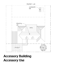
5. "Accessory building or structure" means a detached subordinate building or structure located on the same lot with the principal building or structure, the use of which is incidental and accessory to that of the principal structure. Customary accessory buildings and structures include farm buildings, garages, carports, and storage sheds but not portable storage containers.
6. "Accessory dwelling unit" means an in-law or mother-in-law unit, secondary dwelling unit, granny flat or carriage house, it has its own kitchen, living area, and a separate entrance; it may be attached to a house or garage, or it can be built as a stand-alone unit, it shall make use of the water and energy connections of the main house.
7. "Accessory use" means a use that is incidental and subordinate to that of the main building or use of land and that is located on the same lot and under the same ownership in all respects.
8. "Adjacent" - see "abut."
9. "Agent" means any person showing written verification that said person is acting for, and with the knowledge and consent of, a property owner.
10. "Agriculture" means land suitable for use in farming and which is or will be operated as a farm, including the raising, harvesting, and selling crops or by the feeding, breeding, management, and sale of, or the produce of, livestock, poultry, fur-bearing animals, or honeybees, or for dairying and the sale of dairy products, or any other agricultural or horticultural use.
11. "Alley" means a public or private thoroughfare which affords only a secondary means of access to property abutting thereon.
12. "Alteration" means any change, addition, or modification to the construction or occupancy of an existing structure.
13. "Amendment" means a change in the wording, context, or substance of this Zoning Code, or an addition, deletion, or change in the district boundaries or classifications upon the Official Zoning Map.
14. "Antenna" means any attached or external system of wires, poles, rods, reflecting disks or similar devices used for the transmission or reception of electromagnetic waves. Also see "satellite dish antenna and tower."
15. "Applicant" means the owner or duly designated representative of land proposed to be subdivided, or for which a special use permit, conditional use permit, temporary use permit, zoning amendment, variance, appeal, building permit, or certificate of occupancy and other similar administrative permits have been requested. Consent shall be required from the legal owner or his legal representative in writing except for building permits.
16. "Assembly building" means a meeting place at which the public or membership groups are assembled regularly or occasionally, including (but not limited to) schools, churches, theaters, auditoriums, funeral homes, stadiums, and similar places of assembly.
17. "Attached" means a foundation, wall, or roof of a building or structure which is connected to and supported by the foundation, wall, or roof of another building or structure.
18. "Base flood" means the flood, from whatever source, having a one percent chance of being equaled or exceeded in any given year, otherwise referred to as the 100-year flood.
19. "Base flood elevation" means that elevation, expressed in feet above mean sea level, to which flooding can be expected to occur on a frequency of once in every 100 years, or which is subject to a one percent or greater chance of flooding in any given year.
20. "Base zoning district" means a district established by this Zoning Code which prescribes basic regulations governing land use and site development standards.
21. "Basement" means the substructure or foundation of a building; the lowest story of a building, usually below ground level.
22. "Best interests of community" means interests of the community at large and not the interest of the immediate neighborhood.
23. "Block" means a parcel of land platted into lots and bounded by public streets or by waterways, rights-of-way, non-platted land, City or County boundaries, or adjoining property lines.
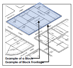
24. "Block frontage" means that section of a block fronting on the street right-of-way line between two intersecting streets or other block boundary.
25. "Board of Adjustment" means that board that has been created by the City and which has authority under the Code of Iowa to hear and determine appeals from and interpretations of variances, and to grant conditional use permits.
26. "Brownfield/brownfield site" means an abandoned, idled, or underutilized industrial or commercial facility where expansion or redevelopment is complicated by real or perceived environmental contamination.
27. "Buffer" means a strip of land established to protect one type of land use from another incompatible land use or between a land use and a private or public road. Also see "screening."
28. "Buffer area" means an open and unobstructed ground area of a plot in addition to any no building zones or street widening around the perimeter of any plot where required.
29. Buffer yard" means a landscaped area intended to separate and partially obstruct the view of two adjacent land uses or properties from one another.
30. "Buffer zone" means an area of land that separates two zoning districts and/or land uses and which acts to soften or mitigate the effects of one use on the other.
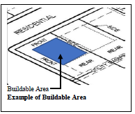
31. "Buildable area" means that part of a zoning lot not included within the required yards or subject to other restrictions herein required.
32. "Building" means any structure having a roof or partial roof supported by columns, posts, or walls for the enclosure of persons, animals, equipment, or chattels of any kind.
33. "Building, commercial or industrial" means a building or buildings where party walls or ownership lines exist in such a manner as to indicate the intent that they be separate buildings.
34. "Building, residential" means a building enclosed by a continuous wall regardless of the existence of platted lot lines through the area occupied by such building.
35. "Building area" means the sum in square feet of the ground areas occupied by all buildings and structures on a lot.
36. "Building code" means the various adopted codes of the City which regulate the construction of building, electrical, mechanical, plumbing, and other codes adopted by the City which pertain to building construction.
37. "Building coverage" means the area of a site covered by buildings or roofed areas, excluding allowed projecting eaves, balconies, and similar features.
38. "Building envelope" means the three-dimensional space within which a structure is permitted to be built on a lot after all zoning and other applicable municipal requirements have been met.
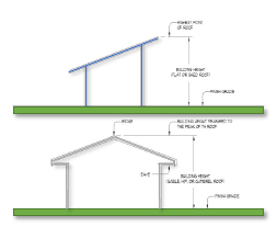
39. "Building height" means the distance measured from the mean elevation of the grade of the front face of the building to the highest point on the roof or parapet of the building.
40. "Building inspector" means the official appointed by the administration or the City Council, and charged with the responsibility of enforcing this Zoning Code.
41. "Building line" means the outer boundary of a building established by the location of its exterior walls.
42. “"Building permit" means a document issued under the authority of the Building Inspections and Code Enforcement Department, which permit authorizes the construction or modification of a structure on a property.
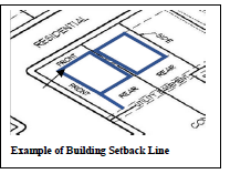
43. "Building setback line" means the required zoning distance between a building and the lot line.
44. "Bulk regulations" means an indication of size and setback of buildings and their location with respect to one another, including lot area, lot frontage, lot coverage, required front yard, required side yard, required rear yard, and building height.
45. "Certificate of occupancy" means a permit issued by the building inspector indicating the use of the building or land in question is in conformity with this Zoning Code or that there has been a legal variance therefrom as provided by this Zoning Code.
46. "City Administrator" means the City Administrator of the City of Sergeant Bluff, as appointed by the administration and City Council, or an authorized deputy, agent or representative.
47. "City Attorney" means the City Attorney of the City of Sergeant Bluff or an authorized deputy, agent or representative.
48. "City Engineer" means the City Engineer as hired or appointed by the Mayor and City Council or an authorized deputy, agent or representative.
49. "City limits" means the established corporate boundary of the City of Sergeant Bluff.
50. "Clear view zone" - see "sight triangle."
51. "Commission" means the Sergeant Bluff Planning and Zoning Commission.
52. "Common area or property" means a parcel or parcels of land, together with the improvements thereon, the use and enjoyment of which are shared by the owners of the individual building sites in a planned development or condominium development.
53. "Common development" means a development proposed and planned as one unified project not separated by a public street or alley.
54. "Common open space" means land within or related to a development that is not individually owned or dedicated for public use, designed and generally intended for the common use of the residents of the development.
55. "Compatibility" means harmony in the appearance of two or more external design features in the same vicinity.
56. "Compatible use" means the degree to which two or more different land use types are able to exist together in close proximity, with no one use having significant negative effects on any other use.
57. "Comprehensive Plan" shall mean the Comprehensive Development Plan of Sergeant Bluff, Iowa, as adopted by the City Council, setting forth policies for the present and foreseeable future community welfare.
58. "Conditional use" means a use where allowed by the district regulations, that would not be appropriate generally throughout the zoning district without restrictions, but which, if controlled as to number, size, area, location, relationship to the neighborhood or other minimal protective characteristics would not be detrimental to the public health, safety, and general welfare and which is permitted upon findings of the Board.
59. "Conditional use permit" means a permit issued by the Board of Adjustment that authorizes the recipient to make conditional use of property in accordance with the provisions of Sections 165C.01 and any additional conditions placed upon, or required by said permit.
60. "Conflicting land use" means the use of property which transfers over neighboring property lines negative economic or environmental effects, including, but not limited to, noise, vibration, odor, dust, glare, smoke, pollution, and water vapor, or consists of mismatched land uses, density, height, mass, or layout of adjacent uses, or results in a loss of privacy.
61. "Conservation" means the protection and care that prevent destruction or deterioration of historical or otherwise significant structures, buildings, or natural resources.
62. "Conservation area" means environmentally sensitive and valuable lands protected from any activity that would significantly alter their ecological integrity, balance or character, except in the case of an overriding public interest, including (but not limited to) wetlands, floodways, flood plains, drainage ways, river or stream banks, and areas of significant biological productivity or uniqueness.
63. "Conservation easement" means an easement granting a right or interest in real property that is appropriate to retaining land or water areas predominantly in their natural, scenic, open, or wooded condition and retaining such areas as suitable habitat for fish, plants, or wildlife, or maintaining existing land uses.
64. "Conservation subdivision" means, wholly or in majority, a residential subdivision that permits a reduction in lot area, setback, or other site development regulations, provided: (i) there is no increase in the overall density permitted for a conventional subdivision in a given zoning district; and (ii) the remaining land area is used for common space.
65. "Construction yards" means establishments housing facilities of businesses primarily engaged in construction activities, including incidental storage of materials and equipment on lots other than construction sites. Typical uses are building contractors' yards.
66. "Contiguous" - see "Abut or Abutting."
67. "Convent" means a place of residence for bona fide members of a religious order who carry on religious, medical, educational or charitable work.
68. "Corporate limits" means all land, structures, and open space that has been annexed into the City's jurisdiction. This does not include the extraterritorial jurisdiction of the City.
69. "Date of substantial completion" means the date certified by the local building inspector or Zoning Administrator when the work, or a designated portion thereof, is sufficiently complete, so the owner may occupy the work or designated portion thereof for the use for which it is intended.
70. "Density" means the number of dwelling units per gross acre of land.
71. "Developer" means any person, corporation, partnership, or entity that is responsible for any undertaking that requires a building or zoning permit, conditional use permit or sign permit.
72. "Development" means any man-made change to improved or unimproved real estate, including (but not limited to) buildings or other structures, mining, dredging, filling, grading, paving, excavation, or drilling operations for which necessary permits may be required.
73. "Development concept plan" - see "site plan."
74. "Development review" means the review, by the City, of subdivision plats, site plans, rezoning requests, or permit review.
75. "Development review committee" means a committee as defined in Section 165E.08 established to review site plans, planned developments and development proposals prior to any other required action.
76. "Disability" means physical or mental impairment that substantially limits one or more of major life activities so that such person is incapable of living independently, a record of having such an impairment, or being regarded as having such impairment.
77. "District or zone" means any zoning district created for the purpose of regulating specific uses within a defined area.
78. "Downzoning" means a change in zoning classification of land to a less intensive or more restrictive district, such as from commercial district to residential district or from a multiple-family residential district to single-family residential district.
79. "Drainage way" - see definition in Section 157.02 of this Code of Ordinances.
80. "Dwelling" means a building, containing living, sleeping, housekeeping accommodations, and sanitary facilities for occupancy by one or more families. In no case shall a motor home, trailer coach, automobile chassis, tent, or portable building be considered a dwelling.
81. "Dwelling, Apartment" means a room or a group of rooms, among similar sets in one building, designed for use as a dwelling usually rented and not owned by the occupant.
82. "Dwelling, Condominium/Condo" means an apartment house, office building, or other multiple-unit complex, the units of which are individually owned, each owner receiving a recordable deed to the individual unit purchased, including the right to sell.
83. "Dwelling, Duplex" means a multi-family home that has one legal description and one owner and is made up of two individual homes on one shared lot. Duplex buildings also have two separate entrances for each unit.
84. "Dwelling, Manufactured" (formerly known as mobile home) means a factory-built, single-family structure, which is built to the Manufactured Home Construction and Safety Standards (HUD Code) and is to be used as a place for human habitation, but which is not constructed with a permanent hitch or other device allowing it to be moved other that for the purpose of moving to a permanent site and which does not have permanently attached to its body or frame any wheels or axels. For the purpose of this title, a manufactured home shall be considered the same as any site-built, single-family detached dwelling.
85. "Dwelling, Mobile Home" (see also factory-built housing; manufactured housing) means any manufactured home built prior to June 15, 1976; they are now obsolete due to HUD policy changes in 1976; a transportable structure suitable for year-round single-family occupancy and having water, electrical, sewage connections similar to those of conventional dwellings.
86. "Dwelling, Modular" means a home constructed to the same state, local or regional building codes as site-built homes on a permanent chassis or on a e housing units for residential inhabitants are contained within one building or several buildings within one complex. Units can be next to each other (side-by-side) or stacked on top of each other (top and bottom units). A common form is an apartment building.
87. "Dwelling, Multi-Family" means a classification of housing where multiple separate housing units for residential inhabitants are contained within one building or several buildings within one complex. Units can be next to each other (side-by-side) or stacked on top of each other (top and bottom units). A common form is an apartment building.
88. "Dwelling, Seasonal or Cabins" means a dwelling which is designed or intended for seasonal or recreational use and is not intended for use as permanent living quarters.
89. "Dwelling, Single-family" means a structure that is usually occupied by just one household or family; open on all sides from any other structure.
90. "Dwelling, Single-family attached" means a housing unit connected to another housing unit, generally with a shared wall, that provides living space for one household or family. Townhouses, rowhouses, and duplexes are considered single-family attached housing units, as long as there is no household living above another one within the walls extending from the basement to the roof to separate the units. This includes modular homes but does not include manufactured homes.
91. "Dwelling, Single-family detached" is generally defined as a single-family dwelling; it is a permanent dwelling, usually set up on a separate lot and includes ownership rights to the land on which it is situated. A detached home is almost always considered a single-family home, meaning all internal areas are shared and in common. Also called single detached dwelling.
92. "Dwelling, Tiny Home/House" means a dwelling no larger than 400 square feet and placed on a permanent foundation with standard utility connections as prescribed by local or Iowa Code.
93. "Dwelling, Townhouse/Townhome" means an attached, privately owned single-family dwelling unit which is a part of and adjacent to other similarly owned single-family dwelling units that are connected to but separated from one another by a common party wall having no doors, windows, or other provisions for human passage or visibility.
94. "Dwelling, Twin Homes" means a home with a shared wall, each having its own legal description, classified as a single-family home with two owners.
95. "Dwelling, Two-family" means a detached residential building containing two dwelling units, designed for occupancy by not more than two families, but not including a single-family dwelling with an approved accessory dwelling unit.
96. "Dwelling, Upper Story" means a single-family living space one or more stories above ground level of an unused space above a commercial business; the space remodeled for use as dwellings.
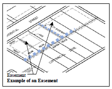
97. "Easement" means an authorization by a property owner for use by another, and for a specified purpose, of a designated part of the property.
98. "Emergency residential shelter" means a residential facility which provides room and board for a temporary (30 days or less) period, protection, counseling, and pre-placement screening for abused, displaced, or transient children or adults.
99. "Encroachment" means an advancement or intrusion beyond the lines or limits as designated and established by this Code of Ordinances.
100. "Enlargement" means the expansion of a building, structure, or use in volume, size, area, height, length, width, depth, capacity, ground coverage, or in number.
101. "Existing and lawful" means the use of a building, structure, or land was in actual existence, operation, and use, as compared to the use being proposed, contemplated, applied for, or in the process or being constructed or remodeled. In addition, the use must have been permitted, authorized, or allowed by law or any other applicable regulation prior to the enactment of a zoning regulation when first adopted or permitted, authorized, or allowed by the previous zoning regulation prior to the adoption of an amendment to that zoning regulation.
102. "Expansion" means the enlargement of a building, structure, or use in volume, size, area, height, length, width, depth, capacity, ground coverage, or in number.
103. "Exterior building component" means the general arrangement of any portion of a building, sign, landscaping, or structure and including the kind, color, and texture of the materials of such portion, and the types of roof, windows, doors, lights, attached or ground signs, or other fixtures appurtenant to such portions as will be open to public view from any street, place, or way.
104. "Extraterritorial jurisdiction" means the area beyond the corporate limits, in which the City has been granted the powers by the State to exercise subdivision review and is exercising such powers.
105. "Exurban" means the area that lies beyond the corporate limits and its suburbs.
106. "Federal" means the federal government of the United States of America.
107. "Findings of fact" means those factual items determined and recorded for either approving or denying any type of application as it pertains to the Planning and Zoning Commission, Board of Adjustment, Development Review Committee, and City Council.
108. "Flood" means a general and temporary condition of partial or complete inundation of normally dry land areas from: (i) the overflow of inland or tidal waters; or (ii) the unusual and rapid accumulation of runoff of surface waters from any source.
109. "Floodplain" means any land area susceptible to being inundated by water from any source as determined by the FIRM map.
110. "Flood proofing" means any combination of structural and non-structural additions, changes, or adjustments to structures, which reduce or eliminate flood damage to real estate or improved real property, water and sanitary facilities, structures and their contents.
111. "Floodway" means the channel of a watercourse and the adjacent land areas that must be reserved in order to discharge the base flood without cumulatively increasing the water surface elevation more than a designated height.
112. "Frontage" means that portion of a parcel of property or block that abuts a dedicated public street or highway.
113. "Frontage road" means a street adjacent to a freeway, expressway, or arterial street separated therefrom by a dividing strip and providing access to abutting properties.
114. "Grade" means the mean elevation of the ground measured along the wall of a building or a lot line, or the top of a street curb or official grade of a street curb not yet constructed, or an official grade of an alley surface, as appropriate to the context in which the term is used.
115. "Groundwater" means water naturally occurring beneath the surface of the ground that fills available openings in the rock or soil materials such that they may be considered saturated.
116. "Hard surfaced" means any surface used for movement of vehicular and/or pedestrian traffic that is designed and paved with either asphalt, concrete, permeable pavement, or pavers to City standards, but shall not include surfacing materials such as crushed rock, gravel, cinder, or surface sealants.
117. "Hazardous waste" means waste products of industrial or chemical process including finished surplus, used, contaminated or unwanted fertilizer, herbicide, petroleum products, or other such processed waste material.
118. "Hedge" mean a plant or series of plants, shrubs or other landscape material, so arranged as to form a physical barrier or enclosure.
119. "Height, maximum" means the total height of any structure including any signage or other attachments to a structure.
120. "Historic district" means an area designated as a historic district by ordinance and which contains within definable geographic boundaries, properties, or buildings, that may or may not be landmarks but which contribute to the overall historic character of the designated area.
121. "Home-based business/occupation, general" means a business, occupation, or profession carried on within a residential dwelling by the resident thereof.
122. "Impermeable surface" means a surface that has been compacted or covered with a layer of material making the surface highly resistant to infiltration by water, such as compacted sand, rock, gravel, or clay and conventionally surfaced streets, roofs, sidewalks, parking lots, and driveways.
123. "Improvement" means a any change to land necessary to prepare it for building sites, including (but not limited to) grading, filling, street paving, curb paving, sidewalks, walkways, water mains, sewers, drainageways, and other public works and appurtenances.
124. "Incidental use" means a use that is subordinate to the main use of a premises.
125. "Industrial, heavy" means enterprises involved in the basic processing and manufacturing of products, predominately from raw materials, with noticeable noise, odor, vibration, or air pollution effects across property lines; or a use or process engaged in the storage of or processes involving potentially or actually hazardous, explosive, flammable, radioactive, or other commonly recognized hazardous materials.
126. "Industrial, light" means establishments engaged in the manufacture or processing of finished products from previously prepared materials, including processing, fabrication, assembly, treatment, and packaging of such products, and incidental storage, sales, and distribution. These establishments are characterized by having no major external environmental effects across property lines and include no unscreened or unenclosed outdoor storage. Typical uses include commercial bakeries, dressed beef processing plants, soft drink bottling, apparel assembly from fabrics, electronics, manufacturing, print shops and publishing houses.
127. "Infill development" means the construction of a building or structure on a vacant parcel located in a predominantly built up area.
128. "Infill site" means any vacant lot, parcel or tract of land within developed areas of the City and where water, sewer, streets, schools, and fire protection have already been constructed or are provided a predominately built up area.
129. "Infrastructure" means facilities and services needed to sustain industry, residential, commercial, and all other land-use activities, including water lines, sewer lines, and other utilities, streets and roads, communications, and public facilities such as fire stations, parks, schools, etc.
130. "Intensification of use" means any change, alteration, extension, expansion or enlargement of a use or use of structure in combination where the off-street parking requirements of this Zoning Code would be calculated at a higher ratio and/ or would require that additional off-street parking spaces be provided.
131. "Intensity" means the degree to which land is used referring to the levels of concentration or activity in uses ranging from uses of low intensity being agricultural and residential to uses of highest intensity being heavy industrial uses. High intensity uses are normally uses that generate concentrations of vehicular traffic and daytime population and are less compatible with lower intensity uses.
132. "Irregular tract" means a parcel of land that has not been subdivided through adopted plat procedures, but nonetheless has been assigned a number for identification purposes.
133. "Lagoon" means a wastewater treatment facility that is a shallow, artificial pond where sunlight, bacterial action, and oxygen interact to restore wastewater to a reasonable state of purity. This includes both human and livestock wastes. All lagoons shall meet the minimum design criteria established by the IDNR.
134. "Landfill" means a disposal site employing a method of disposing solid wastes in a manner that minimizes environmental hazards in accordance with State and federal requirements.
135. "Lot" means a distinct parcel, tract or portion of a subdivision, the location, dimensions, and boundaries of which are determined by a plat.
136. "Lot, corner" (blue) means a lot located at the intersection of two or more streets at an angle of not more than 135 degrees. If the angle is greater than 135 degrees, the lot is considered an "interior lot."
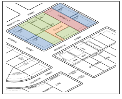
137. "Lot, double frontage, or through" (red) means a lot having a frontage on two non-intersecting streets as distinguished from a corner lot.
138. "Lot, flag" (orange) means an interior lot, the majority of which has frontage and access provided by means of a narrow corridor.
139. Lot, interior" (green) means a lot other than a corner lot.
140. "Lot area" means the total horizontal area included within the boundaries of the lot lines of a lot.
141. "Lot coverage" means that portion of a lot covered by principal and accessory uses and/or buildings expressed as a percentage of the lot area.
142. "Lot depth" means the horizontal distance between the front and rear lot lines measured in the mean direction of the side lot lines.
143. "Lot frontage" means the side of a lot abutting on a legally accessible street right-of-way other than an alley or an improved county road. For the purposes of this definition, on corner lots, all sides of a lot adjacent to streets or roads shall be considered frontage.
144. "Lot line" means the property line bounding a lot.
145. "Lot line, front" means the property line abutting a street.
146. "Lot line, rear" means a lot line not abutting a street which is opposite and most distant from the front lot line.
147. "Lot line, side" means any lot line not a front lot line or rear lot line.
148. "Lot of record" means a lot which is part of a subdivision recorded in the office of the County Recorder, or lot or parcel described by metes and bounds, the description to which has been so recorded.
149. "Lot width" means the average horizontal distance between the side lot line, measured at right angles to the lot depth at a point midway between the front and rear lot lines.
150. "Lot, zero lot line" means a common lot line on which a wall of a structure may be constructed.
151. "Lot, zoning" means a parcel of land of at least sufficient size to meet minimum zoning requirements for use, coverage, and area, and to provide such yards and other open spaces as are herein required. Such lot shall have frontage on an improved public street, or on the approved private street, and may consist of:
A. A single-lot of record;
B. A portion of a lot of record;
C. A combination of complete lots of record and portions of lots of record, or of portions of lots of record;
D. A parcel of land described by metes and bounds;
provided that in no case of division or combination shall any residual lot or parcel be created which does meet the requirements of this Zoning Code.
152. "Master fee schedule" means a fee schedule maintained by the City and passed, and amended periodically, which establishes the required fees to be collected for specific planning, zoning, and subdivision activities.
153. "Mini-storage or mini-warehouse" means a building or group of buildings containing individual, compartmentalized, and controlled access stalls or lockers for storage.
154. "Miscellaneous structures" means structures, other than buildings, visible from public ways. Examples are memorials, staging, antennas, water tanks and towers, sheds, shelters, fences, and walls, kennels, and transformers.
155. "Mixed use" means properties where various uses, such as office, commercial, institutional, and residential are combined in a single building or on a single site in an integrated development project with significant functional interrelationships and a coherent physical design.
156. "Mixed use building" means a building or structure that incorporates two or more use types within a single building or structure, provided that each use type is permitted within the individual base zoning district in which the building or structure is to be located.
157. "Mixed use development" means a single development that incorporates complementary land use types into a single development.
158. "Moratorium" means a temporary halting of specific development activities for a specific timeframe.
159. "Nonconforming building" means a building or portion thereof which was lawful when established but which does not conform to subsequently established zoning or zoning regulations.
160. "Nonconforming lot" means a lot having less area or dimension than that required in the district in which it is located and which was lawfully created prior to the zoning thereof whereby the larger area or dimension requirements were established, or any lot, other than one shown on a plat recorded in the office of the County Recorder, which does not abut a public road or public road right-of-way and which was lawfully created prior to the effective date of this Zoning Code.
161. "Nonconforming use" means a use lawful when established but which does not conform to subsequently established zoning regulations.
162. "Official zoning district map" means a map delineating the boundaries of zoning districts which, along with the zoning text, is officially adopted by the City Council.
163. "Old Town," for the purpose of this Zoning Code, refers to an area of the City that lies within the boundaries of First Street on the south, Interstate 29 on the west, Eighth Street on the north, and all properties addressed on G Street on the east.
164. "Open space" means that part of a lot or parcel not devoted to buildings, structures, parking or loading areas, driveways, or any principal or accessory use.
165. "Open space, common" means a separate and distinct area set aside as open space within or related to a development, and not on individually owned lots or dedicated for public use, but which is designed and intended for the common use or enjoyment of the residents of the development. Rights-of-way, private streets, driveways, parking lots, or other surfaces designed or intended for vehicular use or required yards shall not be included as common open space.
166. "Open space, usable" means an area of land or water or combination of land and water which may include complimentary structures and improvements within the site, excluding space devoted to parking, designed and intended for common use and enjoyment.
167. "Outdoor storage containers" means a fully enclosed, detached, and self-supporting structure, by itself incapable of motion or movement and not exceeding eight feet in width, 12 feet in height, and 40 feet in length or a total enclosed floor area of 320 square feet. The unit must be manufactured/assembled off-site and transportable, by means other than its own, to a location where it is set into place on a graded surface of concrete, asphalt, or gravel and not upon a foundation or wheels. It shall be made of metal or a similar stable, durable, and acceptable material and shall not include a foundation, electricity, plumbing, or other mechanical systems as part of its assembly or use.
168. "Overlay district" means a district in which additional requirements are imposed upon a use, in conjunction with the underlying zoning district. The original zoning district designation does not change.
169. "Parcel" means a lot or a contiguous group of lots in single ownership or under single control, which may be considered as a unit for purposes of development.
170. "Park" means any public or private land available for recreational, educational, cultural, or aesthetic use.
171. "Paved" means permanently surfaced with poured concrete or asphalt.
172. "Permanent foundation" means a base constructed from either poured concrete or laid masonry block and placed on a footing located below ground level to a point below the frost line upon which a building or structure is permanently attached.
173. "Permeable pavement" means a hard surfaced pavement system with traditional strength characteristics, but which allows rainfall to percolate through it rather than running off. For purposes of this Zoning Code, this does not include gravel, cinders, crushed rock or seal coat.
174. "Permanent storage" means the long-term storage on-site within an accessory building or structure.
175. "Permitted use" means any land use allowed without condition within a zoning district.
176. "Permanently attached" means attached to real estate in such a way as to require dismantling, cutting away, unbolting from permanent foundation or structural change in such structure in order to relocate it to another site.
177. "Planned unit development" (PUD) means a planning process and district for the purpose of providing for a unique and flexible arrangement of residential, business, or industrial uses in accordance with an approved conceptual plan.
178. "Planning and Zoning Commission" means the Planning and Zoning Commission of Sergeant Bluff, Iowa.
179. "Plat" means a map showing the location, boundaries, and legal description of individual properties.
180. "Pole building" means a structure built with no foundation or footings, using poles embedded directly in the ground as its primary support to hold metal, plastic, fiberglass or wood covering to form the building.
181. "Policy" means a statement or document of the City, such as the comprehensive plan, that forms the basis for enacting legislation or making decisions.
182. "Premises" means a tract of land, consisting of one lot or irregular tract, or more than one lot or irregular tract, provided such lots or tracts are under common ownership, contiguous, and used as a single tract, and includes a building or land within a prescribed area.
183. "Preservation" means the act of protecting an area, parcel of land, or structure from being changed or modified from the present character to another that is not representative of a specific period or condition.
184. "Principal structure" means the main building or structure on a lot, within which the main or primary use of the lot or premises is located. Within a residential district, the dwelling is the primary structure.
185. "Principal use" means the main use of land or structure, as distinguished from an accessory use.
186. "Prohibited use" means any use of land, other than nonconforming, which is not listed as a permitted use, conditional use, or accessory use within a zoning district.
187. "Property line" means the legal, platted boundary of a lot or parcel of land.
188. "Public utility" means all or part of a waterworks, gasworks, sanitary sewage system, storm water drainage system, electric light and power plant and system, heating plant, cable communication or television system, telephone or telecommunications systems or services offered separately or combined with any system or service specified herein or authorized by other state law, any of which may be owned by a City, including all land, easements, rights of way, fixtures, equipment, accessories, improvements, appurtenances, and other property necessary or useful for the operation of the utility.
189. "Public utility easement" means a portion of a lot or block in which the City and all public utilities enfranchised by the City have a rite of passage and/or a right to install and maintain pipes, wires, poles, conduits, and other equipment necessary to carry out public or quasi-public services.
190. "Public way" means any sidewalk, street, alley, highway, easement, or other public thoroughfare.
191. "Quasi-public use" means a use conducted by, or a facility or structure owned or operated by, a nonprofit, religious, or eleemosynary institution that provides educational, cultural, recreational, religious, or other similar types of public services.
192. "Queue space" means a temporary waiting area for motor vehicles obtaining a service or other activity.
193. "Railroad" means the land use including the right-of-way abutting railroad properties occupied by uses pertinent to the railroad operation and maintenance, but not including properties owned by the railroad and leased for use by others.
194. "Recreational vehicle" (RV) means a vehicular unit designed for recreational camping or travel use under its own power or designed to be mounted on or drawn by a motor vehicle. Recreational vehicle includes motor home, truck camper, travel trailer, camping trailer, and fifth wheel.
195. "Recreational vehicle park" means a tract of land upon which two or more recreational vehicle sites are located, established, or maintained for occupancy by recreational vehicles of the general public as temporary living quarters for recreation or vacation purposes by campers, vacationers, or travelers.
196. "Redevelopment" means the act of rehabilitation or demolition of existing buildings and/or land area irrespective of whether a change occurs in land use.
197. "Resource extraction" means a use involving on-site extraction of surface or subsurface mineral products or natural resources, excluding the grading and removal of dirt. Typical uses are quarries, borrow pits, sand and gravel operations, mining.
198. "Retention basin" means a facility for the temporary storage of storm water with a permanent water surface.
199. "Rezoning" means an amendment to or change in the Zoning Code, either to the text or map or both.
200. "Right-of-way" means an area or strip of land, either public or private, on which an irrevocable rite of passage has been dedicated, recorded, or otherwise legally established for the use of vehicles, utilities and/or pedestrians.
201. "Screening" means a structure or planting that conceals from public view the area behind such structure or planting.
202. "Semi-hard surfaced" means any surface which is four inches thick poured concrete, asphalt, crushed concrete (with minimum one and one-half inch aggregate) or crushed asphalt.
203. "Setback" means the minimum distance, as prescribed by this Zoning Code, measured from the edge of the eve or other similar building component located closest to the lot line.
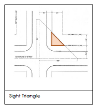
204. "Sight triangle" is an area at a street intersection in which nothing shall be erected, placed, planted, or allowed to grow in such a manner as to materially impede vision between a height of two and one-half feet and five feet above the grades of the bottom of the curb of the intersecting streets, measured from the point of intersection of the centerline of the streets along the centerline of the streets.
205. "Simple division" means any division of land in which no new streets, public or private, are proposed, which does not require the construction of any public improvements, and which creates fewer than three lots.
206. "Site" means the parcel of land to be developed or built upon. A site may encompass a single lot; a portion of a lot; or a group of lots developed as a common development under the special and overlay districts provisions of this Zoning Code.
207. "Site plan" means a plan, prepared to scale, showing accurately and with complete dimensioning, the boundaries of a site and the location of all buildings, structures, uses, drives, parking, drainage, landscape features, and other principal site development improvements for a specific parcel of land.
208. "Spot zoning" means the zoning of a small land area for a use which differs measurably from the zoned land use surrounding this area. Land may not merely be so zoned in the interest of an individual or small group, but must be in the general public interest.
209. "Street" means a public thoroughfare or right-of-way dedicated, deeded, or condemned for use as such, other than an alley, which affords the principal means of access to abutting property including avenue, place, way, drive, lane, boulevard, highway, road and any other thoroughfare except as excluded in this Zoning Code.
210. "Structure, temporary" means a building or structure erected for a one-time temporary use, lacking a permanent foundation, connections to water and sewer, and generally having open walls, distinct from a permanent structure which must meet adopted building codes.
211. "Subdivision" means a tract of land divided into three or more lots.
212. "Subdivision plat" means a graphical representation of the subdivision of land, prepared by a licensed land surveyor, having a number or letter designation for each lot within the plat and a succinct name or title that is unique.
213. "Surface waters" means all waters within the jurisdiction of the State, including all streams, lakes, ponds, impounding reservoirs, marshes, wetlands, watercourses, waterways, springs, canal systems, drainage systems, and all other bodies or accumulations of water, natural or artificial, public or private, situated wholly or partly within or bordering upon the State.
214. "Temporary use" means impermanent uses of an occasional nature. Temporary uses involve the use of permanent structures and portable signs. Uses of a seasonal nature that recur periodically on a regular basis on the same site and reoccupy the same permanent structure shall not be considered temporary uses.
215. "Tower" means a structure situated on a site that is intended for transmitting or receiving television, radio, or telephone communications. Also see "antenna."
216. "Tract" means a lot or contiguous group of lots in single ownership or under single control, usually considered a unit for purposes of development.
217. "Upper story housing" means one or more dwelling units located above the first floor where allowed within a commercial district.
218. "Up-zoning" means a change in zoning classification of land to a more intensive or less restrictive district such as from residential district to commercial district or from a single-family residential district to a multiple-family residential district.
219. "Utility service" means any device, including wire, pipe, and conduit, which carries gas, water, electricity, oil, wastewater and communications into a building or development.
220. "Variance" means a relief from or variation from the strict application of the bulk regulations, as applied to a specific piece of property, which may be granted by the ZBA according to the provisions of this Zoning Code.
221. "Vehicle," for the purposes of this Zoning Code only, shall be broadly interpreted to mean any implement of conveyance designed or used for the transportation of people or materials on land or water, including (but not limited to) automobiles, trucks, bicycles, motorcycles, snowmobiles, ATVs, boats (on a trailer), trailers of all kinds, campers, wagons, and farm implements.
222. "Visual obstruction" means any fence, hedge, tree, shrub, wall or structure exceeding two feet in height, measured from the crown of intersecting or intercepting streets, alleys or driveways, which limits the visibility of persons in motor vehicles on said streets, alleys, or driveways. This does not include trees kept trimmed of branches below a minimum height of five feet.
223. "Wireless communication tower" means a structure for the transmission or broadcast of cellular, radio, television, radar, or microwaves which exceed the maximum height permitted in the district in which it is located; provided, however, noncommercial radio towers not exceeding 50 feet in height shall not be considered wireless communication towers.
224. "Xeriscaping" means landscaping characterized by the use of vegetation that is drought-tolerant or a low water use in character.
225. "Yard" means any open space on the same lot with a building or a dwelling group, which open space is unoccupied and unobstructed from the ground upward to the sky, except for building projections or for accessory buildings or structures permitted by this Zoning Code.
226 "Yard, required front" (red) means an open space between the front yard setback line and the front lot line or highway setback line, and extending the full width of the lot.
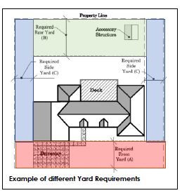
227. "Yard, required rear" (green) means an open space between the rear yard setback line and the rear lot line, extending the full width of the lot.
228. "Yard, required side" (blue) means an open space extending from the front yard, or from the front lot line where no front yard is required by this Zoning Code, to the rear yard, or rear lot line, between a side lot line and the side yard setback line.
229. "Zoning Administrator" means the person or persons authorized and empowered by the City to administer and enforce the requirements of this Zoning Code.
230. "Zoning district, change of" means the legislative act of removing one or more parcels of land from one zoning district and placing them in another zoning district on the zoning map of the City.
(Ord. 709 - Jul-21 Supp.)