ORDINANCE # 2024-03
AN ORDINANCE OF PLAIN CITY, UTAH AMENDING THE CITY’S SUBDIVISON ORDINANCE; AND ESTABLISHINGAN EFFECTIVE DATE
Section 1. Recitals
WHEREAS, The City Council finds, that the City of PLAIN CITY (herein “City”) is a municipal corporation duly organized and existing under the laws of the State of Utah; and
WHEREAS, the City Council finds that in conformance with the provisions of UCA § 10-3-717, the governing body of the city may exercise all administrative powers; and
WHEREAS, the City Council finds that in conformance with the provisions of UCA § 10-3-702, the governing body of the City may pass any ordinance to regulate, require, prohibit, govern, control, or supervise any activity, business, conduct or condition authorized by State law or any other provision of law; and
WHEREAS, the City Council finds that this issue has been reviewed by the Planning Commission and certain recommendations made by them; and
WHEREAS, the City Council finds that the public health, welfare and safety are at issue in this matter; now,
NOW THEREFORE, BE IT ORDAINED by the City of PLAIN CITY as follows:
Section 2. City’s Subdivision Ordinance Amended.
The following amendments are made to Title 11 Subdivision Regulations:
See attached Title 11 Subdivision Regulation amendments
Section 3. Prior Ordinances And Resolutions The body and substance of any and all prior Ordinances and Resolutions, together with their specific provisions, where not otherwise in conflict with this Ordinance, are hereby reaffirmed and readopted.
Section 4. Repealer Of Conflicting Enactments All orders, ordinances and resolutions with respect to the changes herein enacted and adopted which have heretofore been adopted by the City, or parts thereof, which are in conflict with any of the provisions of this Ordinance Amendment, are, to the extent of such conflict, hereby repealed, except that this repeal shall not be construed to revive any act, order or resolution, or part thereof, heretofore repealed.
Section 5. Savings Clause If any provision of this Ordinance shall be held or deemed to be or shall, in fact, be invalid, inoperative or unenforceable for any reason, such reason shall not have the effect of rendering any other provision or provisions hereof invalid, inoperative or unenforceable to any extent whatever, this Ordinance and the provisions of this Ordinance being deemed to be the separate independent and severable act of the City Council of Plain City.
Section 6. Date Of Effect This Ordinance shall be effective on the 7th day of March 2024, and after publication or posting as required by law.
DATED this 7th day of March, 2024
PLAIN CITY, a municipal corporation
____________________________________
MAYOR – Jon Beesley
ATTESTED AND RECORDED:
____________________________________
Diane Hirschi, CMC
CITY RECORDER
Ordinance #2024-03
TITLE 11
SUBDIVISION REGULATIONS
11-1 : Definitions
11-2 : General Provisions And Administration
11-3 : Development Procedure And Approval Process
11-4 : Assurance For Completion And Maintenance Of Improvements 11-5: Requirements For Improvements, Reservations And Design
11-6: Planned Residential Unit Development 11-7: Cluster Subdivisions
11-8: Subdivision Applications For 1–2 Family Residential
CHAPTER 1 DEFINITIONS
SECTION:
11-1-1 : Usage
11-1-2 : Definitions
11-1-1 : USAGE:
A. ? A.
For the purpose of these regulations, certain numbers, abbreviations, terms, and words used herein shall be used, interpreted, and defined as set forth in this section or chapter.
B. ? B.
Unless the context clearly indicates to the contrary words used in the present tense include the future tense; words used in the plural number include the singular; the word "herein" means "in these regulations"; the word "regulations" means these regulations.
C. ? C.
A "person" includes a corporation, partnership, and an unincorporated association of persons such as a club; "shall" is always mandatory; a "building" includes a "structure"; a "building" or "structure" includes any part "used" or "occupied" as applied to any land or building shall be construed to include the words "intended, arranged, or designed to be occupied". (Ord. 2001-02, 3-1-2001, eff. 3-1-2001)
11-1-2 : DEFINITIONS:
ADJACENT LANDOWNERS: Any property owner of record, according to the records of the county recorder, whose property adjoins or abuts property proposed for subdivision or any portion thereof.
ALLEY: A public or private right of way which is less than twenty six feet (26') wide primarily designed to serve as secondary access to the side or rear of those properties whose principal frontage is on some other street.
APPLICANT: The owner of land proposed to be laid out and platted or his agent. An agent shall be required to provide legal documentation to prove he has consent from the legal owner of the property.
BLOCK: A tract of land bounded by streets, or by a combination of streets and public parks, cemeteries, or boundary lines of municipalities.
BOND: A form of security, including a cash deposit, surety bond, collateral, property or instrument of credit in an amount and form satisfactory to the city council. All bonds shall be approved by the city council wherever a bond is required by these regulations.
BUILDING: Any structure built for the support, shelter or enclosure of persons, animals, chattels or movable property of any kind, and includes any structure.
BUILDING AREA: A portion of a lot, parcel or tract of land which is to be utilized as the building site having an area of at least two thousand five hundred (2,500) square feet with an average slope of less than twenty percent (20%). Such building area is to be designated as the only area in which building may take place and outlined on the subdivision plat in which the lot is located.
CAPITAL IMPROVEMENTS PROGRAM: A proposed schedule of
all
future city projects listed in order of
anticipated
construction priority, together with cost estimates and the anticipated means of financing each project. All major projects requiring the expenditure of public funds, over and above the annual city's operating expenses, for the purchase, construction or replacement of the physical assets for the community are included.
CITY: Plain City, Utah.
CITY COUNCIL: The city council of Plain City, Utah.
CITY ENGINEER: A professional, registered engineer retained by the city. CONSOLIDATION OF PARCELS: Combining of two (2) or more parcels of property.
COUNTY HEALTH OFFICER: The administrative and executive officer of the Weber County health department and local registrar of vital statistics or his duly authorized representatives.
DEVELOPER: The owner, or his agent, of land proposed to be laid out and platted in accordance with this subdivision title. An agent of the owner shall be required to provide legal documentation, to be approved by the city attorney, which establishes his authority to act as agent for the owner.
STREET, PRIVATE: A thoroughfare within a subdivision which has been reserved by dedication unto the developer or lot owners to be used as private access to serve the lots platted within the subdivision. Private streets shall comply with the adopted street cross section standards of the City and shall be maintained by the developer or other private agency.
A. ?
SUBDIVISION: Any land that is divided, resubdivided or proposed to be divided into two (2) or more lots, parcels, sites, units, plots, or other division of land for the purpose, whether immediate or future, for offer, sale, lease or development either on the installment plan or upon any and all other plans, terms, and conditions.
Subdivision includes: a) the division or development of land whether by deed, metes and bounds description, devise and testacy, lease, map, plat, or other recorded instrument; and b) divisions of land for all residential and nonresidential uses, including land used or to be used for commercial, agricultural and industrial purposes.
1. ?Subdivision includes:
i) The division or development of land, whether by deed, metes and bounds description, devise and testacy, map, plat, or other recorded instrument, regardless of whether the division includes all or a portion of a parcel or lot; and
ii) Except as provided below, divisions of land for residential and nonresidential uses, including land used or to be used for commercial, agricultural, and industrial purposes.
2. ?Subdivision does not include:
i) A bona fide division or partition of agricultural land for the purpose of joining one of the resulting separate parcels to a contiguous parcel of unsubdivided agricultural land, if neither the resulting combined parcel nor the parcel remaining from the division or partition violates an applicable land use ordinance;
ii) A boundary line agreement recorded with the Office of the County Recorder between owners of adjoining parcels adjusting the mutual boundary in accordance with §10-9a-524 of Utah State Code (as amended) if no new parcel is created;
iii) A recorded document, executed by the owner of record revising the legal descriptions of multiple parcels into one legal description encompassing all such parcels or joining a lot to parcel;
iv) A boundary line agreement between owners of adjoining subdivided properties adjusting the mutual lot line boundary in accordance with §10- 9a-524 and §10-9a-608 of Utah State Code (as amended) if no new dwelling lot or housing unit will result from the adjustment and the adjustment will not violate any applicable land use ordinance;
v) A bona fide division of land by deed or other instrument if the deed or other instrument states in writing that the division is in anticipation of future land use approvals on the parcel or parcels does not confer any land use approvals, and has not been approved by the land use authority;
vi) A parcel boundary adjustment;
vii) A lot line adjustment;
viii) A joining of one or more lots to a parcel;
ix) A road, street, or highway dedication plat;
x) A deed or easement for a road, street, or highway purpose; or
xi) Any other division of land authorized by law.
SUBDIVISION, MINOR: Any subdivision with two (2) lots existing on a dedicated street sewer that has culinary water, and secondary water accessible.
UTILITIES: Gas lines, culinary water lines, storm drainage systems, irrigation systems, sewer lines, electric power transmission lines, telephone transmission lines, cable television systems with all poles, wires, pipes, guywires and bracing pertaining thereto.
WETLANDS: Generally, those areas that are inundated or saturated by surface or ground water at a frequency and duration sufficient to support, and that under normal circumstances do support, a prevalence of vegetation typically adapted for life in saturated soil conditions. When in conflict, Federal definitions and standards shall prevail.
ZONING ORDINANCE: The zoning ordinance of Plain City as adopted by the City Council and as amended from time to time. (Ord. 2001-02, 3-1-2001, eff. 3-1-2001; amd. Ord. 2003-13, 12-4-
2003, eff. 12-4-2003; Ord. 2008-13, 9-19-2008, eff. 9-19-2008; Ord. 2014-03, 5-15-2014, eff. 5-
15-2014; Ord. 2017-07, 5-18-2017, eff. 5-19-2017; Ord. 2022-04, 3-17-2022, eff. 3-17-2022;
Ord. 2022-08, 5-19-2022, eff. 5-19-2022)
CHAPTER 2
GENERAL PROVISIONS AND ADMINISTRATION
SECTION:
11-2-1 : Title
11-2-2 : Policy
11-2-3 : Purposes
11-2-4 : Jurisdiction
11-2-5 : Interpretation, Conflict And Separability 11-2-6: Saving Provision
11-2-7: Reservations And Appeals
inconsistent with these regulations or determinations thereunder, then such private provisions shall be operative and supplemental to these regulations and determinations made thereunder. Nothing contained therein shall empower or require the City to enforce such private agreements or restrictions.
C. C.
Separability: If any part or provision of these regulations or application thereof to any person or circumstances is adjudged invalid by any court of competent jurisdiction, such judgment shall be confined in its operation to the part, provision or application directly involved in the controversy in which such judgment shall have been rendered and shall not affect or impair the validity of the remainder of these regulations or the application thereof to other persons or circumstances. The City Council hereby declares that it would have enacted the remainder or these regulations even without any such part, provision or application. (Ord. 2001-02, 3-1-2001, eff. 3-1-2001)
11-2-6 : SAVING PROVISION:
These regulations shall not be construed as abating any action now pending under, or by virtue of, prior existing subdivision regulations, or as discontinuing, abating, modifying or altering any penalty accruing or about to accrue, or as affecting the liability of any person, firm or corporation, or as waiving any right of the City under any section or provision existing at the time of adoption of these regulations, or as vacating or annulling any rights obtained by any person, firm or corporation, by lawful action of the City except as shall be expressly provided for in these regulations. (Ord. 2001-02, 3-1-2001, eff. 3-1-2001)
11-2-7 : RESERVATIONS AND APPEALS:
A. ?
Upon the adoption of this title according to law, the subdivision ordinance of the City adopted January 27, 1976, as amended, is hereby repealed, except as to such sections expressly retained herein. (Ord. 2001-02, 3-1-2001, eff. 3-1-2001)
B. ? Appeals of land use decisions under this Title shall be conducted as described in section
11-8-6.
11-2-8 : AMENDMENTS:
This title may be amended from time to time by the City Council after holding a public hearing upon proper notice. All proposed changes and amendments shall be proposed by or submitted to the Planning Commission for its recommendation, which, within thirty (30) days, shall be forwarded to the City Council for its consideration. Failure of the Planning Commission to submit a recommendation within the prescribed time shall be deemed approval by such commission of the proposed change or amendment. The City Council shall uphold or overrule the recommendation of the Planning Commission by a majority vote of its members within thirty
(30) days following the final vote of the Planning Commission. (Ord. 2001-02, 3-1-2001, eff. 3- 1-2001)
b. ? (ii)
Explanation of irrigation easements, if any.
c. ? (iii)
Explanation of site easements, if any.
d. ? (iv)
Explanation of reservations, if any.
6. 6.
Review: Plats must be presented to the City Recorder at least thirty (30) days prior to a regular meeting of the commission. This thirty (30) day period is necessary to allow the Planning Commission and designated consultants time to review the plat and prepare for its consideration at a regular meeting held for such purpose. (Ord. 2009-05, 5-7-2009, eff. 5-7-2009)
1.7. Technical Review Engineering, Legal,
And Inspection Fees: The applicant shall pay for all engineering,
planninglegal
, and
legal inspection
fees associated with the proposed lot line adjustment. (Ord. 2009-05, 5-7-2009, eff. 5-7-2009; amd. Ord. 2017-14, 12-7-2017, eff. 12-8-2017)
B. ? B.
Consolidation Of Parcels:
1. ? 1.
Upon approval of the Planning Commission, contiguous lots may be combined to form one development site unless a subdivision amendment is required. Such lots will be considered consolidated, and shall meet all requirements concerning parcel consolidation. Once two (2) or more contiguous parcels have been consolidated, they may not be divided without meeting all applicable zoning requirements.
C. Parcel Consolidation:
2. ? 1.
Conditions: A building permit or other approvals from the City shall not be issued to any new or modified development that is contained within more than one contiguous legal parcel or subdivision lot unless the parcels are consolidated into one lot with one tax identification number.
3. ? 2.
Application: Application materials for the lot line adjustment shall include the following:
i) a.
Completed application signed by all affected property owners.
ii) ? b.
Legal description of the whole piece of property to be consolidated.
iii) c.
Copies of deeds reflecting the new property boundaries.
iv) ? d.
One (1) eleven by seventeen (11 x 17) drawing to scale of the existing plat and one (1) eleven by seventeen (11 x 17) drawing to scale of the proposed plat. All plats shall show all structures on the property, fence lines, easements, driveways, and streets, and include a measurement scale.
4. ? 3.
Recordation: Parcel consolidation shall be accomplished by recording an appropriate deed with the County Recorder's Office. The new legal description shall not create a remnant parcel or violate existing zoning ordinances.
5. ? 4.
Exempt: Agricultural operations are exempt from this requirement.
6. ? 5.
General: If necessary, the Planning Commission may require the following additional information:
i) a.
A plat (drawn to scale) prepared in ink by a licensed land surveyor or engineer of a convenient scale not more than one hundred feet to an inch (1" = 100'), and the sheets shall be numbered in sequence if more than one sheet is used and shall be of such size as is acceptable for filing in the Office of the County Recorder. The plat shall:
(a) ? (1)
Be accompanied by one reduced eleven inch by seventeen inch (11" x 17") copy of the full size drawings.
(b) (2)
Be accompanied by an electronic copy in required format.
(c) ? (3)
Be presented to the City Recorder at least thirty (30) days prior to a regular meeting of the commission. This thirty (30) day period is necessary to allow the Planning Commission and designated consultants time to review the plat and prepare for its consideration at a regular meeting held for such purpose. (Ord. 2009-05, 5-7-2009, eff. 5-7-2009)
7. ? 6. Engineering, Legal, And Inspection Fees: The submitterapplicant
shall pay for all engineering
fees, planner, legal
, and
legal inspection
fees associated with the proposed consolidation of parcels. (Ord. 2009-05, 5-7-2009, eff. 5-7-2009; amd. Ord. 2017-14, 12-7-2017, eff. 12-8-2017)
11-2-13 : RESERVED:
(Ord. 2008-13, 9-19-2008, eff. 9-19-2008)
11-2-14 : PUBLIC WORKS STANDARDS:
The public works standards are hereby adopted by reference as if fully set out herein. (Ord. 2002-11, 6-20-2002, eff. 6-20-2002; amd. 2003 Code; Ord. 2008-13, 9-19-2008, eff. 9-19-2008)
11-2-15 : VALIDITY:
A. ? A.
Any plat of a subdivision filed or recorded without the approvals as required by this title is void.
B. ? B.
Any sale or transfer of any land in a subdivision not platted in accordance with the provisions of this title is null and void. (Ord. 2001-02, 3-1-2001, eff. 3-1-2001; amd. Ord. 2008-13, 9-19-2008, eff. 9-19-2008)
11-2-16 : ENFORCEMENT AND INSPECTIONS:
11-3-1 : GENERAL PROCEDURE:
Whenever any subdivision is proposed or created, the owner, or the owner's authorized agent, shall prepare a plat which shall comply with the rules, regulations and requirements of this title before:
A. ? A.
It may be filed or recorded in the County Recorder's Office;
B. ? B.
Lots may be sold or offered for sale; and
C. ? C.
Any building permit for the erection of a nonagricultural structure shall be granted. (Ord. 2001-02, 3-1-2001, eff. 3-1-2001)
11-3-2 : ADMINISTRATION AND ENFORCEMENT:
A. ? A.
Purpose And Intent: The purpose of this title is to establish regulations and procedures for the processing and consideration of subdivision applications.
B. ? B.
Land Use Authority: The Planning Commission is designated as the Land Use Authority for the approval of lot line adjustments and minor subdivisions.
C. ? C.
Interpretation: In their interpretation and application, the provisions of these regulations shall be held to be the minimum requirements for the promotion of the public health, safety and general welfare. The Planning Commission is designated as the Land Use Authority to interpret this title.
D. ? D.
Fees For Processing Applications:
1. ? 1.
Fees for processing applications shall be established by the Plain City consolidated fee schedule.
2. ? 2. The City may impose additional fees on an applicant equal to the actual costs of engineering, planning, legal, inspection, or other review of a subdivision application.
3. ?Neither a preliminary nor final subdivision application shall be approved or considered complete until the applicant has paid all required fees to the City.
4. ?
Applications that have been deemed complete and have not been pursued with reasonable diligence before the appropriate board shall expire after six (6) months. The applicant will have to submit a new application and fees to restart the process.
E. ? E.
Notice Of Decision: After hearing the evidence and considering the application, the approving authority (Planning Commission), shall make its findings and have them entered in the minutes. Upon a decision by the approving authority, a notice of decision shall be mailed to the applicant at the address or e-mail address given in the application. A notice of decision can be a written notice or a copy of the approved minutes. A decision by the approving authority is final at the time the notice of decision is issued. If a notice of decision is not sent, the decision shall be final on the date the minutes from the meeting are approved by the approving authority. The City Recorder shall also mail notice of any
decisions to any person or agency who, in writing, requested such notification before the decision was rendered. Decisions are subject to requirements and conditions stated in the staff report and listed in the meeting minutes.
F. ? F.
Hearing And Publication Notice For The Planning Commission And City Council: At least ten (10) days' notice of the time and place of which shall be given of any public hearing before the Planning Commission as per State Code. (Ord. 2017-14, 12-7-2017, eff. 12-8-2017)
11-3-3 : TECHNICAL REVIEW:
A. ? A.
Process: The City periodically hosts a Technical Review Committee (TRC) meeting. In order for a preliminary plat to be scheduled for a TRC meeting, a complete preliminary plat application must be received and accepted by the City prior to a date approximately one month prior to the TRC meeting at which the applicant desires the project to be discussed. The City Recorder's Office maintains this schedule.
B. ? B.
Meeting With Representatives: The applicant is provided an opportunity to meet with representatives from all applicable utilities and other interested governmental agencies to receive comments regarding the preliminary plat application. At this meeting, the applicant will also receive written comments from the City, detailing the extent to which the plans are required to be revised in order for the City to schedule Land Use Authority consideration of their application. Extensive revisions caused by the TRC comments or by voluntary action of the applicant, may require additional TRC meetings.
C. ? C.
Timetables: Critical path preliminary plat processing project timetables, including monthly preliminary plat application deadlines, TRC meeting dates, required resubmittal dates and Land Use Authority meeting dates are established and maintained by the City Recorder's Office. (Ord. 2017-14, 12-7-2017, eff. 12-8-2017)
11-3-4 : PRELIMINARY PLAT:
A. ? A.
General: The preliminary plat shall be prepared in ink by a licensed land surveyor or engineer of a convenient scale not more than one hundred feet to an inch (1" = 100'), and the sheets shall be numbered in sequence if more than one sheet is used and shall be of such size as is acceptable for filing in the Office of the County Recorder. The preliminary plat shall: (Ord. 2001-02, 3-1-2001, eff. 3-1-2001; amd. Ord. 2017-14, 12-7-2017, eff. 12-
8-2017)
1. ? 1.
Be accompanied by a minimum of
nineteen (19) twenty four seven (7) eleven- inch by
thirty six seventeen-
inch (
2411
" x
3617
") copies of the preliminary plat as described in these regulations and
one reducedseven (7) eleven -inch by seventeen
inch (11" x 17") copy of the full size drawings. Also required are: one (1) eleven by seventeen (11-inch (11” x 17
) and nine (9) twenty four by thirty six (24 x 36)”)
sets of aerial maps,
awith each set
to includeincluding two (2) maps
,: one map showing
a close up of the subdivision (with legend included) and the second map
showing approximately one thousand feet (1,000') around the boundaries of the subdivision in all directions. Need to includeThe applicant must also provide
a digital file
alsoof these documents
.
2. ? 2. Plats must beBe
presented to the City Recorder at least thirty (30) days prior to a regular meeting of the commission. This thirty (30) day period is necessary to allow the Planning Commission and designated consultants time to review the plat and prepare for its consideration at a regular meeting held for such purpose. (Ord. 2006-12, 6-15-2006, eff. 6-15-2006; amd. Ord. 2017-14, 12-7-2017, eff. 12-8-2017)
B. ? B.
Features: The preliminary plat shall contain the following:
1. ? 1.
The location of property with respect to surrounding property and streets, the names of all adjoining property owners of record, or the names of adjoining developments and the names of adjoining streets.
2. ? 2.
The location and dimensions of all boundary lines of the property to be expressed in feet and decimals of a foot.
3. ? 3.
The location of existing streets, easements, water bodies, streams and other pertinent features such as wetlands, buildings, parks, cemeteries, drainage ditches, irrigation ditches, fences, bridges, etc., as determined by the Planning Commission.
4. ? 4.
The location, width and details of all existing and proposed streets, curbs, gutters, sidewalks, easements, alleys, other public ways and easements and proposed street rights-of-way and building setback lines.
5. ? 5.
The locations, dimensions and areas of all proposed or existing lots, illustrating their relationship to surrounding properties.
6. ? 6.
The location and dimensions of all property proposed to be set aside for park or playground use, or other public or private reservation, with designation of the purpose thereof and conditions, if any, of the dedication or reservation.
7. ? 7.
The name and address of the owner or owners of land to be laid out and platted, the name, address and phone number of the developer if other than the owner, and the name, address and phone number of the land surveyor or engineer.
8. ? 8.
The date of the plat, approximate true north direction, scale and title of the subdivision.
9. ? 9.
Sufficient data acceptable to the City Engineer to readily determine the location, bearing and length of all lines, and to reproduce such lines upon the ground, and the location of all proposed monuments, including contours at intervals of two feet (2'), five feet (5') or ten feet (10'), as determined by the City Engineer.
10. ? 10.
Name of the subdivision and name and number of all new streets.
The subdivision name must be distinct from any subdivision name on a plat recorded in the County Recorder's office.
11. ? 11.
Indication of the use of any lot (single-family, two-family, multi-family, townhouse) and all uses other than residential as proposed by the developer.
12. ? 12.
All lots consecutively numbered.
13. ? 13.
Existing water supply and sanitary sewage systems.
14. ? 14.
Detailed provisions for collecting and discharging surface water drainage.
15. ? 15.
Location and size of all proposed water, secondary water, sanitary sewer, storm sewer, irrigation or drainage ditch piping or other subsurface improvements as deemed necessary by the City Engineer.
16. ? 16.
Preliminary plats shall contain the following notations:
i) a.
Explanation of drainage easements, if any.
ii) ? b.
Explanation of irrigation easements, if any.
iii) c.
Explanation of site easements, if any.
iv) ? d.
Explanation of reservations, if any. (Ord. 2001-02, 3-1-2001, eff. 3-1- 2001; amd. Ord. 2017-14, 12-7-2017, eff. 12-8-2017)
C. ? C. Notice to Affected Entities: Within 15 days after receiving a complete subdivision application under this Chapter, the Land Use Authority shall provide written notice of the proposed subdivision to the facility owner of any water conveyance facility located, entirely or partially, within 100 feet of the subdivision plat. To determine whether any water conveyance facility is located within 100 feet of a proposed subdivision, the Land Use Authority shall review information:
1. ?From the facility owner under Utah Code §10-9a-211, using mapping-grade global positioning satellite units or digitized data from the most recent aerial photo available to the facility owner;
2. ?From the state engineer's inventory of canals; or
3. ?From a licensed surveyor who has consulted with a representative of an existing water conveyance facility that services an area near the land the application concerns.
D. ?
Preliminary Approval: After the Planning Commission has reviewed the preliminary plat, the report from the City staff and any Municipal recommendations, the applicant shall be advised of any required changes and/or additions. The commission shall then approve, table, conditionally approve or disapprove the preliminary plat. A notice of decision will be sent to the developer outlining the decision of the Planning Commission. Before the commission approves a preliminary plat showing park reservation or land for other City use proposed to be dedicated to the City, the developer shall obtain approval of the park or land reservation from the City Council. (Ord. 2017-14, 12-7-2017, eff. 12-8-2017)
E. ? D.
Effective Periods Of Preliminary Approval: The approval of a preliminary plat shall be effective for a period of twelve (12) months only from the date of approval. Any plat
C. ? C.
Location, size, elevation and other appropriate description of any existing facilities or utilities, including, but not limited to, existing streets, sewers, drains, water mains, easements, fences, street lights, water bodies, streams, wetlands, irrigation and drain ditches and any other pertinent features at the point of connection to proposed facilities and utilities within the subdivision.
D. ? D.
All specifications and references required by the City's public works standards, including a site grading plan for the entire subdivision when required by the City Engineer.
E. ? Improvement plans must include the following documents:
1. ?A geotechnical soils report prepared within the last six months from the date of application in accordance with the City’s Public Works Standards.
2. ?A traffic study when required by the Public Works Director or designee or the City Engineer or designee.
3. ?Any necessary agreements with adjacent property owners regarding storm drainage, utility provisions, access, or other matters pertinent to subdivision approval.
F. ? E.
All improvement plans shall be prepared and stamped by a civil engineer, registered in the State. (Ord. 2001-02, 3-1-2001, eff. 3-1-2001; amd. Ord. 2017-14, 12-7-2017, eff.
12-8-2017)
11-3-6: FINAL PLAT:
A. ? A.
General: The final plat shall consist of a sheet of approved Mylar. Size of drawings shall be twenty four inches by thirty six inches (24" x 36") with a one-half inch (1/2") border on top, bottom and right side. The left side shall have a border of one and one-half inches (11/2"). The plat shall be so drawn that the top of the drawing faces either north or west, whichever best accommodates the drawing. All lines, dimensions and markings shall be made on the Mylar with approved waterproof black India drawing ink. The plat shall be made to a scale large enough to clearly show all details, in any case not smaller than one hundred feet to the inch (1" = 100'), and workmanship on the finished drawing shall be neat, clean cut and readable. The plat shall contain the following information:
1. ? 1.
The subdivision name approved by the Planning Commission, and the general location of the subdivision, in bold letters at the top of the sheet.
2. ? 2.
A north point and scale of the drawing, and the date.
3. ? 3.
Accurately drawn boundaries, showing the property bearings and dimensions of all boundary lines of the subdivision; properly tied to public survey monuments. These lines should be slightly heavier than street and lot lines.
4. ? 4.
The address or name, width, lengths, bearings and curve data on centerlines of proposed streets, alleys and easements; also the boundaries, bearings and dimensions of all portions within the subdivision, as intended to be dedicated to the use of the public;
and the lines, dimensions, bearings and numbers of all lots. All proposed streets shall be numbered or named in accordance with the adopted addressing system of the City.
5. ? 5.
The standard forms approved by the Planning Commission lettered for the following:
i) a.
Description of land to be included in a subdivision.
b.
Registered land surveyor's "certificate of survey".
ii) ? " as described in Utah Code §10-9a-603(6)(
c
. )).
iii)
Owner's dedication and acknowledgment.
iv) ? d. If the plat is to be part of a community association, an instrument conveying to the association all common areas.
v) ?
Notary public's acknowledgment.
vi) ? e.
Certificate of approval by the Planning Commission.
vii) f.
Certificate of approval by the City Engineer.
viii) ? g.
Certificate of approval by the City Attorney.
ix) ? h.
Certificate of acceptance by the City Council, attested by the City Recorder.
6. ? 6.
A three inch by three inch (3" x 3") space in the lower right hand corner of the drawing for County recording information.
B. ? B.
Preparation: The final plat shall be prepared by a registered land surveyor licensed by the State. (Ord. 2001-02, 3-1-2001, eff. 3-1-2001; amd. Ord. 2017-14, 12-7-2017, eff. 12-
8-2017)
C. ? C.
City Recorder: Plats must be presented to the City Recorder at least thirty (30) days prior to the meeting at which final approval is sought or contemplated. (Ord. 2006-12, 6- 15-2006, eff. 6-15-2006; amd. Ord. 2017-14, 12-7-2017, eff. 12-8-2017)
D. ? D.
Requirements For Final Approval:
1. ? 1.
Materials Needed For Approval: Final approval of the final plat may not be granted until the following materials are submitted to the Planning Commission: (Ord. 2001-02, 3-1-2001, eff. 3-1-2001; amd. Ord. 2006-12, 6-15-2006, eff. 6-15-2006; Ord.
2017-14, 12-7-2017, eff. 12-8-2017)
i) a.
A minimum of
nine (9) twenty four seven (7) eleven-
inch by
thirty six seventeen-
inch (
2411
" x
3617
") copies of the final plat and three (3) copies of the improvement plans
and one reduced eleven inch by seventeen inch (11" x 17") copy of the full size final drawings
, as described in these regulations, which comply in all respects with the preliminary plan, as approved, and which have been reviewed and approved by the City Engineer; (Ord. 2004-05, 6-3-2004, eff. 6-3-
2004; amd. Ord. 2006-12, 6-15-2006, eff. 6-15-2006; Ord. 2017-14, 12-7-2017, eff.
12-8-2017
)).
ii) ? b.
All formal irrevocable offers of dedication to the public of all streets, City uses, utilities, parks and easements in a form approved by the City Attorney;
iii) c.
Written assurance from the public utility companies and improvement districts that necessary utilities will be installed and proof that the applicant has submitted petitions in writing for the creation or extension of any improvement districts as required by the Planning Commission upon preliminary plan approval;
d. All required processing and checking fees have been paid to the City. (Ord. 2001- 02, 3-1-2001, eff. 3-1-2001; amd. Ord. 2006-12, 6-15-2006, eff. 6-15-2006; Ord. 2017-14,
12-7-2017, eff. 12-8-2017)
2. ? 2.
Final Approval By Planning Commission: The Planning Commission shall take action on the final plat after the applicant has satisfied the preliminary plat approval conditions. The City Engineer will provide a recommendation prior to being placed on the Planning Commission agenda. The Planning Commission shall recommend to the City Council the approval, conditional approval or disapproval of the final plat within thirty (30) days after the date the plat is submitted to the Planning Commission. The commission shall set forth in detail any conditions to which the recommendation is made or reason for its recommendation. The subdivision plat shall then be forwarded to the City Council for their approval. Requests to extend final approvals shall be conducted at six (6) month intervals for a total of eighteen (18) months.
E. ?
The developer shall have a period of six (6) months to conduct a pre-construction meeting with City staff and start construction of the infrastructure within the development. If such work has not been completed the developer must file a request to extend the time for installation of improvements.
1. ? 3.
Completion Of Improvements Determination By City Council: Upon receiving the recommendation of the Planning Commission, the City Council shall consider the recommendation at a regularly scheduled City Council meeting and shall approve, modify and approve, or disapprove the final plat by resolution which shall set forth in detail any conditions to which the approval is subject or reasons for disapproval. In no event shall the period of time stipulated by the City Council for completion of required improvements exceed two (2) years from the date the final plat is recorded as identified in chapter 4 of this title. A notice of decision will be sent as identified in subsection 11- 3-2E of this chapter. (Ord. 2017-14, 12-7-2017, eff. 12-8-2017)
2. ? 4.
Materials Testing: The developer shall be responsible for payment of materials testing required by the City Engineer during construction of subdivision improvements.
3. ? 5.
Plat Approval Required: No street improvements or utilities shall be installed until after approval of the final plat by the City Council and recordation thereof. No lots included in such plat shall be purchased, sold, exchanged, nor offered for sale or exchange; and no construction of buildings upon such lots shall begin until the final
1. ? 1.
The subdivision name approved by the Planning Commission and the general location of the subdivision, in bold letters at the top of the sheet.
2. ? 2.
A north point and scale of the drawing, and the date.
3. ? 3.
Accurately drawn boundaries, showing the property bearings and dimensions of all boundary lines of the subdivision; properly tied to public survey monuments. These lines should be slightly heavier than street and lot lines.
4. ? 4.
The address, width, lengths, bearings and curve data on centerlines of proposed streets, alleys and easements; also the boundaries, bearings and dimensions of all portions within the subdivision, as intended to be dedicated to the use of the public; and the lines, dimensions, bearings and numbers of all lots. All proposed streets shall be numbered in accordance with the adopted addressing system of the City.
5. ? 5.
The standard forms approved by the Planning Commission lettered for the following:
i) a.
Description of land to be included in a subdivision.
ii) ? b.
Registered land surveyor's "certificate of survey".
iii) c.
Owner's dedication and acknowledgment.
iv) ? d.
Notary public's acknowledgment.
v) ? e.
Certificate of approval by the Planning Commission.
vi) ? f.
Certificate of approval by the City Engineer.
vii) g.
Certificate of approval by the City Attorney.
6. ? 6.
A three inch by three inch (3" x 3") space in the lower right hand corner of the drawing for County recording information.
B. ? B.
Preparation: The preliminary/final plat shall be prepared by a registered land surveyor licensed by the State.
C. ? C.
City Recorder: Plats must be presented to the City Recorder at least thirty (30) days prior to the meeting at which preliminary/final approval is sought or contemplated. Note: This will result in the applicant being added to the Planning Commission's list of unscheduled items. This is done on a first come, first served basis. The Planning Commission may limit the number of items on an upcoming agenda.
D. ? D.
Requirements For Final Approval:
1. ? 1.
Materials Needed For Approval: Final approval of the final plat may not be granted until the following materials are submitted to the Planning Commission:
i) a.
A minimum of
nineteen (19) twenty four inch by thirty six inch (24" x 36") copies of the preliminary/final plat and one reducedseven (7)
eleven -inch by seventeen -inch (11" x 17")
copycopies of the
full size
preliminary/final
drawingsplat
, as described in these regulations,
which comply in all respects with the preliminary/final plat, as approved, and which have been reviewed and approved by the City Engineer;
ii) ? b.
An electronic copy of the plat in required format;
iii) c.
All formal irrevocable offers of dedication to the public of all streets, City uses, utilities, parks and easements in a form approved by the City Attorney;
iv) ? d.
Written assurance from the public utility companies and improvement districts that necessary utilities will be installed and proof that the applicant has submitted petitions in writing for the creation or extension of any improvement districts as required by the Planning Commission upon preliminary plan approval;
v) ? e.
A deferral agreement signed prior to receiving final approval from the Planning Commission;
vi) ? f.
All required
application
processing and
checkingreview fees have been paid to the City. (Ord. 2013-11, 10-3-2013, eff. 10-4-2013; amd. Ord. 2017-14, 12-
7-2017, eff. 12-8-2017)
E. ? E.
Preliminary/Final Approval By Planning Commission: In one meeting, the Planning Commission may grant preliminary/final approval. The City Engineer will provide a recommendation prior to being placed on the Planning Commission agenda. The commission shall set forth in detail any conditions to which the recommendation is made or reason for its decision.
F. ? F.
Materials Testing: The developer shall be responsible for payment of materials testing required by the City Engineer during construction of subdivision improvements.
G. ? G.
Plat Approval Required: No street improvements or utilities shall be installed until after approval of the final plat and recordation thereof. No lots included in such plat shall be purchased, sold, exchanged, nor offered for sale or exchange; and no construction of buildings upon such lots shall begin until the final plat is so approved and recorded. (Ord. 2017-14, 12-7-2017, eff. 12-8-2017)
H. ? H.
Mylar Copy: Mylar copy of the approved subdivision plat needs to be submitted for signatures. All lines, dimensions and markings shall be made on the mylar with approved waterproof black india drawing ink.
I. ? I.
Electronic Copy Of Signed Plat Required: An electronic copy of the signed plat shall be submitted to the City in the required format.
J. J.
Conditions Completed: All conditions associated with preliminary and final approval must be completed prior to the issuance of building permits. (Ord. 2013-11, 10-3-2013, eff. 10-4-2013; amd. Ord. 2017-14, 12-7-2017, eff. 12-8-2017)
11-3-9: AGRICULTURAL SUBDIVISION EXEMPTION
A. ? Applications to subdivide agricultural land are exempt from the plat requirements of this Chapter if the applications meet the relevant requirements in Utah Code §10-9a-605(2).
B. ? Notwithstanding clause A, the boundaries of each lot or parcel in the agricultural subdivision shall be graphically illustrated on a record of survey map that, after receiving both a preliminary and final approval in accordance with this Chapter, shall be recorded with the County Recorder.
C. ? If a lot or parcel exempted under this Section is used for a nonagricultural purpose, the Planning Commission may require the plat requirements of this Chapter.
CHAPTER 4
ASSURANCE FOR COMPLETION AND MAINTENANCE OF IMPROVEMENTS
SECTION:
11-4-1 : Improvements And Guarantee 11-4-2: Inspection Of Improvements
11-4-3: Acceptance Of Off Site Improvements 11-4-4: Special Exception For Sidewalk
11-4-5: Issuance Of Building Permits And Certificates Of Occupancy
11-4-1 : IMPROVEMENTS AND GUARANTEE:
A. ? A.
Methods For Installation: The owner of any land which has been laid out, platted and recorded pursuant to the provisions of this title shall at his own expense install the required improvements within a period of two (2) years from the date the final plat is recorded. Said owner shall guarantee the installation of such improvements by one of the following methods designated by the City:
1. ? 1.
Deposit In Escrow: The developer will deposit in escrow with an escrow holder approved by the City Council an amount of money equal to the cost of improvements required plus ten percent (10%) as estimated by the developer and approved by the City Engineer under an escrow agreement conditioned for the installation of said improvements within two (2) years from the date the final plat is recorded. The escrow agreement aforesaid shall be approved by the City Council and City Attorney and shall be filed with the City Recorder. The ten percent (10%) improvement guarantee amount will be held for one year beyond the date of conditional final acceptance of improvements.
2. ? 2.
Financial Institution Bond - An agreement with a financial institution federally or state insured to release certain construction funds upon approval by the City. The amount of the bond shall be equal to the cost of improvements required plus ten
iii) n.
Streets shall be numbered unless the Planning Commission determines, based upon topography and other like considerations, that streets should be named.
7. ? 4. Blocks:
i) a.
Blocks shall have sufficient width to provide for two (2) tiers of lots of appropriate depths. Exceptions to this prescribed block width may be permitted in blocks adjacent to major streets, waterways or topography concerns.
ii) ? b.
The lengths, widths and shapes of blocks shall be such as are appropriate for the locality and the type of development contemplated, but block lengths in residential areas shall not exceed one thousand three hundred twenty feet (1,320') or twelve (12) times the minimum lot width required in the zoning district, whichever is less, nor be less than four hundred feet (400') in length. Wherever practicable, blocks along major streets and collector streets shall be not less than six hundred sixty feet (660') in length.
iii) c.
In long blocks, the Planning Commission may require the reservation of an easement through the block to accommodate utilities, drainage facilities or pedestrian traffic.
iv) ? d. PedestrianwaysPedestrian ways
or crosswalks, not less than six feet (6') wide, may be required by the Planning Commission through the center of blocks more than eight hundred feet (800') long where deemed essential to provide circulation or access to schools, playgrounds, shopping centers, transportation or other community facilities.
v) ? e.
To prevent landlocked property, the City Council and/or Planning Commission may require additional access roads.
8. ? 5.
Access To Major Streets: Where a subdivision borders on or contains an existing or proposed major street, the Planning Commission may require that access to such streets be limited by one of the following means:
i) a.
The subdivision of lots so as to back onto the street and front onto a parallel local street; no access shall be provided from the street in the rear, and screening shall be provided in a strip of land no less than five feet (5') in width along the rear property line of such lots.
ii) ? b.
A marginal access or service road (separated from the street by a planting or grass strip and having access thereto at suitable points).
9. ? 6.
Street Regulatory Signs:
i) a.
The applicant shall deposit to the City, at the time of final subdivision approval, a sum determined by the Director of Public Works for each sign required by the City. The City shall install all street signs before issuance of certificates of occupancy for any residence on the streets approved.
11-7-3 : SITE DEVELOPMENT STANDARDS:
A. ? A.
Minimum Lot Area: The minimum lot area for dwellings may be reduced below the area normally required in the zone in which the cluster subdivision is located, but no lot shall have an area less than two-thirds (2/3) of the minimum lot area required for such dwelling in the respective zone.
B. ? B.
Minimum Lot Width And Yard Setbacks: The minimum lot width and side yard may be reduced below the side yard normally required in the zone in which the cluster subdivision is located, but no lot shall have a width or side yard of less than three-fourths (3/4) of the minimum lot width or side yard required in the respective zone.
C. ? C.
Number Of Lots Allowed: Total number of lots for the development shall be determined by the amount of buildable land rather than total acreage that may contain unbuildable land such as, but not limited to, wetlands. (Ord. 2002-13, 11-7-2002, eff. 11-7- 2002)
11-7-4 : OPEN SPACE PROVISION:
There shall be permanently reserved within the subdivision for recreation and/or open space, parcels of land whose total area is not less than the amount by which the areas of the residential lots are reduced below the minimum area normally required in the zone in which the cluster subdivision is located. (Ord. 2002-13, 11-7-2002, eff. 11-7-2002)
11-7-5 : OPEN SPACE PRESERVATION AND MAINTENANCE:
Recreation and/or open space areas to be permanently reserved shall be imposed, landscaped and maintained in accordance with a plan approved by the Planning Commission and the cluster subdivision provision of this title. (Ord. 2002-13, 11-7-2002, eff. 11-7-2002)
11-7-6 : PROCEDURE:
A preliminary plan of the cluster subdivision showing the areas within the subdivision to be permanently reserved for recreation and/or open space, and plans showing the proposed use, improvements and method of maintenance of such areas shall be approved by the Planning Commission before the cluster subdivision proposal becomes allowed. (Ord. 2002-13, 11-7- 2002, eff. 11-7-2002)
CHAPTER 8
SUBDIVISION APPLICATIONS FOR 1–2 FAMILY RESIDENTIAL
11-8-1 : PURPOSE:
The purpose of this Chapter is to comply with Utah Code §10-9a-604–604.9 and increase administrative efficiency in reviewing subdivision applications.
11-8-2 : SCOPE OF APPLICABILITY:
This Chapter applies to all subdivision-related applications or petitions where the intended use is one- or two-family residential dwellings, including townhomes and duplexes. This Chapter does not apply to applications or petitions for other uses.
11-8-3 : INTERPRETATION AND CONFLICT OF LAWS:
Where any provision in this Subdivision Chapter conflicts with state law, state law shall prevail. Where any provision in this Subdivision Chapter conflicts with other ordinances enacted by the City, the provisions in this Subdivision Chapter shall prevail unless the City intended such conflicting ordinances not in this Chapter to amend this Chapter.
11-8-4 : DEFINITIONS:
The following words and phrases, as used in this Chapter, shall have the following meanings. Words and phrases not defined here have the meaning expressed elsewhere in this Title or, if not defined in this Title, the meaning defined by state law:
B. LAND USE AUTHORITY: an individual, board, or commission appointed or employed by a municipality to make land use decisions.
C. PLAT: An instrument subdividing property into lots as depicted on a map or other graphic representation of land that a licensed professional land surveyor makes and prepares in accordance with §10-9a-603 or §57-8-13 of Utah State Code (as amended).
D. ? IMPROVEMENT PLAN: a plan to complete permanent infrastructure on the subdivision that is essential for the public health and safety or that is required for human occupation and that an applicant must install in accordance with public installation and inspection specifications for public improvements and as a condition of recording a subdivision plat.
E. ? LAND USE APPLICATION: an application required by the City and submitted by a land use applicant to obtain a land use approval; this does not mean an application to enact, amend, or repeal a land use regulation.
11-8-5 : SUBDIVISION LAND USE AUTHORITY:
A. ? The Land Use Authority under this Chapter, except where otherwise noted, is the Planning Commission.
B. The Land Use Authority is responsible for the following, but may delegate any task to the Technical Review Committee or other City staff:
1. ?Rendering a land use decision on all subdivision applications and petitions under this Chapter.
2. ?Reviewing all applications under this Chapter in an impartial manner and according to the standards and deadlines described in this Chapter.
3. ?Providing feedback to applicants in the manner required by this Chapter.
4. ?Scheduling and holding a pre-application meeting with potential applicants as
requested.
5. ?Keeping subdivision application forms and related informational material up to date and publicly accessible and distributing such forms and materials to potential
applicants.
6. ?Providing notice to entities and parties as required in this Chapter.
7. ?Signing application and petition approvals as required in this Chapter.
8. ?Ensuring that documents are properly recorded with the County as required in this
Chapter.
C. As Subdivision application decisions are administrative, not legislative, the Land Use Authority is authorized to make any land use decision described by this Chapter without City Council approval.
D. ? Except when operating as the Appeal Authority, the City Council shall not require the Land Use Authority to approve or deny an application under this Chapter.
11-8-6 : SUBDIVISION APPEAL AUTHORITY:
A. ? The Appeal Authority for City decisions relating to this Chapter, except where otherwise noted, is the City Council.
B. The Appeal Authority shall hear appeals on final decisions made by the Land Use Authority and shall hear complaints about the conduct of the Land Use Authority in administering the provisions of this Chapter.
C. A party appealing or complaining of a Land Use Authority decision under this Chapter must exhaust its remedies under this section (by appealing or complaining to the Appeal Authority) before bringing an action against the City in a court of law.
D. ? A party who has submitted a subdivision application or petition may appeal or complain to the Appeal Authority under this Chapter. In such an appeal or complaint, the party may appeal or complain only regarding the Land Use Authority’s treatment of that party’s own application; a third party may not appeal or complain of Land Use Authority decisions or conduct.
E. A party desiring to appeal or complain of a Land Use Authority decision shall submit to the Appeal Authority the following in writing:
1. ?A brief explanation of the relief the party is seeking, the reason the party submitted its application or petition, the Land Use Authority’s decision and treatment of the application or petition, and why the applicant believes the Land
Use Authority misapplied the provisions of this Chapter or abused the discretion given it by this Chapter.
2. ?The most recent version of the application or petition the party submitted.
3. ?Any supplemental documentation or information that the Appeal Authority
requests.
4. ?All appeals and complaints must be emailed or mailed to the City Recorder using the Recorder’s official City address and/or email account listed on the City
website.
F. After receiving a complete appeal or complaint in accordance with this Section, the Appeal Authority shall deliver a decision to the applicant, in writing, no later than 30 calendar days after the Appeal Authority receives the appeal or complaint.
11-8-7 : APPLICATION REQUIREMENTS:
A. ? To be considered complete, a subdivision application must include at least the following
elements:
1. ?An approved land use application that describes how the property will be used after it is subdivided.
i) If the intended use is permitted by right under City ordinances, the land use application must include citations to the specific ordinance(s) that the applicant believes authorizes the intended use.
ii) If the intended use requires a conditional use permit or is otherwise conditioned on City approval, the land use application must include an
approved, City-issued permit authorizing the intended use. Should an applicant seek a use permit concurrently with a related subdivision application, the subdivision application shall be considered incomplete until the use permit is issued.
iii) If the intended use is prohibited under City ordinances and requires a variance, the land use application must include an approved, City-issued variance authorizing the intended use. Should an applicant seek a variance concurrently with a related subdivision application, the subdivision application shall be considered incomplete until the variance is issued.
2. ?A plat. The plat must be drawn to scale, in detail, and in accordance with generally accepted surveying standards and the acceptable filing standards of the County Recorder’s office. The plat must include:
i) The proposed name and general location of the subdivision, in bold letters at the top of the plat. The proposed subdivision name must be distinct from any subdivision name on a plat recorded in the County Recorder's
office.
ii) The boundaries, course, numbering, and dimensions of all proposed parcels. All lots should be consecutively numbered.
iii) The lot or unit reference; block or building reference; street or site address; street name or coordinate address; acreage or square footage for all parcels, units, or lots; and length and width of the blocks and lots intended for sale.
iv) The names and addresses of all adjoining property owners of record, or the names of adjoining developments and the names of adjoining streets.
v) The address and phone number of the land surveyor and/or engineer who prepared the plat.
vi) Sufficient data acceptable to the City Engineer to readily determine the location, bearing and length of all lines on the plat, and to reproduce such lines upon the ground, and the location of all proposed monuments, including contours at appropriate intervals.
vii) Whether any parcel is intended to be used as a street or for any other public use.
viii) The names, numbers, widths, lengths, bearings, and curve data on centerlines for all proposed streets, alleys, and easements (if applicable). All proposed streets shall be numbered and named in accordance with the City’s adopted addressing system.
ix) ? The location of existing streets, easements, water bodies, streams, and other pertinent features such as wetlands, buildings, parks, cemeteries, drainage ditches, irrigation ditches, fences, and bridges.
x) The location and width of existing and proposed streets, curbs, gutters, sidewalks, easements, alleys, other public ways and easements and proposed street rights-of-way and building setback lines.
xi) Every existing right-of-way and recorded easement located within the plat for underground, water, and utility facilities.
xii) Any known and unrecorded water conveyance facility located, entirely or partially, within the plat.
xiii) Location and size of all proposed water, secondary water, sanitary sewer, storm sewer, irrigation or drainage ditch piping or other subsurface improvements, including detailed provisions for collecting and discharging surface water drainage.
xiv) Whether any parcel is reserved or proposed for dedication for a public
purpose.
xv) The location and dimensions of all property proposed to be set aside for park or playground use, or other public or private reservation, with designation of the purpose thereof and conditions, if any, of the dedication or reservation.
xvi) As applicable, formal, irrevocable offers for dedication to the public of streets, City uses, utilities, parks, easements, or other spaces.
xvii) One copy of the plat drawn on Mylar for signing and recording and seven 11” x 17” printed copies for the City’s use in the review process. The applicant must also provide a digital version of the plat.
xviii) Seven sets of two 11” x 17” aerial maps: one map showing a close up of the proposed subdivision (with legend included) and the second map showing the area approximately 1,000 feet around the boundaries of the subdivision in all directions. The applicant must also provide a digital version of the maps.
3. ?An improvement plan, created in accordance with applicable portions of §11-3-5 and chapters 11-5 and 11-4 of this Title, for all public improvements proposed by the applicant or required by City ordinances.
4. ?Certifications, including:
i) An affidavit from the applicant certifying that the submitted information is true and accurate.
ii) The signature of each owner of record of land described on the plat, signifying their dedication and approval of the plat.
iii) Certification that the surveyor who prepared the plat:
(a) ? Holds a license in accordance with Utah Code 58-22; and
(b) Either
1. ?Has completed a survey of the property described on the plat in accordance with state requirements and has verified all measurements; or
2. ?Has referenced a record of survey map of the existing property boundaries shown on the plat and verified the locations of the boundaries; and
(c) ? Has placed monuments as represented on the plat.
iv) Proof of approval by the culinary water authority, the sanitary sewer authority, the local health department, the local fire department, and the local public safety answering point.
v) If the plat is to be part of a community association, signed and binding documents conveying to the association all common areas.
5. ?An electronic copy of all plans in PDF format.
6. ?Payment of any application-processing fees required by the City.
B. The Land Use Authority shall produce, maintain, and make available to the public a list of the specific items that comprise a complete land use application, plat, and improvement plan and a breakdown of any fees due upon submission or approval of the
application.
C. The Land Use Authority may require, and the applicant shall provide, additional information beyond the requirements of this Section or those published by the Land Use Authority relating to an applicant’s plans to ensure compliance with municipal ordinances and approved standards and specifications for construction of public
improvements.
11-8-8 : PRE-APPLICATION MEETING:
A. ? A party intending to submit a subdivision application under this Chapter may request a pre-application meeting with the Land Use Authority for the purpose of reviewing any element of the party’s proposed subdivision application. The proposed application need not be complete for purposes of this meeting and may—if the party desires—be limited to a concept plan.
1. ?If a party requests a pre-application meeting, the Land Use Authority shall schedule the meeting within 15 business days after the request. The meeting shall be scheduled at the earliest convenient opportunity, and, at the option of the party requesting the meeting, shall occur within 45 business days after scheduling.
2. ?The Land Use Authority (or a member of the body that makes up the Land Use Authority) shall conduct the meeting, provide feedback on materials as requested by the party, and shall provide or have available on the municipal website the following at the time of the meeting:
i) Copies of applicable land use regulations,
ii) A complete list of standards required for the project, and
iii) Relevant application checklists.
11-8-9 : NOTICE TO AFFECTED ENTITIES:
A. ? Within 15 calendar days after receiving a complete subdivision application under this Chapter, the Land Use Authority shall provide written notice of the proposed subdivision to the facility owner of any water conveyance facility located, entirely or partially, within 100 feet of the subdivision plat.
1. ?To determine whether any water conveyance facility is located within 100 feet of a proposed subdivision, the Land Use Authority shall review information:
i) From the facility owner under Utah Code §10-9a-211, using mapping- grade global positioning satellite units or digitized data from the most recent aerial photo available to the facility owner;
ii) ? From the state engineer's inventory of canals; or
iii) ? From a licensed surveyor who has consulted with a representative of an existing water conveyance facility that services an area near the land the application concerns.
B. To give water conveyance facilities time to provide feedback on subdivision applications, the Land Use Authority shall not approve a subdivision application under this Chapter sooner than 20 calendar days after the applicant submits a complete application. This waiting period does not apply to revised applications the applicant may submit during the application review process.
1. ?A water conveyance facility owner's failure to provide comments to the Land Use Authority about a subdivision application does not affect or impair the Land Use Authority’s authority to approve the subdivision application.
11-8-10 : REVIEW:
A. ? The Land Use Authority shall review all subdivision applications under this Chapter in accordance with the requirements of this Section before approving or denying a subdivision application.
B.
The review process begins when an applicant submits a complete application.
1. ?The Land Use Authority shall not review an incomplete subdivision application, except to determine whether the application is complete.
2. ?If the Land Use Authority determines that an application is not complete, it shall notify the applicant of the incompleteness, highlighting any insufficiencies and explaining that the application will not be reviewed until completed.
C. After the applicant submits a complete application, the Land Use Authority shall review and provide feedback to the applicant in up to four “review cycles.”
1. ?A review cycle consists of the following phases:
i) Phase #1: The applicant submits a complete application (or, if after the first cycle, submits a revised version of the complete application).
ii) Phase #2: The Land Use Authority reviews the application in detail and assesses whether the application conforms to local ordinances.
iii) Phase #3: The Land Use Authority responds to the applicant, citing any missing requirements or areas of noncompliance and providing a detailed list of necessary revisions to the applicant, within 15 business days after the applicant submitted the complete application. For any required modification or addition to the application or request for more information, the Land Use Authority shall be specific and include citations to ordinances, standards, or specifications that require the modification and shall provide the applicant with an index of all requested modifications or additions.
iv) Phase #4: The applicant revises the application, addressing each comment or requirement the Land Use Authority made. The applicant must submit both revised plans and a written explanation in response to the municipality’s review comments, identifying and explaining the
applicant’s revisions and reasons for declining to make revisions, if any. This written explanation shall be comprehensive and specific, including citations to applicable standards and ordinances and an index of requested revisions or additions for each required correction. If the applicant fails to respond to a comment made by the Land Use Authority in its review, the review cycle is not complete and will remain open until the applicant addresses all comments.
D. ? The Land Use Authority shall not (nor shall any other representative of the municipality) require more than four review cycles for a subdivision application under this Chapter. If no further revisions are needed, the Land Use Authority may end the review period early and approve or deny the application.
1. ?This provision notwithstanding, for any subdivision application that affects property within an identified geological hazard area, the City is exempt from limits on the number of permitted review cycles and the City’s deadlines for reviewing and responding (Phases #2 and #3).
2. ?If the applicant makes a material change to the application not requested by the municipality at any point in the review process, the review process may, at the option of the Land Use Authority, restart from the beginning of the first review cycle but only with respect to the portion of the application that the material change substantively effects.
3. ?If an applicant takes longer than 20 business days to submit a revised application and respond to the City’s requests for modifications and additions (Phases #1 and #4), the City shall have an additional 20 business days to review and respond to the revised application (Phases #2 and #3 of the next review cycle or issuing an approval decision).
4. ?If an applicant takes longer than 180 calendar days to submit a revised application and respond to the City’s requests for modifications and additions (Phases #1 and #4), the application shall, at the option of the Land Use Authority, expire. If an application expires, the applicant must restart the subdivision application process.
E. After the fourth or final review cycle is complete, the Land Use Authority shall approve or deny the application within 20 business days.
1. ?If the Land Use Authority has not approved or denied the application within 20 business days after the fourth or final review, the applicant may request a final decision. After such a request, the municipality shall, within 10 business days:
i) For a dispute arising from the subdivision improvement plans, assemble an appeal panel in accordance with Utah Code §10-9a-508(5)(d) to review and approve or deny the final revised set of plans; or
ii) For a dispute arising from the subdivision ordinance review, advise the applicant, in writing, of the deficiency in the application and of the right to appeal the determination to the designated Appeal Authority.
F. After the Land Use Authority provides comments in the fourth or final review cycle, the municipality shall not require further modifications or corrections unless those modifications or corrections are needed to protect public health and safety or to enforce state or federal law or unless the review cycle reset due to the applicant making a material change that the Land Use Authority did not request.
1. ?With the exception of modifications or corrections that are needed to protect public health and safety, that are needed to enforce state or federal law, or that arise from the review cycle bring reset, the municipality waives noncompliant subdivision-related requirements that the Land Use Authority does not identify during the review process.
2. ?The applicant shall make reasonable changes, unless prohibited otherwise by a contract or deed, to the subdivision application to accommodate the water conveyance facility to the extent required by Utah Code §73-1-15.5.
G. ? The municipality may conduct one (but no more than one) public hearing for the purpose of asking questions of the applicant and receiving commentary on the technical aspects of the application from affected entities, interested parties, and the public. If the municipality elects to hold this public hearing, the hearing must occur before the end of the Land Use Authority’s review period in the fourth or final review cycle. Scheduling issues shall not extend the review and approval deadlines in this Chapter.
H. ? Other chapters of this Title notwithstanding, the Land Use Authority shall approve or deny a subdivision application under this Chapter after reviewing a complete subdivision application as described in this Section. This singular application and review process includes the combined elements of traditional “preliminary” and “final” applications, as those terms are used in Utah Code §10-9a-604.2.
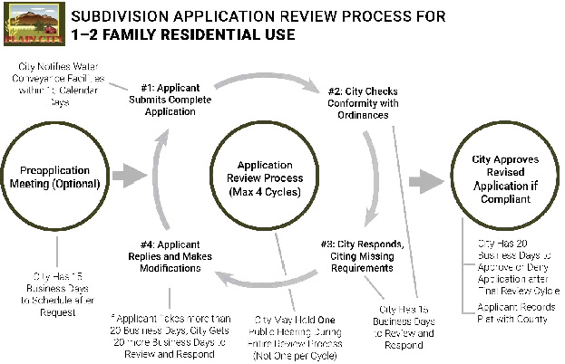
11-8-11 : APPROVAL:
A. ? The Land Use Authority shall approve any complete subdivision application made under this Chapter that complies with applicable municipal ordinances.
B. ? A subdivision application is approved when:
a. ? The Land Use Authority sends to the applicant a Notice of Decision, signed by the Land Use Authority; and
b. ?The Land Use Authority certifies the approved plat, either by signing the plat directly or by attaching a signed certification to the plat.
11-8-12 : POST-APPROVAL ACTIONS:
A. ? The applicant shall record the approved subdivision plat with the County Recorder’s Office within 365 calendar days after the municipality approves the subdivision application, provided that the applicant has completed any improvements or posted any completion assurance required by City ordinances (notably by chapters 11-4 and 11-5) or described in the approved improvement plan. The applicant shall not record the approved final plat until such improvements are completed or assured in compliance with City ordinances and the approved improvement plan.
B. ? An approved plat not properly recorded within the timeline specified in 11-8-12(A) is void, unless the Land Use Authority approves an extension.