Each land use is either permitted by right or by special exception. For the purposes of administering and enforcing this chapter, the location of a given land use shall be as prescribed by the Official Schedule of Uses. Any use not designated by a "P" or "S" in the subject district shall be considered to be a prohibited use in the subject district. The Administrative Officer may determine into which category a use is placed if it is not specifically listed but is similar to another use that is listed in the Official Schedule of Uses. This determination may be appealed to the Board of Zoning Appeals pursuant to §§ 154.200 through 154.210, Procedures and Permits, of this chapter.
(A) Compatibility with surrounding land uses. All proposed developments within the town will be reviewed for their compatibility with the surrounding neighborhoods, the natural environment, and their ability to create pleasing transitions between land uses. To decrease the level of incompatibility between residential and non-residential uses, landscape buffers may be required. Refer to § 165.120, Buffering and Screening Standards, of this chapter.
(B) Residential uses.
(1) Determining density and open space.
(a) To allow greater flexibility and variety in the creation of residential subdivisions while preserving significant community and natural resources, residential subdivisions are required to arrange the residential units on areas of the project site best suited for development and protect at least 25% of the land for open space uses. A minimum of 6% of the land shall be for active or passive recreation purposes. Open spaces must be accessible to residents of the subdivision without crossing a private lot.
(b) Residential development within a project may not exceed the gross density of the identified on Chapter 154, Appendix B, Bulk Use Standards Matrix, of this chapter. No minimum lot size is required, but the applicant must meet all of the other development standards of the residential zoning classification and the requirements of this chapter.
(c) The development potential of the property is determined by multiplying the area of the tract times the density permitted by the zoning district.
(d) The minimum open space requirement is calculated by multiplying the area of the tract by 0.25. The recreation open space requirement is calculated by multiplying the area of the tract by 0.06.
(e) Land designated for open space uses shall be restricted from further subdivision through the use of conservation easements in a form acceptable to the County Recorder and duly recorded in the County Recorder's Office.
(f) Storm water management ponds or basins, land within the rights-of-way of underground pipelines, and floodplain areas may be included as part of the minimum required open space. Road rights-of-way may not be included as a part of the minimum required open space.
(2) Evaluation criteria. In evaluating the layout of lots and open space, the following criteria will be considered by the Plan Commission as indicating design appropriate to the site's natural, historic, and cultural features and meeting the purposes of this chapter. Diversity and originality in lot layout shall be encouraged to achieve the best possible relationship between development and conservation areas. The Plan Commission shall evaluate proposals to determine whether the proposed subdivision:
(a) Protects and preserves all floodplains, wetlands, and slopes greater than 20% from clearing, grading, filling, or construction to the greatest extent possible.
(b) Preserves and maintains mature woodlands and existing agricultural fields and creates sufficient buffer areas to minimize conflicts between residential and agricultural areas.
(c) Maintains and creates a buffer of natural species vegetation at least 100 feet wide adjacent to wetlands and surface waters, including creeks, streams, springs, lakes, and ponds.
(d) Designs around existing hedgerows and tree lines between fields and minimizes impacts on woodlands greater than five acres in size. Woodlands on highly erodible slopes should also be avoided.
(e) Protects wildlife habitat areas of species listed as endangered, threatened, or of special concern by the US Environmental Protection Agency and/or the Indiana Department of Natural Resources.
(f) Improves public safety and vehicular carrying capacity by avoiding development fronting directly onto existing public roads.
(g) Organizes the subdivision where the largest practicable number of lots abuts open space areas in order to provide direct views and access to open space.
(h) Provides recreational areas in suitable locations that offer convenient access by residents and adequate screening from nearby lots.
(i) Includes a pedestrian circulation system designed to ensure that pedestrians can walk safely and easily on the site, between properties and activities or special features within the neighborhood open space system.
(j) Provides open space that is reasonably contiguous. Fragmentation of open space should be minimized so that resource areas are not divided into numerous small parcels located in various parts of the development. To the greatest extent practicable, this land shall be designated as a single
block with logical, straightforward boundaries with a length-to-width ratio not to exceed 4:1. Long, thin open space areas shall be avoided unless the conservation feature is linear or such configuration is necessary to connect with other streams and trails. The open space shall generally abut existing or potential open space uses on adjacent parcels.
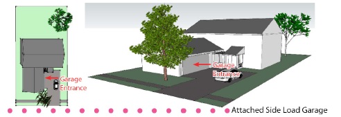
(3) Garage location/orientation. Two-car garages, a minimum of 22 feet in width, or 20 feet in width with an additional four-foot-deep by eight-foot-long storage area (within the garage), shall be required for all dwellings. Garages may be front-loading, side-loading, courtyard-loading, rear-loading, and/or detached. Any front-loading garage, attached or detached, which is located less than 20 feet behind the front elevation of the home, shall feature a decorative garage door. Any front-loading garage that protrudes eight feet or more in front of the front elevation, shall feature at least one window on each side elevation of the garage. These windows shall not count towards any other window requirement. No front-loading garage shall protrude more than ten feet in front of the front elevation. Garage protrusion shall be measured by determining the distance between the farthest protruding front facade of the garage and the widest portion of the front facade of the front elevation. Front-loading garages shall not exceed 45% of the width of the front elevation. Detached garages must be separated from the primary structure a minimum of ten feet. For any three-car or larger garage that faces a street, at least one of the bays must have a separate door and be off-set a minimum of two feet from the other bays. At least 25% of all lots within a residential subdivision shall feature a home that does not have a front-loading garage. All decorative garage doors shall be approved by the Architectural Review Committee. These regulations do not apply to multi-family residential developments.
Figure 1: Attached Front Load Garage A
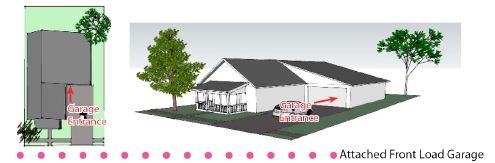
Figure 2: Attached Front Load Garage B
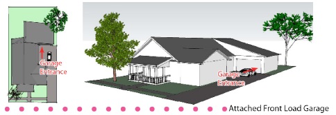
Figure 3: Detached Front Load Garage
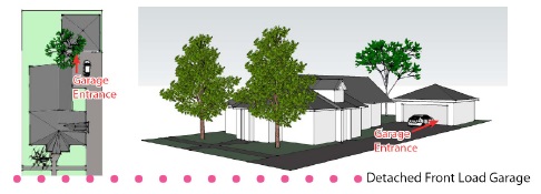
Figure 4: Detached Rear Load Garage
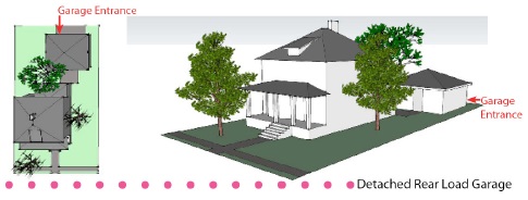
Figure 5: Attached Side Load Garage A
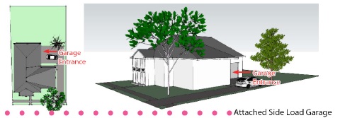
Figure 6: Attached Side Load Garage B
(Ord. 121410, passed 1-11-2011; Ord. 111114, passed 11-11-2014)