Special overlay districts are intended to be superimposed over the underlying general zoning districts and the land within each overlay district may be used in ways that achieve the objectives of each overlay district. Wherever standards of the underlying zoning district differ from the overlay standards, the more restrictive provisions shall apply.
2.06.1 DOWNTOWN OVERLAY DISTRICT
A. Purpose
The DOD District is established as an overlay in the areas located within and abutting the CB zoning district. This district is intended to:
1. Establish an area with greater land use flexibility than the CB and adjoining zoning districts;
2. Foster compatible land use transitions between the CB development and abutting residential neighborhoods;
3. Promote compatible design transitions in blocks facing or adjacent to the DOD; and
4. Provide safe and convenient connectivity between the downtown and nearby neighborhoods for bicyclists, pedestrians and motorists.
B. Area of Applicability
The area affected by the DOD are those lands in the "Main Street-Downtown" area as indicated on the Official Zoning Map.
C. Specific Development Standards
Dimensional and density standards shall comply with the underlying base district and other applicable standards except that:
1. The minimum height of buildings in areas with CB base zoning shall be two stories. The maximum is four stories (may exceed with a conditional use permit).
2. There shall be a minimum of 60% primary street lot frontage build out on properties.
3. For properties fronting on Main Street with CB base zoning, one of the following shall be provided along the frontage to provide and continue the "shop-front" design of downtown Lillington:
a) Shopfront & Awning: The façade is aligned close to the property line with building entrance at sidewalk grade. Substantial glazing on sidewalk level is provided and an awning that may overlap the sidewalk to the maximum extent possible.
b) Gallery: The façade is aligned close to the property line with an attached cantilevered roof or lightweight colonnade overlapping the sidewalk.
c) Arcade: A colonnade supporting habitable space aligned close to the property line, while the façade at sidewalk level is set back to create a sheltered pedestrian area.
2.06.2 URBAN RESIDENTIAL OVERLAY DISTRICT
A. Purpose
To promote development that reflects the town's character and is compatible with established surrounding residential neighborhoods. Infill development in this area is encouraged where infrastructure is readily available and that is designed to be complementary with surrounding established residential neighborhoods.
B. Area of Applicability
1. The following standards are applicable to all structures surrounding the DOD as illustrated on Official Zoning Map.
2. Single-family dwellings, duplexes & townhomes subject to regulation under the North Carolina Residential Code for One and Two Family Dwellings shall be subject to all provisions in this section except "3.c.i - Building Frontages" as listed below.
3. "3.c.i - Building Frontages" and additional residential building design standards may be applied to single-family dwellings, duplexes & townhome structures upon consent by the owner at the time of zoning, preliminary subdivision plat, or site plan approval.
C. Specific Development Standards
1. Infill Lot Standards: The minimum front or street yard required may be reduced for any lot where the average established front yard on developed lots located within 300 feet on each side of such lot, and fronting on the same street as such lot, is less than the minimum required yard. In such cases, the minimum front or street yard may be less than that required but not less than the average of the existing front yards on the developed lots within 300 feet of each side. In addition, for new lots created from existing larger lots, the lot width at the frontage line and the side yard setbacks shall be consistent with the immediately adjacent neighboring parcels on the same side of the street.
2. Lots less than 50 feet in width: One driveway of no more than 12 feet in width may be used to provide access to garages or off-street parking areas. Garages or off-street parking areas shall be located in the side or rear setback area only.
3. Development patterns: All development subject to this overlay district should be compatible with the established architectural character of the town by using a design that is complementary to existing town architectural styles, designs, and forms. As a means to provide guidance for the design of buildings that integrate well into the context of the town, this article has identified five key features necessary to ensure compatibility.
a) Street Frontage: Along residential side streets, limit interruptions to front setback landscaping. A key way of achieving this is by preserving existing front yard landscaping and minimizing the amount of frontage devoted to paved vehicle areas. | 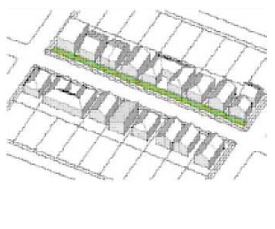 | 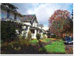 |
b) Rhythm of Development Along Street: Continue established building rhythms along street frontages. Avoid monolithic massing that disrupts fine-grain neighborhood or mixed-use corridor pattern. | 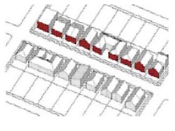 | 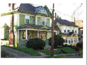 |
c) Building Frontages: i. Along street frontages, orient windows, main entrances, and other primary building façade elements toward the street. ii. Care should be taken to avoid the appearance of buildings turning their backs or sides toward the street. Courtyard buildings can contribute to this by orienting main entrances toward courtyards that serve as a semi-public extension of the public realm of adjacent streets. | 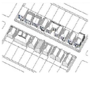 | 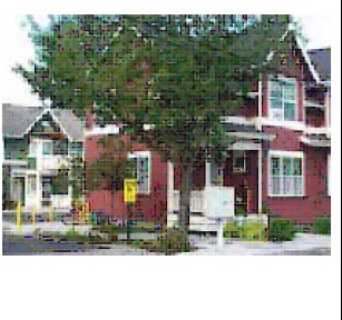 |
d) Front Setback Patterns: Continue established building setback patterns, where this is a neighborhood priority and is practical. | 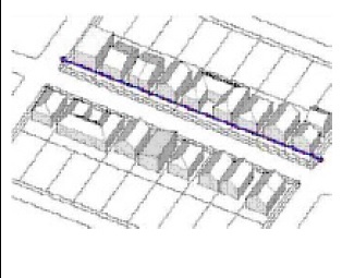 | 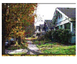 |
e) Use of Landscaping & Trees: Use landscaping and trees to achieve compatibility in areas where these are unifying elements of community character. | 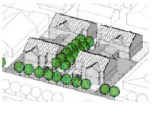 |  |
*Image source: A Guide to Infill Development & Infill Design Toolkit; City of Portland Bureau of Planning
2.06.3 HOD - HIGHWAY OVERLAY DISTRICT
A. Purpose
It is the intent of the Highway Overlay District to protect natural resources, provide landscape improvements, and enhance the overall appearance of the corridors identified. This district has development standards established to regulate development within a corridor. Development standards from the Highway Corridor Overlay District apply to all parcels within 500 feet of the right-of-way on both sides of the streets as shown on the Official Zoning Map. In cases where a portion of a tract of land lies within the Highway Overlay District, the entire tract shall fall into the same regulation. This overlay district is established to:
1. Prevent unsightly conditions that may destroy or detract from the natural character, beauty and condition;
2. Establish standards as may be necessary to accomplish the objective;
3. Minimize potential safety hazards that may exist along the roadways in the town; and
B. Area of Applicability
Major highway corridors affected by the HOD are U.S. 421, U.S. 401, NC 27 and NC 210, the boundaries of which are shown on the Official Zoning Map.
C. Exemptions
For master-planned community projects that are zoned RMX or NMX and over 250 acres in size, the applicant may be exempted from these standards when customized architectural, design and landscaping standards are established through the conditional zoning process.
D. Specific Development Standards
1. Architectural Standards
See Article IV – Design Standards.
2. Parking Lot (off-street parking) Landscaping
a) Parking lots, loading areas, and other vehicle use areas shall be planted with one tree and two shrubs for every ten parking spaces required.
b) At least 65% of the required parking lot trees shall be large shade trees.
c) Trees and shrubs shall be planted within 15 feet of the vehicle use areas.
d) Developments containing 30 or more parking spaces, 50% of the trees and shrubs required shall be planted in islands or medians located within the parking lot.
e) A consecutive strip of parking spaces shall include landscape islands every 20 spaces apart and at the ends of all parking rows.
f) Landscape islands shall be grassed and mowed, covered with organic material (for example, pine mulch), or a combination of the two.
g) In calculating the number of trees and shrubs, standard rounding procedures shall be followed. (For example, one and a half or greater will become two.
3. Driveways:
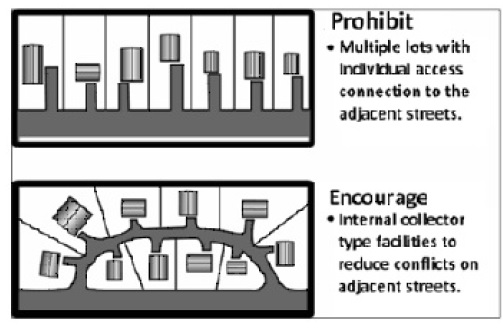
Driveways serving a new development parcel shall be permitted in accordance with the standards of the NCDOT; however, the Board of Commissi oners may require stricter standards as conditions of approval during the site plan review, if it is determined that the additional conditions may improve traffic movement and safety. Developers of nonreside ntial uses are required to share parking areas and driveways with adjoining developm ents. Also, no landscaping or structures shall be allowed near the intersections of driveways and streets that would impede safe vision of traffic. Subdivision of land with multiple smaller parcels having frontage on the roadway along the corridor will not be allowed. NCDOT and the town prohibit this type of development within the corridor. Development will be required to have shared access to the
roadway as approved by the NCDOT and the town.
4. Outdoor Storage: Outdoor storage, when permitted, shall be screened from view so that it is not visible from a right(s)-of-way or adjacent property(s). Any accessory outdoor storage area shall comply with the requirements set forth in this ordinance.
5. Outdoor Advertising Signs: No outdoor advertising signs shall be allowed within the Highway Overlay District or on any property(s) that are partially located within the Highway Overlay District, except in compliance with Article IV.
2.06.4 WPOD - WATERSHED PROTECTION OVERLAY DISTRICT
A. Purpose
Pursuant to requirements of G.S. § 143-214.5, two Watershed Protection Overlay Districts have been established for lands within the Cape Fear River watershed. This watershed is classified as a Water Supply IV which the state classifies as waters used as sources of water supply for drinking, culinary, or food processing purposes. These waters are generally in moderately to highly developed watersheds or protected areas.
B. Area of Applicability
To carry out the above purposes, the town has designated two overlay districts, the boundaries of which are shown on the Official Zoning Map.
1. CF-WPOD-CA – Cape Fear Watershed Protection Overlay District – Critical Area;
2. CF-WPOD-PA – Cape Fear Watershed Protection Overlay District – Protected Area.
C. Specific Development Standards
See Article VI – Environmental and Natural Resource Protection.
(Ord. passed 2-14-2017; Ord. 2022-06, passed 7- 13-2021)