(A) General requirements. The Commission shall not recommend for approval any subdivision plat which does not make adequate provision for storm or flood water runoff channels or basins. The storm water drainage system shall be separate and independent of any sanitary sewer system. Surface water drainage patterns shall be shown for each and every lot and block. The system must meet the following standards:
(1) A storm water sewer system or a surface drainage system designed for not less than a five-year storm frequency to serve the area being subdivided shall be provided;
(2) When curbs and gutters are provided or when the Commission determines the natural surface drainage to be inadequate, the subdivider shall construct a storm water sewer system with inlets appropriately spaced in the subdivision;
(3) A natural surface drainage system shall be permitted when curbs and gutters are not provided, and the natural drainage will, in the opinion of the Commission, adequately drain the storm water from the subdivision. The drainage ways should be shallow swales sowed in grass rather than deep, open ditches. Streets not having curb and gutter shall provide the following:
(a) Side ditch swales constructed at one foot (vertical) to three feet (horizontal);
(b) A swale or culvert at all driveways sized according to the amount of storm water flow;
(c) Culverts under the roadway where necessary: the size of culverts will be according to the amount of storm water flow, but will not be less than 12 inches in diameter; and
(d) Relief of side ditches and swales along the roadway through the use of off-street detention basins or existing drainage channels. Detention basins may be required to avoid overloading channels and ditches.
(4) When topsoil has been removed from the surface of a lot on a slope where erosion will cause a displacement of loose materials, the subdivider shall utilize approved methods to prevent the wash from damaging adjacent property, accumulating on street surfaces, or blocking drainageways; and
(5) In the design of a storm water sewer system for a subdivision, the present and future expected runoff from the larger drainage area shall be considered. For this reason, it may be desirable that larger sewers than those needed to service the immediate subdivision be installed, if this occurs, the Commission may recommend that the public utility join with the subdivider in the installation of the sewer system.
(B) Nature of storm water facilities.
(1) Location. The applicant may be required by the Commission to carry away by pipe or open ditch any spring or surface water that may exist, either prior to, or as result of the subdivision. The drainage facilities shall be located in the street right-of-way where feasible, or in perpetual, unobstructed easements of appropriate width, and shall be constructed in accordance with the city's and/or county's construction standards and specifications.
(2) Accessibility to public storm sewers.
(a) Where a public storm sewer is accessible, the applicant shall install storm sewer facilities, or if no outlets are within a reasonable distance adequate provision shall be made for the disposal of storm water, subject to the specifications of the City Engineer. However, in subdivisions containing lots of less than 15,000 square feet in area and in business and industrial districts, underground storm sewer systems shall be constructed throughout the subdivision and be conducted to an approved outfall. Inspection of facilities shall be conducted by the City Engineer.
(b) If a connection to a public storm sewer will be provided eventually, as determined by the City Engineer and the Commission, the developer shall make arrangements for future storm water disposal by the public utility system at the time the plat receives final approval. Cost provision(s) for the connections) shall be incorporated by inclusion in the amount of the performance bond or equivalent required for the subdivision plat.
(3) Accommodation of upstream drainage areas. A culvert or other drainage facility shall in each case be large enough to accommodate potential runoff from its entire upstream drainage area, whether inside or outside the subdivision. The City and/or County Engineer shall determine the necessary size of the facility, based on the provisions of the required construction standards and specifications assuming conditions of maximum potential watershed development permitted by the Zoning Ordinance.
(4) Effect on downstream drainage areas. The City and/or County Engineer shall determine the effect of each proposed subdivision on existing drainage facilities outside the area of the subdivision. City and/or county drainage studies together with other studies as may be available and appropriate, shall serve as a guide to needed improvements. Where it is anticipated that the additional runoff incident to the development of the subdivision will overload an existing downstream drainage facility, the Commission may withhold secondary approval of the subdivision until provision (such as a storage facility) has been made for file improvement of the potential condition in a sum as the Commission shall determine. No subdivision shall be approved unless adequate drainage from it will be provided to an adequate drainage water course or facility.
(5) Areas of poor drainage. Areas which are not in the flood plain but contain soils which are subject to flooding may be approved for subdivision by the Commission, provided that the subdivider fills the affected areas of the subdivision to an elevation sufficient to place building sites and streets two feet above ponding levels.
(6) Areas of high seasonal water tables. In areas characterized by soils having a high seasonal water table as determined by the County Soil and Water Conservation District, lots shall be limited to slab type construction unless the Commission determines that appropriate engineering techniques will be applied to alleviate the subsurface problem.
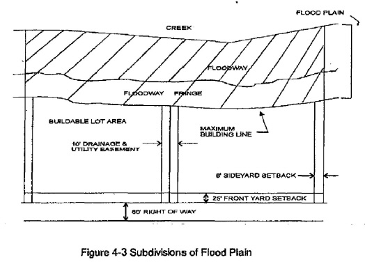
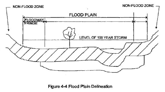
(7) Floodway areas. If a subdivision of land is proposed within the flood plain, floodways shall be preserved and not diminished in capacity by filling or obstruction, except as approved by the Natural Resources Commission in writing. No residential building site may be located within the floodway. See Figures 4-3 and 4-4 in division (B)(10) below.
(8) Floodway fringe areas. Where a subdivision is proposed within an area of the flood plain designated as a floodway fringe, the Commission may approve the subdivision provided that: all streets are elevated sufficiently to be above the regulatory flood elevation; all lots for residential usage have a flood protection grade two feet above the regulatory flood elevation; where provided, water and sanitary sewer facilities are constructed to eliminate contamination of or by, flood water; and, approval to fill the area from the Natural Resources Commission has been obtained in writing. Lands below the regulatory flood elevation shall not be used for computing the area requirement for any lot. See Figures 4-3 and 4-4 in division (B)(10) below.
(9) Flood plain areas. Where a subdivision is proposed within an area of the flood plain for which floodway and floodway fringe designations have not been made, the Commission shall not approve such a subdivision unless all streets are raised sufficiently to be above the regulatory flood elevation; all lots for residential usage have a flood protection grade of two feet above the regulatory flood elevation; where provided, public water and sanitary sewer facilities are constructed to eliminate contamination of or by flood water; and, filling to achieve the above will not raise the level of the regulatory flood elevation more than one-tenth of one foot for that reach of the stream. All filling in the flood plain must be approved in writing by the State Natural Resources Commission. Lands below the regulatory flood elevation shall not be used for computing the area requirement for any lot.
(10) Recording of plats in the flood plain and floodway fringe. All final plats having within their boundaries areas whose elevation is below that of the regulatory flood elevation shall show and label the regulatory flood boundary and elevation, as of the date the final plat is drawn, on the final plat for recording.
(C) Dedication of drainage easements.
(1) General requirements. Where a subdivision is traversed by a drainage course, drainage way, channel or stream, a storm water easement or drainage right-of-way shall be provided, granted or dedicated to the city and/or county, conforming substantially to the lines of the watercourse, and of a width and construction or both as will be adequate for the purpose of both drainage and maintenance of the right-of-way. Wherever possible, it is desirable that the drainage be maintained by an open channel with landscaped banks and adequate width for maximum potential volume of flow.
(2) Drainage easements.
(a) Where topography or other conditions are such as to make impractical the inclusion of drainage facilities within street rights-of-way, perpetual unobstructed easements at least 15 feet in width for the drainage facilities shall be provided across property outside the right-of-way lines and with satisfactory access to the street. Easements shall be indicated on the plat. Drainage easements shall be carried from the street to a natural watercourse or to other drainage facilities.
(b) The applicant shall dedicate, either in fee or by drainage or conservation, easement land on both sides of existing watercourses of a width to be determined by the Commission and, in the case of legal drains, the County Drainage Board.
(c) When a proposed drainage system will carry water across private land outside the subdivision, appropriate drainage rights must be secured and indicated on the plat.
(d) Low-lying lands along watercourses subject to flooding or overflowing during storm periods, whether or not included in areas for dedication, shall be preserved and retained in their natural state as drainage ways. The land or lands subject to periodic flooding shall not be included in the computations for determining the number of lots allowable under average density procedures nor for computing the area requirement for any individual lot.
(Ord. 615, passed 2-22-1999)