(A) Intent.
(1) The intent of these regulations is to preserve the scenic and natural resource values of shorelines and river and stream banks within the village.
(2) More specifically, the purposes of this Overlay District are to:
(a) Promote public health, safety, and general welfare;
(b) Encourage the use of natural resources in the village in accordance with their character and adaptability;
(c) Preserve and maintain the scenic views of shorelines and river and stream banks;
(d) Establish the location and size of waterfront structures which may hereafter be erected or altered; and
(e) Provide rules and regulations for the construction of such waterfront structures.
(3) These regulations shall apply to all zoning districts in the village which extend into, abut, or are adjacent to lakes and navigable waterways in the village. This Overlay District regulates the construction of waterfront structures and appurtenances proposed along, abutting upon, or extending into lakes and navigable waterways in the village.
(B) Permitted uses.
(1) Principal uses are identified by each separate zoning district.
(2) (a) Waterfront structures and appurtenances are permitted accessory uses to the principal use permitted in zoning districts within the Waterfront Overlay District.
(b) They are permitted for recreational and personal use of the principal user (occupant) and family members residing with the principal user of the property. No structure will be approved without an existing principal structure on the parcel.
(3) Applications to construct all waterfront structures and appurtenances shall be subject to review and approval procedures outlined in division (D) below.
(C) Waterfront requirements.
(1) Water-related structures and appurtenances. The following structures and appurtenances shall be permitted, subject to the conditions in division (C)(2) below:
(a) Piers and docks, including floating types;
(b) Boat hoists, davits, or mooring whips;
(c) Spring or mooring piles, ice cluster; and
(d) Enclosed or unenclosed boat port/wells not exceeding a height of one story or 15 feet above mean high water.
(2) Standards for water-related structures and appurtenances. The above structures and appurtenances shall be constructed to meet the following conditions.
(a) Individually or collectively, the structure(s), appurtenance(s), and dock(s) shall not be closer than six feet to a side lot line.
(b) Construction or installation of structures and appurtenances shall not obstruct the access of boaters to:
1. Adjoining or nearby parcels;
2. Normal boating routes; or
3. Obstruct the natural flow of water.
(c) No bulkheads shall be constructed which shall extend into the waterway.
(d) A maximum of two covered unenclosed boat ports/wells and a maximum of two out of water-lifting devices are permitted per site and shall be designed and constructed as a unit.
(e) All permitted structures and appurtenances set forth in division (C)(1) above shall be kept safe, secure, and in good repair.
(3) Number of boats and structures.
(a) The allowable accessory use of the waterfront shall be limited to not more than one boat for every 33 feet of water frontage to a maximum of three boats. For the purposes of this chapter, a BOAT shall mean any water craft equipped with a motor or engine.
(b) The number of structures covered in this division (C) is limited to the extent they serve the number of boats permitted in division (C)(3)(a) above, except for covered boat ports/walls and lifting devices which are otherwise limited to a maximum of two by division (B)(2) above.
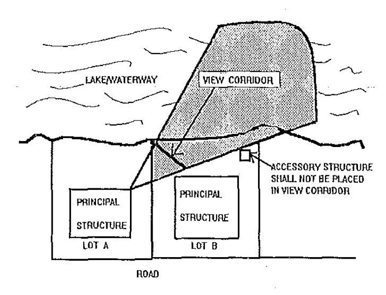
(4) Waterfront yards and accessory structures. Accessory structures shall be permitted in yard areas as allowed by § 157.035, subject to the following condition: the placement of the accessory structure shall not obscure the view corridor across the yard of the subject lot to open water from any adjoining residence. This standard is diagramed below.
(5) Shoreline fill, dredging, and construction of seawalls.
(a) Application for shoreline fill or construction of seawalls shall be referred to the State Department of Natural Resources for any necessary permits.
(b) Additionally, such activities must meet the following standards, except as modified by any required state or county permit.
1. In no case shall shoreline fill, dredging, or construction of seawalls impede the natural flow of water or obstruct the access of boaters to deeper waters.
2. No seawall or fill shall project beyond an existing seawall or shoreline in such a manner as to interfere with the normal flow of water, result in the deposit of debris, or cause a hindrance to navigation.
3. Proposed fill shall avoid the appearance of being added on. Any extension of land shall blend into the existing shoreline in a natural appearing manner.
4. Prior to final inspection for shoreline filling or construction of seawalls, the land shall be graded and seeded so as to provide proper drainage within the applicants property, away from buildings. The grade must be established within 90 days of the completion of construction.
(D) Application and review procedures. Applications to construct accessory structures, waterfront structures and appurtenances, to fill along the shoreline or to construct, repair, or demolish a seawall shall be subject to the following review procedures.
(1) Waterfront application.
1. Existing seawalls, waterfront structures, and appurtenances on the property and structures adjacent to the applicant’s property;
2. Cross-sections and topography at two-foot contour intervals which show the existing and proposed topography of waterfront land, the depth of water along the shore, the relation of existing rights-of-way for free passage of watercraft on waterways, and the relation of proposed grades to adjoining property;
3. Designation of all property lines along with the method used to verify the location of the property lines;
4. Quantities and type of shoreline fill materials, if proposed;
5. Time frame for completion of the project; and
6. For proposed waterfront uses or activities involving the use, storage, handling, or processing of hazardous or toxic materials in excess of 25 gallons or 250 pounds, the applicant shall submit a written statement describing measures to prevent groundwater and surface water contamination caused by accidental spills or leakage.
7. Such measures may include, but not be limited to, special check valves, drain back catch basins, and automatic shut- off valves, as approved by the Fire Department.
8. Such measures also may include a location of the proposed use or facility where accidental spills are not as likely to contaminate surface or groundwater.
9. For the purposes of this section, hazardous or toxic materials shall include materials listed as SARA Title III, being 42 U.S.C. §§ 11004, materials by the State Department of Natural Resources.
(2) Review procedure.
(a) The Zoning Official shall approve an application that meets all village requirements and issue a permit, except that the Planning Commission and/or Zoning Commission, as required, shall have full jurisdiction concerning applications where Planning Commission and/or Zoning Commission, as required, review is required by this chapter.
(b) In the event the Planning Commission and/or Zoning Commission, as required, is required to review and act on an application for waterfront development, the Planning Commission and/or Zoning Commission, as required, shall conduct such review in accordance with the normal procedures for review and approval as outlined in §§ 157.190 to 157.204, “Site Plan Review and Approval”.
(E) Additional site development standards. All permitted and special land uses shall comply with all applicable provisions of this chapter, including those listed below as a reference guide:
(2) Sections 157.025 through 157.057, “General Regulations” for standards on a variety of items such as: calculation of buildable lot; regulations for single-family dwellings; illegal dwellings; accessory uses, temporary buildings, and structures; parking and repair of vehicles; swimming pools; fences; reception antennas; limitations on clearing and grading site; and the like;
(3) Section 157.009, “schedule of regulations” (minimum lot area, lot width, setbacks, maximum height, and the like);
(Ord. 259, passed 10-24-1995; Ord. passed 2-1-2012) Penalty, see § 157.999