A. Purpose: To promote landscaping in unincorporated Gem County that will improve community livability, preserve the quality of life, and enhance the aesthetic quality, economic viability, and environmental health and safety of the county.
B. Costs To Developers And Property Owners: Gem County recognizes that landscaping can be a significant expense to businesses, developers, and residents. At the same time, landscaping improves the livability of residential neighborhoods, enhances the appearance and customer attraction of commercial areas, increases property values, improves the compatibility of adjacent uses, screens undesirable views, and can reduce air and noise pollution. The intent of these regulations is to achieve a balance between the right of individuals to develop and maintain their property in a manner they prefer and the right of county residents to live, work, shop, and recreate in pleasant, healthy, and attractive surroundings.
C. Definitions: For the purpose of this section, the following terms shall have the meanings ascribed to them below:
BERM: An earthen mound designed to provide visual interest, screen undesirable view, and/or decrease noise.
BUFFER: A combination of physical space and vertical elements, including, but not limited to, trees, shrubs, berms, fences and/or walls that separate and screen incompatible land uses from one another.
CALIPER: A measurement of the diameter of the trunk of a deciduous tree. The caliper of the trunk shall be measured six inches (6") above the ground for all trees up to and including four inch (4") caliper size and twelve inches (12") above the ground for larger sizes.
CASH ESCROW: Cash or certified check submitted to the clerk of the district court for incomplete landscape improvements to secure a temporary certificate of occupancy. The money will be refunded when the improvements are deemed to be in accordance with the approved landscape plan.
CERTIFICATE OF OCCUPANCY: Official certification that a building and site conform to the provisions of county ordinance and any other appropriate conditions such as a development agreement, and/or special use permit. A structure cannot be occupied without issuance of a certificate of occupancy.
CLASS I, II, III TREES: The classes of trees are defined for the purposes of this section by the publication "Tree Selection Guide For Streets And Landscapes Throughout Idaho" by urban forestry unit of Boise parks and recreation department (by the most recent publication). In general, class I trees are smaller ornamental trees, class II trees are medium/large trees appropriate for street tree planting, and class III trees are very large.
ENTRYWAY CORRIDORS: Arterial roadways that introduce both visitors and residents to Gem County as defined by the Gem County comprehensive plan.
GIRDLING: Damaging or removing the bark and cambium layer around a tree trunk in a manner that usually kills the tree.
GROSS LAND AREA: The total area of the land being developed, exclusive of required street buffers and buffers between incompatible land uses. The calculation for required open space in residential subdivisions and multi-family residential development is based on the gross land area of the land being developed.
HARDSHIP: An unusual situation on the part of an individual property owner which will not permit that owner to enjoy the full utilization of their property as is enjoyed by others in the community. A hardship can exist only when it is not self-created.
HEAD TO HEAD SPACING: Placement of sprinkler heads in a rectangular pattern such that one sprinkler head sprays to the next (spacing is 50 percent of the sprinkler's spray diameter). For design flexibility, maximum spacing is up to sixty percent (60%) of the sprinkler's spray diameter. Where winds are a threat, spacing up to forty percent (40%) may be desirable.
IMPERVIOUS SURFACE: A surface that has been compacted or covered with a layer of material so that it is highly resistant to infiltration of absorption by water. It includes surfaces such as compacted sand or clay as well as most conventionally surfaced streets, roofs, sidewalks and parking lots.
INFILL: Any vacant lot or parcel within developed area of the county, where at least eighty percent (80%) of the land within a three hundred foot (300') radius of the site has been developed, and where water, sewer, streets, schools and fire protection have already been developed and are provided.
LETTER OF CREDIT: A letter issued by a bank or other guaranteed financial institution authorizing Gem County to draw a stated amount of money from the issuing bank under specific, stated conditions.
MATCH LINES: A heavy line shown on a plan when it is separated onto two (2) or more sheets. The lines are labeled the same on each sheet to depict where the sheets join.
MATCHED PRECIPITATION RATES: Sprinklers that are designed to work together on the same irrigation valve to deliver an equivalent rate of water application, regardless of the arc of the nozzle being used.
MICROPATH: A pathway providing access by way of a short travel link between points of destination. The length of a micropath is less than two hundred fifty feet (250'), or two (2) lot depths, and must have a minimum of ten feet (10') width of paved surface.
MITIGATION: An action that will moderate or alleviate the actual or potential loss of benefits provided to a site and its immediate vicinity by existing trees and landscaping.
MULCH: A protective covering placed around plants to prevent the evaporation of moisture, the freezing of roots, and the growth of weeds.
PARKING LOT OVERLAY: Any resurfacing of existing parking lot areas with asphalt or other permanent material. No increase in the square footage of the parking area may result.
PARKING LOT REPLACEMENT: Removal of the existing parking surface done for the purpose of improvement or repair.
PARKWAY: Landscaped area located between the edge of a street section or curb and a sidewalk dedicated to separate pedestrian and vehicular traffic. The intent is to increase pedestrian use and safety and to improve the visual aesthetics and environmental quality of roadways.
RESTRIPING (PARKING LOT): Any change in the configuration, size or distribution of existing painted stripes designed to create spaces for motorized vehicles.
SIGHT TRIANGLE: The area on either side of an accessway at its junction with a street forming a triangle within which clear visibility of approaching vehicular or pedestrian traffic shall be maintained.
SOIL STABILIZATION: The state of having sufficient vegetation and gradual slopes to prevent soil erosion and sedimentation onto adjacent features such as sidewalks, driveways, parking areas, lawns, or water bodies.
STORMWATER SWALE: A broad, shallow channel covered with erosion resistant vegetation and used to conduct, infiltrate, and pretreat surface runoff. Maximum slopes are three to one (3:1).
TOPPING: Severely cutting back limbs to stubs within the tree's crown to such a degree as to remove the normal canopy and disfigure the tree. Good pruning practices rarely remove more than one-fourth (1/4) to one-third (1/3) of a tree's crown. Topping starves the tree of needed nutrients produced by leaves in the crown, increases vulnerability to insects and disease, creates weak limbs, rapid new growth, and disfigures the natural shape of the tree. Other common terms for topping include "stubbing", "heading", "heading back", "stubbing off", "tipping", "lopping", or "round over". All forms of topping are prohibited by this section.
TRIANGULAR SPACING: Placement of sprinkler heads in an equilateral triangular pattern. The distance between heads in each row must be "head to head spacing" as per the definition in this section. The distance between rows is 0.866 times the spacing within the row.
UNIMPROVED NATURAL FEATURES: Existing wetlands, rock outcroppings, groves of trees, and other naturally occurring features may be left undeveloped in their natural state and may be counted as open space with approval of the administrator.
D. Landscape Plan:
1. Applicability: A landscape plan and landscape improvements are required for all commercial, industrial, office, and multi-family development, redevelopment, additions, or changes in use. A landscape plan and landscape improvements are also required for all common lots in all R zone residential subdivisions within the area of city impact on all applications for preliminary plats (PP) and final plats (FP). A landscape plan may also be required for uses that vary from the intended character of the surrounding properties as part of the special use permit (SUP) application process. The landscape plan may be on the same site plan used to show parking layout, setback compliance, etc. A preliminary landscape plan review is recommended prior to submission for all developments, but is not required.
2. Submittal Requirements: All landscape plans shall comply with the requirements for size, scale, number of copies, and contents as detailed in the application form.
3. Landscape Plan Preparation: Preparing a landscape plan requires special skills. Landscaping involves more than a simple arrangement of plants with irrigation; plants are not haphazardly placed in a way that fills up leftover space. Landscape plans should be artfully and technically organized in a way that conveys coherence, design, and organization. The landscaping should enhance the physical environment as well as the project's aesthetic character. Also, requiring plans prepared by a landscape professional minimizes the likelihood of trees dying or interfering with other adjacent site features. Therefore, all landscape plans proposed for a large scale development or along any entryway corridor shall be prepared by a landscape architect, landscape designer, or qualified nurseryman.
4. Landscape Plan Modification: The approved landscape plan shall not be altered without prior approval of the administrator. No significant field changes to the plan are permitted. Prior written approval of all material changes is required. All approved changes to the landscape plan must be documented prior to issuance of a certificate of occupancy.
E. Minimum Design Standards And Installation:
1. Approved Plant Material: The publication titled "Tree Selection Guide For Streets And Landscapes Throughout Idaho" by the urban forestry unit of the Boise parks and recreation department (latest edition) is hereby adopted by this reference as the Gem County list of approved and prohibited plant material. The publication categorizes the trees by size as class I, class II, or class III trees. The county recognizes that new plant varieties are being produced every year and will consider other species not listed in the publication. Copies of the publication will be available at the planning and zoning department.
2. Prohibited Plant Material: The plants listed under "trees not permitted for rights of way property planting" are prohibited from being planted along any street or within any parking lot regulated by this section. The only exception is that conifers may be planted in street buffers around residential subdivisions, and in buffers along Highway 16 and Highway 52.
3. Minimum Plant Sizes: The following are minimum plant sizes for all required landscape areas:
Shade trees | 1
1/2 inch caliper minimum |
Ornamental trees | 11/4 inch caliper minimum |
Evergreen trees | 4 - 5 foot height minimum |
Woody shrubs | 2 gallon pot minimum |
4. Tree Species Mix: When five (5) or more trees are to be planted to meet the requirements of any portion of this section, including street trees, street buffers, parking lot landscaping and other landscape guidelines, a mix of species shall be provided. The number of species to be planted shall vary according to the overall number of trees required to be planted. See table below:
Required Number Of Trees | Minimum Number Of Species |
5 – 10 | 2 |
11 – 30 | 3 |
31 – 50 | 4 |
50+ | 5 |
5. Plant Quality: All plant material installed pursuant to this section shall meet or exceed the minimum federal standards as regulated by ANSI Z60.1, American standard for nursery stock.
6. Planting Standards: All trees, shrubs, and other plant material shall be planted using accepted nursery standards as published by the American Association Of Nurserymen (latest edition) including hole size, backfilling, and fertilization.
7. Staking: Tree staking may be used in areas with high winds or other situations that make staking desirable. When trees are staked, the stakes must be removed within twelve (12) months to prevent damage to the tree.
8. Mulch: An organic mulch such as bark or soil aid shall be applied to all planting areas for moisture retention, weed control, and moderation of soil temperatures. Impermeable plastic weed barrier is prohibited under the mulch, because it restricts water and oxygen to the roots. Gravel/rock mulch is prohibited in required landscape areas as per subsection E13b of this section.
9. Curbing: All planting areas that border driveways, parking lots, and other vehicular use areas shall be protected by street curbing, wheel stops, or other approved protective devices. Such devices shall be a minimum of thirty inches (30") from all tree trunks to prevent cars from damaging tree trunks.
10. Utilities: The following standards apply to the planting of trees near existing utilities and to trenching for new utilities near existing trees:
a. Overhead Utilities: Only class I trees in the recommended plant list may be planted under or within ten (10) lateral feet of any overhead utility wires.
b. Underground Utilities: All trees shall be planted outside of any easement that contains a power, water or sewer main, unless written approval is obtained from the county engineer. If any utility easement precludes trees required by this section, the width of the required buffer shall be increased to accommodate the required trees.
c. Trenching: New underground utilities shall stay outside of the drip line of existing trees if trenched, or be tunneled a minimum of three feet (3') below existing grade within the tree's drip line. The guiding principle is that no root two inches (2") or larger shall be cut. Note: This requirement is for placement of new utilities and does not affect the property owner's ability to access existing utilities for repair and maintenance.
11. Erosion Control: Soil and slope stabilization shall result from the landscape installation.
12. Berms: Berm slopes shall not exceed three to one (3:1) (horizontal to vertical). Three to one (3:1) maximum slopes are recommended. Grass that requires mowing shall not be used on slopes steeper than three to one (3:1).
13. Water Efficiency: The landscape plan shall provide for water efficient landscaping as follows:
a. Lawn Areas: Where appropriate, and on sites where other landscape options can be incorporated, large expanses of lawn are discouraged due to its high water consumption.
b. Mulch: Mulches shall be organic and broad uses of gravel/rock mulch are restricted as per subsection E8 of this section. Gravel does not retain water, reflects heat, and causes greater stress on trees and shrubs. Organic mulch retains water for a longer period of time for plants.
c. Irrigation: Irrigation systems shall be designed for water efficiency as regulated by subsection F of this section.
d. Native Plants: Native and other low water use plants are encouraged. The approved plant list as per subsection E1 of this section shows the general water requirements of the trees.
F. Irrigation:
1. Irrigation Required: All landscape areas regulated by this section shall be served with an approved irrigation system.
2. Performance Specifications: Three (3) copies of detailed irrigation performance specifications shall be submitted with the landscape plan for all final plats and certificates of zoning compliance. Performance specifications shall state design requirements, materials, and construction methods. At a minimum, the performance specifications shall address the following requirements:
a. Required Information: Specifications for the irrigation system shall include:
(1) Available gallons per minute;
(2) Available water pressure; and
(3) Point of connection.
b. Backflow Prevention: Provide an appropriate backflow prevention device.
c. Coverage: The irrigation system shall be designed to provide one hundred percent (100%) coverage with head to head spacing or triangular spacing as appropriate.
d. Matched Precipitation Rates: Sprinkler heads shall have matched precipitation rates within each control valve circuit.
e. Irrigation Zones: Sprinkler heads irrigating lawn or other high water demand areas shall be circuited so that they are on a separate zone or zones from those irrigating trees, shrubs, or other reduced water demand areas.
f. Overspray: Sprinkler heads shall be adjusted to reduce overspray onto impervious surfaces such as sidewalks, driveways, and parking areas.
3. Subdivision Irrigation Systems: If the irrigation system is part of a residential, commercial, or industrial subdivision, any irrigation pump station shall be on a common lot. Also, the irrigation system must be owned and maintained by an irrigation district or a homeowners' (or business owners') association.
G. Sight Triangles:
1. Sight Triangles: The following standards shall be observed within all sight triangles, both at controlled and uncontrolled intersections. In all cases, Idaho transportation department (ITD) and Gem County road department standards shall apply in addition to city of Emmett standards.
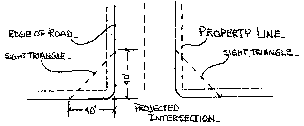
2. Road/Road Intersections: The boundaries of a sight triangle at the intersection of two (2) roads are defined by measuring from the projected intersection of the roadway edge a distance of forty feet (40') along each roadway edge and connecting the two (2) points with a straight line. (See diagram below.)
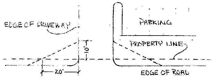
3. Road/Driveway Intersections: The boundaries of a sight triangle at the intersection of a road and a driveway are defined by measuring from the intersection of the property line and the edge of the driveway twenty feet (20') along the roadway and ten feet (10') along the driveway and connecting the two (2) points with a straight line. (See diagram below.)
4. Road/Railroad Intersections: The sight triangle at road/road intersections (see subsection G2 of this section) is also applicable to railroad/street crossings with the vision triangle defined by measuring forty feet (40') along the railroad property line and forty feet (40') along the roadway edge and connecting the two (2) points with a straight line.
5. Planting And Development Standards:
a. Any trees planted within sight triangles (class I or II) shall be pruned to a minimum height of eight feet (8') above the ground or sidewalk surface and fourteen feet (14') above the adjacent roadway surface.
b. No evergreen trees shall be planted within any sight triangle.
c. No class III trees shall be planted within any sight triangle.
d. The maximum height of any berm or vegetative ground cover at maturity within the sight triangle is three feet (3').
e. No fences higher than three feet (3') are permitted in the sight triangle.
f. No signs taller than three feet (3') are permitted in the sight triangle, except for street/stop signs approved by the Gem County road department.
6. Public Safety And Enforcement: When the county determines that a sight obstruction exists, it shall notify the owner of the property upon which the obstruction is located and order that the obstruction be removed within thirty (30) days. The failure of the owner to remove the obstruction shall be punishable as a misdemeanor, and every day the owner fails to remove the obstruction shall be a separate and distinct offense.
H. Street Buffers:
1. Purpose: Landscape buffers along streets are required in order to improve the visual quality of the streetscape, to soften the impact of parking lots, to unify diverse architecture, and to carry out the comprehensive plan policies related to promoting attractive roadways and street beautification.
2. Location: All required buffers shall be located beyond any street right of way and shall be maintained by the property owner, at the property owner's expense, upon which the buffer lies. All street buffers with attached sidewalks shall be measured from the property line and not from the sidewalk or curb. If detached sidewalks are provided as per subsection H8 of this section, the buffer may be measured from the back of curb when it can be demonstrated that there is no opportunity for expansion of the street section within the right of way; the buffer width must exclude the width of the sidewalk. No fences are permitted within required street buffers.
3. Applicability: Street buffers shall be required at all subdivision boundaries (i.e., commercial, industrial, high tech, and residential) and all commercial, industrial and high tech developments. Single-family residential, and duplex lots interior to or outside of a subdivision are exempt from required street buffers. Minor subdivisions shall not be required to provide buffers except those located in the area of city impact. All subdivision street buffers must be either on a common lot or within a landscape easement, maintained by a homeowners' or business owners' association, as applicable.
4. Buffer Size: The required width of the landscape buffer is calculated as follows: Note: Residential collectors do not have a required street buffer.
Street Type | Buffer Width |
Local road and minor collector (except in residential areas per subsection H3 of this section) | 10 feet |
Major collector | 20 feet |
State highway | 25 feet |
5. Width Reduction: In a development where the required street buffer width results in an otherwise unavoidable hardship to the property, a written request for a reduction may be submitted to the administrator. The request must demonstrate evidence of the hardship caused by the required street buffer and propose a specific alternative width. In no case shall the width be reduced to less than ten percent (10%) of the depth of the lot without a variance.
6. Street Trees: All required landscape street buffers shall be planted with trees and shrubs, lawn, or other vegetative ground cover, with a minimum density of one tree per thirty five (35) linear feet. If this calculation results in a fraction 0.5 or greater, round up to an additional tree. If the calculation results in a fraction less than 0.5, round the number down.
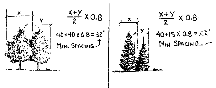
7. Tree Spacing: For design flexibility, trees may be grouped together or spaced evenly as desired. However, trees shall be spaced no closer than eighty percent (80%) of the average mature width of the trees, as demonstrated in the following examples:
8. Parkways And Detached Sidewalks: Sidewalks are required along all arterial streets in new developments at the edge (abutting) of existing city limits. The minimum width of the parkway area between the curb and the sidewalk is five feet (5'). Tree plantings within parkways less than ten feet (10') wide are restricted to class II trees. Existing developments and infill projects may waive the requirement for detached sidewalks to match surrounding conditions. If detached sidewalks are provided on local streets in residential subdivisions, the minimum sidewalk width may be reduced to four feet (4').
9. Impervious Surfaces: Allowed impervious surfaces include driveways, signs and walkways. Vehicle display pads and other related impervious surfaces are prohibited in the required street buffer.
10. Berms In Street Buffers: Berm design is subject to the provisions of subsections E12 and G5d of this section.
11. Stormwater Detention: Stormwater swales may be incorporated into the buffer as provided for in subsection L of this section. Other stormwater detention and retention facilities shall not be permitted in the street buffer.
I. Parking Lots:
1. Right Of Way Landscaping: A landscape buffer is required between all parking lots and adjacent streets as regulated by subsection H of this section.
2. Perimeter Landscaping: The following standards apply to all interior lot lines, side or rear, adjacent to parking lots or other vehicular use areas, including driveways:
a. Purpose: Perimeter landscaping defines parking, loading, and other vehicular use areas and prevents two (2) adjacent lots from becoming one large expanse of paving. This requirement does not hinder the ability to provide vehicular access between lots, nor does it prohibit commercial or industrial developments with back to back truck docks from sharing paved loading areas.
b. Size And Location: Provide a five foot (5') minimum perimeter landscape strip along all interior lot lines that are adjacent to parking, loading, or other paved vehicular use areas, including driveways, vehicle sales areas, truck parking areas, bus parking areas, and vehicle storage areas.
c. Landscaping: The perimeter landscape strip shall be planted with one tree per thirty five (35) linear feet and shrubs, lawn, or other vegetative ground cover.
3. Internal Landscaping: Interior parking lot landscaping shall be required on any parking lot with more than twelve (12) spaces.
a. Required Percentage: The required amount of landscaping is based on a sliding scale as follows:
Total Number Of Parking Spaces | Percent Of Total Area Of A Parking Lot That Must Be An Interior Landscaped Area |
13 – 100 | 4 |
101 – 200 | 6 |
201+ | 8 |
b. Planter Size: Landscape planters shall contain a minimum of fifty (50) square feet and the planting area shall not be less than five feet (5') in any dimension, measured inside curbs. The only exception to the five foot (5') minimum dimension is at the tip of triangular planters located at the end of rows of angled parking.
c. Parking Spaces: No linear grouping of parking spaces shall exceed fifteen (15) in a row, without an internal planter island.
d. Parking Lot Layout: Interior landscaping shall, insofar as possible, be used to delineate and guide major traffic movement within the parking area so as to prevent cross space driving. Interior landscape planters shall be spaced as evenly as feasible and at the ends of rows of parking throughout the lot to consistently reduce the visual impact of long rows of parked cars.
e. Trees Required: Each interior planter that serves a single row of parking spaces shall be landscaped with at least one tree and shall be covered with low shrubs, lawn, or other vegetative ground cover. Each interior planter that serves a double row of parking spaces shall have at least two (2) trees and shall be covered with low shrubs, lawn, or other vegetative ground cover. Deciduous shade trees must be pruned to a minimum height of eight feet (8') above the adjacent parking areas. Evergreen trees and class III trees are prohibited in interior planters.
f. Design Flexibility: In parking areas where the strict application of subsection I3a of this section will seriously limit the function and circulation of the lot, up to fifty percent (50%) of the required landscaping may be located near the perimeter of the paved area to emphasize entrance corridors or special landscape areas within the general parking area. Such required interior landscaping which is relocated shall be in addition to perimeter landscape and right of way screening requirements.
g. Industrial Exclusion: Industrial parking, storage, and loading areas are specifically excluded from the interior landscape requirements, but shall still be required to meet all perimeter and right of way landscape and screening requirements.
4. Existing Parking Lot Applicability: Existing parking lots shall be required to conform to this section based upon the following guidelines:
a. For restriping, parking lot overlays, or parking lot replacement less than twenty five percent (25%), no additional landscaping shall be required.
b. For parking lot replacement that is twenty five percent (25%) to fifty percent (50%) of the parking area, perimeter and right of way landscaping as required by this section shall be installed.
c. For parking lot replacement that is greater than fifty percent (50%) of the parking area, all current landscape standards of this section shall be met.
d. If the location of existing buildings or other structures prevents conformance with the requirements of this section, or if its implementation would create a nonconformity with parking standards, the administrator shall determine how the code is to be applied.
J. Buffers Between Different Land Uses:
1. Purpose: The landscape requirements in this subsection are intended to ensure incompatible, adjoining land uses are adequately protected and are provided an appropriate amount of land separation to conduct permitted uses without causing adverse impact. An "incompatible land use" is defined as one that is more intensely developed than its neighbor (as defined in subsection J4 of this section) and typically involves minimizing potential nuisances such as noise, dirt, litter, glare of lights, or other objectionable activities. The buffers are required along the entire contiguous property line.
2. Responsibility For Buffer Construction: The required buffer between different land uses shall be provided by the higher intensity use and shall be located on the building site of the higher intensity use, except as determined otherwise by the administrator after written request. If a lower intensity use is proposed adjacent to an existing higher intensity use with no buffer, the lower intensity use must provide the required buffer.
3. Buffer Material: The materials within the required buffer between incompatible land uses are regulated as follows:
a. Mix Of Materials: All buffer areas shall be comprised of, but not limited to, a mix of evergreen and deciduous trees, shrubs, lawn, or other vegetative ground cover. Fences, walls and berms may also be incorporated into the buffer area.
b. Barrier Effectiveness: The required buffer area shall result in an effective barrier within three (3) years and be maintained such that sixty percent (60%) or more of the vertical surface is closed and prevents the passage of vision through it. Trees may be spaced closer, as necessary, to achieve this goal.
c. Buffer Walls: Where existing or proposed adjacent land uses cannot be adequately buffered with plant material(s), the county may require inclusion of a wall, fence, or other type of screen that mitigates noise and/or unsightly uses. If a wall or fence at least six feet (6') tall is provided, the planting requirement may be reduced to at least one tree per thirty five (35) linear feet, plus shrubs, lawn, or other vegetative ground cover must be provided within the buffer area, in lieu of the requirements of subsection J3b of this section.
d. Chainlink Fencing: Chainlink or cyclone fencing, with or without slats, is prohibited within required buffers between different land uses. Chainlink may be used beyond the required buffer. Chainlink fencing does not qualify as a screening material; therefore, the buffer must still be landscaped as per subsection J3b of this section, even if a chainlink fence is provided.
4. Land Use Intensity Classifications: The table below is intended to provide a general classification of land use intensities for commonly proposed developments and is not a comprehensive list. If a land use is not listed, the intensity classification shall be determined by the administrator based upon the nearest use listed.
Class I | Class II | Class III | Class IV | Class V |
Class I | Class II | Class III | Class IV | Class V |
Single-family homes | Multi-family dwellings | Offices | Restaurants | Heavy manufacturing |
Duplexes | Childcare facilities | Neighborhood community | Hotel/motel | Contractor yards |
Golf courses | Libraries | Middle schools | General retail | Processing plants |
Cemeteries | Senior centers | High schools | Grocery stores | Recycling |
Parks | Elementary schools | Personal services | Parking garages | |
Quasi-public uses | Warehouses | Vacant land zoned M-1, M-2 | ||
Vacant land zoned R | Clinics | Storage facilities | ||
Vacant land zoned MR | Indoor manufacturing | |||
Vacant land zoned C-1 | ||||
Vacant land zoned C-2 | ||||
5. Minimum Buffer Widths: The minimum buffer width between incompatible land uses is based on the following table:
Intensity Class Of Proposed Use | Intensity Class Of Adjacent Use | ||||
I | II | III | IV | V | |
I | |||||
II | 20 | ||||
III | 20 | 20 | |||
IV | 25 | 20 | 20 | ||
V | 35 | 30 | 25 | 20 | |
Notes:
1. Buffer widths are shown in feet.
2. No buffer is required for blank cells, unless an existing, adjacent and higher intensity use has not provided a buffer. In such cases, the lower intensity use must provide the buffer as per subsection J2 of this section.
3. The buffers between land uses are required only along contiguous lot lines. If incompatible land uses are across a public street from one another, the street buffer requirements of subsection H of this section apply.
6. Pedestrian Access: Landscaping and screens shall not eliminate pedestrian access from residential development to abutting commercial zones and vice versa.
7. Existing Partial Buffers: If all or any part of the buffer has been provided on the adjacent property, the proposed use must provide only that amount of the buffer which has not been provided on the adjacent property.
8. Relationship To Parking Lot Perimeter Requirements: All buffers between different land uses may include any required perimeter parking lot landscape strips (see subsection I2 of this section) when calculating the minimum width of the buffer.
K. Preservation Of Existing Trees:
1. Purpose: This subsection is intended to preserve existing trees four inch (4") caliper or greater from destruction during the development process.
2. Site Design: Site plans shall make all feasible attempts to accommodate existing trees four inch (4") caliper or greater within their design.
3. Landscape Plan: All existing trees greater than four inch (4") caliper shall be shown on the landscape plan as required by this subsection. Indicate whether each tree is to be retained or removed. Include on the plan a description of how existing trees to be retained are to be protected during construction as required by this subsection.
4. Protection During Construction: Existing trees that are retained shall be protected from damage to bark, branches, and roots during construction. Construction, excavation, or fill occurring within the drip line of any existing tree may severely damage it. Any severely damaged tree shall be replaced in accordance with subsection K6 of this section.
5. Construction Within Drip Line Of Existing Trees: Specific requirements for construction within the drip line of existing trees are as follows:
a. Paving: Whenever possible, impervious paving surfaces shall remain outside of the drip line of existing trees. When it is not possible, impervious surfaces shall be allowed at a distance from the trunk of a retained tree equal to the diameter of the tree trunk plus five feet (5').
b. Grade Changes: Grade changes greater than six inches (6") are prohibited within the drip line of existing trees.
c. Compaction: Most of the damage to trees caused by machinery occurs to the root system from compaction of the soil. A simple fence or barrier that encloses the entire area beneath the tree canopy shall be in place prior to construction.
d. Utilities: New underground utilities to be placed within the drip line of existing trees shall be installed as per subsection E10c of this section.
6. Mitigation Trees: Mitigation is required for all existing trees four inch (4") caliper or greater that are removed from the site with equal replacement of the total calipers lost on site. Example: Two (2) 10-inch caliper trees removed may be mitigated with four (4) 5-inch caliper trees, five (5) 4-inch caliper trees, or seven (7) 3-inch caliper trees. Existing prohibited trees within the street buffer or parking lot need not be mitigated for if they are removed. Existing dead, dying, or hazard trees need not be mitigated for if they are removed. Trees that are required to be removed by another governmental agency having jurisdiction over the project need not be mitigated for.
7. Required Landscaping: Existing trees that are retained or relocated on site may count toward the required landscaping. Mitigation trees are in addition to all other landscaping required by this section.
8. Incentives: The administrator may allow a reduction up to ten percent (10%) of the required parking spaces to accommodate existing trees. Approval of the reduction in required parking must be obtained in writing prior to submittal of plans.
L. Stormwater Integration:
1. Purpose: The county encourages the incorporation of vegetated, well designed stormwater filtration swales into required landscape areas where topography and hydrologic features allow. Such integrated site designs can improve water quality and provide a natural, effective form of flood and water pollution control.
2. Design Guidelines: Below are requirements for designing a landscape area that integrates stormwater facilities. The planning and zoning and Gem County road department should be involved in the initial design and determining the appropriateness of any site.
a. Stormwater swales incorporated into required landscape areas shall be vegetated with grass or other appropriate plant materials. They shall also be designed to accommodate the required number of trees as per this section if located in a street buffer or other required landscape area.
b. A rock sump may be incorporated into a vegetated swale to facilitate drainage. The rock sump inlet may not exceed more than five feet (5') in any horizontal dimension. Grates for sand/grease interceptors may also be incorporated, but the inlet structures may not exceed two feet (2') in any horizontal dimension.
c. Gravel, rock, or cobble stormwater facilities are not permitted on the surface of required landscape areas. Cobble may be incorporated into required landscape areas if designed as a dry creek bed or other design feature.
d. Plant materials shall be a species that are able to withstand the anticipated changes in soil wetness and moisture levels.
e. Organic mulch shall not be used against drainage catch basins due to potential sediment clogging.
f. Open water ponds and holding areas with a permanent water level are not permitted in required landscape or buffer areas. However, ponds that are aesthetically designed with special grading and vegetative features may be approved as provided for in subsection P of this section.
g. Slopes must be less than three to one (3:1) (horizontal to vertical) for accessibility and maintenance.
h. The stormwater facility must be designed free draining with no standing water within twenty four (24) hours of the completion of a storm event.
M. Micropath Landscaping:
1. Purpose: The purpose of this subsection is to promote trees and other landscaping along micropaths developed within the county. The required landscaping will provide shade and visual interest along the micropaths.
2. Applicability: Whenever micropaths are developed within a subdivision or connecting from a subdivision to another subdivision or other destinations, the landscaping standards within this subsection shall apply.
a. Planter Width: A landscape strip a minimum of five feet (5') wide shall be provided along both sides of the path. Additional width is encouraged to allow trees to be planted further from the pathway and prevent root damage to the path.
b. Required Plants: The landscape strips shall be planted with a minimum of one deciduous tree per thirty five (35) linear feet and shrubs, lawn, or other vegetative ground cover.
c. Tree Branching Height: Trees along the pathway shall be pruned with a clear branching height of at least eight feet (8') above the path surface.
d. Shrub Height: Shrubs are limited to three feet (3') high or less at mature size to allow for safety provisions and sight distance.
e. Mulch: The solitary use of mulches such as bark alone without vegetative ground covers is prohibited. Mulch under the trees and shrubs is required as per subsection E8 of this section.
f. Prohibited Trees: No evergreen trees or class III trees shall be planted within the required landscape strip due to safety, sight distance, and maintenance concerns.
g. Fences: Fences adjacent to a micropath landscape strip are recommended to be "see through" as it provides better visibility from adjacent homes or buildings. If solid fencing is used, it shall not exceed six feet (6') in height. The developer is responsible for the construction of the fences adjacent to all micropaths. The fence restrictions shall be included as a note on all final plats that include a micropath.
N. Residential Common Open Space:
1. Purpose: The purpose of this subsection is to provide common open space in all new residential subdivisions and multi-family developments located within the area of city impact.
2. Open Space Requirement: The total land area of all common open space shall equal or exceed five percent (5%) of the gross land area of the subdivision. This requirement shall apply to all single-family residential subdivisions of five (5) acres or more. Multi-family developments shall provide common open space that equals or exceeds ten percent (10%) of the gross land area of the development.
3. Common Open Space Defined: "Common open space" shall mean land area exclusive of street rights of way and street buffers, except for right of way specifically dedicated for landscaping within a subdivision. Street buffers wider than the required minimum dimension may count fifty percent (50%) of the additional area as open space. Stormwater detention facilities must be designed in accordance with subsection L2 of this section in order to count toward the open space requirement. Open space may be active or passive in its intended use, and must be accessible by all residents of the subdivision.
4. Location: The common open spaces shall be located on a common lot. Common open space shall be grouped contiguously with open space from adjacent subdivisions or phases whenever feasible.
5. Required Improvements And Landscaping: Common open space shall be suitably improved for its intended use, except that natural features such as wetlands, rock outcroppings, ponds, creeks, etc., may be left unimproved. At a minimum, common open space lots shall include: a) one deciduous shade tree per eight thousand (8,000) square feet; and b) lawn, either seed or sod.
6. Pathways: Pedestrian pathway linkages from the subdivision to adjacent existing or planned trails shall be provided.
7. Maintenance: Land shown on the final plat as common open space may be conveyed to any entity that agrees to accept conveyance. In lieu of entity dedication, it must be conveyed to an owners' association for the purpose of owning and maintaining the common area and improvements thereon.
O. Landscape Maintenance:
1. Purpose: All required landscaping must be maintained in a healthy, growing condition at all times.
2. Responsibility: The property owner is responsible for the maintenance of all landscaping and screening devices required by this section.
3. Maintenance Defined: "Maintenance" shall include watering, weeding, pruning, mowing, litter removal, pest control, and removal/repair of vandalism, as needed, to maintain a neat and orderly appearance.
4. Topping Prohibited: It shall be unlawful to top any street tree required by this section. "Topping" is defined as severely cutting back limbs to stubs within the tree's crown to such a degree as to remove the normal canopy and disfigure the tree.
5. Tree Grates: Tree grates must be widened to accommodate the growing tree trunk and prevent girdling of any trees planted in tree wells within sidewalks or other public rights of way.
6. Dead And Diseased Plant Materials: Plant materials which exhibit evidence of insect pests, disease and/or damage shall be appropriately treated to correct the problem. Dead plant materials shall be replaced.
7. Open Ponds And Waterways: Open ponds and waterways when used as part of the landscape plan are required to develop a pest control abatement program approved by the Gem County mosquito abatement district and develop a water filtering maintenance program.
8. Inspections: All landscaping required by this section will be subject to periodic inspections by county officials to determine compliance or to investigate complaints made against the property.
9. Enforcement: Where any property owner to which this section applies fails to maintain the required trees, landscaping, or screening devices, the county may issue a written notice requiring the owner to: a) replace any dead or dying trees or other plant materials that were required by their approved landscape plan or by this section; b) repair or replace any required screening devices that have been destroyed, removed, or are in a state of disrepair; c) remove weeds; or d) perform any other action necessary to comply with the requirements of this section.
10. Penalty: The owner shall comply with the provisions of the written notice within sixty (60) days of the issuance of the notice. Failure of the owner to comply with the notice within the specified time frame shall be punishable as a misdemeanor, and every day the owner fails to comply shall be a separate and distinct offense.
11. Extension: The administrator may grant an extension of time beyond the required sixty (60) day period due to seasonal or adverse weather conditions which make replanting or replacement impractical. In no case shall the extension exceed six (6) months.
12. Contract Options: If the site is not maintained as required, Gem County has the right to declare the property a nuisance and contract maintenance at the expense of the property owner.
P. Alternative Compliance:
1. Purpose: The intent of this subsection is to encourage creative solutions to land use problems. The county recognizes that the specific requirements of this section cannot and do not anticipate all possible landscape situations. In addition, Gem County recognizes that there may be landscape proposals which conform to the purpose, intent, and objectives of the landscape regulations but were not anticipated in the specific regulations. Therefore, the administrator may allow for a method of alternative compliance in the event of these situations.
2. Conditions: Requests for alternative compliance are allowed only when one or more of the following conditions are met:
a. Topography, soil, vegetation, or other site conditions are such that full compliance is impossible or impractical.
b. The site involves space limitations or an unusually shaped lot.
c. Due to a change of use on an existing site, the required landscape buffer is larger than can be provided.
d. Additional environmental quality improvements would result from the alternative compliance.
e. Safety considerations make alternative compliance desirable.
f. Other regulatory agencies or departments having jurisdiction are requiring design standards that conflict with the requirements of this section.
g. The applicant is proposing a pond with a permanent water level in a required landscape area.
3. Submittal Requirements: The following items are required to apply for alternative compliance. Note: If a project is being submitted as a planned development, a separate application for alternative compliance is not required.
a. A written request for alternative compliance shall be submitted to the planning and zoning department prior to submittal of the development application. The request shall state:
(1) The ordinance requirements that are proposed to be modified;
(2) The project conditions in subsection P2 of this section which justify the proposed alternative; and
(3) How the proposed alternative meets or exceeds the intent of said requirement.
b. A conceptual site plan and other information as necessary to illustrate the proposed method of alternative compliance.
c. An application fee as set by the Gem County board of commissioners.
4. Design Flexibility: The administrator or the administrator's designee shall have authority to vary on a case by case basis the required landscaping where an alternative requirement would address unique site conditions and allow design flexibility while still serving the intent of this section.
5. Variance: If compliance with this section is not possible and there is no feasible proposal for alternative compliance which is, in the judgment of the administrator, equal or better than normal compliance, the applicant must apply for a variance in accordance with the provisions of chapter 13 of this title. The applicant may also appeal the decision to the Gem County commissioners by filing an appeal with the clerk of the district court's office.
6. Precedent: Alternative compliance shall not be limited to the specific project under consideration and shall not establish precedent for acceptance in other cases.
7. Time Line: The administrator or the administrator's designee shall respond to the applicant within fifteen (15) working days regarding acceptance or denial of the proposed alternative.
Q. Certificate Of Occupancy:
1. Issuance Of Certificate Of Occupancy: All required landscaping and site features must be installed according to the approved landscape plan prior to issuance of a final certificate of occupancy. Private site improvements that are above and beyond the requirements placed on the application do not require completion prior to occupancy; for example, a clubhouse in a residential subdivision need not be completed prior to occupancy of residences in the subdivision.
2. Extension Of Time For Compliance: The administrator may issue a temporary certificate of occupancy for a specified time period, not to exceed six (6) months when, due to weather or other circumstances, the landscaping or other required site amenities cannot be completed. Whenever a temporary certificate of occupancy is issued, the following shall apply:
a. Letter Of Credit Or Cash Escrow: A letter of credit or cash escrow for one hundred ten percent (110%) of the cost of installation must be filed with the clerk of the district court prior to issuance of a temporary certificate of occupancy. A formal bid must accompany the letter of credit or cash escrow. The letter of credit or cash escrow shall be effective for a minimum of twelve (12) months. The letter of credit or cash escrow will not be released until all landscaping and other site amenities are completed as shown on the approved site plan.
b. Permission To Enter Property: Any property owner wishing to make arrangements with the county for a temporary certificate of occupancy must also allow the county to enter upon the land for the purposes of installing the required landscaping and other site amenities in the event that the landscaping is not in place when the temporary certificate of occupancy expires.
R. Landscape Plan Submittal Requirements:
1. Applicability: All applications for a final plat (FP) must comply with all requirements of subsection R3, "Contents", of this section for a detailed landscape plan. Applications for special use permit (SUP) and preliminary plat (PP) are exempt from subsections R3m, R3n, R3o and R3p of this section and may instead show conceptual landscaping with tree locations only and conceptual screening structures; all other subsections of this section still apply.
2. Plan Size And Scale: The landscape plan must have a scale no smaller than one inch equals fifty feet (1" = 50') (1 inch = 20 feet is preferred) and be on a standard drawing sheet, not to exceed thirty six inches by forty eight inches (36" x 48") (24 inches x 36 inches is preferred). A plan which cannot be drawn in its entirety on a single sheet must be drawn with appropriate match lines on two (2) or more sheets.
3. Contents: The landscape plan shall comply with the provisions of this section and shall include the following elements:
a. Date, scale, north arrow, and title of the project.
b. Names, addresses, and telephone numbers of the developer and the person/firm preparing the plan.
c. Existing boundaries, property lines, and dimensions of the lot.
d. Relationship to adjacent properties, streets, and private lanes.
e. Easements and right of way lines on or adjacent to the lot.
f. Existing/proposed zoning of the lot, and the zoning and land use of all adjacent properties.
g. Existing natural features such as canals, creeks, drains, ponds, wetlands, floodplains, high groundwater areas, and rock outcroppings.
h. Locations, size, and species of all existing trees on site with trunks four inches (4") or greater in diameter, measured six inches (6") above the ground. Indicate whether the tree will be retained or removed.
i. A statement of how existing healthy trees proposed to be retained will be protected from damage during construction.
j. Existing buildings, structures, planting areas, light poles, power poles, walls, fences, berms, parking and loading areas, vehicular drives, trash areas, sidewalks, pathways, stormwater detention areas, signs, street furniture, and other manmade elements.
k. Existing and proposed contours for all areas steeper than twenty percent (20%) slope. Berms shall be shown with one foot (1') contours.
l. "Sight triangles" as defined in subsection C of this section.
m. Location and labels for all proposed plants, including trees, shrubs, and ground covers.
n. A plant list that shows the plant symbol, quantity, botanical name, common name, minimum planting size and container, and comments (for spacing, staking, and installation, as appropriate).
o. Planting and installation details, as necessary, to ensure conformance with all required standards.
p. Design drawings of all required structures for screening purposes.
q. Calculations of project components to demonstrate compliance with the requirements of this section, including:
(1) Special use permit applications:
(A) Number of street trees and linear feet of street frontage.
(B) Width of street buffers.
(C) Width of parking lot perimeter landscape strip.
(D) Buffer width between different land uses.
(E) Number of parking stalls and percent of parking area with internal landscaping.
(F) Total number of trees and tree species mix.
(G) Mitigation for removal of existing trees.
(2) PP and FP applications:
(A) Width of street buffer, linear feet of street frontage, and number of street trees.
(B) Residential subdivision trees.
(C) Acreage dedicated for common open space.
(D) Number of trees provided on common lot(s).
(E) Mitigation for removal of existing trees.
4. Landscape Plan Preparation: Preparing a landscape plan requires special skills. Landscaping involves more than a simple arrangement of plants with irrigation; plants are not haphazardly placed in a way that fills up leftover space. Landscape plans should be artfully and technically organized in a way that conveys coherence, design, and organization. The landscaping should enhance the physical environment as well as the project's aesthetic character. Also, requiring plans prepared by a landscape professional minimizes the likelihood of trees dying or interfering with other adjacent site features. Therefore, all landscape plans proposed for a large scale development or along any entryway corridor shall be prepared by a landscape architect, landscape designer, or qualified nurseryman. (Ord. 2009-05, 9-28-2009)