(A) Adopted. There is hereby adopted the Dewey-Humboldt Grading Code. Said document is hereby adopted to set forth rules and regulations to control excavation, grading, and earthwork construction, including fills and embankments, and provides for approval of plans and inspections of grading construction. The Dewey-Humboldt Administrative Building Code, establishes the administrative procedure for issuance of permits and collection of fees therefore and providing for severability and each and all conditions and terms of the Dewey-Humboldt Grading Ordinance.
(B) (1) Amendments.
SECTION 101 — TITLE, PURPOSE AND SCOPE
101.1 — Title. These regulations are known as the Dewey-Humboldt Grading Ordinance and shall be referred to herein as "this ordinance."
101.2 — Purpose. The purpose of this ordinance is to safeguard life, limb, property and the public welfare by regulating grading, excavation and earthwork construction, including fills and embankments on private property, within the areas of Dewey-Humboldt.
101.3 — Scope. This ordinance sets forth rules and regulations to control excavation, grading and earthwork construction, including fills and embankments; establishes the administrative procedure for issuance of permits; and provides for approval of plans and inspection of grading construction. Where conflicts occur between the technical requirements of this ordinance and the geotechnical report, the geotechnical report shall govern.
101.3.1 — Standards.
The standards listed below are recognized standards.
ASTM D 1557—07
ASTM D 1586—11
ASTM D 2166M—13
ASTM D 2216—10
ASTM D 2487—06el
The above listed standards are as found in 2012 International Building Code Chapter 35 and/or the ASTM Referenced Standards.
SECTION 102 — FLOOD HAZARD AREAS
102 — Flood hazard areas. The provisions for grading, excavation and earthwork construction including fills and embankments within areas prone to flooding as determined by the Yavapai County Flood Control District or in flood hazard areas where design flood elevations are specified but floodways have not been designated, unless it has been demonstrated through hydrologic and hydraulic analyses performed in accordance with standard engineering practice that the proposed work will not result in any increase in the level of the base flood. The review and approval of grading plans shall also be obtained from the Yavapai County Flood Control District.
SECTION 103 — DEFINITIONS
103 — DEFINITIONS. The following words and terms shall, for the purpose of this ordinance, have the meanings shown herein. Refer to Chapter 2 of the International Building Code for general definitions.
AS GRADED — The extent of surface conditions on completion of grading.
BEDROCK — In-place solid rock.
BENCH — A relatively level step excavated into earth material on which fill is to be placed.
BEST MANAGEMENT PRACTICES (BMP) INCLUSIVE DEFINITION — Schedules of activities, prohibitions of practices, maintenance procedures, and other management practices to prevent or reduce the pollution of the municipal separate storm sewer systems (MS4) including construction site access and waters of the United States.
BEST MANAGEMENT PRACTICES (BMP) CONSTRUCTION DEFINITION — A BMP is a method used to prevent or control stormwater runoff and the discharge of pollutants, including sediment, into local water bodies. Silt fences, inlet protection, and site-stabilization techniques are typical BMPs on a construction site.
BORROW — Earth material acquired from, an off- site or on-site location, for use in grading on a site.
CIVIL ENGINEER — A professional engineer registered by the Arizona State Board of Technical Registration, to practice, in the field of civil works.
CIVIL ENGINEERING — The application of the knowledge of the forces of nature, principles of mechanics and the properties of materials to the evaluation, design and construction of civil works.
COMPACTION — The densification of a fill by mechanical means.
CUT — See Excavation.
DOWN DRAIN — A device for collecting water from a swale or ditch located on or above a slope, and safely delivering it to an approved drainage facility.
EARTH MATERIAL — Any rock, natural soil, fill, or any combination thereof.
ENGINEERING GEOLOGIST — A geologist experienced and knowledgeable in engineering geology.
ENGINEERING GEOLOGY — The application of geologic knowledge and principles in the investigation and evaluation of naturally occurring rock and soil for use in the design of civil works.
EROSION — The wearing away of the ground surface as a result of the movement of wind, water or ice.
EXCAVATION — The mechanical removal of earth material by artificial means also referred to as a "cut".
FILL — A deposition of earth materials by artificial means.
GEOTECHNICAL ENGINEER — See "Soils Engineer."
GRADE — The vertical location of the ground surface.
EXISTING GRADE — The grade prior to grading.
FINISH GRADE — The final grade of the site that conforms to the approved plan.
ROUGH GRADE — The stage at which the grade approximately conforms to the approved plan.
GRADING — An excavation, or fill, or combination thereof.
INGRESS/EGRESS EASEMENT GRADING — Grading being done in conjunction with access to multiple properties within the boundaries of designated private easements.
KEY — A compacted fill placed in a trench excavated in earth material beneath the toe of a slope.
NOTICE OF INTENT (NOI) — The Notice of Intent that is required by the Arizona Department of Environmental Quality (ADEQ) stormwater construction general permit. Operators of construction activities that disturb one acre or greater are required to submit a Notice of Intent, or NOI, to obtain authorization under this general permit. Operators of construction activities that disturb less than one acre but are part of a larger development must also submit an NOI.
PROFESSIONAL INSPECTION — The inspection required by this ordinance to be performed by the civil engineer, soils engineer or engineering geologist. Such inspections include those performed by persons supervised by such engineers or geologists and shall be sufficient to form an opinion relating to the conduct of the work.
SITE — Any lot or parcel of land or contiguous combination thereof, under the same ownership, where grading is performed or permitted.
SITE BOUNDARIES — Related to setbacks, is any lot or parcel of land or contiguous combination thereof or limits within an ingress/egress easement, where grading is performed or permitted.
SLOPE — An inclined ground surface the inclination of which is expressed as a ratio of horizontal distance to vertical distance.
SOIL — Naturally occurring superficial deposits overlying bedrock.
SOILS ENGINEER (GEOTECHNICAL ENGINEER) — A professional engineer registered by the Arizona State Board of Technical Registration, to practice, in the field of soils engineering (geo-technical) engineering.
SOILS ENGINEERING (GEOTECHNICAL ENGINEERING) — The application of the principles of soils mechanics in the investigation, evaluation and design of civil works involving the use of earth materials and the inspection or testing of the construction thereof.
STORMWATER POLLUTION PREVENTION PLAN (SWPPP) — A plan required by a permit to discharge stormwater associated with a construction activity, and which describes and ensures the implementation of practices that are to be used to reduce the pollutants in stormwater discharges associated with construction activities.
TERRACE — A relatively level step constructed in the face of a graded slope for drainage and maintenance purposes.
SECTION 104 — PERMITS REQUIRED
104.1 — Permits required. Except as specified in Section 104.2 of this section, no person shall do any grading without first having obtained a grading permit from the Building Official. Retaining walls and major drainage structures required by the grading plans may be included on the grading permit. Note additional fees may apply for retaining walls and structures beyond normal grading construction.
104.1.1 — Prior to issuance of a grading permit, except as specified in Section 104.2 of this section and as specified in Arizona Pollutant Discharge Elimination System (AZPDES) General Permit No. AZG2013-001, Part III Section 1.2, operators' construction activities that disturb one acre or greater are required to submit a Notice of Intent (NOI) to obtain authorization under the Arizona Department of Environmental Qualities (ADEQ), AZPDES General Permit
No. AZG2013-001. Operators of construction activities that disturb less than one acre but are part of a larger development must also submit a NOI and Stormwater Pollution Prevention Plan. A copy of the NOI and Stormwater Pollution Prevention Plan submitted to ADEQ must be provided to Yavapai County.
104.2 — Exempted work. A grading permit is not required for the following:
1. Any excavation below finished grade for basements and footings of a building, retaining wall or other structure authorized by a valid building permit. This shall not exempt any fill made with the material from such excavation or exempt any excavation having an unsupported height greater than five feet after the completion of such structure.
2. Cemetery graves.
3. Refuse disposal sites controlled by other regulations.
4. Excavations for wells or tunnels or utilities.
5. Mining, quarrying, excavating, processing or stockpiling of rock, sand, gravel, aggregate or clay where established and provided for by A.R.S. § 11-865, provided such operations do not affect the lateral support, increase the stresses in, or pressure upon any adjacent or contiguous property.
6. Exploratory excavations under the direction of soil engineers or engineering geologists.
7. An excavation that (1) is less than two feet in depth; or (2) does not create a cut slope greater than five feet in height and steeper than one and one-half units horizontal in one unit vertical (66.7% slope) and less than one acre in area.
8. Fill less than one foot in depth and placed on natural terrain with a slope flatter than five horizontal to one vertical (20% slope), or less than three feet in depth and less than one acre in area not intended to support structures, which does not exceed 50 cubic yards on any one site and does not obstruct a drainage course.
9. Grading projects within public right of ways for other than structures requiring a building permit.
Exemption from the permit requirements of this ordinance shall not be deemed to grant authorization for any work to be done in violation of the provisions of this ordinance or any other laws or ordinances of this jurisdiction.
SECTION 105 — HAZARDS
105 — Hazards. Whenever the building official determines that any existing excavation or embankment or fill on private property has become a hazard to life and limb, endangers property, adversely affects the safety, use or stability of a public way or drainage channel. The owner, or agent in control of said property on which the excavation or fill is located upon receipt of notice in writing from the Building Official, shall within the period specified therein repair or eliminate such excavation or embankment to eliminate the hazard and to be in conformance with the requirements of this ordinance.
SECTION 106 — GRADING PERMIT REQUIREMENTS
106.1 — Permits required. Except as exempted in Section 104.2 of this ordinance, no person shall do any grading without first obtaining a grading permit from Dewey-Humboldt Development Services. A separate permit shall be obtained for each site, and the cubic yards per this section is the total combination of excavation and fill grading work to be performed within the site boundary.
106.2 — Application. The provisions of the Dewey-Humboldt Administrative Building Code are applicable to grading. Additionally, the application shall state the estimated quantities of work involved.
106.3 — Grading designation.
1. Grading in excess of 2,000 cubic yards shall be performed in accordance with the approved grading plan prepared by a civil engineer, and shall be designated as "engineered grading."
2. Grading involving 2,000 cubic yards or less shall be designated "regular grading" unless the Building Official determines that special conditions or unusual hazards exist, in which case grading shall conform to the requirements for engineered grading.
3. Grading within established ingress/egress easements not intended to support structures involving any cut and/or fill shall be designated as ingress/egress easement grading. When in excess of 2,000 cubic yards grading shall be performed in accordance with the approved grading plan prepared by a civil engineer per "Engineered Grading" designation.
106.4 — Engineered grading requirements. Application for a grading permit shall be accompanied by two sets of plans, specifications, a Stormwater Pollution Prevention Plan (SWPPP) if applicable and supporting data consisting of a soils engineering report and engineering geology report. The plans and specifications shall be prepared and signed by an individual licensed by the State to prepare such plans or specifications.
Specifications shall contain information covering construction and material requirements.
Plans shall be drawn to scale upon substantial paper or cloth and shall be of sufficient clarity to indicate the nature and extent of the work proposed. Plans shall show in detail that they will conform to the provisions of this ordinance and all relevant laws, ordinances, rules and regulations. The first sheet of each set of plans shall give location of the work, the name and address of the owner, and the person by whom they were prepared.
The plans shall include the following information:
1. Estimated cubic yards of material to be excavated and/or filled (total of the combination).
2. Cut and fill amounts under the footprint of new permitted structures are not required to be included in the total amounts with a grading permit.
3. General vicinity of the proposed grading site.
4. Property limits and accurate contours of existing ground and details of terrain and area drainage.
5. Limiting dimensions, elevations or finish contours to be achieved by the grading, and proposed drainage channels and related construction. Plans shall include two cross sections at 90 degree angle to each.
6. Detailed plans are to be provided of all surface and subsurface drainage devices, walls, cribbing, dams and other protective devices to be constructed. Detailed plans are to include as a part of, the proposed work, a map showing the drainage area and the estimated runoff of the area served by any drains.
7. Location of any buildings or structures on the property and on land of adjacent owners that are within 15 feet of the property where the work is to be performed.
8. Recommendations included in the soils engineering report and the engineering geology report shall be incorporated in the grading plans or specifications. When approved by the Building Official, specific recommendations contained in the soils engineering report and the engineering geology reports, which are applicable to grading, may be included by reference.
9. The dates of the soils engineering and engineering geology reports together with the names, addresses and phone numbers of the firms or individuals who prepared the reports.
10. The Stormwater Pollution Prevention Plan (SWPPP) if applicable.
A. The Storm Water Pollution Prevention Plan should include all erosion and sediment control measures necessary to meet the objectives of the (ADEQ) (AZPDES General Permit No. AZG2013-001) regulations throughout all phases of construction and after completion of development of the site.
106.5 — Soils engineering report. The soils engineering report required by Section 106.4, #7 shall include data regarding the nature, distribution and strength of existing soils. The soils engineering report shall include conclusions and recommendations for grading procedures and design criteria for corrective measures, including buttress fills, when necessary. Report shall include the soils engineering opinion on adequacy for the intended use of sites to be developed by the proposed grading as affected by soils engineering factors, including the stability of slopes. The required soils reports shall include data as required per the International Building Code, 2018 Edition, by Section 1803.6.
106.6 — Engineering geology report. The engineering geology report required by Section 106.4, #7 shall include an adequate description of the geology of the site, conclusions and recommendations regarding the effect of geologic conditions on the proposed development. Report shall include opinion on the adequacy for the intended use of sites to be developed by the proposed grading, as affected by geologic factors.
106.7 — Regular grading requirements. Each application for a grading permit shall be accompanied by two sets of plans of sufficient clarity to indicate the nature and extent of the work.
The plan shall include the following information:
1. Estimated cubic yards of material to be excavated and/or filled (total of the combination).
2. Cut and fill amounts under the footprint of new permitted structures are not required to be included in the total amounts with a grading permit.
3. General vicinity of the proposed grading site.
4. Property limits and accurate contours of existing ground and details of terrain and area drainage.
5. Limiting dimensions, elevations, or finish contours to be achieved by the grading, and proposed drainage channels and related construction. Plans shall include two cross sections at 90 degree angle to each.
6. Detailed plans are to be provided of all surface and subsurface drainage devices, walls, cribbing, dams and other protective devices to be constructed. Detailed plans are to include as a part of, the proposed work, a map showing the drainage area and the estimated runoff of the area served by any drains.
7. Location of any buildings or structures on the property and the location of any buildings or structures on land of adjacent owners that are within 15 feet of the property line(s) that may be affected by the proposed grading operations.
8. Type and source of fill material.
9. A soil investigation report and a report of satisfactory placement of fill, both acceptable to the building official, shall be submitted for fills used to support the foundations of any building or structure.
10. The following notes are required on the plans:
A. The ground surface shall be prepared to receive fill by removing vegetation, non-complying fill, and other unsuitable materials.
B. No rock or similar irreducible material with a maximum dimension greater than 12 inches shall be allowed in fills in the absence of a soils report and inspection by a soils engineer.
C. All fills shall be compacted to a minimum of 90% of maximum density and verified by a compaction report when supporting a structure.
11. The Stormwater Pollution Prevention Plan (SWPPP) if applicable
A. The Stormwater Pollution Prevention Plan should include all erosion and sediment control measures necessary to meet the objectives of the ADEQ, (AZPDES General Permit No. AZG2013-001) regulations throughout all phases of construction and after completion of development of the site.
SECTION 107 — ISSUANCE
107. — Issuance. The provisions of Section 105 of the Dewey-Humboldt Administrative Building Code are applicable to grading permits. The Building Official may require that grading operations and project designs be modified if delays occur which incur weather-generated problems not considered at the time the permit was issued.
The Building Official may require professional inspection and testing by the soils engineer. When the Building Official has cause to believe that geologic factors may be involved, the grading will be required to conform to Engineered Grading.
SECTION 108 — GRADING FEES
108.1 — General. Fees shall be assessed in accordance with the provisions as set forth in the Valuation & Fee Schedule adopted by the Dewey- Humboldt Town Council.
108.2 — Plan Review Fees. When plans or other data are required to be submitted, a plan review fee shall be paid at the time of submitting plans and specifications for review. Said plan review fee shall be as set forth in Valuation & Fee Schedule.
Separate plan review fees shall apply to retaining walls or major drainage structures as required elsewhere in this code. For excavation and fill on the same site the fee shall be based on the total volume of grading work being done (both excavating and fill). Grading cut and fill amounts for ingress/egress easements shall be calculated on the entire length of the ingress/egress easements to be graded.
108.3 — Grading Permit Fees. A fee for each grading permit shall be paid to the Building Official as set forth in the Valuation & Fee Schedule. Separate permits and fees shall apply to retaining walls or major drainage structures as required elsewhere in this code. There shall be no separate charge for standard terrace drains and similar facilities.
SECTION 109 — CUTS
109.1 — General. Unless otherwise recommended in the approved soils engineering or engineering geology report, cuts shall conform to the provisions of this section.
In the absence of an approved soils engineering report, these provisions may be waived for minor cuts not intended to support structures.
109.2 — Slope. The slope of cut surfaces shall be no steeper than is safe for the intended use, and shall be no steeper than two horizontal to one vertical (50%) unless the applicant furnishes a soils report justifying a steeper slope.
Exceptions:
1. A cut surface may be at a slope of one and one-half horizontal to one vertical (67%) provided that all the following are met:
1.1 It is not intended to support structures or surcharges.
1.2 It is adequately protected against erosion.
1.3 It is no more than eight feet (2438 mm) height.
1.4 It is approved by the building official.
2. A cut surface in bedrock shall be permitted to be at a slope of one horizontal to one vertical (100%).
SECTION 110 — FILLS
110.1 — General. Unless otherwise recommended in the approved soils engineering report, fills shall conform to the provisions of this section.
In the absence of an approved soils engineering report, these provisions may be waived for minor fills not intended to support structures.
110.2 — Preparation of ground. Fill slopes shall not be constructed on natural slopes steeper than two units horizontal to one unit vertical (50% slope). The ground surface shall be prepared to receive fill; by removing vegetation, non- complying fill, topsoil and other unsuitable materials scarifying to provide a bond with the new fill.
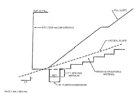
Where determined by the soils engineer, slopes that are steeper than five horizontal to one vertical (20% slope) and the height is greater than five, benching into sound bedrock or other competent material shall be provided. The bench under the toe of a fill on a slope steeper than five horizontal to one vertical (20% slope) shall be at least ten feet wide. The area beyond the toe of fill shall be sloped for sheet overflow or a paved drain shall be provided. When fill is to be placed over a cut, the bench under the toe of fill shall be at least ten feet wide. The cut shall be made before placing the fill and acceptance by the soils engineer or engineering geologist or both as a suitable foundation for fill. (See figure 110.2 Benching Details).
110.3 — Fill Material. Detrimental amounts of organic material shall not be permitted in fills. No rock or similar irreducible material with a maximum dimension greater than 12 inches shall be buried or placed in fills.
Exception: The Building Official may permit placement of larger rock when the soils engineer properly devises a method of placement, and continuously inspects its placement and approves the fill stability.
The following conditions shall also apply:
1. Prior to issuance of the grading permit, potential rock disposal areas shall be delineated on the grading plan.
2. Rock sizes greater than 12 inches in maximum dimension shall be ten feet or more below grade, measured vertically.
3. Rocks shall be placed to assure filling of all voids with well- graded soil.
110.4 — Compaction. All fill material shall be compacted to 90% of maximum density as determined by ASTM D.1557, modified proctor, in lifts not exceeding 12 inches in depth.
110.5 — Maximum slope. The slope of fill surfaces shall be no steeper than is safe for the intended use. Fill slopes steeper than two horizontal to one vertical (50%) shall be justified by soil reports or engineering data.
SECTION 111 — SETBACKS
111.1 — General. Cut and fill slopes shall be set back from the site boundaries in accordance with this section. Setback dimensions shall be measured perpendicular to the site boundary and shall be as shown in Figure 111, Drainage Dimensions, unless substantiating data is submitted justifying reduced setbacks.
111.2 — Top of cut slope. The setback at the top of a cut slope shall not be less than shown in Figure 111 or than is required to accommodate any required interceptor drains, whichever is greater.
111.3 — Toe of fill slope protection. Where required to protect adjacent properties at the toe of a slope from adverse effects of the grading, additional protection approved by the building official shall be included. Such protection may include but is not limited to:
1. Setback greater than those required by Figure 111.
2. Provision for retaining walls or similar construction.
3. Erosion protection of the fill slopes.
4. Provisions for the control of surface waters.
111.4 — Modification of slope location. The building official may approve alternate setbacks. The building official may require an investigation and recommendation by a qualified engineer or engineering geologist to demonstrate that the intent of this section has been satisfied.
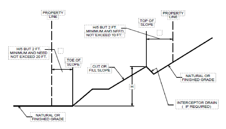
FIGURE 111 DRAINAGE DIMENSIONS
SECTION 112 — Drainage and Terracing
112.1 — General. Unless otherwise recommended by a registered design professional, drainage facilities and terracing shall be provided in accordance with the requirement of this section.
Exception. Drainage facilities and terracing need not be provided where the ground slope is not steeper than three horizontal to one vertical (33%).
112.2 — Terrace. Terraces at least six feet in width shall be established at not more than 30 foot (9144 mm) vertical intervals on all cut or fill slopes to control surface drainage and debris. Suitable access shall be provided to allow for cleaning and maintenance. Where two or more terraces are required, one terrace, located at approximately mid-height, shall be at least 12 feet (3658 mm) in width.
Swales or ditches shall be provided on terraces. They shall have a minimum gradient of 20 horizontal to one vertical (5%) and shall be paved with concrete not less than three inches (76 mm) in thickness or with other material suitable to the application. They shall have a minimum depth of 12 inches (305 mm) and a minimum of five feet.
A single run of swale or ditch shall not collect runoff from a tributary area exceeding 13,500 square feet (projected) without discharging into a down-drain.
112.3 — Subsurface drainage. Cut and fill slopes shall be provided with subsurface drainage as necessary for stability.
112.4 — Disposal. All drainage facilities shall be designed to carry waters to the nearest practicable drainage way approved by the Building Official or other appropriate jurisdiction as a safe place to deposit such waters. Erosion of ground in the area of discharge shall be prevented by installation of non-erosive down-drains or other devices.
Building pads shall have a drainage gradient of 2% toward approved drainage facilities, unless waived by the Building Official.
Exception: The gradient from the building pad may be % if all of the following conditions exist throughout the permit area:
1. No proposed fills are greater than ten feet in maximum depth.
2. No proposed finish cut or fill slope faces have a vertical height in excess of ten feet.
3. No existing slope faces steeper than one vertical to ten horizontal (10% slope) have a vertical height in excess of ten feet.
112.5 — Interceptor drains. Interceptor drains shall be installed along the top of cut slopes receiving drainage from a tributary width greater than 40 feet measured horizontally. They shall have a minimum depth of one foot and a minimum width of three feet. The slope shall be approved by the building official, but shall not be less than 50 horizontal to one vertical (2%). The drain shall be paved with concrete not less than three inches in thickness, or by other materials suitable to the application. Discharge from the drain shall be accomplished in a manner to prevent erosion and shall be approved by the building official.
112.6 — Drainage across property lines. Drainage across property lines shall not exceed that which existed prior to grading. Excess or concentrated drainage shall be contained on site or directed to an approved drainage facility. Erosion of the ground in the area of discharge shall be prevented by installation of non-erosive down- drains or other devices.
SECTION 113 — EROSION CONTROL
113.1 — Slopes. The faces of cut and fill slopes shall be prepared and maintained to control erosion. This control may consist of effective planting.
Exception. Erosion control measures need not be provided on cut slopes not subject to erosion due to the erosion-resistant character of the materials.
113.2 — Other devices. Where necessary, check dams, cribbing, riprap or other devices or methods shall be employed to control erosion and provide safety.
SECTION 114 — GRADING INSPECTION
114.1 — General. Grading operations for which a permit is required shall be subject to inspection by the building official.
Professional inspection shall be provided by the civil engineer, soils engineer and the engineering geologist retained to provide such services in accordance with Section 114.5 for engineered grading and as required by the building official for regular grading. A site investigation shall be performed to determine that such grading is going to conform to the boundaries of the designated ingress/egress easements and the boundaries of the easements shall be appropriately flagged to indicate easement locations and cut or fill locations.
114.2 — Civil engineer. The civil engineer shall provide professional inspection within such engineer's area of technical specialty, which shall consist of observation and review as to the establishment of line, grade and surface drainage of the development area. If revised plans are required during the course of the work they shall be prepared by the civil engineer.
114.3 — Soils engineer. The soils engineer shall provide professional inspection within such engineer's area of technical specialty, which shall include observation during grading and testing for required compaction. The soils engineer shall provide observation during the preparation of the natural ground, placement and compaction of the fill to verify that such work is being performed in accordance with of the approved plan and requirements of this chapter. Revised recommendations relating to conditions differing from the approved soils engineering and engineering geology reports shall be submitted to the permittee, the building official and the civil engineer.
114.4 — Engineering geologist. The engineering geologist shall provide professional inspection within such engineer's area of technical specialty, which shall include professional inspection of the bedrock excavation to determine if conditions encountered are in conformance with the approved report. Revised recommendations relating to conditions differing from the approved engineering geology report shall be submitted to the soils engineer.
114.5 — Permittee. The permittee shall be responsible for the work to be performed in accordance with the approved plans, specifications and with the provisions of this code. The permittee shall engage consultants, if required, to provide professional inspections on a timely basis. The permittee shall act as a coordinator between the consultants, the contractor and the Building Official. In case of changed conditions, the permittee shall be responsible for informing the Building Official of such change and shall provide revised plans for approval.
114.6 — Building official. The building official shall inspect the project at the various stages of work requiring approval to determine that adequate control is being exercised by the professional consultants.
114.7 — Notification of noncompliance. When fulfilling their respective duties under this chapter, if the civil engineer, the soils engineer or the engineering geologist finds discrepancies in work as not being in conformance with this ordinance or the approved grading plans, the discrepancies shall be reported immediately in writing to the permittee and to the building official.
114.8 — Transfer of responsibility. If the civil engineer, the soils engineer, or the engineering geologist of record is changed during grading, the work shall be stopped until a replacement engineer has agreed in writing to accept responsibility within their area of technical competence for approval upon completion of the work. It shall be the duty of the permittee to notify the building official in writing, of such change prior to the recommencement of such grading.
SECTION 115 — COMPLETION OF WORK
115.1 — Final reports. Upon completion of the rough grading work and at the completion of final grading work, the following are required:
1. As-built grading plans shall be prepared by the civil engineer retained to provide services in accordance with Section 106.4. Plans shall show original ground surface elevations, as-graded ground surface elevations, lot drainage patterns, and the locations and elevations of surface drainage facilities and of the outlets of subsurface drains. As-constructed locations, elevations and details of subsurface drains shall be shown as reported by the soils engineer.
Civil engineers shall state that to the best of their knowledge the work within their area of responsibility was done in accordance with the final approved grading plan.
Soils Engineer retained to provide services in accordance with Section 106.5 shall prepare a report. The report shall include locations and an elevation of field density tests, summaries of field and laboratory tests, and other substantiating data. Report shall include comments on any changes made during grading and their effect on the recommendations made in the approved soils engineering investigation report.
Soils engineers shall submit a statement that, to the best of their knowledge, the work within their area of responsibility is in accordance with the approved soils engineering report and applicable provisions of this chapter.
Engineering geologist retained to provide services in accordance with Section 106.4 shall provide a report. Report shall include a final description of the geology of the site and any new information disclosed during the grading and the
effect of same on recommendations incorporated in the approved grading plan. Engineering geologists shall submit a statement that, to the best of their knowledge, the work within their area of responsibility is in accordance with the approved engineering geologist report and applicable provisions of this chapter.
The grading contractor shall submit in a form prescribed by the building official a statement of conformance in according with the as-built plan and the specifications.
115.2 — Notification of completion. The permittee shall notify the building official when the grading operation is ready for final inspection. Final approval shall not be given until all work; including installation of all drainage facilities and their protective devices, and all erosion-control measures have been completed in accordance with the final approved grading plan.
(2) Findings and declaration. The Town of Dewey-Humboldt of Yavapai County, Arizona specifically and expressly finds and declares that the nature and uniqueness of the climate, terrain, and location does necessitate and demand specific amendments to the Dewey- Humboldt Grading Ordinance, which are stated in this ordinance.
(Ord. 21-159, passed 4-20-2021)