For development within five hundred feet (500') of a sensitive surface water body, the following additional standards shall apply:
A. Storm Water Management Plan: A storm water management plan shall be prepared by an Idaho licensed professional engineer or registered landscape architect with water quality training and experience. The plan shall include an evaluation of the impacts of the development as it relates to surface water quality of the adjacent water body, and provide recommendations for mitigation.
The development of the property shall not create any impacts that cannot be mitigated. The quality of surface water runoff shall be protected by utilization of best management practices (BMPs) identified in the DEQ manual entitled "Catalog Of Storm-Water Best Management Practices For Idaho Cities And Counties". Development shall comply with Idaho water quality standards.
B. Density: The following densities shall apply to divisions of land, unless a deviation is granted pursuant to the planned unit development process, up to but not to exceed the density allowed in the underlying zone. The density ratio standard shall not apply to individual building permit applications on existing parcels recorded prior to the adoption of this article nor portions of a lot beyond the five hundred foot (500') boundary. See example below:
Average Slope Within 500 Foot Boundary | Density See Example Below | Cluster Lots | Maximum Driveway Length |
15 – 25% | 0.5 acre | Encouraged | 250 feet |
25.01 – 35% | 1 acre | Encouraged | 100 feet |
Over 35% | 2.5 acres | Required | 100 feet |
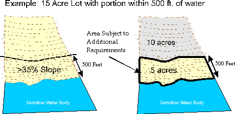
Example of a parcel split by the five hundred foot (500') overlay boundary:
Fifteen (15) acre lot zoned R-1;
Five (5) acres are within five hundred feet (500') of the water and that has a greater than thirty five percent (>35%) slope;
Exhibit 17.08.940A
Example: Fifteen Acre Lot With Portion
Within Five Hundred Feet Of Water
The zoning density (theoretical lot density) for the area within 500 foot boundary = 5 (area within boundary) divided by 2.5 (density factor for over 35% slope) = 2.0 units;
Development within this area must be clustered and a part of a planned unit development. Exhibit 17.08.940A of this section.
The density for the area outside of the 500 foot boundary = lot area divided by 34,500 (standard minimum lot size for the R-1 district) = 37. Note that the actual lot density would be affected by street design and other design factors.
C. Interagency Coordination: The city may request comments on the project from affected agencies, where appropriate. Where coordinated permits are necessary, approvals from permitting agencies may be required.
D. Waterfront Lots: For lots with frontage on sensitive water body, an undisturbed natural vegetation buffer shall be retained at the waterfront. A stairway, walkway, stairway landing, or a tram shall be allowed to encroach within the buffer. The buffer shall be a minimum of twenty five feet (25') from the high water mark of the water body. For purposes of this article, high water marks shall be considered to be the following elevations:
Coeur d'Alene Lake 2,125.0 (NGVD 1929 datum), (2128 WWP datum)
Fernan Lake 2,131.37 (Kootenai County site disturbance ordinance)
The high water marks for the Spokane River shall be determined by on site inspection of evidence of historical water levels. (Ord. 3160 §4, 2003: Ord. 3091 §10, 2003)