(A) Purpose and applicability. The structure of the MU district provides the city and future development groups with the regulations and guidelines needed to develop a comprehensive, resilient and pedestrian-oriented neighborhood. The subdivision regulations in division (C) provide the following:
(1) A network of connected streets and blocks that reflect an approved station area plan;
(2) General block sizes and configurations that support zoning and land use goals;
(3) Maximum block perimeters that foster attractive, safe and walkable environments, while enhancing circulation through the site;
(4) Guidance on meeting regional stormwater requirements as detailed in the Brooklyn Park Subarea Stormwater Master Plan.
(B) Regulating plan. The MU district is implemented through a regulating plan, to be submitted prior to or in conjunction with other required applications. Areas zoned MU must be divided into neighborhoods by the introduction of a primary thoroughfare network, and then into blocks by the completion of the streets and open spaces. Regulating plans must be recorded against all properties governed by the plan and must show the following:
(1) District boundaries;
(2) Existing infrastructure including streets, parks and open space;
(3) Thoroughfare network according to division (C) with thoroughfare assignments according to Table 21or Table 22;
(4) Civic area according to Table 19, with types and boundaries according to Table 23.
Table 19. Regulating Plan Requirements |
CIVIC SPACE |
Percentage of Area |
5 - 10% |
(C) Subdivision regulations. The provisions of this section will be used upon subdivision within the MU zoning district.
(1) The thoroughfare network must be laid out according to Table 20 and comply with the standards of division (D)(1)(a) below.
Table 20. Subdivision and Block Standards | |
BLOCK DIMENSIONS | DIMENSIONS |
Block length | 400 ft. max |
Block perimeter | 1,600 ft. max. |
Alley width | 16 ft. min. |
MID-BLOCK PEDESTRIAN PASSAGES | |
Pedestrian passage width | 12 ft. min., 24 ft. max. |
(a) Thoroughfare standards.
1. All thoroughfares must connect to other thoroughfares, forming a network.
a. New thoroughfares must connect wherever possible to thoroughfares on adjacent sites. Cul-de-sacs may only be permitted by approval of the City Manager to accommodate specific site conditions.
b. New thoroughfares must implement any approved Small Area Plan Street Network and use street section options from Table 21.
c. A section may be chosen according to right-of-way width and functional classification. New thoroughfare sections may be created using the standards in Table 22.
(b) Block dimensions.
1. Block length and perimeter may be adjusted up to 20% with approval from the City Manager due to topography, existing development conditions, or if the block is at the perimeter of the regulating plan. Block lengths up to 800 feet may be approved if a mid- block pedestrian passage is provided.
(c) Mid-block pedestrian passages.
1. In areas with adequate vehicular capacity, pedestrian-only connections may be used mid-block and will count as a new edge in block perimeter calculations.
(d) Parking lot layout.
1. In addition to the parking regulations of § 152.605(A), parking lots in MU must be laid out as blocks per Table 20, with utilities located in the drive aisles. Drive aisles must have adequate width to redevelop with rights-of-way required by one or more of the thoroughfare sections in Table 21.
Table 21. Thoroughfare Sections
| ||
STREET 98 - 72
|
ILLUSTRATION
| |
Table 21. Thoroughfare Sections
| ||
STREET 98 - 72
|
ILLUSTRATION
| |
Functional class | Arterial | 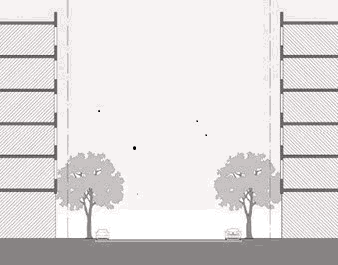 |
Right-of-way | 98 ft. min. | |
Design, target speed | 30 - 35 mph | |
TRAVELED WAY
| ||
(TL) Vehicle lanes | 3 | |
Vehicle lane width | 10 ft.1 | |
Movement | Two-way | |
(PK) Parking lanes | 2 | |
Parking lane width | 8 ft. | |
(BL) Bicycle facility | Buffered lane | 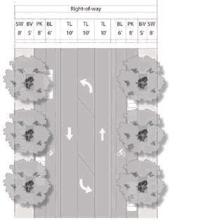 |
Bicycle facility width | 6 ft. + 3 ft. buffer | |
(MD) Median | n/a | |
Turning lanes | At arterial intersections only | |
STREETSCAPE
| ||
(SW) Sidewalk width | 8 ft. min. | |
(BV) Boulevard width | 5 ft. min., 7 ft. max. | |
Boulevard type | Long tree well, 5 ft. x 14 ft. min. | |
Tree spacing | 30 ft. on center | |
1 Subject to MNDOT approval. | ||
STREET ST 70 - 46
| ||
Functional class | Primary, local, local street | 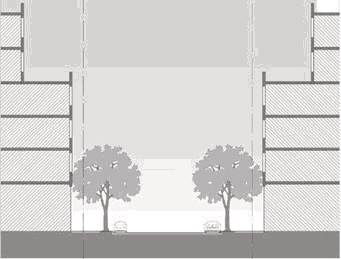 |
Right-of-way | 74 ft. min. primary local 70 ft. min. local street | |
Design, target speed | 25 mph | |
TRAVELED WAY
| ||
(TL) Vehicle lanes | 2 | |
Vehicle lane width | 10 ft.2 | |
Movement | Two-way | |
(PK) Parking lanes | 2 | |
Parking lane width | 8 ft. | |
(BL) Bicycle facility | Lane (local street), buffered lane (primary local) | 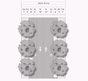 |
Bicycle facility width | 6 ft. + 2 ft. buffer (primary local) | |
(MD) Median | n/a | |
Turning lanes | n/a | |
STREETSCAPE
| ||
(SW) Sidewalk width | 7 ft. min. | |
(BV) Boulevard width | 5 ft. min., 7 ft. max. | |
Boulevard type | Long tree well, 6 ft. x 14 ft. min. | |
Tree spacing | 30 ft. on center | |
2 Subject to MNDOT approval. | ||
Functional class | Primary local, local street |  |
Right-of-way | 60 ft. min. primary local 58 ft. min. local street | |
Design, target speed | 25 mph | |
TRAVELED WAY
| ||
(TL) Vehicle lanes | 2 | |
Vehicle lane width | 10 ft. primary local3 | |
Movement | Two-way | |
(PK) Parking lanes | 2 | |
Parking lane width | 8 ft. | |
(BL) Bicycle facility | sharrow optional |  |
Bicycle facility width | n/a | |
(MD) Median | n/a | |
Turning lanes | n/a | |
STREETSCAPE
| ||
(SW) Sidewalk width | 8 ft. min. | |
(BV) Boulevard width | 6 ft. min, 7 ft. max. | |
Boulevard type | Long tree well, 6 ft. x 14 ft. min. | |
Tree spacing | 30 - 35 ft. on center | |
3 Subject to MNDOT approval. | ||
STREET 49-27
|
ILLUSTRATION
| |
Functional class | Local street | 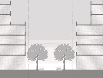 |
Right-of-way | 49 ft. min. | |
Design, target speed | 20 mph | |
TRAVELED WAY
| ||
(TL) Vehicle lanes | 2 | |
Vehicle lane width | 10 ft.4 | |
Movement | Two-way | |
(PK) Parking lanes | 1 | |
Parking lane width | 8 ft. | |
(BL) Bicycle facility | sharrow optional | 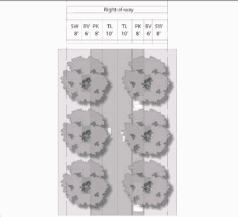 |
Bicycle facility width | n/a | |
(MD) Median | n/a | |
Turning lanes | n/a | |
STREETSCAPE
| ||
(SW) Sidewalk width | 6 ft. min. | |
(BV) Boulevard width | 5 ft. min, 7 ft. max. | |
Boulevard type | Long tree well, 5 ft. x 14 ft. min. | |
Tree spacing | 30 ft. on center | |
4 Subject to MNDOT approval. | ||
(2) Civic standards.
(a) The minimum and maximum percentage of land to be dedicated and deeded as civic space is shown in Table 23. Civic spaces must be designed according to Table 23.
Table 23. Civic Space Types
| ||
SQUARE
| ||
Table 23. Civic Space Types
| ||
SQUARE
| ||
Size in acres | 0.25 - 2.5 |  |
Proportion (a:b) | 1:5 max. | |
Edge condition | Thoroughfares on a minimum of two non-adjacent sides | |
Surface | 50% maximum paved; pervious paving allowed | |
Landscape | 1 tree with mature canopy over 25 ft. per 800 sq. ft. of area min. | |
PLAZA
| ||
Size in square feet | 5,000 - 20,000 | 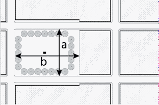 |
Proportion (a:b) | 1:5 max. | |
Edge condition | Thoroughfares on a minimum of two sides | |
Surface | 50% minimum paved; pervious paving allowed; bituminous pavement prohibited | |
Landscape | 1 tree with mature canopy over 25 ft. per 1,000 sq. ft. of area min. | |
POCKET PARK
| ||
Size in square feet | 1,000 - 5,000 | 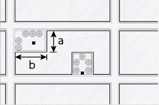 |
Proportion (a:b) | 1:4 max. | |
Edge condition | 1 side minimum along a thoroughfare or pedestrian passage | |
Surface | May be paved or landscaped | |
Landscape | 1 tree with mature canopy over 20 ft. per 600 sq. ft. of area min. | |
PEDESTRIAN PASSAGE
| ||
Width | 12 ft. min., 24 ft. max. | 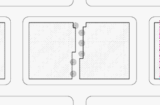 |
Edge condition | Active frontages required in high intensity blocks | |
Walkway width | 6 ft. min. | |
Landscape | 3 ft. minimum landscape edge in medium and low intensity blocks | |
(3) Lot standards.
(a) Lots must have minimum and maximum widths according to Table 24.
(b) Each lot must have a primary frontage along a vehicular thoroughfare, except up to 20% of the parcels in a regulating plan may front a civic space or pedestrian passage.
(c) Where lots have multiple frontages, one frontage line must be designated as primary and any other frontage lines must be designated as secondary.
Table 24. Lot Width
| |
20 ft. min. | 400 ft. max. |
(D) Standards. All parcels in MU must meet the standards of Table 25 according to the requirements of § 152.601.
Table 25. MU Building and Site Standards |
Table 25. MU Building and Site Standards | |||
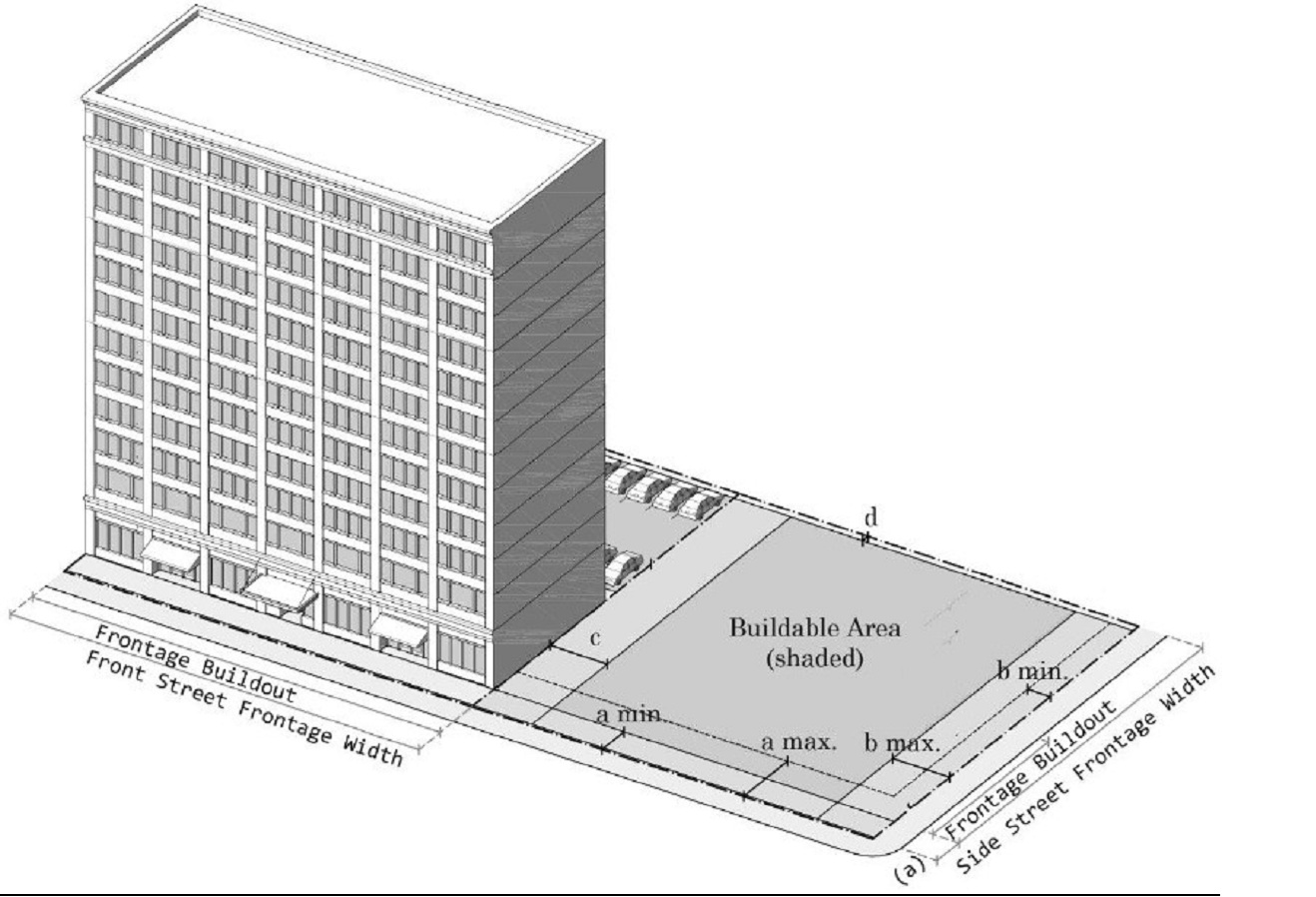 | |||
BUILDING SETBACKS | PARKING AND STORAGE SETBACKS | ||
a. Front street | 1 ft. min. - 12 ft. max. | Front street | 30 ft. min. |
b. Side street | 2 ft. min. - 12 ft. max. | Side street | 12 ft. min. |
c. Side property line | 0 ft. or 6 ft. min. | Side property line | 0 ft. min. |
d. Rear property line | 3 ft. min. | Rear property line | 3 ft. min. |
MINIMUM FRONTAGE BUILDOUT | LOT COVERAGE AND FLOOR AREA RATIO | ||
Front street | 80% min. | Lot coverage by building | 80% max |
Side street | 50 ft. min. from front street | Minimum Floor Area Ratio | .75 |
MINIMUM GLAZING | FACADE TYPES | ||
Front street | 30% min. | Shopfront | Common entry |
Side street | 30% min. | Forecourt | Stoop |
Upper floors | 10% min. | Porch | |
BUILDING HEIGHT
| |||
8 stories max. | Parking structure height | 1 story less than building | |
USES
| |||
RESIDENTIAL | COMMERCIAL | ||
P | Multiple dwelling | P | Sales and service |
P | Townhouse | P | Restaurants and brewpubs |
P | Care facility and convalescent home | P | Office |
INSTITUTIONAL | P | Medical clinics | |
P | Religious assembly | P | Child care |
P | Schools | P | Adult day care |
P | Libraries | P | Parking |
P | Museums | P | Lodging |
C | Breweries and micro-distilleries | ||
OTHER | C | Taprooms and cocktail rooms | |
C | Wireless communication facilities | C | Entertainment |
C | Drive-through facilities | ||
NP | Fuel stations | ||
NP | Auto oriented repair services, Carwashes, Heavy equipment, machinery and farm vehicle sales, contractors yards, bulk firewood sales, and gravel and rock sales, Indoor sales of automobiles, trucks and recreational vehicles and the like, Self-storage facilities, adult entertainment and retail, impound lots, vehicle sales | ||
(Ord. 2023-1294, passed 11-13-23)