For the purpose of this subchapter, the following definitions shall apply unless the context clearly indicates or requires a different meaning.
ABUTTING. Bordering.
ACCESSORY BUILDING AND USE. A building or use subordinate to another structure or use located on the same lot and which does not change or alter the character of the premises and which is not used for human occupancy; such as public utility installation, electric distribution and secondary power lines, gas, water and sewer lines, their supports and poles, guy wires, small transformers, wire or cable, incidental equipment and public telephone booths.
AGRICULTURE. The art of science of cultivating the ground, and raising and harvesting crops, also often including feeding, breeding and management of livestock; tillage, husbandry; farming; in a broader sense, the science and art of the production of plants and animals useful to humans, including to a variable extent the preparation of these products for humans’ use and their disposal by marketing or otherwise. In this broad use it includes farming, horticulture, forestry, dairying and sugar making.
AIRPORT. A use devoted to the take-off, landing and storing of aircraft.
ALLEY. A permanent public service way providing a secondary means of access to abutting lands.
ALLEY LINE. A lot line bordering on an alley.
ALTERATION. Any addition, removal, extension, or change in the construction or occupancy of any existing building or structure.
APARTMENT. A building or portion thereof designed for or occupied by more than 2 families; a multi-family dwelling.
AUTOMOBILE OR TRAILER SALES AREA. An open area, other than a street, used for the display, sale or rental of new or used automobiles or trailers, and where no repair work is done except minor incidental repair work is done except minor incidental repair of automobiles or trailers to be displayed, sold or rented on the premises.
BASEMENT. A story, wholly or partly underground, which unless subdivided into rooms and used for tenant purposes, shall purposes of height measurement.
BLOCK. A unit or property bounded by streets, or by streets and railroad rights-of-way, waterways or other barriers.
BLOCK FRONTAGE. Property having frontage on 1 side of a street and lying between the 2 nearest intersecting streets, or nearest intersecting street and railroad right-of-way, waterway or other barrier.
BOARD. The Board of Zoning Appeals.
BOARDING HOUSE or LODGING HOUSE. A building where meals are regularly served for compensation for 3 or more persons, but not exceeding 12 persons, not open to transients, in contradistinction to hotels and restaurants open to transients.
BUILDING. A structure having a roof supported by columns or walls, for shelter, support, enclosure or protection of persons, animals, chattels or other property. When separated by party walls, without opening through walls, each portion of a BUILDING shall be considered a separate structure.
BUILDING AREA. The maximum horizontal projected area of the principal and accessory building, excluding open steps or terraces, unenclosed porches not exceeding 1 story in height or architectural appurtenances projecting not more than 2 feet.
BUILDING, DETACHED. A building having no structural connection with another building.
BUILDING, FRONT LINE OF. The line of the face of the building nearest the front lot line.
BUILDING, HEIGHT OF. The vertical distance measured from the lot ground level to the highest point of the roof for a flat roof; to the deck line of a mansard roof; and to the mean height between eaves and ridges for gable, hip and gambrel roofs.
BUILDING LINE or BUILDING SETBACK LINE. The line nearest the front of and across a lot establishing the minimum open space to be provided between the front line of a building or structure and the front lot line.
BUILDING, PRINCIPAL. A building in which is conducted the main or principal use of the lot on which the building is situated. Where a substantial part of an accessory building is attached to the PRINCIPAL BUILDING in a substantial manner, as by a roof, an accessory building shall be counted as a part of the PRINCIPAL BUILDING.
BUSINESS. The engaging in the purchase, sale, barter or exchange of goods, wares, merchandise or services, the maintenance or operation of offices or recreational and amusement enterprises for profit.
CAMP, PUBLIC. Any area or tract of land used or designed to accommodate 2 or more camping parties, including cabins, tents or other camping outfits.
CEMETERY. Land used for the burial of the dead and dedicated for cemetery purposes, including columbariums, crematories, mausoleums and mortuaries when operated in conjunction with and within the boundary of a CEMETERY.
CLUB. Buildings and facilities owned or operated by a person for a social, educational or recreational purpose, but not primarily for profit or to render a service which is customarily carried on as a business.
COMMERCIAL FARM ENTERPRISE. An operation or use inherent to or closely associated with a farm or agriculture, such as the buying, selling or distribution of livestock, farm or agricultural products; or products essential to farm operation; but not including industrial grain elevators, industrial mills, abattoirs, commercial hatcheries and poultry processing plants, the manufacture of commercial fertilizers and similar enterprises which are of an industrial nature.
COMMISSION. The Plan Commission.
COMPREHENSIVE MASTER PLAN. The complete plan or any of its parts for the development of the city, prepared by the Plan Commission and adopted in accordance with Chapter 174, Acts of 1947, General Assembly of Indiana, as is now or may hereafter be in effect.
DECIBEL. A unit of measurement of the intensity of loudness of sound. Sound level meters are used to measure intensities and are calibrated in DECIBELS.
DEVELOPMENT PLAN. A drawing, including a legal or site description, of the real estate involved, which shows the location and size of the following, both existing and proposed: all buildings, structures and yards; location and dimensions of building lines and easements; widths and lengths of all entrances and exits to and from real estate; location of all adjacent or adjoining streets, service facilities and other improvements such as planting areas.
DEVELOPMENT PLAN, RESIDENTIAL. A plan proposed to use a tract of land for residential development in accordance with the requirements of this subchapter, even though the use of the land, the location of the buildings to be erected in the area, and the yards and open spaces provided in the plan do not conform in certain respects to the regulations for the district in which the residential development is proposed to be located.
DISTRICT. A section of the territory within the jurisdiction of the Plan Commission for which uniform regulations governing the use, height, area, size and intensity of the use of buildings and land, and open spaces about buildings, are herein established.
DWELLING. A building or portion thereof, used primarily as a place of abode for 1 or more human beings, but not including hotels, motels, lodging or boarding houses or tourist homes.
DWELLING UNIT. A dwelling or portion of a dwelling used for 1 family for cooking, living and sleeping purposes.
EDUCATIONAL INSTITUTION. Public or parochial preprimary, primary, grade, junior high, high preparatory school or academy; junior college, college or university, if public or founded or conducted by under the sponsorship of a religious or charitable organization.
FAMILY. One or more persons occupying a building and living as a single housekeeping unit, as distinguished from a group occupying a hotel, club, nurses home, fraternity or sorority house.
FARM. A tract of land comprising an area which is devoted to agricultural operations, such as forestry, the growing of crops, pasturage, the production of livestock and poultry, the growing of trees, shrubs and plants and other recognized agricultural pursuits and including accessory buildings essential to the operation of the farm. Accessory buildings may include barns; equipment and animal sheds; farm residences for the owner, operator or farm assistants; roadside sales structure for the sale of products of the farm; and signs displaying subject matter directly related to the name or the products of the particular farm; but not including industrial or commercial operations or structures.
FILLING STATION. Any building, structure, premises, enclosure or other place used for the dispensing, sale or offering for sale at retail of fuels or oils for motor vehicles. When the dispensing, sale or offering for sale is incidental to the conduct of a public garage, the premises shall be classified as a public garage.
FLASH POINT. The lowest temperature at which a combustible liquid under prescribed conditions will give off a flammable vapor which will burn momentarily using the closed cup method.
FLOOR AREA, GROUND. The square foot area of a residential building within its largest outside dimensions computed on a horizontal plane at the ground floor level exclusive of open porches, breezeways, terraces, garages and exterior stairways.
FLOOR AREA, NET. The total area, computed on a horizontal plane, used for a particular business category; exclusive of entrances, hallways, stairs and other accessory areas used for ingress or egress.
FREE BURNING. A rate of combustion described by a material which burns actively, and easily supports combustion.
FRONTAGE. All the property on 1 side of a street between 2 intersecting streets (crossing or terminating) measured along the line of the street, or if the street is dead ended, then all of the property abutting on 1 side between an intersecting street and the dead end of the street.
GARAGE, PRIVATE. An accessory building with capacity for not more than 3 motor vehicles per family, not more than 1 of which may be a commercial vehicle of not more than 3 tons capacity. A garage designed to house 1 or 2 motor vehicles for each family housed in a multi-family dwelling shall be classed as a PRIVATE GARAGE.
GARAGE, PUBLIC. Any building, except those defined herein as a private garage, used for the storage, or care of motor vehicles, or where vehicles are equipped for operation, repaired or kept for remuneration, hire or sale.
GRADE or LOT GROUND LEVEL. For buildings having walls adjoining 1 street only, the elevation of the sidewalk at the center of the wall adjoining the street. For buildings having walls adjoining more than 1 street, the average of the elevation of the sidewalk at the center of all walls adjoining streets. For buildings having no wall adjoining the street, the average level of the ground adjacent to the exterior walls of the building. Any wall approximately parallel to and not more than 5 feet from a street line is to be considered as adjoining the street.
GROUP HOUSE. A group of dwellings constructed in a row, with the dwelling units separated by vertical party walls without openings. A multi-family dwelling.
HARDSHIP. A perceived difficulty with regard to one's ability to improve land stemming from the application of the development standards of this subchapter, which may or may not be subject to relief by means of variance. In and of themselves, self-imposed situations and claims based on a perceived reduction of our restriction on economic gain shall not be considered hardship. Self-imposed situations include: The purchase of land with actual or constructive knowledge that, for reasons other than physical characteristics of the property, the development standards herein will inhibit the desired improvement initiated in violation of the standard of this subchapter; any results of land division requiring variance from the development standards of this subchapter in order to render that site buildable.
HOME OCCUPATION. Any use conducted entirely within a dwelling and participated in solely by members of the family, which use is clearly incidental and secondary to the use of the dwelling for dwelling purposes and does not change the character thereof and in connection with which there is no commodity sold on the premises except that which is produced thereon, provided that no sign other than a nameplate is attached to the building.
HOSPITAL. An institution licensed by the State Department of Health and providing health services primarily for in-patient medical or surgical care of the sick or injured and including related facilities such as laboratories, out-patient departments, training facilities, central service facilities and staff offices which are an integral part of the facility, provided the institution is operated by, or treatment is given under direct supervision of a licensed physician. Types of HOSPITALS include general, mental, chronic disease and allied special hospitals such as cardiac, contagious disease, maternity, orthopedic, cancer and the like.
HOTEL. A building in which lodging is provided and offered to the public for compensation and which is open to transient guests, in contradistinction to a boarding or loading house.
IMPROVEMENT LOCATION PERMIT. A permit signed by the Planning Administrator stating that a proposed improvement complies with the provisions of this chapter and other ordinances as may be applicable.
INDUSTRIAL PARK. A single structure or group of structures for industrial operations forming a comprehensive arrangement of buildings, grounds and access ways planned in accordance with harmonious principles of architectural and landscape architectural design, and industrial management.
INTENSE BURNING. A rate of combustion described by a material that burns with a high degree of activity and is consumed rapidly.
JUNK YARD. Any place at which personal property is or may be salvaged for reuse, resale or reduction or similar disposition and is owned, possessed, collected, accumulated, dismantled or assorted, including but not limited to, used or salvaged base metal or metals, their compounds or combinations, used or salvaged rope, bags, papers, rags, glass, rubber, lumber, millwork, brick and similar property except animal matter; and used motor vehicles, machinery or equipment which is used, owned or possessed for the purpose of wrecking or salvaging parts therefrom.
JURISDICTION OF THE COMMISSION. The territory for planning and zoning within the jurisdiction of the City Plan Commission.
KENNEL. Any lot on which 4 or more dogs, or small animals, at least 4 months of age are kept.
LOADING AND UNLOADING BERTHS. The off-street area required for the receipt or distribution by vehicles of material or merchandise, which in this chapter is held to be a 12 by 45-foot loading space with a 14-foot height clearance; 50% of the lot width prescribed for the district in which the lot is located. It may be a single parcel separately described in a deed or plat which is recorded in the Office of the Recorder of the County, or it may include parts of, or a combination of parcels when adjacent to one another and used as 1. In determining lot area and boundary lines no part thereof within the limits of a street or place shall be included.
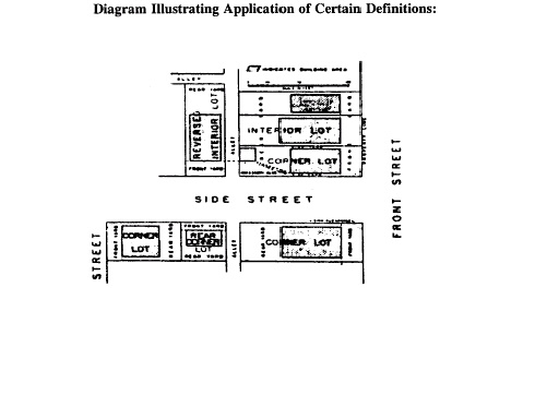
LOT, CORNER. A lot at the junction of and abutting 2 or more intersecting streets.
LOT COVERAGE. The percentage of the lot area covered by the building area.
LOT, DEPTH OF. The mean horizontal distance between the front lot line and the rear lot line of a lot, measured in the general direction of the side lot line.
LOT, INTERIOR. A lot other than a corner lot or through lot.
LOT LINE, FRONT. In the case of an interior lot, a line separating the lot from the street or place; and in the case of a corner lot a line separating the narrowest frontage of the lot from the street, except in cases where deed restrictions in effect specify another street right-of-way line as the front lot line.
LOT LINE, REAR. A lot line which is opposite and most distant from the front lot line and, in the case of an irregular or triangular-shaped lot, a line 10 feet in length within the lot, parallel to and at the maximum distance from the lot line.
LOT LINE, SIDE. Any boundary line not a front lot line or a rear lot line.
LOT OF RECORD. A lot which is part of a subdivision, the map of which has been recorded in the office of the County Recorder of Clay County, Indiana, or a parcel of land, the deed to which has been recorded in the office of the County Recorder Clay County, Indiana, on or before the date of passage of this chapter.
LOT, REVERSED INTERIOR. An interior lot, the front lot line of which is formed by a street, which street also forms the side lot line of an abutting corner lot. The corner lot is considered abutting even though separated from the interior lot line by an alley.
LOT, THROUGH. A lot having frontage of 2 parallel or approximately parallel streets.
LOT WIDTH. The dimension of a lot, measured between side lot lines on the building line.
MOBILE HOME. Any vehicle either self-propelled or propelled by means of being attached to a motor vehicle, which may be used as a place of abode or sleeping place by 1 or more persons, and which has no foundation other than the wheels required for its movement from 1 place to another.
MOBILE HOME PARK. An area of land on which 2 or more mobile homes are harbored for the purpose of being occupied either free of charge or in consideration of the payment of rental for the mobile home or the site on which it rests, and within which area a mobile home may be supported either by its wheels or by a foundation of any sort.
MODERATE BURNING. A rate of combustion described by a material which supports combustion and is consumed slowly as it burns.
MOTEL. Any building or detached building used as dwelling units containing bedroom, bathroom and closet space, and each unit having convenient access to a parking space for the use of the unit's occupants. The units, with the exception of the apartment of the manager or caretaker, are devoted to the use of automobile transients.
NURSING HOME. A facility licensed by the State Board of Health, which provides nursing services on a continuing basis; admits the majority of the occupants on the advice of physicians as ill or infirm persons requiring nursing services; provides for licensed physicians services or supervision; and maintains medical recorded. These facilities may also provide other and similar medical or health services, provided that no occupant requires physical restraint within the facility. Examples of nursing home facilities that provide health services may include, if they comply with all the above criteria, nursing homes, convalescent homes, maternity homes, rest homes, homes for the aged and the like.
NURSING HOME CONVERSIONS. A dwelling which is converted for the use of a nursing home and licensed by the State Board of Health.
OCTAVE BAND. A narrow range of sound frequencies which classify sounds according to pitch. In the octave band analyzer the audible sound spectrum is divided into 8 OCTAVE BANDS.
OCTAVE BAND ANALYZER. An electrical device used with the sound level meter that sorts a complex noise or sound into the various octave bands.
PARKING AREA, PUBLIC. An open area, other than a street or alley designed for use or used for the temporary parking of more than 4 motor vehicles when available for public use, whether free or for compensation, or as an accommodation for clients or customers.
PARKING SPACE. A space other than on a street or alley designed for use or used for the temporary parking of a motor vehicle, and being not less than 9 feet wide and 20 feet long exclusive of passageways.
PARTICULATE MATTER. Finely divided liquid or solid material which is discharged and carried along in the air. This shall not include water droplets, commonly called steam.
PLACE. An open, unoccupied, officially designated space other than a street or alley, permanently reserved for use as the principal means of access to abutting property.
PLANNING ADMINISTRATOR. The official designated by the Common Council and authorized to enforce this chapter.
PLAT. A map or chart indicating the subdivision or resubdivision of land, intended to be filed for record.
PREMISES. A lot or plat including buildings thereon, if any.
PRIVATE SCHOOL. Private, primary, grade, high or preparatory school or academy.
PROFESSIONAL OFFICE. Office of a member of a recognized profession as defined by the United States Bureau of the Census.
PROFESSIONAL OFFICE CENTER. An architectural and functional grouping of professional offices and appropriate associated and accessory uses which is the central feature of a site plan composed of building area, parking area, landscaped reservation and plantation and other land features appropriate for its use as a professional office enterprise, designed to serve residential neighborhoods, and shall conform to the standards and requirements of this chapter.
PUBLIC UTILITY INSTALLATION. The erection, construction, alteration or maintenance by public utilities, municipal departments, commissions or common carriers of underground, surface or overhead gas, oil, electrical, steam, pipes, conduits, cables, fire alarm boxes, police call boxes, traffic signals, hydrants, towers and other similar equipment and accessories in connection therewith, reasonably necessary for the furnishing of adequate service by public utility or municipal departments, commissions or common carriers, for the public health, safety or general welfare.
RINGELMANN NUMBER. The number of the area of the Ringelmann Chart that most nearly matches the light-obscuring capacity of smoke. The Ringelmann Chart is described in the U.S. Bureau of Mines Information Circular 6888, on which are illustrated graduated shades of gray for use in estimating smoke density. Smoke below the density of Ringelmann No. 1 shall be considered no smoke, or Ringelmann 0.
SHOPPING CENTER. An architectural and functional grouping of retail stores, generally oriented around supermarket or department store, and appropriate associated and accessory uses, which is the central feature of a site plan or development plan composed of building areas, parking areas, access streets and circulatory ways for vehicles and pedestrians, landscape reservations and plantations and other land features appropriate for its operation as a business enterprise, designed to serve residential neighborhoods or communities and which conforms to the requirements of this ordinance.
SLOW BURNING or INCOMBUSTIBLE. Materials which do not in themselves constitute an active fuel for the spread of combustion. A material which will not ignite, nor actively support combustion during an exposure for 5 minutes to a temperature of 1200°F.
SMOKE. A suspension of fine particles, excluding water droplets, in a gaseous plume, which obscure more or less the transmission of light.
SMOKE UNIT. The number obtained when the smoke density in Ringelmann Number is multiplied by the time of emission in minutes. For the purpose of this calculation, a Ringelmann density reading shall be made at lease once a minute during the period of observation; each reading is then multiplied by the time in minutes during which it is observed. The various products are then added together to give the total number of SMOKE UNITS observed during the entire observation period.
SPECIAL SCHOOL. Any school which has as its primary purpose the instruction, care and rehabilitation of atypical or exceptional children or adults so that the usual statutory educational requirements expressly or implicitly do not apply.
STORY. That portion of a building, included between the surface of any floor and the surface of the floor next above it. If there is no floor above it, then the space between the floor and the ceiling next above it shall be the STORY.
STORY, HALF. That portion of a building under a sloping, gable, hip or gambrel roof, the wall plates on at least 2 opposite exterior walls of which are not more than 3 feet above the floor level of a HALF STORY.
STREET. A right-of-way or thoroughfare, other than an alley or place, dedicated or otherwise legally established to the public use, usually affording the principal means of access to abutting property.
STRUCTURE. Anything constructed or erected which requires location on the ground or attachment to something having a location on the ground.
STRUCTURAL ALTERATION. Any change in the supporting members of a building, such as bearing walls or partitions, columns, beams or girders, or any substantial change in the exterior walls or the roof.
SWIMMING POOL, PRIVATE. A swimming pool used only by the owner of the pool and friends as an accessory use at a private residence.
TOURIST HOME. A building in which 1 but not more than 5 rooms are used to provide or offer overnight accommodations to transient guests for compensation.
TRADE SCHOOL or BUSINESS SCHOOL. Secretarial or business school or college when not publicly owned or owned or conducted by or under the sponsorship of a religious, charitable or nonprofit organization; or a school conducted as a commercial enterprise for teaching instrumental music, dancing, barbering or hair dressing, drafting or for teaching industrial or technical arts.
USE. The employment or occupation of a building, structure or land for a person's service, benefit or enjoyment.
USE, NONCONFORMING. An existing use of land or building which fails to comply with the requirements set forth in this chapter applicable to the district in which the use is located.
VARIANCE. A modification of the specific requirements of this chapter granted by the Board in accordance with the terms of this chapter for the purpose of assuring that no property, because of special circumstances applicable to it, shall be deprived of privileges commonly enjoyed by other properties in the same vicinity and district.
VIBRATION. Oscillatory motion transmitted through the ground.
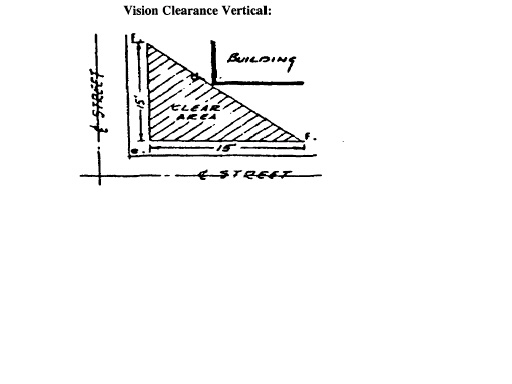
VISION CLEARANCE ON CORNER LOTS. A triangular space at the street corner of a corner lot, free from any kind of obstruction to vision between the heights of 3 and 12 feet above the established street grade. The street grade is measured at the intersection of the center lines of the intersecting street pavements, and the triangular space is determined by a diagonal line connecting 2 points measured 15 feet along each of the street property lines equidistant from the intersection of the property lines or the property lines extended, at the corner of the lot.
(1) Three feet above established street grade.
(2) Twelve feet established street grade.
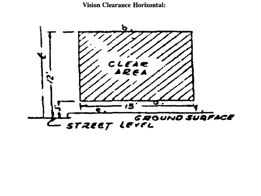
(3) Point of established street grade.
(4) Diagonal line forming rear line of triangle.
(5) Intersection of right-of-way or property lines.
(6) Fifteen feet from intersection of right-of-way or property lines.
YARD. A space on the same lot with a principal building, open, unoccupied and unobstructed by structures, except as otherwise provided in this chapter.
YARD, FRONT. A yard extending across the full width of the lot unoccupied other than by steps, walks, terraces, driveways, lamp posts and similar structures, the depth of which is the least distance between the front lot line and the building line.
YARD, REAR. A yard extending across the full width of the lot between the rear of the principal building the rear lot line unoccupied other than by accessory buildings which do not occupy more than 30% of the required space, and steps, walks, terraces, driveways, lamp posts and similar structures, the depth of which is the least distance between the rear lot line and the rear of the principal building.
YARD, SIDE. A yard between the principal building and the side lot line, extending from the front year or from the front lot line where no front yard is required, to the rear yard. The width of the required SIDE YARD is measured horizontally at 90 degrees with the side lot line, from the nearest part of the principal building, except in cases where irregular or pie-shaped lots are located, then the width of the required SIDE YARD shall be an average of the width of the area between the side lot line and the principal building measured horizontally at 90 degrees with the side lot line.
ZONE MAP. A map entitled “Brazil, Indiana, Zone Map,” dated January, 1964.
(1982 Code, § 156.02) (Ord. 12-1964, passed 8-11-1964; Am. Ord. 40-2006, passed 12-12-2006)