(A) Pre-application. From the standpoint of economy of time and money, it is recommended that the subdivider consult early and informally with the Director for advice and assistance. This will enable the subdivider to become familiar with these and other regulations as they affect the area and will prevent unnecessary and costly revisions.
(B) Concert plan. The concept plan is required as part of any application for primary plat approval for major subdivisions. The applicant shall submit the concept plan to a public meeting of the APC prior to the primary plat hearing for the purpose of discussion and recommendations. The concept plan shall be drawn at a scale of 50 feet to 1 inch, except that when the drawing at that scale requires more than one sheet, the plan may be drawn at a scale of 100 feet to 1 inch. Sheets shall not exceed 24 inches by 36 inches in size. The concept plan shall consist of a site analysis map and a site development map.
(1) Site analysis map. A location map which may be prepared by indicating the required information by notation on available maps of an appropriate scale. The purpose of the site analysis map is to indicate consideration and respect for the unique features of a site. A site analysis map shall include the following:
(a) Location of the proposed subdivision, including adjacent parcels of land;
(b) Existing schools, parks, fire, police and emergency medical (EMS) facilities that will serve the subdivision;
(c) Public thoroughfares that will serve the subdivision;
(d) Water and sewer services to serve the subdivision, if applicable;
(e) Primary conservation areas;
(f) Secondary conservation areas;
(g) Location of streets and thoroughfares including those in contiguous subdivisions or undeveloped property;
(h) Other unique features or characteristics of the site such as views (to and from the site), impacts (by the subdivision or by surrounding elements) and geographical features; and
(i) Indication of the resulting prime location for houses after site analysis.
(2) Site development map. The site development map shall indicate the proposed layout of the subdivision, including streets, lots, houses and common areas. In coordination with a primary plat application, the primary plat may act as the site development map.
(3) Notice of public meeting. A placard displaying the public meeting date and relevant information for the concept plan will be posted on the subject site in a prominent, visible location as the notice of public hearing. The non-refundable cost of the placard shall be borne by the applicant at the time of filing as noted in the fee schedule.
(4) Public meeting. The concept plan shall go before the APC for presentation to and suggestions by the APC. While no official action shall be taken, the APC shall mandate impact assessments to be performed prior to application for primary plat.
(5) Impact assessment. As a result of concept plan review, the APC may require that impact assessments be clone for discussion at the time of the primary plat hearing. Impact assessment shall be performed by a qualified professional with training, experience, and expertise in the field relevant to the specific section of the study in which work shall be performed. The APC shall mandate such studies at the expense of the applicant and of the professional of choice of the APC. The assessment may include any of the following: traffic and transportation; tax base; water and sewer service; fire, police and emergency services; schools; parks. Any additional expense necessary to ensure adequate information, reports or plans shall be met by the applicant.
(C) Primary plat.
(1) Application.
(a) A subdivider desiring approval of a primary plat of a subdivision of any land lying within Boone County shall submit to the Director:
1. A written application for approval;
2. Ten copies each of the concept plan and primary plat;
3. Draft covenants and restrictions of the subdivision;
4. All impact assessments mandated by the APC;
5. A clear transparency at a scale of 1 inch = 400 feet to overlay on aerial maps; and
6. A basic layout of the subdivision on a sheet not to exceed 11 inches by 17 inches.
(b) The application shall be in accordance with filing deadlines predetermined by the APC before the meeting at which the APC is expected to consider the application. The application shall be accompanied by an application fee as indicated in the fee schedule. The Director shall surrender the application fee to the Boone County Auditor. The application fee shall be non-refundable. Of the application copies submitted, the Director shall forward one copy to each of the following:
1. Boone County Surveyor;
2. Boone County Board of Health;
3. Natural Resource Conservation Service Soil Conservationist;
4. Applicable county, city or town engineer;
5. Applicable public utility which may be affected;
6. Applicable executive officer of any town or city;
7. Boone County Highway Department Superintendent;
8. Applicable School Superintendent; and
9. Applicable safety services.
(c) If the application is for a development plan approval and includes any real estate located within two miles of an incorporated city or town, one additional copy of all required plans shall be filed with the Director. The Director shall distribute the additional plans to the applicable town officials for review and comment in the same manner as the above listed agencies.
(d) The above listed agencies, persons or town officials shall forward any comments or recommendations concerning the plat to the Director prior to the date of the meeting at which the APC is expected to consider the application in accordance with the rules of procedure.
(2) Primary plat plans. The primary plat shall be required as part of any application for primary plat approval. If applicable, the applicant shall submit proof of secured public sewer and/or public water connection. The plat shall be drawn at a scale of 50 feet to 1 inch, except that when the drawing at that scale requires more than one sheet, the plat may be drawn at a scale of 100 feet to 1 inch. Sheets shall not exceed 24 inches by 36 inches in size. The primary plat shall be prepared and certified by a land surveyor and/or a professional engineer registered by the State of Indiana. A primary subdivision plat shall be submitted showing the following, but not limited to:
(a) The proposed name of the subdivision;
(b) Names and addresses of the owner, subdivider and consulting engineer, land surveyor or planning firm that prepared the plan;
(c) Legend and notes including the scale, north point and date;
(d) Tract boundary lines showing dimensions, bearings, angles and references to section, township and range lines or corners;
(e) Existing zoning of the tract and all contiguous tracts surrounding the proposed subdivision;
(f) All section and municipal corporate boundaries lying within or contiguous to the tract;
(g) Topographic contours at typical intervals of one foot if the general slope of the tract is less than 5%, or intervals of two feet if the slope is in excess of 5%. The contours shall be referenced to mean sea level elevations;
(h) Layout of lots, showing dimensions and numbers and square footage of each lot;
(i) Building lines showing setback dimensions throughout the subdivision;
(j) Parcels of land proposed to be dedicated or reserved for schools, open space (indicating its use as park, playground, natural area or other) or other public, semi-public or community purposes;
(k) Streets, rights-of-way and driveways within 500 feet on adjoining the site of the proposed subdivision showing the names, roadway widths, approximate gradients, types and widths of pavements, curbs, sidewalks and horizontal curve radii;
(l) Existing and proposed easements including the location, width and purpose of the easements;
(m) Location, size and capacity of any public sewer and/or water utilities, if the facilities are available;
(n) Location of natural streams, regulated drains, floodplain, pipelines, power lines and the like;
(o) A description of the surface drainage system to an approved outlet, including data showing that the outlet is adequate to accommodate the drainage requirements of the finished subdivision. Arrows designating the general drainage of all streets and lots shall be included;
(p) Location of any sub-surface drainage required under Chapter 51 of this code and any amendments thereto, showing the location of all easements and all data pertaining to the size and capacity of the drainage;
(q) The boundaries and numbers of sections shall be shown if the primary plat is to be divided into sections or phases of development;
(r) Protective covenants and restrictions which are properly prepared and legally sound shall, subject to the approval of the APC; and
(s) Bufferyard, lighting and parking plans.
(3) Notice of public hearing. Once an application has met all requirements, the Director shall set a date for a public hearing before the APC. Notice of public hearing shall be in accordance with I.C. 36-7-4-706 and with the rules of procedure established by the APC. The cost of notification shall be borne by the applicant.
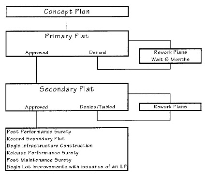
(4) Decision by the APC. Within 50 days of the public hearing concerning an application for approval of a subdivision plat, the APC shall notify the applicant in writing stating whether the primary plat is approved or disapproved.
(a) Approval. If the APC determines that the primary plat complies with the standards set forth in this chapter, it shall make written findings of fact and a decision granting primary approval to the plat.
1. The APC may introduce such changes or revisions as are deemed necessary to the best interest and general welfare of the community.
2. Approval of a primary plat by the APC signifies the general acceptability of the layout submitted.
3. Approval of a primary plat shall be effective for a maximum period of two years unless, upon application of the applicant the APC grants an extension. The APC may extend approval of a primary plat to a maximum of four years without further notice, public hearing or fees.
(b) Disapproval. If the APC disapproves a primary plat application, the APC shall make written findings of fact and notify the applicant in writing, stating the specific reasons for disapproval. This written notice shall be signed by the Chairperson and Director of the APC.
1. The applicant shall be required to observe a six-month waiting period before refiling a primary plat which has been disapproved by the APC.
2. The original applicant may submit a new application for primary plat approval in accordance with established rules of procedure.
(D) Secondary plat.
(1) Application.
(a) After approval of the primary plat by the APC and fulfillment of the requirements of this chapter, the applicant shall submit to the Director a written application for secondary plat approval, ten copies each of the secondary plat, construction plans, landscape plans, final covenants and restrictions of the subdivision and all approved required state and federal permits. The application shall be filed in accordance with filing deadlines predetermined by the APC before the meeting at which the APC is expected to consider the application. At the time of filing, the application shall be accompanied by a non-refundable application fee as indicated in the fee schedule. The Director shall surrender the application fee to the Boone County Auditor.
(b) The Director shall forward one copy to each of the individuals indicated in the previous section regarding primary plat application. Those agencies or persons shall forward any comments or recommendations concerning the plat to the Director prior to the date of the meeting at which the APC is expected to consider the application for secondary plat approval.
(2) Secondary plat plans. The plat shall be drawn at a scale of 50 feet to 1 inch, except that when the drawing at that scale requires more than one sheet, the plat may be drawn at a scale of 100 feet to 1 inch. Sheets shall not exceed 24 inches by 56 inches in size. The secondary plat shall be prepared and certified by a land surveyor and/or a professional engineer registered by the State of Indiana. The secondary plat may include all or only a part of the primary plat which has received approval. The following information shall be shown on the secondary plat, but not limited to:
(a) Name of subdivision and section number followed by the words “Secondary Plat”;
(b) Accurate boundary lines, with dimension and angles, which provide a legal survey of the tract, closing with an error of not more than one foot in 5,000 feet;
(c) Accurate distances and directions to the nearest official monument. Reference corners shall be accurately described on the plan;
(d) Accurate locations of all existing and recorded streets intersecting the boundaries of the tract;
(e) Accurate metes and bounds description of the tract boundary;
(f) Source of title of the applicant to the land as shown by the last entry in the books of the County Recorder;
(g) Street names;
(h) Complete curve data for all curves included in the plan;
(i) Street lines with accurate dimensions in feet and hundredths of feet with angles to street, alley and lot lines;
(j) Lot numbers and dimensions including the square footage of each lot;
(k) Accurate locations of easements for utilities and any limitations on the semi-public or community use;
(l) Accurate dimensions and plans for any property to be dedicated or reserved for open space or other public, semi-public or common use;
(m) Building lines and setback dimensions throughout the subdivision;
(n) Location, type, material and size of all monuments and markers;
(o) Plans and specifications for the improvements required in this chapter;
(p) Final protective covenants and restrictions which are properly prepared and legally sound which shall be incorporated into the plat and restrictions of all types which will run with the land and become covenants in the deed for lots;
(q) Name and address of the owner and subdivider;
(r) North point, scale and date;
(s) Certification of dedication of streets and other public property;
(t) Final landscaping, lighting or parking plans shall be incorporated in the secondary plat design plans when requested by the Director or the APC; and
(u) Certificate of approval by the APC.
(3) Construction plans. It shall be the responsibility of the subdivider of every proposed subdivision to have prepared and certified by a land surveyor and/or professional engineer registered in the State of Indiana, a complete set of construction plans, including profiles, cross-sections, specifications and other supporting data for all required public streets, utilities and other facilities. The final construction plans shall be based on preliminary plans which have been approved with the primary plat, and shall be prepared, submitted and distributed in conjunction with the secondary plat. The plans shall show the following.
(a) Construction plans shall be prepared for all required improvements. Plans shall be drawn on standard 24-inch by 56-inch sheets at a scale of no more than 1 inch equals 50 feet, and map sheets shall be of the same size as the primary plat.
(b) Topographic contours at intervals of one foot if the general slope of the tract is less than 5% or intervals of two feet if the slope exceeds 57. Contours shall be referenced to mean sea level elevations.
(c) Profiles showing existing and proposed elevations along center lines of all streets. Where a proposed street intersects an existing street or streets, the elevation along the center line of the existing street or streets within 100 feet of the intersection. Approximate radii of all curves, lengths of tangents and central angles on all streets. Complete curve data for all curves included in the plan.
(d) Where steep slopes exist, the APC may require that cross-sections of all proposed streets at 100-foot stations shall be shown as follows: on a line at right angles to the center line of the street, and the elevation points shall be at the center line of the street, each property line, points 25 feet inside each property line, edges of pavement, curbs, break points and ditch lines.
(e) Plans and profiles showing the location and typical cross-section of streets including curbs and gutters, sidewalks, mailboxes, rights-of-way, drainage facilities, manholes and catch basins: the location, size and invert elevations of existing and proposed sanitary sewers, storm water drains and fire hydrants, showing connection to any existing or proposed utility systems: the location of street trees, street lighting standards and street signs: and exact location and size of all water, gas or other underground utilities or structures.
(f) Location, size, elevation and other appropriate description of any other existing physical and natural features or facilities including features noted on the official maps of local government, trees with a diameter of eight inches or more (measured four feet above ground level), the points of connection to proposed facilities and utilities and the approximate high- and low-water elevations of all ponds, lakes and streams. All elevations shall be referred to the USGS datum plane.
(4) Public notice. Public notice for secondary plats shall be in accordance with the rules of procedure established by the APC.
(5) Decision by the APC. Within 60 days after application for approval of the secondary plat, the APC shall approve or disapprove it.
(a) Approval.
1. If the APC determines that the plat complies with the standards of this chapter, it shall make written findings of fact and a decision granting secondary approval to the plat. After necessary performance surety has been posted, the secondary approval of a plat by the APC shall be certified on behalf of the APC by the Chairperson and Director who shall affix their signatures to the plat original and all other relevant documents which also may require signatures.
2. One copy of the certified plat shall be forwarded to each the following persons:
a. Boone County Surveyor;
b. Boone County Auditor and Recorder;
c. Appropriate public utility that may be affected;
d. Subdivider or applicant; and
e. File of the APC.
3. A plat of a subdivision may not be filed with the Boone County Auditor and the Boone County Recorder may not record it, unless it has been granted secondary approval by the APC and has been properly signed by the Chairperson and Director of the APC. The filing and recording of the plat is without legal effect unless approved by the APC.
4. No improvement location permit shall be issued by the Director, or his or her agent, for any structure on any subdivision lots prior to the following:
a. The recording of the subdivision by the County Recorder of Boone County, Indiana, except for the purposes of public facilities;
b. Installation and completion of all improvements, including grading, as shown on the development plans and approved by the APC, except that in the case of an asphalt road surface, the installation of the final surface coat may be postponed until the end of the maintenance period. The final coat of asphalt shall be installed prior to acceptance of the road for public maintenance;
c. Written certification from the Boone County Highway Department and the Boone County Surveyor that improvements are complete; and
d. The release of necessary performance surety and the posting of necessary maintenance surety.
(b) Disapproval. If the APC disapproves the secondary plat, it shall make written findings of fact and notify the applicant in writing, stating the specific reasons for disapproval. This written notice shall be signed by the Chairperson and Director of the APC.
(Ord. 98-26, passed 12-21-1998; Am. Ord. 2004-02, passed 2-9-2004)