(A) General requirements.
(1) Final plat.
(a) The subdivider shall submit 15 folded copies of a minor subdivision plat or conveyance plat to the Administrator for processing, along with the appropriate subdivision plat review fee and application.
(b) If a subdivision improvement agreement (letter of credit, cash escrow or surety bond) is required due to incomplete installation of utility extensions, the subdivider shall submit all required information with application.
(c) Two Mylars should be submitted after approval has been granted.
(2) Construction plans (if applicable). If utility extensions are required, the subdivider shall furnish the town department ten copies of all engineering plans and specifications, prepared and endorsed by a certified professional engineer, licensed as such by the state. The engineering plans shall delineate and describe in complete detail all aspects of grading, clearing, drainage and physical improvements proposed both on and off-site, as required in relation to the proposed subdivision.
(B) Requirements for a sketch plan.
(1) Sketch plans shall be drawn to a convenient scale of not more than 100 feet to an inch. Supporting information required by this section may allow for a larger scale.
(2) Contents required:
(a) Type of development;
(b) Name, address and telephone number of developer and designer;
(c) Graphic and written scale;
(d) Proposed name of subdivision;
(e) Current zoning and district lines;
(f) Total acreage of the site;
(g) Total number of proposed lots/units and the approximate location and dimensions of all proposed or existing lots;
(h) The approximate location, dimensions and area of all parcels of land proposed to be set aside for park or playground use or other public use, or for the use of property owners in the proposed subdivision;
(i) Whenever the sketch plan covers only a part of an applicant’s contiguous holdings, the applicant shall submit, the proposed subdivision or development area, together with its proposed utilities and street system, and an indication of the probable future street system, and an indication of the probable future utilities and street and drainage system of the remaining portion of the tract;
(j) Approximate topography;
(k) Existing utilities available to the site and preliminary proposals for connection with existing water supply and sanitary sewage systems, or alternative means of providing water supply and sanitary waste treatment and disposal; preliminary provisions for collecting and discharging surface water drainage; and
(l) Proposed street names on the street/subdivision name(s) review form, if necessary.
(C) Requirements for a final plat; contents required.
(1) Legend containing subdivision names, vicinity map, legal description including township county and state, the date or dates of survey, the date of any revisions to plat, a north arrow and declaration, scale in feet per inch and bar graph, the name and address of the owner(s) and the name, address, registration number and seal of engineer and/or surveyor;
(2) Exact boundary lines of tract in heavy line, full dimensions by lengths and bearings and intersecting boundaries of adjoining lands;
(3) Street names, right-of-way lines and the location and dimensions of all easements;
(4) Accurate descriptions and locations of all monuments, markers and control points;
(5) Sufficient engineering data to determine readily and reproduce on the ground every straight or curved boundary, street and setback line including dimensions, bearings or deflection angels, radius, central angles and tangent distances for the centerline of curved streets and curved property lines that are not the boundary of curved streets. All dimensions shall be measured to the nearest tenth and angles to the nearest minute;
(6) Boundaries of floodways and 100-year floodplains;
(7) Lots numbered consecutively throughout the subdivision;
(8) The names of owners of adjoining properties;
(9) Building setbacks (in table format);
(10) Site calculations, including:
(a) Total acreage; and
(b) Total number of lots.
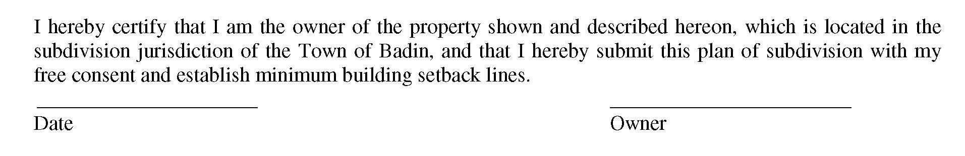
(11) The following certificates shall appear on the plat. Divisions (C)(11)(a), (C)(11)(b) and (C)(11)(c) below shall be signed when submitted. Division (C)(11)(d) below will be signed when plat is approved.
( a) Certificate of ownership and dedication.
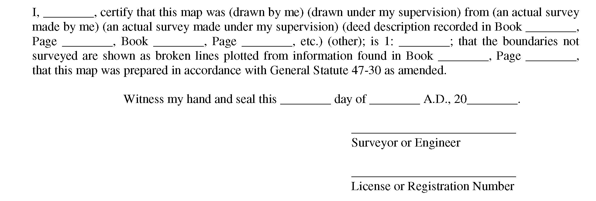
(b) Certificate of survey and accuracy.
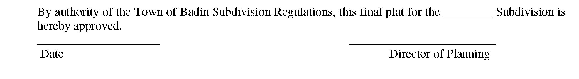
(c) Certificate of final plat approval. Upon approval of the minor subdivision final plat, by the Planning Director and Town Public Works Director or designee, the following signed certificate shall be shown on each copy of the plat reflecting such approval:
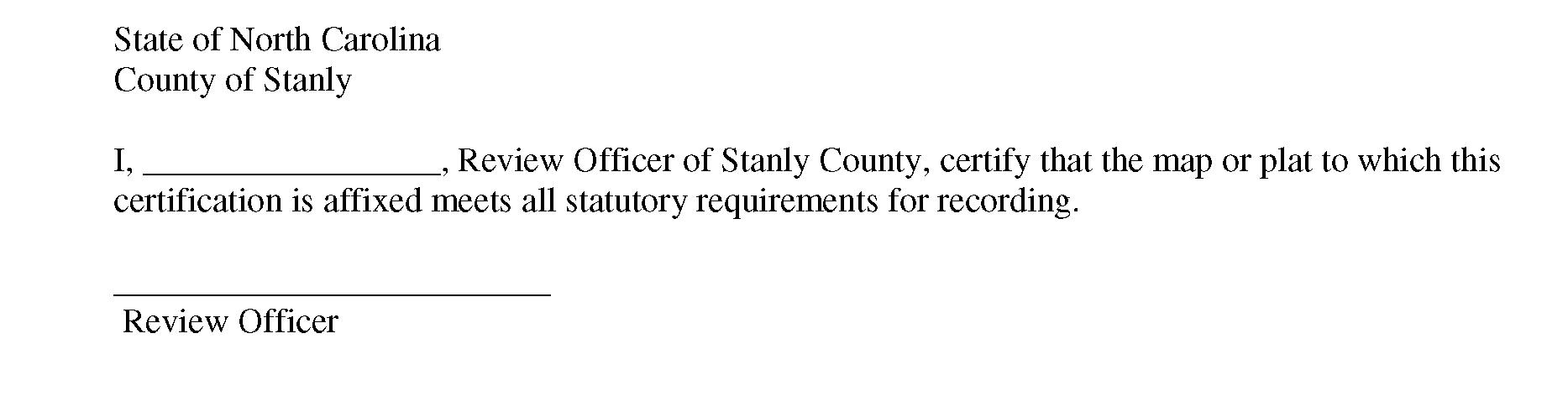
(d) Plat Review Officer certificate (as required by G.S. § 47-30.2).
(Ord. passed - -, App. B-3)